Today will feature mainly sunny skies, cold temps and moderately gusty winds as low pressure pulls east. Winds will be gutsiest along the coast closest to the storm. Highs will range from the 10’s north to the 20’s south. Winds could gust to 25mph today along the coast.
Today will feature cloudy skies, cool temps, breezy NE winds, and the chance for a flurry or two. A massive storm is churning to our south but will slide out to sea before making it far enough north to cause problems in terms of precip. Despite the fact we escaped the precip shield, we can’t escape the wind field. Winds will be gusty out of the NE and in some places that will be onshore enough to generate ocean effect flurries. A dusting is possible in far southern York County due to this. Temps will be in the 10’s and 20’s.
We continue the long stretch of cold, windy weather today as high pressure is still building in from the west. Look for highs similar to yesterday, in the 10’s and low 20’s, along with winds slightly calmer but still gusting to 20mph at times. Mainly sunny skies are expected.
Remember yesterday? That’s happening again today minus maybe 5 or 10mph on the wind. Look for highs in the 10’s and 20’s with NW winds gusting in the 20-30mph range. Not quite the 30-40mph of past days but still enough to make it feel nice and chilly. Welcome back to winter!
Remember yesterday? Yeah, that’s what to expect today with just a hint less wind. NW winds will still be gusting over 30mph, actual temps will hover in the 20’s with wind chills not far removed from zero, and blowing/drifting snow will continue to cause sporadic slick spots/low visibility. Just another day in Maine.
Today will feature mainly sunny skies though winds will be blowing and temps will be dropping. Look for temps right around 20 at the coast and in the low to mid 10’s north. Winds could gust over 35mph thus bringing wind chills below zero for many. Here in Yarmouth we’ve picked up 9″ of fluff this weekend (5″ Saturday, 4″ yesterday) and by the looks of it most areas saw at least 6″ of fluff over the weekend as well. This snow will take to the skies today with all the wind and blowing/drifting snow could cause issues in terms of reduced visibility and possibly some slick spots as well if the snow happens to drift into the roads. Use caution if out and about today. In the mountains, a very favorable upslope pattern is setting up and 4-8″ of upslope snow is likely in the favored areas. Watch for that if you’re heading north.
You may’ve heard about a storm this weekend. As of now, monitor for details as they become available tonight and especially tomorrow but it looks like we just get a glancing blow as the storm slides south. Many solutions are still on the table so continue to monitor the forecast over the next few days.
The forecast for snow today remains on track and light snow will continue to fall through the day as the Norlun trough meanders over the region. Accumulations will be light for most with a general coating-2″ expected. More is possible in southern NH. Temps will be in the 10’s north and 20’s south.
A tricky forecast is lined up for tomorrow as a Norlun trough develops over the area. The players remain largely the same as when I wrote yesterday’s post so please check that out for an explaination of the situation. These are tricky to forecast so anyone in SW ME, southern NH, and NE MA should be prepared for a coating-4″. Again, please check out last night’s post for details on the setup. I’ll repost last night’s snow map below as I see no reason to change it. The only thing different from last night’s post is that it appears unlikely any mesolow feature would form in time to provide meaningful impacts but if you want to learn how they work, that’s an interesting read.
Today will feature high pressure briefly nosing in from the north as yesterday’s storm departs and tomorrow’s storm approaches from the south. Look for highs in the 20’s north and low 30’s south. Another storm will pass well SE of the area tonight into tomorrow but indications are a Norlun trough will develop on the back side leading to locally moderate snow somewhere along the coast. I’ll be back this evening to talk about the details.
After a nice little storm today, we turn sunnier and cooler tomorrow as low pressure moves east. Another low is already developing in the Gulf of Mexico and will be moving offshore well to our SE Monday. Normally, this would be a slam dunk miss but a strong upper low will be driving SE and there’s a lot of energy on the leading edge. Surface low pressure will develop over the Great Lakes in response to the upper low and a surface trough will develop between the Great Lakes low and the offshore low. This sets up a tricky forecast for Monday as this trough could take on some Norlun traits leading to narrow and possibly heavy snow bands.
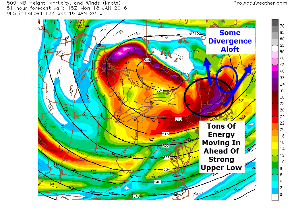
12Z GFS Showing A Very Favorable Setup For A Norlun Event. Image Credit: Accuweather
Looking at the 500mb setup, there are a lot of things going for a Norlun event. A strong upper low is moving in from the NW and on the leading edge, a strong peice of energy is moving right over us. Also, being ahead of the upper low, the flow aloft is divergent. To put this in simpler terms, the air at 20,000 feet is spreading out. This leaves a void that air from below must rise to fill. Think of what happens when you pull your hands apart on the surface of a lake or bath. Water rises to replace the water you pushed to the side. This rising motion helps generate precip. This is how everyone will see a coating to an inch or two of snow tomorrow night into Monday morning. The real fun is along the southern coast with a Norlun trough.
At the surface a storm will blast by well SE tomorrow. Another weak wave will develop over the great lakes. The link between the two will manifest itself in the form of a Norlun trough extending NW-SE across the area. Everyone sees light snow from synoptic (large) scale divergence aloft but any moderate snow amounts will be dominated by a mesoscale (small) norlun trough. These troughs generate narrow, heavy snow bands (think lake effect type) that can drop moderate to heavy accumulations in one town while the next town over sees some flurries and maybe a coating. My point here is that uncertainty is quite high.
Graphic Showing How A Low Forms Off The Maine Coast With Strong West Winds. Credit: Me
Another thing to watch out for with Norlun type events is the threat for a mesolow to develop. Mesolows are caused by rising air along and near the trough and also westerly winds accelerating and veering as they move from a high friction environment (over land) into a low friction environment (over water). Imagine the right front tire of your car running into a patch of ice. As that tire moves from a high friction environment (pavement) into a low friction environment (ice) it accelerates while the left front tire is stuck on the high friction pavement and can’t move as fast. The result is your car spinning out. The same thing happens with air moving from over land to over water. Above I’ve drawn up a quick graphic showing how west winds and a cold airmass emerging over water can generate a low. The divergence aloft and strong upper energy aids in this process. This doesn’t happen behind every cold front because often the air is and sinking. The air monday will be rising due to the approaching upper low/divergence which will help with the development of the low.
12Z CMC Showing The Potential For A Mesolow Along The Coast Monday Afternoon. Credit: Weatherbell
The 12Z CMC shows this potential well. Should this occur, most of the coast could see a moderate snowfall and amounts would be slightly less dependant on the fickle Norlun. While most models don’t show this, based on warm waters (still over 40 degrees!), rising air ahead of the upper low, the strong energy aloft, and the movement of the surface airmass, I think there is a good chance some sort of mesolow develops and strengthens tomorrow afternoon.
Here are my thoughts for snow. This is tentative as Norlun troughs are notoriously fickle. I’ll have another update tomorrow morning.