Hello everyone!
Today will be a lot like yesterday but a tad warmer (3-5 degrees or so) and less windy. Highs look to be in the low 50’s south and low 40’s north under sunny skies.
-Jack

Hello everyone!
Today will be a lot like yesterday but a tad warmer (3-5 degrees or so) and less windy. Highs look to be in the low 50’s south and low 40’s north under sunny skies.
-Jack
Hello everyone!
Cool and breezy today, highs will rise into the upper 30’s/low 40’s up north and upper 40’s/low 50’s south with NW winds gusting over 30mph at times. Today’s winds will be the typical upslope/downslope combo with the mountains seeing clouds and some showers/flurries (highest elevations likely pick up 2-4″ of new snow) and the coastal plain seeing sunny conditions.
-Jack
Hello everyone!
Winds kick up today behind a departing front that brought last night’s rain. Expect gusts in the 20-30mph range with highest winds at the coast and at elevation. Because of this some isolated power outages are possible but major problems are not expected. Temps will be mild as well today with highs in the mid to upper 50’s along the coast, cooler north. Showers are possible region-wide this afternoon but a washout is not expected.
-Jack
Hello everyone!
Rain is on our doorstep again this morning associated with an approaching cold front. Expect cloudy conditions this morning but rain holds off until the afternoon hours arriving west to east during the mid to late afternoon. Temps will be chilly, in the 40’s.
-Jack
Hello everyone!
Our next storm is on the doorstep and is currently causing blizzard conditions in Colorado and Tornadoes in Iowa. It will lose much of its might though by the time it arrives here so some rain and breezy winds are likely the extent of the impacts we will see with this one.
Rain is likely to move in tomorrow afternoon from SW to NE and will be light to moderate in nature. Winds will be slightly stronger than normal out of the S/SE but gusts should remain around 20mph. All in all, nothing too big or unusual for November.
Rain clears out Friday and more normal fall temps move in for the weekend with upslope snow showers as well. More above normal temps are expected for much of next week.
-Jack
Hello everyone!
We’re heading back to the 50’s today for highs but this time we will be seeing more clouds as our next storm approaches. All in all, not a perfect day but not a bad one either.
Rain and wind arrive for the coast tomorrow but it won’t be that big a deal. I will likely not have enough time for an evening update with several school functions to attend tonight but the full rain/wind forecast will be up tomorrow morning.
-Jack
Hello everyone!
A quick update this evening to keep everyone up to speed on the next chance for inclement weather heading into the middle/later part of this week.
The 18Z GFS shows us some of the main players in Wednesday’s storm. While the 18Z GFS usually isn’t that reliable and while I hate to use the GFS in the short term, it offers the most reasonable solution (as well as the Euro which I can’t post). Most other models have a stronger storm which I still have doubts about given the lack of upper level support. Not too complex a storm here, we’re looking at steady moderate rain for a few hours Wednesday morning into early afternoon along the coast with inland showers around the same time inland. Winds will be breezy with gusts in the 20-30 mph range most likely along the coast, lesser but still active winds inland. Rain wraps up by evening as the storm moves offshore.
More rain arrives late in the day Thursday in association with a front moving in from the west.
Updates will stay on the twice a day schedule until the weather returns to its state of calm we’ve grown so accustomed to recently.
-Jack
Hello everyone!
We continue our remarkable streak of lovely weather today with sunny skies and highs ranging through the 50’s. Enjoy it while it lasts though because we do have a few wetter days ahead.
-Jack
Hello everyone!
I’m going to start up evening updates on an as-needed basis this week as we have two shots at some rain in the next 5 days.
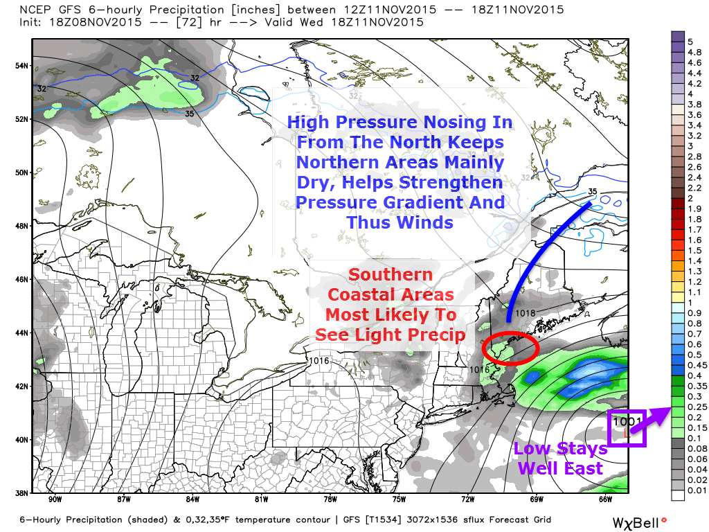
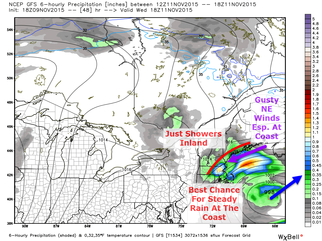
A low pressure system will develop offshore Tuesday and move NE up the coast but before it reaches Cape Cod, it looks to turn east and away from the coast. The upper level pattern is very conducive to this motion and the energy sparking this storm is very weak so it does not look to be a big storm. What is big though is the high pressure center up in northern Quebec/Labrador. A piece of this sprawling high will likely extend down into Maine which will help to create a respectable but certainly not impressive pressure gradient Wednesday which will lead to some gustier than normal winds. For northern areas, expect slightly breezier conditions and mainly cloudy skies but little/no precip. Coastal areas look to see breezy conditions with drizzle/showers likely. All in all, nothing intense but a dreary day nonetheless.
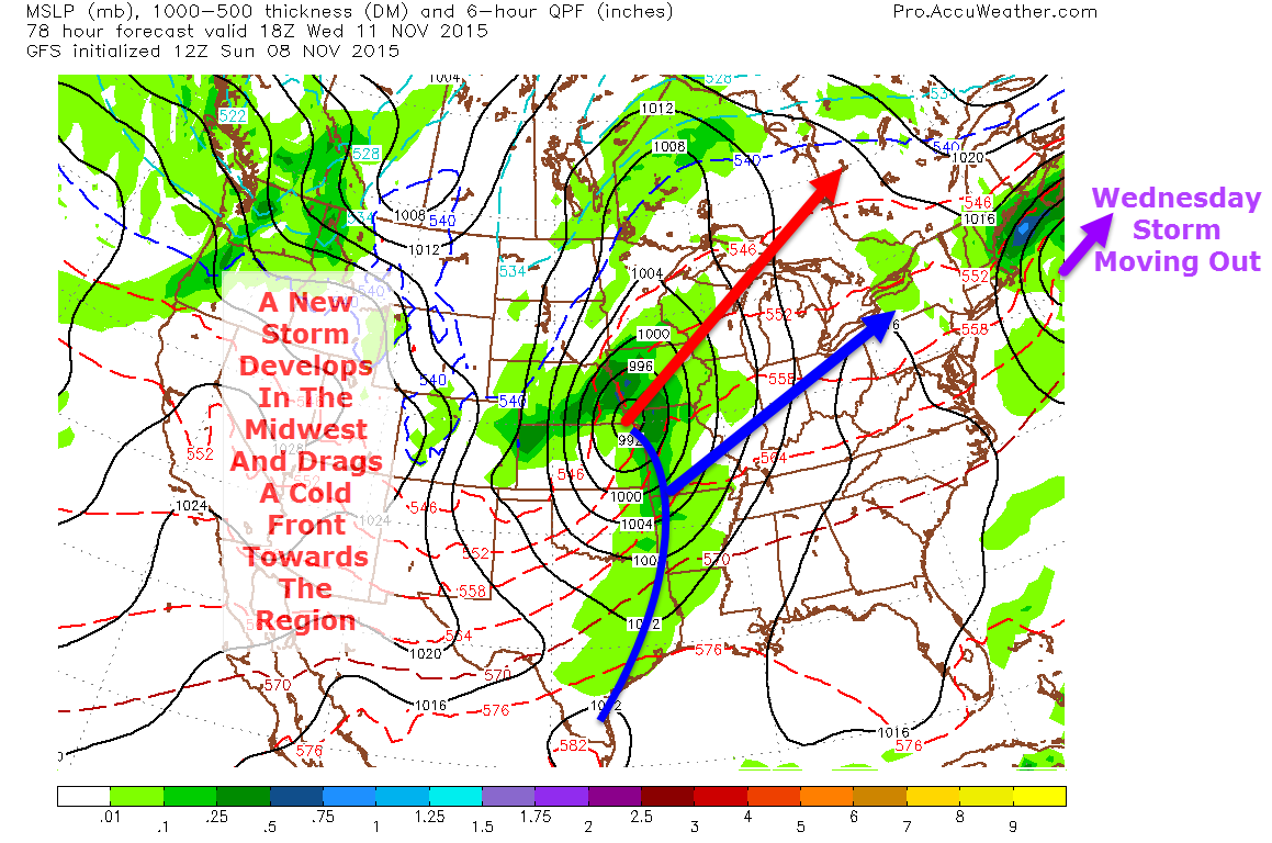
A new storm will be developing at the same time over the Central US and will drag a cold front towards the region for Thursday evening into Friday. While the current timing is not conducive to any mixed precip, should the storm arrive a little earlier closer to Thursday morning or a little later more towards early Friday morning, the mountains would have to watch for some light icing at the onset. As of now this does not appear to be an issue but it is something to keep an eye on.
This wouldn’t be a bad time to check up on your salt/sand supply as even if this icing event does not materialize, there will be more down the road and now is the perfect time to make sure you’re ready for the winter weather that lies ahead.
Should the current forecast remain unchanged, the rain would occur mainly during the overnight hours Thursday before clearing up Friday morning.
A shot of colder air lurks behind this system for next weekend.
I’ll have another update on tomorrow’s weather tomorrow morning and another update on these rain events this time tomorrow evening.
-Jack
