Hello everyone!
Today will feature increasing clouds in advance of our next storm system approaching from the west. Expect sun this morning with clouds rolling in during the lunchtime hours. Highs today will range from the low 20’s up north to near 30 in the south. Snow should wait until the late evening hours before moving into Maine though SW NH could see flakes as early as 3 or 4 this afternoon.

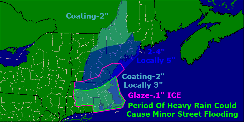
Here is my thinking as to snow accumulations for this event. Watch out for a little ice in southern areas as above freezing air moves in aloft but the deep snowpack keeps the cold locked in at the surface. Warm air does look to move in at the surface down in the Boston area before the precip shuts off so watch for a period of heavy rain tonight which could cause some localized street flooding given all the snow on the ground.
No other storms are in sight as of now.
-Jack
7:45 pm EST Thursday 2-23-12:
New forecasts coming in now and still trending cooler. This means that the secondary low will develop more quickly and reach a greater intensity before being driven off by approaching high pressure that will be building in for Saturday.
Low will approach the area tonight and snow will start at around 5:30am. Little accumulation before dawn but this thin layer will set the stage for more efficient accumulations with heavy snows later. Heavy snow will come with the 2nd low forming roughly 50 miles NE of Boston. This new low will start out fairly strong and will continue to deepen though cyclogenisis is not expected at this point. The new low will start to pull in sufficient cold air starting around 11:00. Warm air advection (which is warm air interacting with cold air usually overtaking it and produces precipitation) will be halted or significantly slowed by this point due to cool air being wrapped in by this point by the secondary low.
East winds brought on by the secondary low passing south of us will draw in warmer air along the coast and we will see a change to sleet possibly mixing with rain.
Snow amounts: Southern York County: 1-3″
Coast north of Portland to 20 miles inland: 3-5″
Inland and foothills: 4-6″
Mountains: 6-10″
Stay tuned!
-Jack
Reliably hype-free weather info for Western Maine and New Hampshire from amateur forecaster Jack Sillin