Tag Archives: Cold air damming

Historic snow targeting New England.

After days and days of model diversion, some agreements are being reached. The one big agreement is that there will be a strong low moving up the north east coast. A classic Noreaster enchanced with extra gulf moisture and another “clipper” system as well.

Now lets dig deeper. There is currently a disturbance in the Gulf Of Mexico (GOM) that is producing heavy rains in TX/LA currently.
noreaster 3
Map of disturbance in GOM.
This disturbance will move NE over FL and emerge of the carolinas tomorrow. Tomorrow night things really get going with the low moing NNE towards the famed 40, 70 benchmark. This is a point on the map we meterologists look at a lot to determine the effects of a storm. Anyway, as the low approaches this location SE of Boston, it will stall out for about 6 hours while absorbing the northern low pressure and rapidly intensifying. The result will be insane snow bands Friday afternoon/night. There will be a minor break in the action some time friday evening however, another push of snow on the back side of this system will drop more snow Saturday and with high winds, blizzard conditions are likely.
snow 2c
Snow map for Friday/Saturday storm.

For everyone wondering about the snow day potential here in ME, its really on the line. Friday morning will be pretty much clear as far as I can see but the afternoon gets tricky. Most likely early dismissal. Stay tuned for tomorrow nights update!
-JAck SIllin

Full update on winter storms

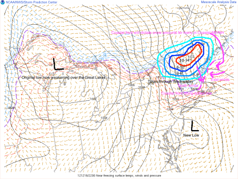
We are now on a wild roller coaster ride when it comes to the weather in the North East. A low pressure system is moving out of the Great Lakes and will be transferring its energy to a secondary low off the NJ coast.

noreaster 12


Graphic overview of storms.

As you can see, there are many factors playing into the forecast. The coastal front, the new low, cold air damming. Cold air damming is when  the heavy cold air stops the advance of Warm air. Where exactly the cold air dam sets up will play a big part in the type of precipitation. The coastal front will play an equally important part on determining precipitation types. As shown, the east winds off the warm water will bring in warmer air. This will turn snow/sleet/freezing rain into all rain. Expect this to move inland Monday-tuesday.

After the coastal front moves inland, Wednesday will already be here as will another storm. This new storm will be MUCH stronger.

noreaster 13


This graphic depicts the setup Monday-Wednesday. The coastal front from tonight will move way inland turning everyone except the ski resorts over to plain rain. The wednesday low will move swiftly through the Gulf of Maine and into the Canadian Maritimes. On the backside of this system the cold air will make a comeback turning everyone back over to snow Wednesday evening-night. Accumulations should be light.

After we get the Monday and Wednesday storms out of the way, there will be yet another low Friday. This is a little too far out to accurately forecast so I will detail that in a later Post coming Wednesday-Thursday.

-Jack