Everything is lining up as forecast and a long duration light snow event is likely today. Snow looks to arrive around noon here in Maine, a little earlier along the coast, and a little later inland towards the mountains. Not much has changed since yesterday in terms of expected snowfall. I still think the coast has the best shot at hefty snowfall amounts. Keep in mind, snow will be able to accumulate quite efficiently despite snow never falling that heavily. The good news with the light snow is that it will be easily moved by your shovel. The bad news is that it will be equally easily moved by the strong winds today that will gust along the coast to near or over 30mph. As a result, expect blowing and drifting of the snow not only that is just falling, but also of the 6″+ of snowpack most coastal areas have left over from Friday’s storm. This is likely to cause visibility issues especially for the evening commute.
HRRR Model Showing Heavy Snow Remaining South But Light Snow Impacting Maine Today. Credit: Weatherbell
Here is the HRRR model just to give you an idea of how the storm plays out in general. Don’t take it word for word in terms of individual bands or timing down to 15 minutes but look at it to get the general idea of the heavy stuff remaining south and the light stuff sitting over us for a while.
Temps today will be in the 10’s and 20’s.
Snow winds down tomorrow afternoon though snow showers will continue through Thursday as various pieces of energy rotate around an upper trough to our west.
A powerful storm is bombing out over the ocean near the Carolinas this evening and we will be on the far western edge. At the same time, a complex upper low is diving SE across the upper Midwest. They will form a connection of sorts that will transport warm moist air over the cold air moving in tonight following today’s cold front.
12Z GFS Showing Mositure Connection Between Clipper And Coastal Storm. Image Credit: Accuweather
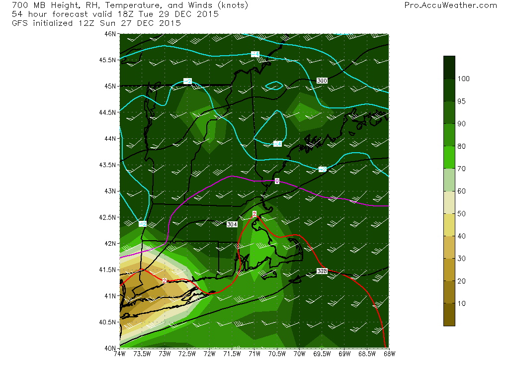
The coastal monster will stay mainly offshore but it will throw a ton of moisture back to the NW. There is a clipper to the NW which is ready to receive this moisture and will help draw it back NW. Bottom line: there will be a feed of moisture over the area tomorrow as moisture from the coastal low gets pulled back into the clipper. If you watched my video discussing the Friday storm, you know that we need three things for snow: moisture, cold, and lift. We got the cold today with that Arctic front and above is the moisture. The problem though is the lift.
12Z GFS Model Showing Broad But Light Lift Tomorrow Evening. Image Credit: Accuweather
As the warm air providing the moisture rises up and over the cold air at the surface we got today, it will rise, cool, and condense into precip. Sometimes, this mechanism for forcing (getting air to rise) can be quite effective in producing heavy precip. Not so much this time. If you’ve followed along for a while, you’ll know that I use Vertical Velocity to show how much air is rising and thus how heavy precip will be. In the big storms, you’ll often see bright purples and reds (notice scale on right of image). This time, we see yellows and oranges. This is indication that there will be less mesoscale banding and more broad lighter precip. Therefore, look for lighter snow though it will last long enough for fairly heavy accumulations.
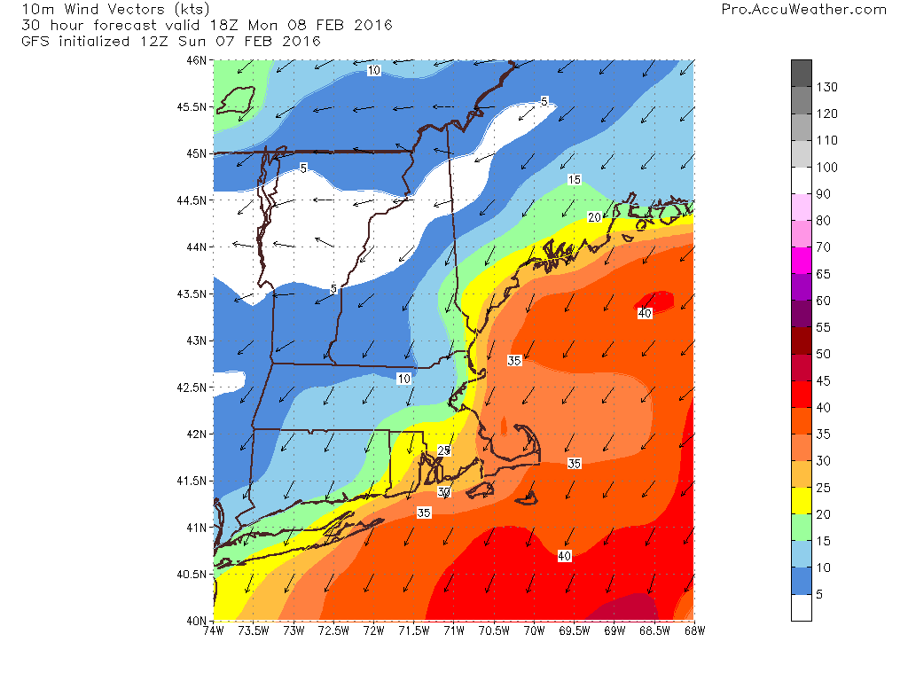
This snow will be light and dry which is nice for shoveling but will be unfortunate because the gusty winds will have no problem blowing around the light, fluffy snow. For this reason, expect blowing and drifting snow to cause visibility issues especially tomorrow afternoon (map valid 1PM tomorrow). Winds are likely to range from near calm in the mountains to over 30mph at the coast.
Here’s what I expect in terms of total snowfall. Keep in mind, this falls over a near 30 hour period from late morning tomorrow through Tuesday afternoon. Slow and steady is the name of the game for this one.
Most of the heavy snow and sleet is off to our NE now as the mid levels dry out. Despite a lack of heavy precip, snow and sleet will still remain across the area this evening with another inch or so of snow and a coating of sleet and possibly a glaze of freezing rain as well. This continued light precip will cause roads to remain slick through the next few hours so continue to use caution if travelling.
Seeing as the storm is winding down, this will be my last update today. I’ll be back tomorrow morning with a look at tomorrow’s weather.
-Jack
10:30 AM Update
Heavy snow and sleet is ongoing across the region currently although the worst of the worst is now mainly NE of Portland. I expect moderate to heavy snow and sleet to continue for the next few hours with the worst gradually sliding NE. This afternoon, look for the second phase of the storm which is already beginning across southern areas which includes lighter mixed precip.
In Yarmouth, what I’ve been seeing generally seems to match up with other reports I’m seeing on mPING and on Twitter from folks across southern areas. Snow has been heavy here and is mixing with sleet. The sleet is piling up though, I’ve gotten about an inch of sleet on top of 4.5″ of snow as of 10:30. Keep in mind everything is still quite slick out there so use caution if traveling!
-Jack
7:45 AM Update
Snow continues across the region this morning. Here in Yarmouth, there was a period of sleet around 7 but the precip has since turned back to all snow as heavier precip moved in. As of 7:45, the precip remains all snow with very efficient accumulation. Due to cold temps around the area (10’s for most, 20’s coastal York county), the snow is dry and fluffy. I suggest shoveling/snowblowing now before the sleet turns the snow into frozen cement. Snow and sleet will continue with sleet moving north east through the morning. It seems that a middle of the road solution is playing out across areas north of York County with snow during times of heavy precip and sleet when precip is lighter. This will continue through the morning.
There are reports of many accidents across the are this morning and roads are very slick especially if your area is seeing sleet. Use extra caution on the roads today if you must travel. Also, remember to use your mPING app today! There has already been tons of great data flowing in and it’s really helping with the forecast!
-Jack
Original 6:15 AM Update
Hello everyone!
Today will feature a messy winter storm as low pressure moves through the Great Lakes. Warm air will be rising up and over a well-defined cold pool at the surface. This is the lifting that will produce moderate to heavy precip today. I’ve been digging into the depths of the forecast the past few evenings and now it’s time to bring it all together.
Morning Snow
HRRR Model IDEA On How Precip Unfolds This Morning. Keep In Mind This Appears To Be On The Cooler Side Of The Solutions. Credit: Weatherbell
Snow is falling across northern parts of New England this morning. Sleet has mixed in as far north as Manchester, NH as well indicating a warm layer already developing aloft. There are two possible solutions with this morning’s snowfall. Our first option is that the sleet line progresses as it has in the past hour unimpeded in its relentless march NE. This would result in sleet arriving during the heaviest of the precip, several hours earlier than last night’s forecast. Should this occur, look for totals lower or just under the lower end of the range from last night’s map (re-posted below). The other idea (this is the one you see above with the HRRR) is that the precip is so heavy that it dynamically cools the atmosphere. This has to do with the displacement of mass and is a topic for another day but the point is that if this occurs, the mid levels of the atmosphere could cool enough to allow for a little more precip to fall as snow thus resulting in totals more towards the middle or even upper end of the total ranges. Be prepared for either of these solutions. Remember even though it accumulates more slowly, sleet is icier and more slippery than snow. It is harder to drive in. Take it slow out there this morning.
Lingering Precip This Afternoon
After the initial burst of snow comes through this morning, precip will shift to a lighter more spotty type. This will fall any number of ways depending on your location. A mix of snow, sleet, and freezing rain is likely across the south with snow and sleet farther north and all snow up in the mountains. The freezing rain expected across the south will continue to cause very slick roads. Slick travel is expected everywhere today but in terms of a complete lack of traction, nothing beats .1-.3″ of ice on top of an inch or two of sleet on top of 4-6″ of snow.
Help Forecasters Track The Storm!
Given the plethora of precip types incoming with this storm, tomorrow would be a great time to give the mPING app a workout! Over the past few days you’ve seen how hard it is to forecast multiple precip types. Here’s a chance for you to help forecasters out! Simply download the free app and take a look outside! Send in your report of snow, sleet, freezing rain, or rain and you can help forecasters like me with forecasting multiple precip type events! The data is sent to the National Severe Storms Laboratory to help with radar development which gives models better data which improves forecasts. Read all about it over on the NSSL webpage. Also through that website, you can view your report and everyone else’s reports to track the rain/snow/sleet line in real-time! This is one of my most valuable tools for tracking the mix line to verify the forecast/make adjustments if needed. Happy reporting!
Totals
Forecast Total Snow/Ice Through Tuesday Night
I keep my map the same this morning as I think each solution (warm or cold) is equally likely. There are interesting radar trends that indicate the colder solution is playing out though you can’t go against hurricane force winds 10,000 feet up blasting in warm air.
Live Blog
We’ll know more as the morning goes on and I’ll keep updating this post as I see changes happening. Keep checking back right here through the morning and I’ll have new info at the top of the page as it comes in. I will also be on twitter with updates all morning @JackSillin.
Here is the link to last night’s post as the information there more or less remains the same.
A cold front is currently moving east through the region and will push offshore this evening. Behind it, a sprawling high pressure system will build in straight from Western Canada bringing with it our first real shot of cold air. On Tuesday, warm air from the tropics blasted up the coast by the storm currently causing trouble in Texas will smash into the cold air and a good burst of snow will result. Here’s how I think it will play out and why.
The Cold Air: Tomorrow
12Z GFS Model Idea Of High Temps Tomorrow Showing Very Cold Air In Place. Credit: Weatherbell
Highs will remain below freezing tomorrow for everyone except maybe far southern York County. Highs near the international border will struggle to get out of the single digits. That doesn’t include the NW breeze which will definitely be felt. This is our source of cold air for Tuesday. Prepare for January like temps and wind chills which compared to this torch of a December will feel quite chilly!
The Moisture: Monday Night
12Z GFS Model Showing Moisture From The Gulf Of Mexico Plowing Northward Monday Night. Image Credit: Weatherbell
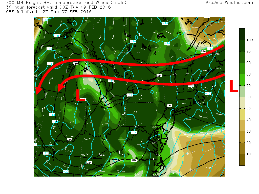
At the same time, the storm that is bringing a slew of problems to Texas will be moving North through the Ohio valley. This will set up a feed of warm moist air from the Gulf of Mexico right up the coast to Maine. This will cause some concerns as the moist air also comes with warmth which will cause concerns for mixing towards the end.
The Collision: Tuesday
The cold air comes tomorrow and the moisture arrives on Tuesday. The collision is what will cause the snow. At the moment this looks like a front end thump of snow during the day Tuesday followed by a lighter period of mixed snow/sleet/freezing drizzle/drizzle on Tuesday night. Let’s dig into the snow first.
12Z GFS Model Showing Strong Plenty Of Energy To Produce Heavy Snow Tuesday Afternoon. Credit: Accuweather
As warm air plows northward, it will run into the cold air that arrives tonight into tomorrow. This will allow for heavy snow to form on the leading edge of the warm air as it is forced up and over the cold air. This map from the 12Z GFS shows strong forcing (that’s how the moisture in the air is squeezed out) Tuesday morning. Expect slick roads and heavy snow starting Tuesday morning and lasting through Tuesday afternoon/evening. This is when most of the snow will fall. A general 4-8″ is expected with some seeing more and some less. See the snowfall map below for more details.
Mixing Concerns
12Z GFS Showing Warm Air Aloft Creeping In Tuesday Afternoon. Credit: Accuweather
Southwest winds bringing the warm moist air into the region will eventually bring in warm enough air to start causing mixing problems especially in Southern New England. My current thinking is that Warm air aloft gets as far north as the MA state line during the tail end of the steady precip. Lighter precip will linger through the evening and areas as far north as Portland could see some light sleet/freezing rain overnight Tuesday. If warm air moves in earlier/farther north than forecast which is a possibility, totals could be cut down in SW ME and NH. Northeast of route 26 is likely safe from any impactful sleet.
12Z CMC Showing A Tight Temperature Gradient Along The Coast Associated With The Coastal Front. Image Credit: Weatherbell
The other concern for precip type will be along the immediate coast where a coastal front is likely to form. There will likely be a tight temperature gradient along this front and if you end up on the SE side, temps could rise high enough to change the precip to a rain/snow mix. This threat is greatest along the coast south of Portland and along the tips of the peninsulas. Wherever this sets up, look just to the NW for heavier precip associated with the warm ocean air moving up and over the cold locked in at the surface. Warm air rising over cold air is what is causing this whole mess on a large scale, the same thing happens on a small scale.
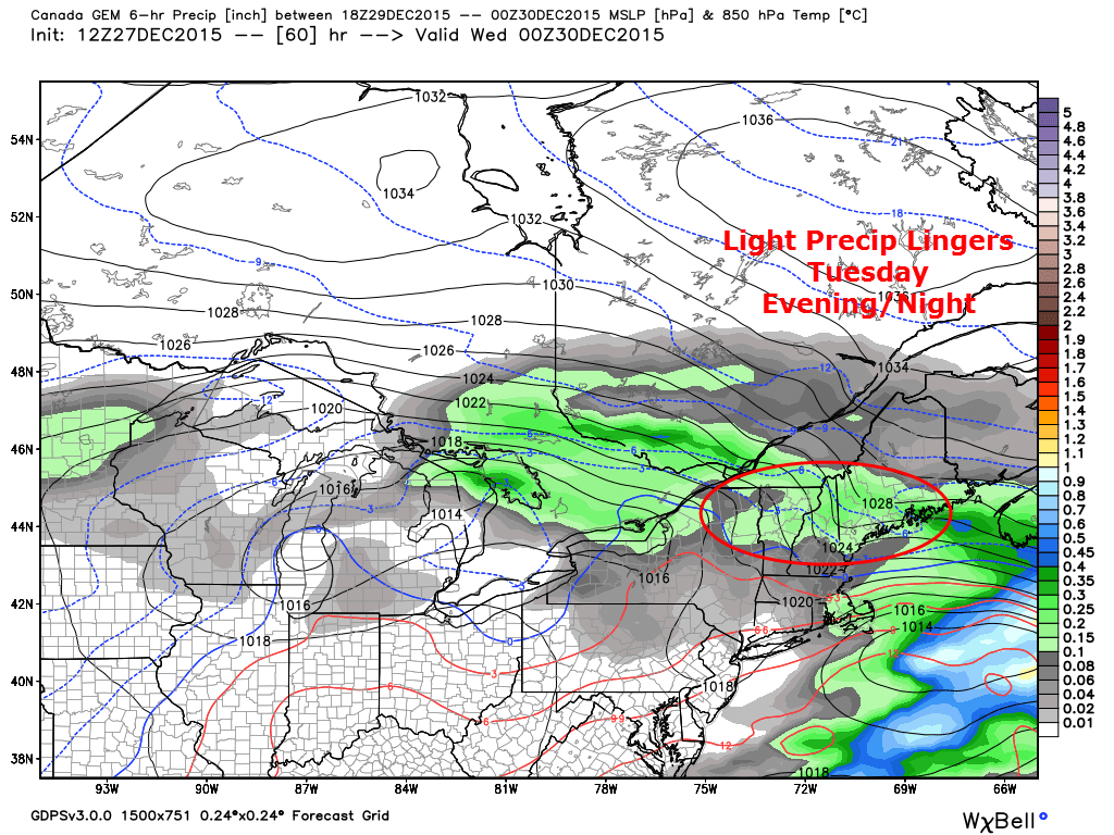
After the main snow event moves east Tuesday evening, lingering low level moisture will contribute to light mixed precip lingering through the first half of Tuesday night. As warm air completes its invasion aloft Tuesday evening, this could fall any of a number of ways, snow, sleet, freezing rain, or rain. The precip will be light so the impact on snowfall totals will be limited.
I’m thinking that because the moisture is below the warm layers, it stays mostly snow. The warm air moves in at 700mb (10,000 feet or so) but the cold stays tough below that (the blue lines on the map above indicate subfreezing temps at 5,000 feet). The moisture is in the low levels (where the cold air is) and thus even though 700mb is warm, I could definitely see another inch of snow as the snow falls in the low level cold layer. Regardless, this will keep roads slick through Tuesday night despite the heavy precip being gone.
Expected Snowfall
Expected Snowfall
Looking at the final snowfall amounts, I expect a general 4-8″ for Northern New England with less to the south. I think someone sees 10 or 11″ and the best chance looks to be either in the mountains where deep cold stays really locked in contributing to a drier snowfall that accumulates faster or near the coast where the coastal front contributes to more liquid falling from the sky. The coastal ‘jackpot’ area largely depends on the ocean air staying farther SE and the sleet being kept at bay. The northern Jackpot is dependant on enough moisture moving that far north. A coastal low developing Tuesday evening will try to steal some of the moisture from NW areas.
I’ll have another update tomorrow evening on the storm, details on tomorrow’s weather will come tomorrow morning.
Winter is making a big offensive push against the torch this week and Maine is right on the front lines. We have three storm threats this week, tomorrow, Tuesday, and Thursday/Friday. This post will focus mostly on tomorrow. I’ll have full updates on Tuesday’s storm threat starting tomorrow evening. Due to how far out the New Year’s storm threat is, I’ll save that for after we clear the first two.
Tomorrow’s Storm
18Z HRRR Model IDEA On How Precip Overspreads The Area Tonight. Credit: Weatherbell
Rain and snow will move into the region late tonight into tomorrow morning. Look for initial mix for most areas turning to rain first at the coast and then inland. Everyone is at risk for slick spots in the morning even the coast. Major issues aren’t expected but just use extra caution and remember, roads start to get slick around 35 degrees so even if your car thermometer says 34, that doesn’t mean that roads can’t slick up.
6Z GFS Model IDEA Of Where The Mix Line Could Be Tomorrow Afternoon. Image Credit: Accuweather
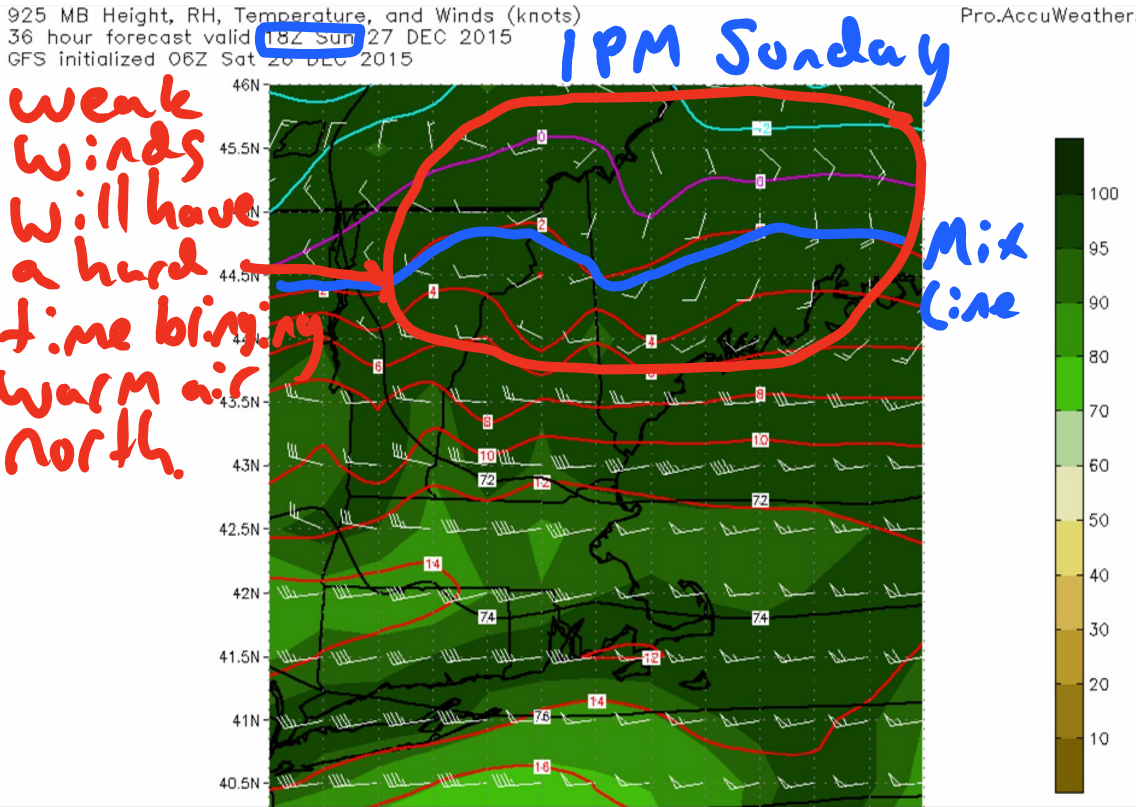
The rain/snow line will creep northward tomorrow and cold air will become entrenched just east of the mountains. As a result, this becomes a 3 part storm. Coastal/Southern rain, foothills/inland mix, and mountain/northern snow. Look below for a complete impact map. My biggest concern here is the weak winds aloft. I think the models are too quick to warm the mid levels of the atmosphere given a lack of strong winds to blast warm air in. If there are surprises with this storm one of them very well could be areas near/just south of Route 2 stay snowier for longer.
Another thing to be worried about here is Cold Air Damming and associated icing threats right up near the mountains. Winds will be southeasterly and will thus warm air at the surface will flood most areas. Temps will cool this evening setting up a pool of cold air. This will easily be pushed NW for the most part by SE winds. The cold pool of air will run into issues near the mountains though as it can’t really go anywhere. Cold dense air doesn’t like to climb mountains and I think that while eventually the SE winds will gather the energy to get the cold air out of there but I think it could take a while. Don’t be surprised if there is a little more freezing rain/sleet/snow than forecast.
A Look At What To Expect For Tomorrow’s Storm
Tuesday Storm
12Z CMC Model Showing The Major Players In Tuesday’s Event. Image Credit: Weatherbell
Behind tomorrow’s storm comes a large area of Canadian high pressure. This will ensure a steady supply of cold dry air to do battle with a steady flow of Gulf of Mexico moisture. This battle is what will produce our snow. With such massive, powerful, and cold high pressure close to our north, I have a hard time believing there will be any widespread intrusion of warm air for Northern New England. Rain could make an appearance at the immediate coast but it’s about 5,000 feet above our heads that warm air could present the most problems.
18Z NAM Showing Warm Air Moving In Aloft Allowing For Snow To Mix With Sleet In SW Areas. Areas In Green Are At The Greatest Risk For Sleet According To This Model Depiction. Image Credit: Accuweather
Here is the 18Z NAM temps 5,000 feet up Tuesday Evening. By this time most of the heavy snow will be out of the way but This map shows how warm air will be rapidly approaching the region as precip is rapidly leaving. It is too early to tell exactly who will change to sleet and for how long but just be aware of the potential especially for SW areas. If totals come in a little lower than expected, this might be why.
18Z GFS Showing The Players In The Forecast Tuesday Evening. Image Credit: Weatherbell
This event looks like a heavy burst of snow followed by a lighter, drizzlier precip. The exact timing is still to be determined but sometime during the day looks like the most likely time for a 6 hour or so burst of heavy snow before the mid levels dry out enough to shut off the steady precip. After the first burst of snow, look for lighter snow/sleet/freezing drizzle. This remaining light precip should taper off Tuesday night before fully clearing out Wednesday morning.
A coastal low will also develop and move east Tuesday evening bringing with it the tropical moisture connection. Its development will also help keep cold air locked in inland and will intensify a coastal front that is likely to develop along the immediate coast. The GFS also shows the light and showery nature of precip Tuesday Evening.
18Z GFS Showing The Development Of A Sharp Coastal Front As Low Pressure Develops Off The Coast. Image Credit: Weatherbell.
In terms of amounts, too early to tell is the name of the game for now. The most I could see out of this event is 6-10″ probably across the foothills into the western mountains. The coastal low will likely keep the moisture SE enough so that Jackman north won’t see as much liquid. The coast is at the mercy of the coastal front and warmer temps while SW areas could see sleet mixing. I’ll have more details tomorrow evening on amounts but a general 4-8″ seems likely with some 10″ amounts definitely possible.
We get a quick break Wednesday but never really clear out fully before our next storm arrives Thursday. That one looks like mainly rain with a mix up north as of now.
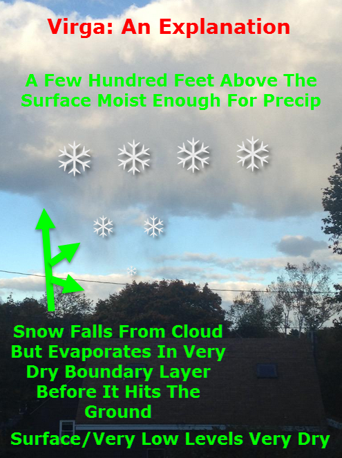
I tweeted this afternoon about a neat phenomenon I observed known to the weather community as virga. Very cold air aloft and some slight daytime heating at the surface combined to create some instability clouds/showers today across the area. Many areas saw their first flakes today but here in Yarmouth, extremely dry air at the surface prevented any flakes from making it to the ground though plenty were seen falling high above.
Virga occurs when precipitation falls out of a cloud into a very dry atmosphere below the cloud. The precip then evaporates leading to a dry surface while a healthy shower occurs above. This phenomenon creates a neat visual effect similar to a paintbrush running out of paint mid stroke as the precip gradually fades away.
Here are some more pictures of the Virga here in Yarmouth.
Another chilly night is on the way so keep fragile plants indoors through tomorrow.
Our storm is moving out this morning and most of the accumulations are done with the exception of NE areas where heavy snow bands will continue for another few hours. For the rest of us, some dry air at around 10,000 feet is causing precip to shut off and thus most of southern Maine is now dry.
That’s not to say precip is completely done, the upper low is only just beginning the process of moving through the area and everyone will likely see another round of snow this afternoon as it finishes its crossing.
HRRR Model Simulated Radar Animation. Credit: Weatherbell
Here is the HRRR model showing one more round of snow this afternoon before the storm moves out for good. Expect these snow showers/squalls to be heaviest between 1 and 6 PM this evening before moving out around 8 or 9 PM tonight.
Temps will be falling today starting in the 30’s this morning and crashing through the 20’s this evening. The mountains will likely see readings in the 10’s while the coast likely stays in the 20’s.
Another storm is on the way this weekend and while much of the Northeast US sees rain and 40’s for this storm, we lucky Northern New Englanders will likely be seeing more snow. While this will not be a big storm by any means, especially compared to others this winter, it will put a temporary pause on the arrival of Spring.
Water Vapor Image From This Afternoon Showing The Two Features That Will Bring Snow To The Area This Weekend. Credit: SSEC
Looking at the setup for our weekend system, two main features present themselves: a plume of moisture and warm air heading north from the Gulf Of Mexico and an Arctic disturbance racing SE to meet the moisture. How much cold makes it south and how far it gets will be crucial to determining how much snow falls.
12Z GFS Valid At 1 PM Tomorrow Showing Warm Air Streaming In At 2500 Feet. Credit: Accuweather
Before precip even starts, SW winds aloft will be allowing warm air to stream into southern parts of the region resulting in very little snow on the front side of the storm. Winds aloft are far weaker inland and thus above freezing air should be mainly a coastal issue with the foothills briefly getting in on the action tomorrow afternoon.
12Z NAM Showing Warm Air Working In Aloft But Staying Firm At The Surface. Vertical Temp Profile For Augusta, Valid At Midnight Tomorrow. The Red Line Indicates The Temperature.
Warm air will also be working in at the surface but with 1-3′ of snowpack still on the ground, warming aloft may outpace the warming at the surface tomorrow morning so a brief period of sleet/freezing rain is possible along the coast and just inland as well. While this doesn’t look like a major concern, watch out for some extra slick spots tomorrow morning.
12Z GFS Showing A Lack Of Intense Upward Motion Resulting In A Lack Of Heavy Precip. Image Credit: Accuweather
Another key difference between this storm and others this season will be that precip this time around will be a lot more on the steady side rather than extremely heavy. The GFS vertical velocity map above shows this well. Notice the lack of pinks/reds and the introduction of more gentle oranges. This translates to light to moderate precip rather than heavy precip.
Expected Precipitation Type For This Storm
By tomorrow afternoon, the warm air will have made its farthest push inland with temps both above freezing both aloft and at the surface all the way into the foothills. During the heaviest rain, flooding could be an issue along the coast where rain and snowmelt could combine to cause some minor street flooding Saturday afternoon/evening. Any impacts from flooding should be minor but it is something to watch for especially along the coast.
12Z GFS Showing A Strong Upper Low That Will Help To Extend Snow Well Into Sunday. Credit: Accuweather
The final phase of the storm will come Sunday as an upper low dives SE across the area. This will help to continue snow across the area on Sunday which is when coastal areas see most of their accumulations. Flakes will be flying as far south as SE MA but no accumulation is expected south of Boston.
12Z Canadian Model Showing Snow Lingering Into Sunday Afternoon. Map Valid 1 PM Sunday. Credit: Weatherbell
Snow on Sunday will be lighter and more showery in nature but it will help to keep roads slick and flakes falling for most of another day.
Taking a look at accumulations, the highest totals will be in the mountains where the cold air will hang tough the whole way through. Amounts drop off towards the coast with Southern New England seeing no accumulation at all.
Today will feature clouds on the increase as high pressure slides offshore and low pressure begins to approach from the west. Expect at least some sun to start this morning, especially over eastern areas, but everyone clouds up from west to east this afternoon. Precip will not be an issue until tomorrow with the exception of the mountains where a passing flurry or snow shower is possible. Accumulations will be a dusting at most. There is the chance that a few stray flakes make it to the foothills as well but no accumulations are expected. Highs today will range from low 20’s in the north to low/mid 30’s in the south and along the coast.
Another storm is headed our way this weekend, I’ll have another post detailing its timing and impacts this evening.
More quiet weather is on tap today as high pressure remains in control. Temps will rise into the 20’s for most with a few low 30’s along the coast. Today will start sunny but expect a few more clouds by afternoon as a weak storm moves in. A few flurries are possible in association with the storm in the mountains but otherwise, clouds will be the only effect from this one.
No other storms are in sight.
*Programming note: You may have noticed this update was out a little later than usual. The next two weeks are my spring vacation and I will still post every day, just a tad later as sleeping in felt really nice this morning. Late updates will continue through the 23rd when school starts again.