Tag Archives: flooding

Strong To Severe Storms Possible Tomorrow

Hello everyone!

Unfortunately I don’t have a ton of time for a full update this evening so I’ll save analysis of this weekend’s rain threat for tomorrow morning’s post. In this post I’ll look at tomorrow’s severe weather threat.

Current (6:00 PM) Obs Verifying Today's Forecast
Current (6:00 PM) Obs Verifying Today’s Forecast

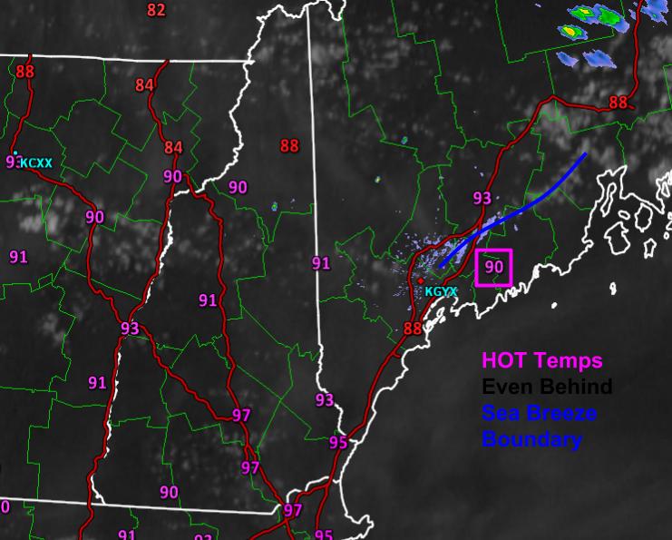
Today’s forecast worked out pretty well. Mostly sunny skies were reported across the area with only some high thin clouds to make a feeble attempt at blocking the sun. Temps soared as forecast into the 90’s almost everywhere. Even behind the sea breeze front, temps were near or over 90. Dew points dropped slightly, as forecast, as the atmosphere mixed out but it still felt quite stifling. Ready to do it again tomorrow except with even more humidity?

12Z GFS Showing The Plume Of Tropical Moisture Pointed Right At Us Tomorrow.

The plume of tropical moisture, believe it or not, was sitting just to our south today. The humidity you felt was mostly due to yesterday’s rain. Tomorrow, however, the full force of the tropical airmass will be pointed right at us and dew points will soar into the 70’s and stay there right on through the day (there is simply too much moisture in the air tomorrow to mix out like today). Meanwhile, a cold front will be approaching from the NW and an upper level disturbance will be moving into the area from the west (right black line on W edge of blue). The front and the disturbance will act as a trigger for some storms tomorrow. See those PWATs >2″ (blue colors) over coastal areas? Those PWATs, 3 standard deviations above the mean and in some cases never before seen in GEFS climatology, will provide plenty of fuel for downpours. Will there be any fuel for other severe weather? Absolutely.

12Z 4km NAM Showing Plenty Of Fuel For Storms Tomorrow. Image Credit: Weatherbell

As temps soar into the 90’s again tomorrow, the atmosphere will become quite unstable. CAPE values in excess of 1,500 j/kg will support strong storms, some of which could be strong enough for gusty winds. The atmosphere looks far too warm for significant hail but as a result of all the moisture, the atmosphere will be primed for a tornado or two. They look weak at this point but be prepared to seek shelter if you do come under a tornado warning. Also have a plan to be notified of that tornado warning if it’s issued for your area. Again, this is by no means a tornado ‘outbreak’ but one or two spinups are possible.

12Z GFS Showing Sufficient Shear For Storm Organization. Image Credit: Accuweather

The final ingredient, the organizer, looks not fantastic but good enough for at least some severe storms. 0-6km shear between 20 and 40 knots isn’t fantastic but it does raise the isolated severe storm red flag. The most important thing to note about tomorrow’s storm setup is that the biggest threats will not be gusty winds or hail or tornadoes. The biggest threat will be intense lightning and very heavy rain that could lead to flash flooding. It’s been so dry that the soil has ‘forgotten’ so to speak how to absorb moisture. This means that any heavy rain that suddenly falls will run right off and into the nearest road/ditch, some of which won’t be able to handle the large volume of water at once. Remember, turn around don’t drown and when thunder roars, go indoors.

I’ll be back tomorrow morning with a full update on both the severe weather threat and the heavy rain threat this weekend.

-Jack

Increasing Clouds Today As Yet Another Storm Approaches

Hello everyone!

Today will feature increasing clouds in advance of our next storm system approaching from the west. Expect sun this morning with clouds rolling in during the lunchtime hours. Highs today will range from the low 20’s up north to near 30 in the south. Snow should wait until the late evening hours before moving into Maine though SW NH could see flakes as early as 3 or 4 this afternoon.

snow map 3-3

Here is my thinking as to snow accumulations for this event. Watch out for a little ice in southern areas as above freezing air moves in aloft but the deep snowpack keeps the cold locked in at the surface. Warm air does look to move in at the surface down in the Boston area before the precip shuts off so watch for a period of heavy rain tonight which could cause some localized street flooding given all the snow on the ground.

No other storms are in sight as of now.

-Jack

Rainy Sunday

Hello everyone!

Today will feature mostly cloudy skies and warm temps with highs rising well into the 40’s. Any rain from our approaching system should hold off until late afternoon for southwest areas and for everyone else, any precip arrives after dark.

Tonight, rain moves in and becomes steadier and heavier as our storm begins to develop. Expect light NE winds as this storm will not be very strong nor will it be intensifying all that fast.

Tomorrow features heavy rain and breezy conditions. Expect highs in the low 40’s. Rain should become lighter as the afternoon progresses but as I will explain below, precip could hang around until midweek.

Monday through Wednesday will feature light to moderate rain/freezing rain/snow even at the coast. I expect Sunday night into Monday morning to be the worst in terms of icy conditions.

Late week we clear out and warm up into the upper 40’s under sunny skies. More rain/freezing rain/snow is possible next weekend but there are still a lot of details to be worked out.

Keep in mind, the storm could stall far enough offshore to get sunny and upper 40’s starting Monday or Tuesday. This is a very finicky pattern so keep in mind that is a possibility though don’t expect it.-

As spring arrives and warm and cold air battle it out over the US, we often get low pressure systems that are ‘cut off’ from the rest of the jet stream. They will meander around extremely slowly (anyone could out-jog them fairly easily) while bringing rainy/snowy weather to whichever area they happen to be in.

This is the kind of setup we will be stuck with over the next 5 days. The low will stall off Cape Cod and sit there with no interest in moving an inch. As a result, prolonged periods of rain and freezing rain are expected. It looks like the mountains will be too far away to get any more snow but that is also a possibility just as no precip is.

Expect QPF (Quantitative precipitation forecast which is the amount of liquid forecast to fall from the sky. Usually 1″ of QPF is 12″ of snow) amounts around an inch for the mountains and between 2 and 3 inches at the coast. This will fall starting this afternoon into tonight and last until Tuesday or Wednesday.

I think that the majority of that will fall as rain for the coast but starting Sunday evening, a flip to freezing rain is likely. I expect freezing rain amounts to be between 1/4″ and 1/3″. I will go into more detail below.

Impact map 3-29

Zone 1: Heavy snow. Snowfall amounts between 12 and 18″ with 24″ amounts possible. Expect snow to start tonight and end tomorrow night. Winds out of the NE at 10-15 mph. Temps in the low 30’s.

Zone 2: Heavy snow with a little rain possible. Snowfall amounts between 6 and 12″ Expect snow to start tonight and end Monday. Winds out of the NE at 10-15 mph. Temps in the low to mid 30’s.

Zone 3: Rain/freezing rain with a little snow. Snowfall amounts between 2 and 6″. Freezing rain amounts between 1/4 and 1/3″ Expect snow to start tonight and change to snow tomorrow before turning back to snow Monday.  Precip ends Monday or Tuesday. Temps in the low to mid 30’s.

Zone 4: Rain with some freezing rain. Freezing rain amounts between 1/4 and 1/3″ Expect rain to start tonight and possibly extend through Wednesday. Rain amounts 2-3″. Temps in the 40’s tomorrow falling into the 30’s tomorrow night through Tuesday/Wednesday.

Zone 5: Rain. Rain amounts 1-3″ higher amounts in the NE sections. Along the Maine coast, freezing rain is possible Monday through Tuesday/Wednesday. Precip ends Tuesday/Wednesday.

I am concerned about flooding because there is a heck of a lot of water locked up in the snow in the foothills and mountains. In areas forecast to get 2-3″ of rain, up to 10″ is locked away in the snow. Not all 10″ will melt but there are sure to be problems with this kind of a setup.

SWE 3-29

This map shows how much water there is in the snow. Click to enlarge.

As hard as it is to believe, there are still ice jams on the rivers left over from the January thaw. When new water flow into rivers already ice-jammed, minor flooding is likely.

Most of the area is under a flood watch from the NWS with the exception of far northern areas which are under a winter storm watch.

After this storm, warm and mild conditions are locked in place as we sit under high pressure. However, all good thing must come to an end as wet weather threatens for next weekend.

-Jack