Less than a week after signing off from historic Sandy, I am back on with a new storm and new situation. This WILL NOT be another Sandy! I can not stress this enough. This storm will likely bottom out at 985mb. This is a measure of barometric pressure. Sandy was 945mb. Sandy was a hurricane while this will be a typical nor’easter.
This storm will be affecting Florida on election day likely causing some voters to stay home but that is another issue. The storm will come up the coast Wednesday affecting the mid-Atlantic areas. The storm will bring winds of 40-50mph winds and a surge of 2-5′ rainfall totals of 2″ will be common. This will not be a major storm though its impacts will be more damaging due to the fact that Sandy weakened our defenses both physical (seawalls, dunes) and socially (our red cross and other agencies like FEMA are already very busy with Sandy damage and power crews still face more than 1 million outages). This will just add insult to injury after a historic Sandy. Thursday the storm will stall off of the Jersey coast and slowly weaken as it moves to the NE thursday night.
Snowfall is the tricky part to the forecast. There will be accumulating snow in the Catskills and the Whites with amounts possibly reaching a foot in the favored upslope regions. NJ, DE, and Eastern PA will see wet flakes though amours will be minor and uncirten
-Jack
The 2PM intermediate advisory has come out now and there are very few changes from before. The winds and pressure have stayed the same while the forward motion has increased to 14mph. There is also some new bouy data to show. I will feature 4 bouys. 1 off of Cape Hatteras, one in New York Harbor, one in the Gulf Of Maine, and one off the Jersey coast.

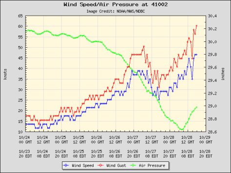
Station 41002 NDBC
Location: 31.862N 74.835W
Date:Sun, 28 Oct 2012 17:50:00 UTC
Winds: NW (310°) at 46.6 kt gusting to 60.2 kt
Significant Wave Height: 27.9 ft
Dominant Wave Period: 10 sec
Mean Wave Direction: NNW (337°)
Atmospheric Pressure: 28.98 in and rising
Air Temperature: 70.9 F
Water Temperature: 77.9 F
Bouy 41002 Off of the Carolina Coast.

Station 44065 NDBC
Location: 40.369N 73.703W
Date:Sun, 28 Oct 2012 17:50:00 UTC
Winds: NE (40°) at 25.3 kt gusting to 29.1 kt
Significant Wave Height: 9.5 ft
Dominant Wave Period: 9 sec
Mean Wave Direction: ESE (120°)
Atmospheric Pressure: 29.70 in and falling rapidly
Air Temperature: 59.0 F
Dew Point: 54.1 F
Water Temperature: 61.2 F
Bouy 44065 in New York Harbor.
Station 44005 NDBC
Location: 43.204N 69.128W
Date:Sun, 28 Oct 2012 17:50:00 UTC
Winds: ENE (60°) at 13.6 kt gusting to 15.5 kt
Significant Wave Height: 5.6 ft
Dominant Wave Period: 6 sec
Atmospheric Pressure: 29.96 in and falling
Air Temperature: 52.5 F
Dew Point: 52.5 F
Water Temperature: 55.0 F
Bouy 44005 off of Portland ME.
Station 44025 NDBC
Location: 40.250N 73.167W
Date:Sun, 28 Oct 2012 17:50:00 UTC
Winds: NE (50°) at 31.1 kt gusting to 36.9 kt
Significant Wave Height: 12.8 ft
Dominant Wave Period: 11 sec
Mean Wave Direction: SE (146°)
Atmospheric Pressure: 29.67 in and falling
Air Temperature: 58.6 F
Dew Point: 56.5 F
Water Temperature: 61.9
Bouy 44025 off the Jersey coast.
Enjoy the data! I will make a new post with updated bouy data/new advisories at around 8 or 9 tonight.
-Jack
Reliably hype-free weather info for Western Maine and New Hampshire from amateur forecaster Jack Sillin


