Tag Archives: mountains

Neat Weather Tidbit: The Mysterious Midnight Temp Spike

Hello everyone!

PWM Temperature Graph Showing An Abnormal Spike In Temps At Around 8:30 Last Night.

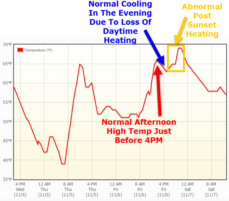
Last night between 8 and 9 PM, something really cool happened all across southern Maine. Several hours after dark and following the passage of a cold front, temps spiked between 4 and 6 degrees in less than an hour going against all logic that temps should fall after dark especially without any large scale weather system to draw warm air north. Let’s see what happened.

8PM Surface Analysis Off The SPC Mesoanalysis Page Showing A Cold Front Stretched Across The Area.

At 8:00 last night, a cold front was crossing the area from west to east with SW winds ahead of it and W winds behind it. Temps were already pretty warm, in the 60’s, as southerly winds ahead of the front brought warm air into the region. Colder air lurked behind the front and temps in the 30’s were being reported in the upper Great Lakes with west winds bringing those temps right to us. So what happened? Shouldn’t temps have dropped after the passage of a cold front with an actual cold airmass behind it?

A General Explainer Of Upslope/Downslope Winds In Maine. All Crude Graphics Design Credit Goes To Me.
A General Explainer Of Upslope/Downslope Winds In Maine. All Terrible Graphics Design Credit Goes To Me 🙂

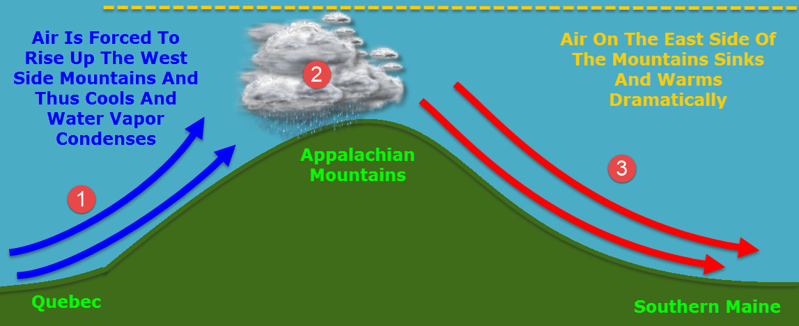
The answer lies in downsloping. This is a term I’ve used a lot but really want to explain here. Winds after the cold front were

westerly/northwesterly and thus the air over southern Maine came from New York/Quebec and then up and over the Appalachian Mountains. When the air rose up the west side of the Appalachians, it cooled but not a lot of the moisture was rung out as shown by the lack of precip at the time.

Because the air was still pretty saturated at the time, the sinking air on the east side of the mountains warmed at the saturated adiabatic lapse rate of roughly 5.5F for every thousand feet. The 5.5 degrees per 1,000 feet figure is for fully saturated air with relative humidity of 100%. The relative humidity in Portland at the time was 73% so the air could be expected to warm at 73% of the moist (partially saturated) adiabatic lapse rate. 73% of 5.5 degrees is 4.015 degrees, very close to the 4 degree rise measured at PWM.

At Augusta, the same calculation works. The temperature rose 5 degrees from 59 degrees at 9 PM to 64 degrees at 11PM. With a relative humidity at 9PM of 90%, that works out to a moist adiabatic lapse rate of 4.95 degrees, again, darn close to the 5 degrees observed in actuality.

0Z (7PM) Sounding From Gray Shoiwng Very Warm Air Just Above The Surface. Credit: SPC
0Z (7PM) Sounding From Gray Showing Very Warm Air Just Above The Surface. Credit: SPC

Another contributing factor to the suddenness of the spike in temps was warm air aloft suddenly being mixed down to the surface. The 7PM sounding up in Gray showed warm air just above the surface which promptly mixed down with the turbulence caused by the passage of the front.

The air just above the surface was being downsloped to just the right temperature with westerly winds just above the surface and when the surface front came through, the turbulence broke the inversion and sent those warm temps crashing to the ground.

I’ll be back in the morning with tomorrow’s weather. A sneak peek reveals cooler but still not chilly temps in the 50’s with mainly sunny skies.

-Jack

Quiet 7-day outlook

No need to go into detail for any of the days in the 7-day outlook. The forecast simply is sun with a few clouds highs ranging from 29-37 in southern ME and take off a few degrees and you get the temps for the north and mountains. Add a few degrees to get southern NE temps. Mid atlantic: rainy for Superbowl sunday with temps generally in the 40s through the 7-day.

Stay tuned!

-JAck

Snowy update

UPDATE: 1:45pm EST curent observations show a bout 4″ have already fallen here in Yarmouth with higher totals WSW of here. Another 4-8″ is expected bringing the forecast totals to a little less than a foot at the coast with higher amounts inland and in the mountains. Temperatures will warm to about 31 before dropping. Tonight will feature freezing rain amounting to around .15-.25″ travel will be tricky if not outright dangerous until around 3:00 tomorrow.

Stay tuned!

-Jack

Winter storm tomorrow

Wednesday 5:00: Forecasts have shifted dramatically this past week. Just 1 week ago the forecast was 50 and rain, now it is 33 and snow with freezing rain for Friday. There is some tricky parts in the forecast though. It looks like there will be a strong temperature difference between about 100 yards from the shore where the high will be around 32 or 33 and snow while even 100 yards offshore where highs will be in the upper 30s and rain. Amounts: islands and tips of peninsulas……………1-3″  Coast ( within about 1 mile of the water ) 4-6″   inland  8-12″ and mountains……………..7-9″. More updates in coming hours.

Stay tuned!!!

-Jack

Thursday storm update

Tuesday 6:00 pm: New updates coming in this evening showing that this storm will bring some welcome relief from the “snow drought” this season. This system will be a classic Nor’easter with a stiff NE wind throughout the day thursday. This NE wind will bring a possible mix at the immediate coast ( Islands and tips of peninsulas ) and southern sections of ME and NH. Early snowfall estimates go as following:      Coast………….3-6″
Inland………….4-8″
Mountains………….around 1′

Stay tuned!

-Jack