If you need something to cheer you up on yet another bitterly cold morning, a sizeable storm missed us. The storm that brought snow and ice to the deep south will be passing by well offshore and the only impacts we will see will be an increase in clouds especially over southern areas. Areas SE of Boston will get in on some snow accumulating 1-3″. Temps will be cold but not frigid, in the 10’s up north with 20’s south.
6Z RGEM Model Showing A Storm Missing To Our South This Afternoon. Credit: Weatherbell
Clouds clear out tonight as the storm moves away and sunny but cold conditions look to make a return for tomorrow and into the weekend.
No significant storms are on the horizon as of now but no significant warmups are either.
Clouds will be on the increase today as yet another storm approaches from the west. Expect a very chilly start with most areas seeing double digits below zero this morning. However, temps will warm swiftly during the day as light southerly winds bring in warmer air. Most of us will end the day in the 10’s to low 20’s.
Snow will begin in the afternoon hours and will spread east during the evening. Expect a light snow for most areas with some moderate bands working their way in along the coast in the evening hours. Inland areas see mainly a dry and fluffy snow though some wetter snow is possible early tomorrow morning. Coastal areas see heavy wet snow and then have a shot at some rain too. This combined with the snow we’ve already had this winter will put a tremendous load on roofs so please shovel your roofs off today.
HRRR Model Showing Snow Approaching From The West This Morning Before Spreading Across The Region This Afternoon. Credit: Weatherbell
By evening, everyone is seeing snow, moderate at times, with temps slowly rising through the 20’s. It will be a race between the departing precip and the warming temps to see who gets rain. Most of the precip is out of here by midmorning tomorrow and only the islands/peninsulas should see rain by then.
Almost everyone goes above freezing for the first time in quite a while tomorrow afternoon after the ‘cold’ front comes through and shifts winds to the west. This will act to mix out the cold air that is in place and thus cause temps to rise. This is because the cold air that is in place during the storm is allowed to be in place because the air is not all that turbulent. The air from 10,000 feet is not going down to 5,000 feet and vise versa. Only when the front comes through and the air is moving up and down as well as horizontally can you bust open the cold dome that is in place.
Here is my thinking as to snowfall accumulations. On the south side of the 3-6″ zone accumulations will be limited by mixing with rain/freezing rain. It should be noted that since ground temps are so cold, any rain that falls will freeze on exposed surfaces like plowed roads or driveways so beware of icy spots if rain falls.
Quick mid-storm update this morning and all systems are go as far as the forecast is concerned. Heavy mesoscale bands are producing intense snowfall rates of 2-4″ per hour and storm to sometimes hurricane force wind gusts (50-80 MPH) are blowing all that snow around. Yesterday’s maps and analysis still stands so refer back to last night’s blog post for those details.
Here is a look at the radar as of 10:00 this morning showing several areas of enhanced snowfall. Our next intense band is strengthening offshore and will bring more intense snowfall rates to the area this afternoon. Even in areas outside of the heaviest bands, snowfall rates are still in the 1-2″ per hour range.
Expect continued blizzard conditions through the afternoon and evening before snow becomes lighter tonight. Steady snow will end tomorrow morning before tapering off to snow showers. Colder air will arrive on NW winds tomorrow so expect continued blowing and drifting which could cause locally reduced visibilities and dangerous road conditions even though snow will no longer be falling.
Our next chance for widespread snowfall arrives Friday but it should not be a major event. More details once this storm ends. Yet another storm threat arrives early next week.
I’ll be back tomorrow morning with the usual AM update.
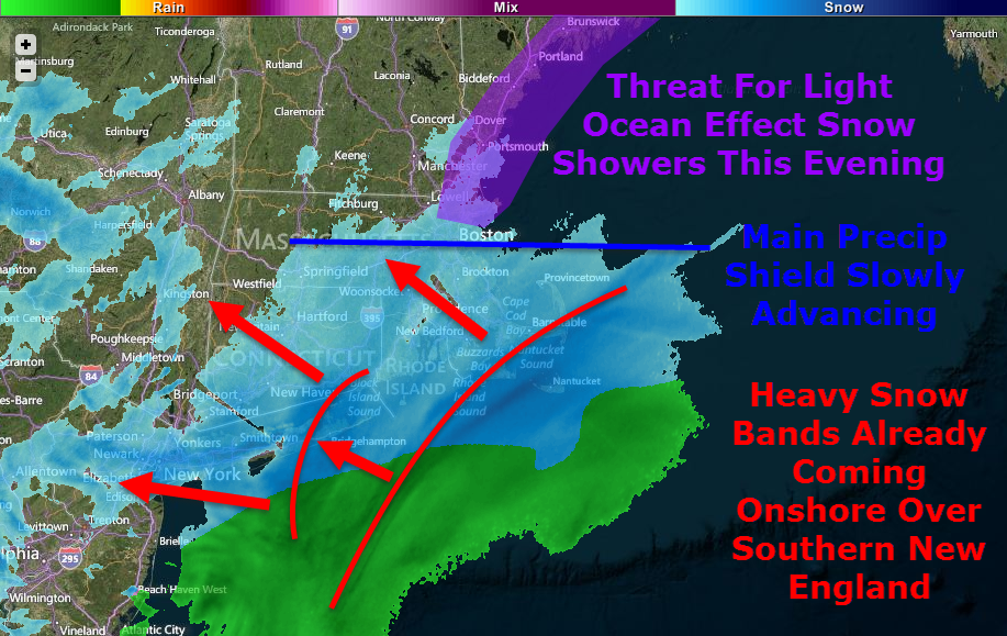
It’s here, go time, T-0. Heavy snow is already moving onshore across southern New England as light ocean effect snow showers organize across coastal Maine and New Hampshire. The main precip shield, as of 5:30, is located just north of Boston extending almost due west and is slowly moving north.
While I try to keep things under control in the technicality department, some higher level terms will be thrown around. Any words that show up in green, signaling a link, will take you to the glossary I have compiled with more information. Suggestions are welcome regarding terms you would like to see added to the glossary.
A busy water vapor satellite image shows well the components of our storm coming together. This is really a textbook storm with high latitude blocking, a strengthening low at all levels of the atmosphere, a deep tropical connection, and more reserve energy waiting to drop into the storm up in the Great Lakes. The storm’s strong baroclinic leaf consists of the broad blue area from Maine to Maryland and offshore. Just how many and how far-reaching will the impacts from this storm be? Hint: there are quite a few and they will cover all the bases.
Snow
Lots of snow is expected with this one, no doubt about it. Widespread 1-2′ amounts are expected with slightly less in the far north and along the cape while areas west of Boston stand the greatest chance for over 2′ to as much as 3′ of snow.
There are a few reasons for such high snowfall totals, first, this will be a rapidly strengthening storm. pressure is already falling fast off the Carolina coast and the low is quickly gaining steam. When you have a rapidly intensifying storm, you get intense upward motion on the NW side which brings very heavy snow.
This map is the NAM vertical velocity map for 7AM tomorrow showing an intense band of snow along coastal Maine. This band will later move inland bringing heavy snow all the way to Canada. In areas highlighted in pink, extreme snowfall rates on the order of 1-3″ per hour will be widespread along with enhanced winds along with the potential for thundersnow. Image courtesy, Accuweather.
Another reason for high snowfall totals will be the dry, fluffy nature of the snow which can accumulate very efficiently. Temps in the single digits to low teens will keep snow dry and powdery for the duration as well as keep the threat for mixing well to the south and east.
One last contributing factor to mention is the fact that the storm will stall out southeast of Nantucket for about 12 hours tomorrow and will keep rotating heavy bands onshore through the entire day rather than skirting right out to sea. With many hours of heavy, efficiently accumulating snowfall, amounts will approach or even exceed 2 feet in many areas.
Wind
Wind Gusts In Knots Off The 12Z GFS. Courtesy: Accuweather
With a rapidly intensifying low to our SE and a strong, stubborn high to our NW, the pressure gradient will be extremely tight. Wind gusts exceeding 60 mph are likely along all of coastal ME and NH extending all the way through Eastern MA, RI, and Eastern CT. Coastal SE MA will likely see wind gusts over hurricane force Tuesday morning. Inland areas will see wind too, though less violent than coastal areas. Gusts exceeding 35mph will be common region-wide.
Winds this strong, no matter the circumstance, will bring down tree limbs and power lines so power outages are a very real threat across coastal areas. The power outage threat will extend inland though will be mitigated somewhat by friction and thus lower wind speeds.
Blowing/Drifting Snow, Blizzard Conditions
Official Warning Map From NWS Gray Showing Blizzard Warnings Along The Coast With Winter Storm Warnings Inland
The combination of high winds and powdery snow will cause extended whiteouts across coastal areas on Tuesday. For this reason, the NWS has issued Blizzard Warnings for the coast as well as adjacent inland areas. To qualify as a blizzard, a storm must produce falling or blowing snow combined with winds of over 35 mph reducing visibilities to 1/4 mile or less. All these criteria must be met for 3 hours or more to qualify. All areas should expect scattered blizzard conditions but the coast is likely to meet the official criteria for a blizzard event.
With such high amounts of snow forecasted combined with high winds, drifting will also become a legitimate concern especially for those areas in the blizzard warning. Drifts up to 4 feet are possible in some highly localized areas with other spots seeing bare ground as the snow is blown somewhere else.
Coastal Flooding
A prolonged period of strong onshore winds almost always results in coastal flooding and this time is no different. The map above is off the Wave Watch III model, courtesy of Accuweather, which shows 24 foot seas just offshore. While the more northerly component of the storm will mitigate the threat somewhat, the coast will take a bit of a beating for sure.
For these reasons, the NWS has issued a Coastal Flood Warning for the entire coast which I totally agree with due to the expected 1-4 foot storm surge plus the strong wave action. Expect moderate to, in some places major coastal flooding with the high tides on Tuesday. Things will settle down somewhat Wednesday though some residual wave action may cause some minor problems.
Timing/Travel Impacts
Below I will break down the timing along with travel impacts. The scale for travel impacts goes Minor, Moderate, Major, Severe, Extreme, Extreme Do Not Travel. If you must travel, always consult the latest NWS information.
Tonight – Snow builds in from South to North becoming heavy at times later on tonight. Travel impacts: Moderate.
Tomorrow Morning – Very heavy snow bands rotate in off the ocean causing extremely heavy snow which, combined with high winds, will cause travel to become impossible. Travel impacts: Extreme. Do Not Travel.
Tomorrow Afternoon – Heavy snow sticks around though the extreme snow moves out. Winds will still be whipping causing continued whiteout conditions. Travel impacts: Extreme.
Tomorrow Night: Heavy snow moves out, steady moderate snow remains. Winds die down slightly though whiteout conditions can still be expected. Travel impacts: Severe
Wednesday Morning: Light, but steady snow remains with some moderate bands. Winds will continue to die down but blowing and drifting will remain an issue. Travel impacts: Major/Moderate
Wednesday Afternoon: Steady snow moves out leaving patchy snow showers/squalls. Winds however will keep the threat for blowing and drifting snow around long after the flakes stop falling. Travel impacts: Moderate.
Wednesday Night: Clearing begins, some blowing/drifting still possible mainly in the evening as winds continue to let up. Travel impacts; Minor.
Recap
All in all, this will be a big storm, but probably not record-breaking at least for Maine. Widespread 1-2′ amounts are likely with the bullseye for 2’+ being west of Boston. Highs winds will whip the snow into a frenzy and cause blowing and drifting along with whiteout conditions. The peak of the storm will be Tuesday, especially in the morning. Snow slowly winds down Tuesday night before ending midday Wednesday.
I’ll be back tomorrow morning with another update.
Today will feature mostly cloudy skies and warm temps with highs rising well into the 40’s. Any rain from our approaching system should hold off until late afternoon for southwest areas and for everyone else, any precip arrives after dark.
Tonight, rain moves in and becomes steadier and heavier as our storm begins to develop. Expect light NE winds as this storm will not be very strong nor will it be intensifying all that fast.
Tomorrow features heavy rain and breezy conditions. Expect highs in the low 40’s. Rain should become lighter as the afternoon progresses but as I will explain below, precip could hang around until midweek.
Monday through Wednesday will feature light to moderate rain/freezing rain/snow even at the coast. I expect Sunday night into Monday morning to be the worst in terms of icy conditions.
Late week we clear out and warm up into the upper 40’s under sunny skies. More rain/freezing rain/snow is possible next weekend but there are still a lot of details to be worked out.
Keep in mind, the storm could stall far enough offshore to get sunny and upper 40’s starting Monday or Tuesday. This is a very finicky pattern so keep in mind that is a possibility though don’t expect it.-
As spring arrives and warm and cold air battle it out over the US, we often get low pressure systems that are ‘cut off’ from the rest of the jet stream. They will meander around extremely slowly (anyone could out-jog them fairly easily) while bringing rainy/snowy weather to whichever area they happen to be in.
This is the kind of setup we will be stuck with over the next 5 days. The low will stall off Cape Cod and sit there with no interest in moving an inch. As a result, prolonged periods of rain and freezing rain are expected. It looks like the mountains will be too far away to get any more snow but that is also a possibility just as no precip is.
Expect QPF (Quantitative precipitation forecast which is the amount of liquid forecast to fall from the sky. Usually 1″ of QPF is 12″ of snow) amounts around an inch for the mountains and between 2 and 3 inches at the coast. This will fall starting this afternoon into tonight and last until Tuesday or Wednesday.
I think that the majority of that will fall as rain for the coast but starting Sunday evening, a flip to freezing rain is likely. I expect freezing rain amounts to be between 1/4″ and 1/3″. I will go into more detail below.
Zone 1: Heavy snow. Snowfall amounts between 12 and 18″ with 24″ amounts possible. Expect snow to start tonight and end tomorrow night. Winds out of the NE at 10-15 mph. Temps in the low 30’s.
Zone 2: Heavy snow with a little rain possible. Snowfall amounts between 6 and 12″ Expect snow to start tonight and end Monday. Winds out of the NE at 10-15 mph. Temps in the low to mid 30’s.
Zone 3: Rain/freezing rain with a little snow. Snowfall amounts between 2 and 6″. Freezing rain amounts between 1/4 and 1/3″ Expect snow to start tonight and change to snow tomorrow before turning back to snow Monday. Precip ends Monday or Tuesday. Temps in the low to mid 30’s.
Zone 4: Rain with some freezing rain. Freezing rain amounts between 1/4 and 1/3″ Expect rain to start tonight and possibly extend through Wednesday. Rain amounts 2-3″. Temps in the 40’s tomorrow falling into the 30’s tomorrow night through Tuesday/Wednesday.
Zone 5: Rain. Rain amounts 1-3″ higher amounts in the NE sections. Along the Maine coast, freezing rain is possible Monday through Tuesday/Wednesday. Precip ends Tuesday/Wednesday.
I am concerned about flooding because there is a heck of a lot of water locked up in the snow in the foothills and mountains. In areas forecast to get 2-3″ of rain, up to 10″ is locked away in the snow. Not all 10″ will melt but there are sure to be problems with this kind of a setup.
This map shows how much water there is in the snow. Click to enlarge.
As hard as it is to believe, there are still ice jams on the rivers left over from the January thaw. When new water flow into rivers already ice-jammed, minor flooding is likely.
Most of the area is under a flood watch from the NWS with the exception of far northern areas which are under a winter storm watch.
After this storm, warm and mild conditions are locked in place as we sit under high pressure. However, all good thing must come to an end as wet weather threatens for next weekend.
After an inactive start to the season, we are about to turn over a new page in the tropics. The main driver will be the Madden-Julian Oscillation, a pattern of shifting winds that increases thunderstorm growth that returns to the same area every 30-60 days. This pattern will make itself known later this week into this weekend and will continue through mid September. For those of you who follow tropical weather, we saw this pattern in the Central Pacific and the Eastern Pacific these past few weeks which was why there was so much activity there. (2 storms in a week in the Central Pacific is VERY active) We already have a few interesting African Waves to look at…
Our 2 African waves that need to be watched. More are expected to arrive from Eastern Africa over the course of the next few weeks.
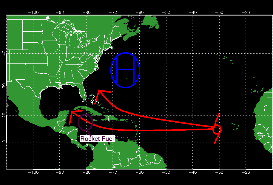
Another unusual thing about this particular MJO pulse if there have only been 2 of this extreme caliber in recent memory. In those 2 cases, 68% or 21 out of 31 depressions formed into hurricanes. The models are already excited showing nearly every wave evolving into a system. Most of which will recurve due to a high pressure system that usually steers it into the Caribbean being too weak to have the westward effect on storms.
The position of the Bermuda high is further westward and weaker allowing strong storms to recurve easily out to sea.
However, if a storm is weak enough it will continue westward into the Caribbean where so called “rocket fuel” is located allowing for rapid intensification under the right circumstances.
This map depicts a possible track for a weak storm that can continue westward despite the position of the high.
This map shows where the most possible energy is for a tropical system to feed on.
I believe the last time a storm traversed this area was in 2008, 5 years ago when Gustav moved from the Western Caribbean into Cuba. This is also the same area where Wilma intensified into a monster 882 mb, 180 mph, cat 5 hurricane. The other danger that lies here is that any storm that forms and intensifies WILL affect land and has a 95% chance of making landfall somewhere. The good news is that no model currently forecasts a storm to develop here however its an important area to watch nonetheless.
A further update on the tropics can be expected in a few days or when a system develops or is a threat to develop.
What a change over the past few days! First we were looking at the potential for a foot of snow from a powerful ocean storm and now we are looking at 6″ from its wicked inverted trough. Remember that inverted or norlun trough from earlier this winter? They are impossible to predict where they will set up until they actually do set up. Now I am thinking it will set up right near Portland or maybe a little south. Either way, there should be snow breaking our today from “ocean effect” or lake effect snow but over the ocean. Ocean effect snow tends not to be as heavy as lake effect and that is what we will see today.
There is a developing low off the Carolina coast that is moving ENE. This low will skirt too far offshore to have too much of an effect. its norlun or inverted trough however will. This troughs are notoriously impossible to predict as we saw earlier this year. Right now my thoughts are that it will dump a sufficient amount (6″) to many across southern Maine. My snow map is below.
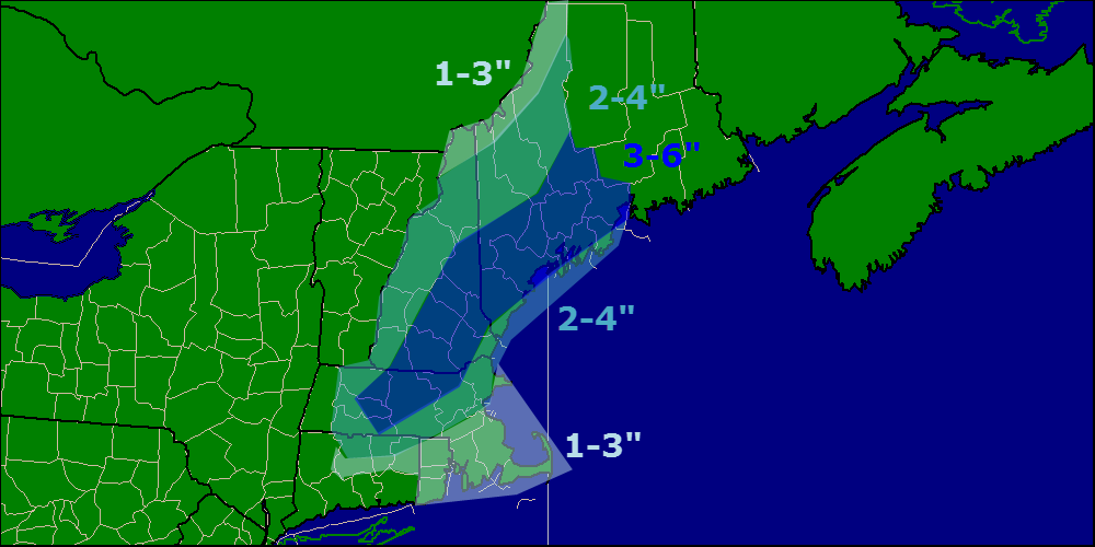
Snow map.
Check out my other two sites for town by town forecasts for the snow. Those will be updated with the 18z runs tonight. They can be found at the right of my page.
-Jack
Models now agree this morning that the comination or phasing of these two storms will occur too far to the south and east to give us much snow. I expect a widespread 4-6″ from an inverted trough. Remember what happened with that last time? We all expected 8-12″ but we got 0. These things are absolutely impossible to predict so confidence is super low. Snow map coming with 12z models midday.
The area of low pressure will develop and move to the ESE today into tonight. It will then rapidly deepen South of the Maritimes. The inverted or norlun trough will hang around behind giving us minimal snow. Check back later for the snow map.
-Jack
Snow will be falling today in NE as a warm front pushes north. The warm front will bring warm air and this will cause a mix at the coast and some light rain tomorrow. After that the forecast really becomes extremely unclear. Models like the idea of a coastal storm developing Friday or Saturday with an extremely large trough digging down through the eastern third of the country. Models have been backing off on that solution however there is a possibility to see a storm develop Monday.
NE will see some snow in the next few days. Todays snow will be focused in ME and NH however tomorrow will bring snow to NEs entirety. This will bring 2-4″ in ME and NH. MA will be in the 1-3″ range with RI and CT only seeing a dusting to 1″. More possible storms in the long range but due to huge model uncertainty, it is far to early to go into details.