Today will be an interesting one for sure as our storm pulls away. This morning expect clouds with a few lingering flurries mainly over Midcoast Maine as well as York County. Any leftover snow activity should be moving out in the next hour or two so the digging out can begin. Temps this morning are mild by comparison to previous weeks, 10’s inland and 20’s elsewhere with even a few 30’s showing up along the immediate coast!
Temps will warm even more today as a cold front comes through. Let’s just say the airmass behind the front isn’t all that cold… What the front does is basically slices and dices the cold airmass that is in place this morning so that it can move out of the way (notice the warm air that tried to work in last night was met with little success). As a result, temps will rise into the 30’s for everyone with readings near 40 along the coast!
For Portland, today will likely mark the first day since January 5th that the temperature has been at or above average.
NWS Radar Image Showing Snow Moving Out This Morning
Our mild temps today do not last as another cold front moves through this evening. Winds will pick up tonight as the cold air moves in and we go back to the bitter cold. Our next chance for snow arrives Wednesday and it looks to be in the form of snow showers or maybe even light snow.
Clouds will be on the increase today as yet another storm approaches from the west. Expect a very chilly start with most areas seeing double digits below zero this morning. However, temps will warm swiftly during the day as light southerly winds bring in warmer air. Most of us will end the day in the 10’s to low 20’s.
Snow will begin in the afternoon hours and will spread east during the evening. Expect a light snow for most areas with some moderate bands working their way in along the coast in the evening hours. Inland areas see mainly a dry and fluffy snow though some wetter snow is possible early tomorrow morning. Coastal areas see heavy wet snow and then have a shot at some rain too. This combined with the snow we’ve already had this winter will put a tremendous load on roofs so please shovel your roofs off today.
HRRR Model Showing Snow Approaching From The West This Morning Before Spreading Across The Region This Afternoon. Credit: Weatherbell
By evening, everyone is seeing snow, moderate at times, with temps slowly rising through the 20’s. It will be a race between the departing precip and the warming temps to see who gets rain. Most of the precip is out of here by midmorning tomorrow and only the islands/peninsulas should see rain by then.
Almost everyone goes above freezing for the first time in quite a while tomorrow afternoon after the ‘cold’ front comes through and shifts winds to the west. This will act to mix out the cold air that is in place and thus cause temps to rise. This is because the cold air that is in place during the storm is allowed to be in place because the air is not all that turbulent. The air from 10,000 feet is not going down to 5,000 feet and vise versa. Only when the front comes through and the air is moving up and down as well as horizontally can you bust open the cold dome that is in place.
Here is my thinking as to snowfall accumulations. On the south side of the 3-6″ zone accumulations will be limited by mixing with rain/freezing rain. It should be noted that since ground temps are so cold, any rain that falls will freeze on exposed surfaces like plowed roads or driveways so beware of icy spots if rain falls.
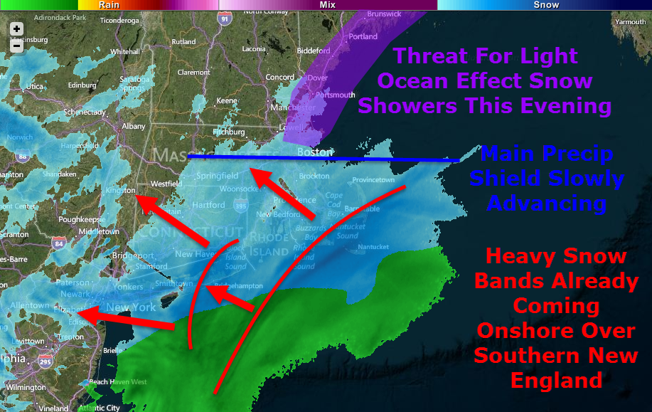
It’s here, go time, T-0. Heavy snow is already moving onshore across southern New England as light ocean effect snow showers organize across coastal Maine and New Hampshire. The main precip shield, as of 5:30, is located just north of Boston extending almost due west and is slowly moving north.
While I try to keep things under control in the technicality department, some higher level terms will be thrown around. Any words that show up in green, signaling a link, will take you to the glossary I have compiled with more information. Suggestions are welcome regarding terms you would like to see added to the glossary.
A busy water vapor satellite image shows well the components of our storm coming together. This is really a textbook storm with high latitude blocking, a strengthening low at all levels of the atmosphere, a deep tropical connection, and more reserve energy waiting to drop into the storm up in the Great Lakes. The storm’s strong baroclinic leaf consists of the broad blue area from Maine to Maryland and offshore. Just how many and how far-reaching will the impacts from this storm be? Hint: there are quite a few and they will cover all the bases.
Snow
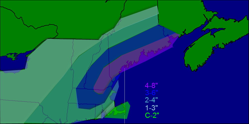
Lots of snow is expected with this one, no doubt about it. Widespread 1-2′ amounts are expected with slightly less in the far north and along the cape while areas west of Boston stand the greatest chance for over 2′ to as much as 3′ of snow.
There are a few reasons for such high snowfall totals, first, this will be a rapidly strengthening storm. pressure is already falling fast off the Carolina coast and the low is quickly gaining steam. When you have a rapidly intensifying storm, you get intense upward motion on the NW side which brings very heavy snow.
This map is the NAM vertical velocity map for 7AM tomorrow showing an intense band of snow along coastal Maine. This band will later move inland bringing heavy snow all the way to Canada. In areas highlighted in pink, extreme snowfall rates on the order of 1-3″ per hour will be widespread along with enhanced winds along with the potential for thundersnow. Image courtesy, Accuweather.
Another reason for high snowfall totals will be the dry, fluffy nature of the snow which can accumulate very efficiently. Temps in the single digits to low teens will keep snow dry and powdery for the duration as well as keep the threat for mixing well to the south and east.
One last contributing factor to mention is the fact that the storm will stall out southeast of Nantucket for about 12 hours tomorrow and will keep rotating heavy bands onshore through the entire day rather than skirting right out to sea. With many hours of heavy, efficiently accumulating snowfall, amounts will approach or even exceed 2 feet in many areas.
Wind
Wind Gusts In Knots Off The 12Z GFS. Courtesy: Accuweather
With a rapidly intensifying low to our SE and a strong, stubborn high to our NW, the pressure gradient will be extremely tight. Wind gusts exceeding 60 mph are likely along all of coastal ME and NH extending all the way through Eastern MA, RI, and Eastern CT. Coastal SE MA will likely see wind gusts over hurricane force Tuesday morning. Inland areas will see wind too, though less violent than coastal areas. Gusts exceeding 35mph will be common region-wide.
Winds this strong, no matter the circumstance, will bring down tree limbs and power lines so power outages are a very real threat across coastal areas. The power outage threat will extend inland though will be mitigated somewhat by friction and thus lower wind speeds.
Blowing/Drifting Snow, Blizzard Conditions
Official Warning Map From NWS Gray Showing Blizzard Warnings Along The Coast With Winter Storm Warnings Inland
The combination of high winds and powdery snow will cause extended whiteouts across coastal areas on Tuesday. For this reason, the NWS has issued Blizzard Warnings for the coast as well as adjacent inland areas. To qualify as a blizzard, a storm must produce falling or blowing snow combined with winds of over 35 mph reducing visibilities to 1/4 mile or less. All these criteria must be met for 3 hours or more to qualify. All areas should expect scattered blizzard conditions but the coast is likely to meet the official criteria for a blizzard event.
With such high amounts of snow forecasted combined with high winds, drifting will also become a legitimate concern especially for those areas in the blizzard warning. Drifts up to 4 feet are possible in some highly localized areas with other spots seeing bare ground as the snow is blown somewhere else.
Coastal Flooding
A prolonged period of strong onshore winds almost always results in coastal flooding and this time is no different. The map above is off the Wave Watch III model, courtesy of Accuweather, which shows 24 foot seas just offshore. While the more northerly component of the storm will mitigate the threat somewhat, the coast will take a bit of a beating for sure.
For these reasons, the NWS has issued a Coastal Flood Warning for the entire coast which I totally agree with due to the expected 1-4 foot storm surge plus the strong wave action. Expect moderate to, in some places major coastal flooding with the high tides on Tuesday. Things will settle down somewhat Wednesday though some residual wave action may cause some minor problems.
Timing/Travel Impacts
Below I will break down the timing along with travel impacts. The scale for travel impacts goes Minor, Moderate, Major, Severe, Extreme, Extreme Do Not Travel. If you must travel, always consult the latest NWS information.
Tonight – Snow builds in from South to North becoming heavy at times later on tonight. Travel impacts: Moderate.
Tomorrow Morning – Very heavy snow bands rotate in off the ocean causing extremely heavy snow which, combined with high winds, will cause travel to become impossible. Travel impacts: Extreme. Do Not Travel.
Tomorrow Afternoon – Heavy snow sticks around though the extreme snow moves out. Winds will still be whipping causing continued whiteout conditions. Travel impacts: Extreme.
Tomorrow Night: Heavy snow moves out, steady moderate snow remains. Winds die down slightly though whiteout conditions can still be expected. Travel impacts: Severe
Wednesday Morning: Light, but steady snow remains with some moderate bands. Winds will continue to die down but blowing and drifting will remain an issue. Travel impacts: Major/Moderate
Wednesday Afternoon: Steady snow moves out leaving patchy snow showers/squalls. Winds however will keep the threat for blowing and drifting snow around long after the flakes stop falling. Travel impacts: Moderate.
Wednesday Night: Clearing begins, some blowing/drifting still possible mainly in the evening as winds continue to let up. Travel impacts; Minor.
Recap
All in all, this will be a big storm, but probably not record-breaking at least for Maine. Widespread 1-2′ amounts are likely with the bullseye for 2’+ being west of Boston. Highs winds will whip the snow into a frenzy and cause blowing and drifting along with whiteout conditions. The peak of the storm will be Tuesday, especially in the morning. Snow slowly winds down Tuesday night before ending midday Wednesday.
I’ll be back tomorrow morning with another update.
Today will feature a cloudy start ahead of our next storm. Clouds will spread northward as the day goes on and snow will not be far behind.
Snow will overspread southern New Hampshire this morning between 7 and 8 and will move into southern Maine between 8 and 9. Snow will become heavy after noon and thunder could accompany the heaviest bands with snowfall rates approaching 3″/hr.
Snow will taper off this evening into tonight SW to NE as the low pulls away. Any leftover snow will end by 1-2 am. Expect winds to kick up once again as the low deepens.
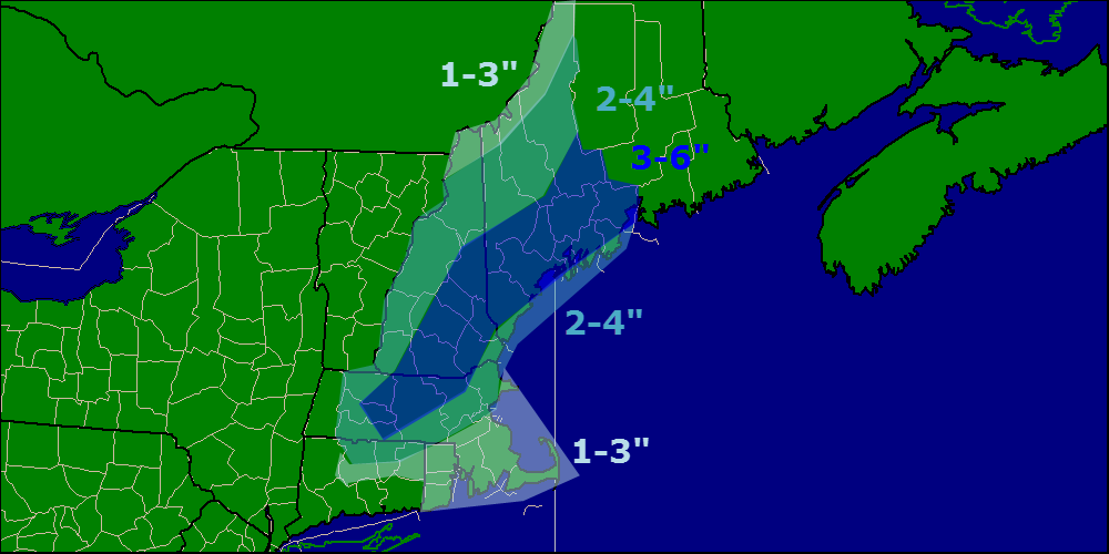
As for amounts, expect a wide swath of 4-8″ across Southern Maine and New Hampshire while coastal New Hampshire and Massachusetts will have to deal with a mix/rain line holding down accumulations.
Snow map.
More snow arrives tomorrow mixing with sleet/freezing rain along the coast. A warm up is expected late week with rain plaguing the area Friday. Do not fear fellow winter lovers! The cold returns Sunday and lasts as far as the eye can see.
What a change over the past few days! First we were looking at the potential for a foot of snow from a powerful ocean storm and now we are looking at 6″ from its wicked inverted trough. Remember that inverted or norlun trough from earlier this winter? They are impossible to predict where they will set up until they actually do set up. Now I am thinking it will set up right near Portland or maybe a little south. Either way, there should be snow breaking our today from “ocean effect” or lake effect snow but over the ocean. Ocean effect snow tends not to be as heavy as lake effect and that is what we will see today.
There is a developing low off the Carolina coast that is moving ENE. This low will skirt too far offshore to have too much of an effect. its norlun or inverted trough however will. This troughs are notoriously impossible to predict as we saw earlier this year. Right now my thoughts are that it will dump a sufficient amount (6″) to many across southern Maine. My snow map is below.
Snow map.
Check out my other two sites for town by town forecasts for the snow. Those will be updated with the 18z runs tonight. They can be found at the right of my page.
-Jack
After a January thaw of sorts, the cold air will return; with vengeance. A cold front will sweep across the area today lowering temps to seasonable levels. Wednesday there is a possibility for some light snow in the south but nothing much. Thursday, an arctic cold front sweeps south bringing below average temps. A warm front moves north Saturday followed by a strong cold front sunday.
as for any snow chances, there could be snow squalls associated with any of the cold fronts most likely not todays. The PNA will move + which is bringing in cool air however models are split down the middle on the AO/NAO but it does not look like any major snow events are in the forecast.
-Jack
Warm air will continue to push northward today and will have everyone over to rain with the exception of the north and mountains where cold air and snow will hang on for the remainder of the day. Even in the mountains, a change to freezing rain is expected dropping around .15-.3″ of ice. The whole storm clears out late this evening leaving a goregoues weekend for all.