Updated snowfall graphic


Updated amounts. Enjoy the snow!!

-Jack


Snowfall graphic for Tuesday storm


Here it is. Amounts may need to be adjusted a little. Happy snow!!

-Jack

Travel graphic for your return trip

Here is the graphic for your return trip. This is in effect friday morning through saturday afternoon. Red areas are were to expect major slowdows due to weather. Yellow areas show where delays are possible. Green areas are all clear.

Note: local areas in the “green zone” could have minor slowdowns due to local weaather eg. fog; black ice.

Have a safe return trip!

I am watching a potential storm early next week. Stay tuned for any updates.

-Jack

Thanksgiving travel graphic

Happy turkey day everyone!!

-Jack

Weekly graphic

Fairly quiet this week as Thanksgiving travel goes smoothly nation wide. Other than the North Western states where a storm will continue to bring incliment weather well into the week.

-Jack

Weekly graphic, Watching Thanksgiving day storm

There is a good potential for a low pressure area to form off the SE US coast. Weather it goes out to sea or moves right near the coast has yet to be determined.

-Jack

Advisory #2 on new Nor’easter

The next storm the east coast will be facing will be a very bad storm for Sandy ravaged areas. This storm will likely bottom out at 990mb slightly weaker then estimates from this morning and a day ago. These estimates suggested pressures of near 980mb. Regardless of pressures, this will be a very bad storm for all ravaged by Sandy. Winds of 35-50mph will ravage areas hit hard by Sandy. Models are trending east with this storm which means that there will be cool air in place in Maine allowing for some snow possibly accumulating to a few inches in mountainous areas. areas closer to the coast may see up to 1″. Accumulations will be tricky to forecast here due to the fact that the ground is warm and it will be a while for the ground to cool off enough to allow for snow to accumulate. 1-2″ of rain will be common from northern NJ to Cape Cod and possibly Seacoast NH.

-Jack

Advisory 1 on new Nor’easter

Less than a week after signing off from historic Sandy, I am back on with a new storm and new situation. This WILL NOT be another Sandy! I can not stress this enough. This storm will likely bottom out at 985mb. This is a measure of barometric pressure. Sandy was 945mb. Sandy was a hurricane while this will be a typical nor’easter.

This storm will be affecting Florida on election day likely causing some voters to stay home but that is another issue. The storm will come up the coast Wednesday affecting the mid-Atlantic areas. The storm will bring winds of 40-50mph winds and a surge of 2-5′ rainfall totals of 2″ will be common. This will not be a major storm though its impacts will be more damaging due to the fact that Sandy weakened our defenses both physical (seawalls, dunes) and socially (our red cross and other agencies like FEMA are already very busy with Sandy damage and power crews still face more than 1 million outages). This will just add insult to injury after a historic Sandy. Thursday the storm will stall off of the Jersey coast and slowly weaken as it moves to the NE thursday night.

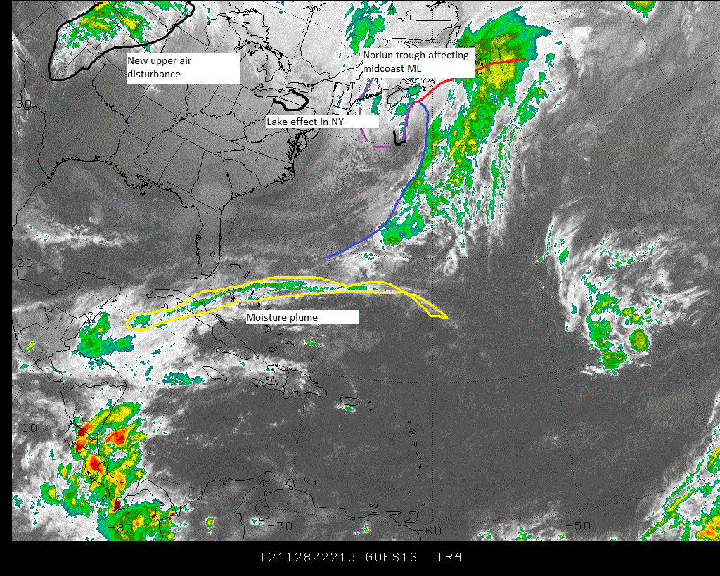
Snowfall is the tricky part to the forecast. There will be accumulating snow in the Catskills and the Whites with amounts possibly reaching a foot in the favored upslope regions. NJ, DE, and Eastern PA will see wet flakes though amours will be minor and uncirten

-Jack

Watching the models closely…

This is a special post to tell everyone that many of the models seem to like the idea of a powerful nor’easter heading up the coast next week.

Stay Tuned for updates!

-Jack