Hello everyone!
Another very quiet weather day is on tap today with clear skies, light winds, and moderate temps. Full details can be found in my WMW update.
-Jack

Hello everyone!
Another very quiet weather day is on tap today with clear skies, light winds, and moderate temps. Full details can be found in my WMW update.
-Jack
Hello everyone!
Today will feature quiet weather all around as cold high pressure crests over the region. Full details can be found in my Western Maine Weather update.
-Jack
Hello everyone!
Today will be a pretty quiet one by mid-January standards as CAA continues to bring in colder air from our neighbors to the north. As a result, highs in the 20’s are expected region wide with a weak trough bringing the chance for a few flurries to Maine and New Hampshire. No accumulations are expected and flurries will be scattered though almost everyone should see a few flakes.
-Jack
Hello everyone!
Today will be an interesting one region wide as our storm moves in. Expect light wintery precip across Maine and New Hampshire this morning with some light accumulations possible. Heavier precip moves in tonight, mainly in the form of rain, before wrapping up Monday morning as snow for some mountain areas.
This Morning
South of Route 2 and away from the immediate coast, the dominant precip type this morning will be freezing drizzle. A trace of ice is likely and a freezing rain advisory has been issued. Thankfully for the major ski areas in Maine (Sunday River, Saddleback, and Sugarloaf), this morning’s precip will be mostly in the form of snow with up to 2″ possible. A strong coastal front will keep the coast out of the woods for the freezing rain threat as temps will rapidly warm there once the front moves inland slightly.
As for Southern New England, far western MA and CT could see some freezing drizzle that could accumulate to a trace or so and areas away from the coast could see road temps lag enough for some slick spots this morning. Bottom line: travel will not be treacherous but could be slick in spots this morning. The freezing drizzle/snow does not arrive in Maine until after 9AM or so while SNE starts the fun a little earlier.
This afternoon
Light and somewhat scattered precip this morning will give way to steadier precip by this afternoon. Again, location will be the key for precip type as the coastal front begins to collapse westward. By around 4 this afternoon, the rain line should be near Paris extending back toward Lewiston and will be rapidly moving NW. Freezing drizzle and snow will continue in the mountains through the afternoon. Heavier precip will begin across southern New England and move NE this afternoon reaching Maine between 4 and 9PM depending on location.
This evening
Heavy rain for almost everyone tonight with the exception of far NW NH. SE winds will become very strong at the coast and could gust over 40 mph at times this evening. Since the low will track basically right over the NH/ME line, NW NH will remain on the cold side of the storm so all snow and sleet is expected there. A general .75-1.5″ of rain is likely with some of the hillier foothills possibly seeing 2″. 3-6″ of snow and sleet is likely for the parts of NH that stay all snow/sleet with 1-3″ for the rest of the ME mountains. With warm air flooding in at the surface, the higher peaks will stand the best chance for seeing snow.
Tomorrow morning
As the low moves NE and strengthens, the cold air will again collapse, this time to the SE and will race the dry slot to change the foothills back to snow before the precip ends. In the mountains, especially the western mountains, the cold air will have no problem beating the dry air and an additional 1-3″ is likely for the ME mountains. Keep in mind, over an inch of rain will have fallen since the last 1-3″ this morning so 6″+ is unlikely for most Maine areas. The summits of Sugarloaf and Saddleback could be the exceptions as their elevation will put them above several warm layers today.
All precip will come to an end by tomorrow afternoon as strong west winds bring in dry air. Westerly winds will be very strong both Monday and Tuesday gusting at times over 40mph due to intense cold air advection. As a result of the cold air advection, falling temps can be expected Monday with highs occurring in the morning hours. Temps will already be cold Tuesday and will rebound some but will still be falling most of the day.
-Jack
Hello everyone!
Special update this evening with the latest on our messy storm system moving into the region tomorrow. The storm track will be to our west meaning we are on the warm side of the storm so there will be a lot of rain. SE winds will be an issue as heavy precip could bring down strong winds just over our heads. Precip will start tomorrow morning and end Monday morning with the heaviest precip falling tomorrow night.
Snow
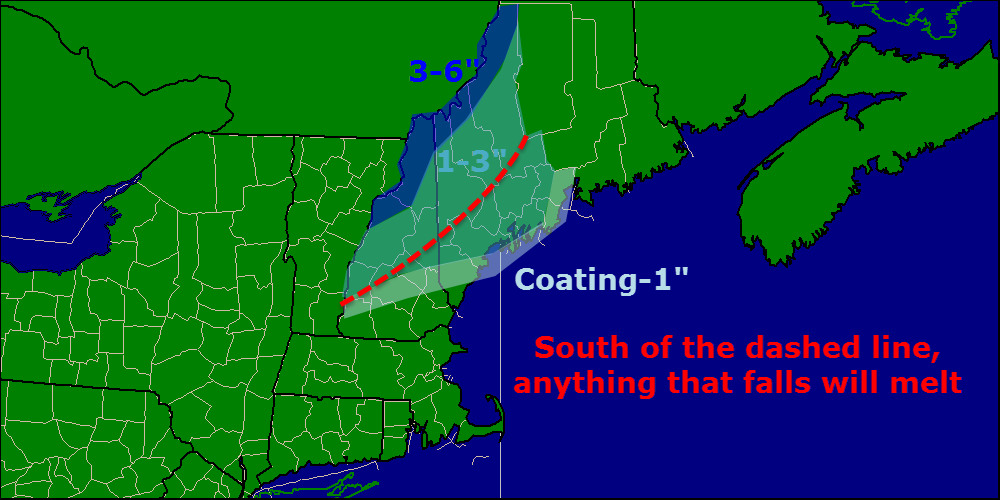
There will be two shots of snow with this storm, one at the beginning and one at the end. Very light snow at the beginning could drop a coating-2″ for most places. South of the red dashed line on the map, that’s all the snow that will fall and it will melt pretty quickly with the rain.

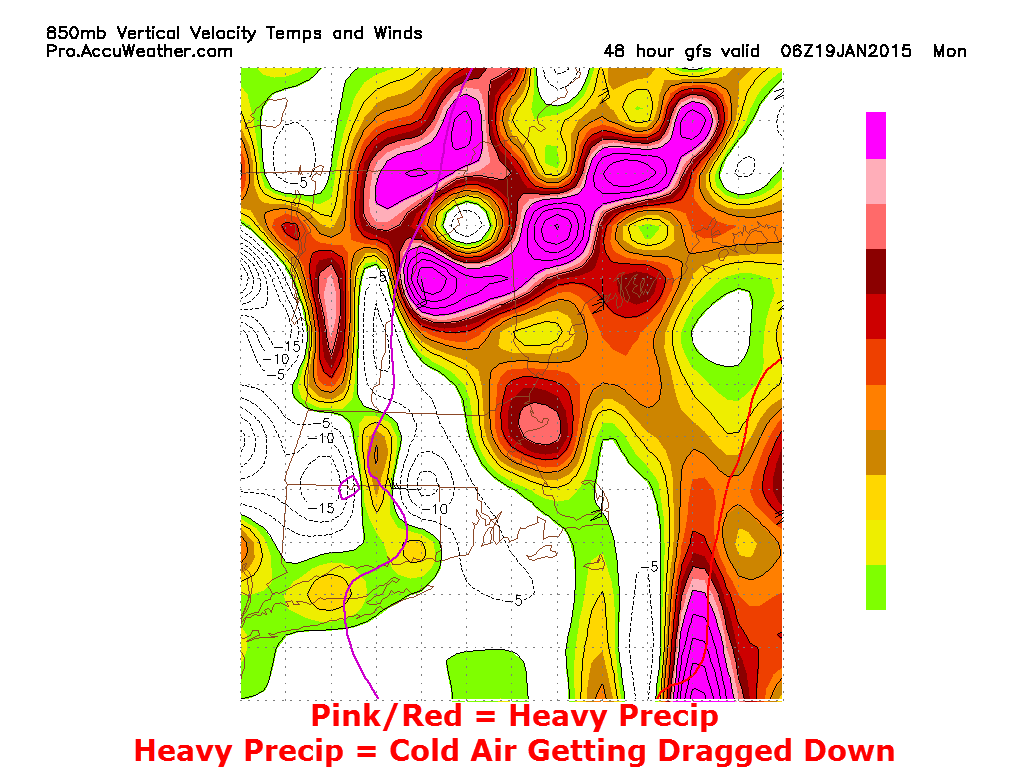
On the backside of the storm, intense upward motion, as seen here on the GFS’s vertical velocity map, will cause cold air aloft to be dragged down to the surface through dynamic cooling. All those big fancy words to say that the mountains are likely to see a quick shot of snow Monday morning that could drop an inch or two of snow. All in all, this won’t be a big snow producer but there will definitely be some flakes flying.
Wind

Winds will be another important factor to consider tomorrow night because they will be extremely strong only a few thousand feet up and any heavy bands of precip (there will be a few around) have the potential to bring down those winds. The map above shows the max winds in the lowest 1.5km of the atmosphere and not all of those winds will be mixed down. That being said, things are likely to get gusty along the coast and isolated 35mph wind gusts are possible. Winds die down and shift westerly Monday afternoon.
Rain
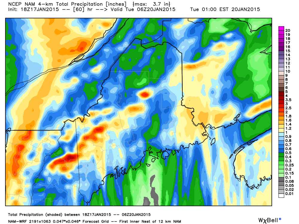
A general 3/4″ to 1.5″ of rain is expected for areas south of the mountains. The map above shows the total liquid as the NAM sees it which includes snow too. The higher rainfall amounts are likely to be found in the foothills where upsloping begins to take effect. Rain could be heavy at times but flooding concerns are minor as this will be a quick-hitting system and the snowpack should absorb most of the water.
Storm Timeline
Tomorrow Morning
 Warm Air Advection will start late tonight and SW winds will begin to bring in some low level moisture. SE winds at the surface will bring in warmer air and cause the coast to change to rain fairly quickly. The airmass ahead of the storm will be enough to keep inland areas snow to start.
Tomorrow Afternoon

SE winds both at the surface and aloft will cause the rain/snow line to collapse inland rapidly tomorrow afternoon. Heavy rain is beginning to organize over SNE as the low passes overhead. The mountains will hang on to the snow the longest, but even there, rain will creep in late in the evening.
Tomorrow Night

The peak of the storm will arrive tomorrow night as the low moves overhead. Rain will be tapering off over SNE as the storm moves north and the core of the rain moves to Maine. As the storm intensifies, dynamic cooling will cause the snow line to begin to collapse eastward beginning around 2-3AM. The cold will race the precip as the dry slot works in, beating the end of the precip in the mountains especially in NH. The cold arrives a little late for the foothills and the coast.
Monday Morning

Precip will be racing NE Monday morning as the snow line moves SE. NW of Bethel stands the best chance for some accumulation with the back end snows. Winds will calm down and shift to the west as precip moves out Monday afternoon.
-Jack
Hello everyone!
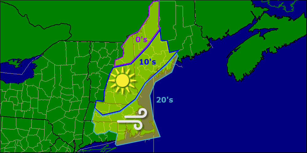
Not much weather to talk about today – it will be clear and bitter cold as high pressure builds in from the west. Highs will be generally in the 10’s with some 20’s at the coast.
Our more interesting weather arrives tomorrow evening as low pressure moves in from the west. THe low will redevelop offshore but instead of moving NE and bringing us a snowstorm, it will move due north right through Western Maine this bringing warm and wet conditions… for most.

Here is where I expect the low pressure system to track. Since the winds around a low pressure system spin counter-clockwise, warm air will have no problem spilling into the area Sunday afternoon. Everyone but the far northern mountains and the White mountains will see rain Sunday afternoon/evening.
As the low strengthens and moves north/northeast early Monday morning, cold air aloft will make its way to the surface through a process known in technical terms as dynamic cooling. Basically, this is when cold air aloft gets dragged down to the surface via heavy precip. One very good way to pinpoint where this will happen is to look at upward motion in the atmosphere.
Even though most areas see some rain Sunday evening, it will flip to snow from west to east Sunday night and will become very heavy which means even though surface temps will be marginal (30-35), the mountains should have no problem accumulating if/when they change to snow. Farther south, the rain will be heavy but the cold air aloft will be lacking so most places south of route 2 will miss out on the snow. The exception to that will be the Whites who will stay mostly snow the whole way through as they stick up above the warm layer.
I’ll have another update with the latest data this evening.
-Jack
Hello everyone!
Today will feature the passage of a strong arctic front which will provide a trigger for snow showers and squalls which will move through this morning. Highs for the day are occuring right about now and temps will be falling throughout the day as gusty NW winds bring in colder air. Winds could gust over 40mph and thus wind chils will be a problem as temps get lower. Wind chill warnings are up for the mountains. Our next chance for a storm arrives Sunday night into Monday.
-Jack
Hello everyone!
Today will be cool but not cold with some flurries along the coast. Full details on that as well as a peek at the timeframe for our next storm threat in my Western Maine Weather update.
-Jack
Hello everyone!
Today will be a cold one across the region as Arctic high pressure settles in. Find full details on today’s forecast as well as a look at a micro thaw this weekend in my update over at WMW.
-Jack
Hello everyone!
Today’s forecast can be summed up in one word: cold. With Canadian high pressure in place, expect a mostly sunny day with highs in the single digits above or below 0 in the mountains and in the 10’s at the coast. Brisk northerly winds will make it feel even colder today with widespread subzero wind chills.
-Jack
