More Messy Weather Tomorrow Into Friday

Hello everyone!

Early spring is in full swing in Maine and this week will be a good reminder that Spring is a battle between warm and cold. In the beginning, cold wins. Slowly but steadily, the warm air wins out but it will take many messy battles before that happens. For now, the advantage is with the cold. We’ll see that in full swing in the next few days as a powerful Colorado low which is currently bringing every type of weather under the sun from Colorado/Nebraska blizzards to Texas tornadoes. The storm will be significantly weaker by the time it gets to us but will still be potent enough to cause some issues tomorrow into Friday.

The Setup: This Evening

Afternoon Observations Showing Our Next Storm Setting Up To Our West. Image Credit: COD

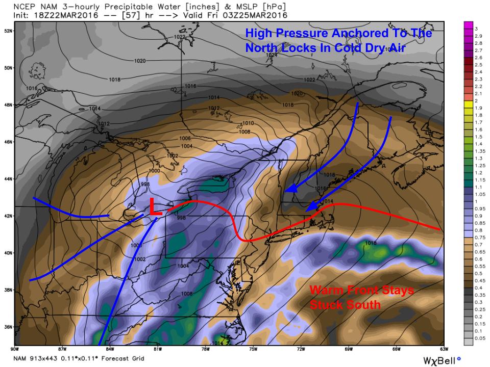
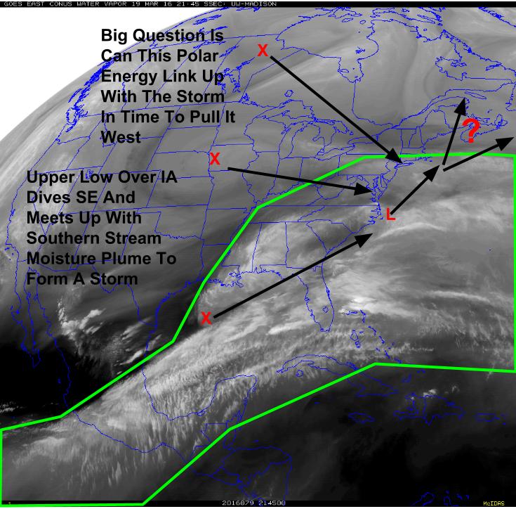
A cold front is moving through the area currently (blue line on map) and winds behind it are out of the north which is bringing in cold air. Canadian high pressure is diving SE across Eastern Canada and will continue to supply this cold air through most of the event. Low pressure is moving across the Western plains and will be moving NE towards our area tonight into tomorrow. A warm front extends out ahead of this storm and is linked to the cold front bringing us the cold air this evening. This warm front will try to push north tomorrow and Friday but cold, dry air in place will impede its progress significantly.

Round One: Snow Tonight Into Tomorrow Morning

HRRR Showing Snow Moving In Tomorrow Morning Well Ahead Of The Main Storm. Credit: Weatherbell

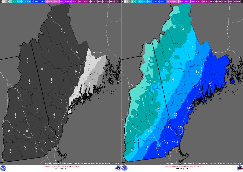
Precip starts late tonight and tomorrow morning in the form of snowfall. Initially, everyone is snow and very light accumulations are likely for everyone by the morning commute. Snow will be light though and major issues are not expected. That tapers off tomorrow morning leaving mid-day tomorrow mainly dry but cool. The main system can be seen at the very end of the loop spreading into western PA/NY.

Round Two: Main Storm: Surface Edition Friday

12Z HRDPS Showing Winds Friday Morning At The Surface. Notice The Warm Winds At The Coast And The Cold High Pressure (No Winds) Holding Strong Inland. Image Credit: Weatherbell

The warm front mentioned in the setup section will attempt to move north overnight tomorrow into Friday. It will hit a brick wall at around route 1 which will let temps rise above freezing at the immediate coastline but will keep inland areas below freezing. This pattern should continue through mid afternoon Friday before the low passes overhead and the trailing cold front busts up the inversions holding the low level cold in place. This is the surface pattern that is known far and wide for not changing. Guidance says most of the region goes over to rain by 9 AM. I think it will be 3 or 4 in the afternoon before temps rise above freezing in inland/mountain areas.

Round Two: Main Storm: Upper Air Edition Friday

12Z NAM Showing The Upper Air Setup Friday Morning Over Lewiston.

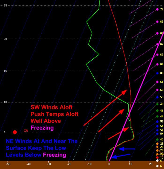
Aloft, a much different story will play out. There is no Canadian high above 3-4 thousand feet. Therefore, there is no source of cold air. Warm air blasting north will have no trouble pushing the cold air in place out of the way. This will result in a classic mixed precip setup where snow forms in the cold layer really high up before melting in the warm mid levels of the atmosphere. It then refreezes close to the surface resulting in sleet and freezing rain depending on the depth of the cold at the surface. With the cold Canadian high just to our north, there will be a continuous feed of cold dry air being funneled down the east side of the mountains. This is a classic Cold Air Damming setup and CAD always lasts longer than you think even if you think it will last longer than you think. That tongue twister boils down to the fact that cold air moves when it’s good and ready too and it’s not usually to motivated to go anywhere.

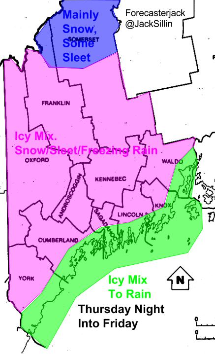
Round Two: Main Storm: Impact Map Friday

Expected Impacts From This Storm

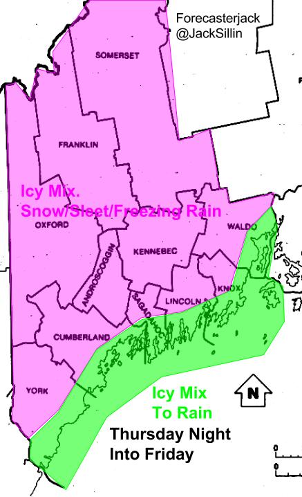
Following the initial snow tomorrow morning, this is what I expect for impacts. Everyone starts out with a little mix but strong SE winds should quickly warm the coast up above freezing resulting in mainly rain there. Despite that, do be prepared for slick conditions everywhere as sleet and freezing rain are a dangerous combo especially with some leftover snow around. Inland, even a few miles, cold air will put up a much mightier fight. Look for snow changing to sleet changing to freezing rain. Sleet and freezing rain look to be the dominant precip types through this event. Snow will quickly change over to a mix as warm air blasts in unimpeded aloft but for most areas away from the coast, the surface high will be enough to keep temps below freezing at the surface for a good long time. In terms of accumulation, in the green area, a trace to a tenth of an inch of ice is expected. In the pink area, a tenth to a quarter inch of ice is expected.

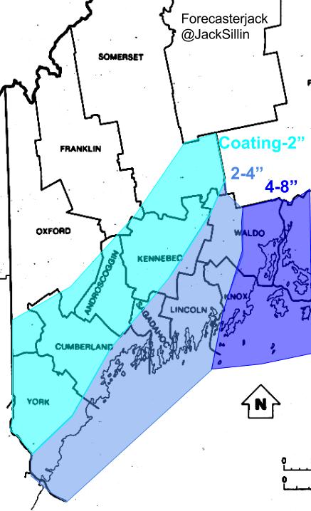
Rounds One And Two Combined Snowfall: Tonight Through Friday

Expected Snowfall Before The Change To Mix/Rain

Here is what I expect for snowfall before we change to a mix or rain depending on location. While I have the Penobscot Bay and York County regions missing out on any accumulations, I wouldn’t be overly surprised to see coatings there tomorrow morning. This all basically is gone Friday afternoon as sleet and freezing rain turn the ground into an icy crust. The March sun angle is still a factor here despite cloudy conditions and sleet/freezing rain could have a hard time accumulating on pavement. However, please use caution especially Friday as any untreated roads will likely be slick. This snowfall map includes precip tonight and into tomorrow morning.

Round Three: Possible Storm: Early Next Week

12Z GEFS Ensembles Showing The Potential For More Stormy Weather Early Next Week. Image Credit: Weatherbell

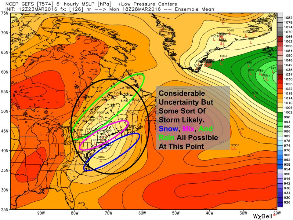
Following this storm, we have a nice early Spring weekend to look forward too with cool temps and sunny skies. However, tranquil patterns rarely last long in March in Maine and by early next week, another storm threatens. As you can see here, guidance is converging on the idea we see some sort of precip. How much/what type is still yet to be determined. Snow, mixed precip, and rain are all on the table as well as no storm at all though that is becoming less likely. While it is too early to offer details, I just wanted to put that out there as something to watch in the coming days.

-Jack


Cloudy But Mainly Calm Today

Hello everyone!

A cold front is sinking south across the region currently as high pressure builds in from the north. Look for mainly cloudy skies with the chance for a shower or two as this front moves south. Temps will rise into the low to mid 30’s north and the upper 30’s to low 40’s south.

-Jack

Winter’s Last Stand: Episode Two Late This Week

Hello everyone!

Like a bad reality TV show, winter’s last stand looks to have several unwanted episodes as we head into early April. Having already seen our first event out of this newly active pattern, our attention now turns to the next two threats for winter weather which are on the horizon in the coming week.

5 PM 850 MB Observations Showing Tonight's Round Of Precip Approaching. Image Credit:  SPC Mesoanalysis
5 PM 850 MB Observations Showing Tonight’s Round Of Precip Approaching. Image Credit: SPC Mesoanalysis

Our first shot at winter weather arrives tonight in the form of a weak burst of warm air aloft which will set off some light snow in the mountains. This activity will also be associated with the push south of cold air at the surface in the form of a backdoor cold front. The combo of surface cold front and mid level warm front will lead to light snow in the overnight hours across the north country. Mainly snow is expected with light accumulations.

Expected Snowfall Tonight Into Tomorrow Morning

This light snow will provide the first ingredient for late week trouble: cold air. A sprawling Canadian high pressure system will build south behind this backdoor cold front delivering more cold air. This won’t be Arctic air but it will be cold enough to make precip that falls when low pressure approaches from the west fall in the form of snow/sleet/freezing rain for many as opposed to rain. Guidance is still struggling to figure out how long the cold will last but seeing as this is looking like a nearly classic Cold Air Damming (CAD) situation, I think it best to go with the old rule of thumb: CAD will always last longer than you think, even if you think it will last longer than you think. The long and the short of it is, cold air in Maine leaves when it’s good and ready, not when warm air tells it to and it’s about as motivated as a teenage boy.

18Z NAM Showing The Setup For Friday's Winter Weather. Image Credit: Weatherbell
18Z NAM Showing The Setup For Friday’s Winter Weather. Image Credit: Weatherbell

Here’s the setup late Thursday evening as low pressure approaches from the west. Cold, dry air will be in place shown by isobars bending over our area and shades of Grey appearing in the Precipitable Water (PWAT) fields. The scale on the right shows how grey colors represent low PWATs and thus dry air. The image also shows sea level pressure which shows high pressure anchored to our NE feeding cold air south. The wavy nature of the warm front also signals the lack of a concentrated push north of warm air as well as the potential for redevelopment of low pressure offshore. The secondary coastal storm is something that guidance is hinting at and with the strong high pressure trying to ‘split’ the storm in two, this seems like a reasonable possibility. This is unlikely to lead to a strong coastal storm and precip is likely to remain light to moderate through the duration but it would help to keep that cold air locked in across the area.

Expected Impacts For Thursday Evening Into Friday

In terms of impacts, this one will be a mix of snow, sleet, and freezing rain for most of the area with the far north possibly holding on to mostly snow and the coast seeing a change to rain at some point. Everyone will see slick travel Friday during the morning commute and roads are likely to remain slick for the evening commute away from the coast. While it is still a little early to call exact amounts, I expect a widespread 1-3″ of snow with coatings along the coast and 4 or 5″ possible in northern Franklin and Somerset counties. In terms of ice accretion, light to moderate amounts are likely and in some areas, especially inland, it could be enough to threaten power lines. This does not however look to be a major ice event. With the storm weakening and possibly splitting, there does not look to be enough precip to cause major issues.

I’ll have more info in the coming days on the Friday event.

Another round of wintry weather is possible early next week. While it is still a week away, there are reasonably strong signals we see some sort of precip. As always this far out, any and all solutions are on the table from snowstorm to rain storm to sunny day. More on that as we get closer.

-Jack

A Quiet Lovely Day Today

Hello everyone!

A rather nice Spring day is on the way this morning as temps currently below freezing rise into the low to mid 30’s north and mid to upper 40’s south. West/North West winds will be busy today with gusts over 20 mph possible. This will lead to the classic upslope/downslope pattern where the mountains see clouds and flurries while the coast enjoys warm, sunny conditions. Skies will be mainly sunny but clouds will be on the increase this evening ahead of our next storm.

More details on that this evening

-Jack

Episode Two Of Winter’s Last Stand Thursday Into Friday

Hello everyone!

Our storm from this morning is now racing NE and most of the area is seeing sunny skies . Coastal areas saw 4-8″ while inland areas saw 2-4″. The forecast worked out great for the Midcoast but busted fairly badly west of Brunswick. The culprit was a westward shift in mid level (5,00-10,000 feet up) storm systems. I’ll try to get a full post out at some point explaining that.

12Z GEM Showing The Setup For A Storm Late Week. Image Credit: Weatherbell

In the meantime, we have more winter to look forward to! Following nice weather tomorrow, a weak clipper will drive a backdoor cold front through the region Wednesday. Behind it, cold Canadian high pressure will settle in for Thursday which sets up episode 2 of winter’s last stand. A low pressure system will move along or a little north of this front drawing warm air north as it goes. We’ve seen this a million times before, when warm air crashes into cold air, trouble ensues and this time is no different. Precip likely breaks out Thursday afternoon/evening and lasts through Friday midday.

12Z CMC Showing A Setup Ripe For Mixed Precip Overnight Thursday Into Friday. Image Credit: Weatherbell
12Z GEM Showing A Setup Ripe For Mixed Precip Overnight Thursday Into Friday. Image Credit: Weatherbell

Cold high pressure to the north will play a big part in this forecast. One of the things you learn in forecasting, especially forecasting in Maine, is never to bet against Canadian high pressure. Cold air at the surface always lasts longer than you think, even if you think it will last longer than you think. Guidance is still split on exactly how this storm pans out. It is still 3-4 days away as well which means that there is more than enough time for the forecast to change. However, looking at the overall pattern, the solution the 12Z GEM (shown in maps given here) portrays is one I could absolutely see happening.

While the details of how much precip/precip type/exact timing/etc are still to be worked out, it looks like we’re in for another shot of wintry weather to close out the week. The greatest threat for this one is in the mountains and ski areas could very well see some snow out of this one in addition to any mixed precip warm air aloft could cause.

More on this in the coming days as the details come into focus.

-Jack

Episode One Of Winter’s Last Stand Today

Hello everyone!

Today will feature snowy conditions for many as a coastal storm moves to our east. Snow is already falling this morning and will continue to do so through the early afternoon before tapering off. My snowfall forecast from last evening still looks good for most though short range guidance and radar trends are suggesting areas just inland could do a little better than thought due to the nature of the banding structure this morning. Temps will begin in the 20’s but will quickly rise into the low to mid 30’s which will melt some of the new snow. Roads will be slick for this morning’s commute and many schools have delayed or closed. Local media has the comprehensive lists on who is delayed/closed so check with them or your local school district for that information.

HRRR Giving An Idea On How Precip Evolves Today. Credit: Weatherbell

Episode two of winter’s last stand is later this week as a front stalls near or over us which could bring snow/sleet/freezing rain/rain depending on where it sets up. More on that in the coming days.

-Jack

Winter’s Last Stand Begins Tonight

Hello everyone!

Our very tricky forecast remains a nail biter as the storm begins to develop off the Carolina coast. A large plume of moisture extends from the Eastern Pacific to the Western Atlantic and two disturbances are dropping in from the NW helping to form the storm. After careful analysis of Water Vapor satellite and observations as well as forecast model guidance, it seems that the more potent disturbance will likely arrive just in the nick of time for the Midcoast but a hair too late for everyone else.

A Comparison Of Observed Reality To Model Forecasts For The Same Time (5 PM This Evening). Image Credit: Accuweather and SPC

This is the comparison I’m talking about with regards to the energy blasting through the Great Lakes. Notice the disturbance (marked here by the 534 dm contour line). It is a little farther behind the NAM forecast. These images are valid at the same time (5PM this evening). This is the critical energy that, when it gets here, will tilt the upper level trough negative which will intensify the storm and bring it west. This happens just a little too late for us. Model guidance has backed off on snowfall amounts today, probably as they are sniffing this out. Given that even the most up to date guidance (18Z NAM used here) is too fast with this energy, I’ve opted to go even lower with my snow totals. Without the trough tilting negative, moisture cannot be wrapped west and precip won’t get much past the coast.

HRRR Showing Precip Arriving This Evening. Credit: Weatherbell

In terms of how this all goes down, snow will move in late tonight and be light to moderate through midday tomorrow before tapering off. Really this one only impacts the coast with the mountains and NW foothills seeing but a few flakes. Take a look at the simulated radar above. Those not in the blue (snow) during this loop likely escape with a few flakes, if any at all. The Midcoast could see some heavy snow bands as the storm passes by.

Expected Snowfall Totals

In terms of accumulation, this is what I’m thinking as of now. The Midcoast will see the most as it could get into the heavy bands and will be closer to the center of the storm. A sharp cutoff will occur somewhere near Brunswick but it will be impossible to pinpoint that until the snow is actually falling. West of that cutoff, an inch or so is expected while east of that cutoff several inches are likely. Areas near Camden/Rockland/Belfast are pretty likely to see more than 4″ and up to 6 or 7″ is possible should the banding set up right. Farther north and west, little is expected and the mountains could escape without a flake.

NWS Best/Worse Case Scenarios From This Morning.

To give you a sense of how this storm has puzzled even the pros (not just me!), here was what the NWS in Gray thought we could see in the ‘best case scenario’ and ‘worse case scenario’ this morning. This is absolutely not intended to criticize their forecast, this is to show you how uncertain this forecast is. It’s always a good idea to be prepared for the worst case scenario even if it only happens one in every ten times.

All snow wraps up from west to east early tomorrow afternoon with temps rising into the low to mid 30’s and northerly winds strengthening.

This sets up part two of winter’s last stand which will feature snow, sleet, freezing rain, and cold rain to end the week. More details on that tomorrow.

-Jack

The Calm Before The Maybe Storm

Hello everyone!

Today will feature increasing clouds, cool temps, light northerly winds, and lots of confusion for meteorologists as our next storm approaches. The first ingredient for snow is cold air and that’s the ingredient we got Friday. It will make its presence felt today as highs struggle into the mid to upper 20’s north and low to mid 30’s south. Snow should hold off until late tonight but clouds will be spreading north throughout the day.

In terms of our storm, nothing big has changed from last night’s thoughts. Guidance has unanimously indicated overnight that more snow may be in store but it’s hard to say at the moment if that’s fully true. As I mentioned in last night’s update, the forecast hinges on how quickly energy diving SE across Canada (currently approaching Lake Superior) can get here to pull the storm west. 500mb analysis also paints a similar picture. Based on that, there is reason to think that guidance pointing to a little more snow may indeed be correct. 6″ of snow is not out of the question along all immediate coastal areas and a Winter Storm Watch is up for the immediate coast due to the threat for 6″ or more of snow. The Midcoast still looks to take home the biggest trophy with 8″ of snow possible there. I’ll have a full update this evening.

-Jack

A Glancing Blow Sunday Night Into Monday

Hello everyone!

Boy has this been a fun one to forecast. As one of your sources for weather information (you should always consult the NWS and local media too!), the last thing I want to do is lead you on a roller coaster ride in terms of the forecast. To flip flop the forecast each day heading into a storm is something I hate doing. I want to give you a good idea of what to expect a few days out and then fine tune the details as we approach the event. With that said, this storm has led me on a wild goose chase in that every day, everything I look to points to something different. This isn’t just the whims of the model guidance I use to make forecasts, this is observations and satellite imagery painting completely different pictures. There are many moving pieces and it’s hard to figure out where they’re all going to go and what they’re all going to do. If life was full of easy forecasts, I wouldn’t be doing this. With all that out of the way, let’s try to figure out the forecast.

Evening Water Vapor Satellite Showing Many Moving Pieces (Including Lots Not Annotated!). Image Credit: SSEC

Water Vapor satellite imagery this evening shows all the parts of our storm. I’ve marked the disturbances and where the surface low will form and where it could possibly track (approximately). The ULL over Iowa is diving SE and will merge with a weak disturbance embedded in a deep plume of subtropical moisture which is marked in Green. Their interaction is beginning to form a storm over the SE US. When they merge, the storm will intensify a little bit as it begins to move NE. The real question has to do with Polar energy dropping down from the Western side of Hudson Bay. It has until Sunday night to get all the way to NY (about 1500 miles). It’s a race against time. If that energy crosses the finish line in time, it intensifies the storm, helps tilt the upper trough negative, and in turn wraps heavy precip back into our area. If it doesn’t, the storm continues at a moderately weak intensity ENE out to sea leaving us with but an inch or two.

BUFKIT Profile For Portland Showing Approximate Start/End Times As Well As The Mechanics Of Snow Growth.

It is becoming more and more clear that this storm isn’t going to drop a lot of liquid. However, given cold temps and a reasonably solid snow growth setup (see right), the snow could fluff up enough to lead to a couple of inches despite a lack of liquid. I don’t think this will be pure powder snow, but I also don’t see it being cement. Look as much or as little as you like at the image above, it shows/explains a little what you need for snow to form and what we have. Much like a Venn diagram, where they all intersect is where the snowflakes are forming. Based on this info, expect snow to start tomorrow evening. I suspect this may be a little late as the mid level dry air isn’t too stubborn compared to some other events. Snow looks to be light to moderate through the event before ending midday Monday. The ‘heaviest’ of the snow will be during the Monday AM commute though I don’t see it being all that heavy.

My Snowfall Forecast

Here are my thoughts on snowfall. Earlier today, I was ready to pull the trigger on lower snowfall amounts but afternoon guidance and a couple of things I noticed on the WV satellite and in the observations this afternoon have led me to remain more or less unchanged with my snow map from yesterday. I cut back a little on the back edge of the precip as all indications are that this will feature a sharp cutoff. I bumped up snowfall a little along the midcoast where the heaviest snow looks to fall. While 8″ seems like a stretch, 5 and 6″ amounts seem very reasonable along the Midcoast. Unfortunately for ski areas looking to refresh the base, this one looks a little too far east. Thankfully for skiers, both Sugarloaf and Sunday River have fired up the snow guns again! With cold temps lasting through midweek next week, snowmaking will remain possible for a solid few days.

A warm up is in store headed towards the end of next week and some wild temperature swings are looking likely heading into April.

I’ll have another storm forecast tomorrow evening.

-Jack


Much Cooler Today

Hello everyone!

Today will feature mainly sunny skies, cool temps, and decreasing winds. NW winds behind a cold front have brought in much cooler air and we will be feeling that throughout the weekend. NW winds are still blowing this morning but will be settling down as time goes on. Look for highs in the 20’s north and 30’s south.

The Sunday/Monday storm looks to head mainly out to sea. I’ll have an update on that this evening.

-Jack