A Warm And Dry Week Ahead

Hello everyone!

We’re back to our regularly scheduled programming this week as far as the weather is concerned. Cool and dry conditions today will give way to warm and slightly humid conditions by Friday before a cold front brings some drier air in for a warm and dry weekend next weekend. The only chance for precip will be some showers on Friday.

3:30 PM Observations Verifying Today's Forecast
3:30 PM Observations Verifying Today’s Forecast

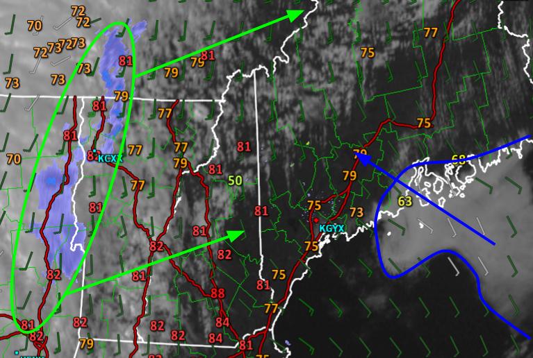
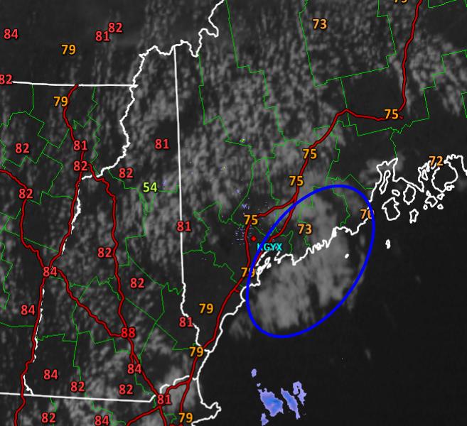
Today’s forecast worked out quite well. Morning rain moved out right on time and by 8:30 or so even the easternmost reaches of the midcoast were dry. Clearing quickly followed, as forecast, and temps rose into the 60’s and 70’s, also as forecast. The upslope/downslope pattern I talked about this morning is clearly visible on the satellite imagery this afternoon with clouds over the mountains and sun along the coast. The one mistake on the forecast was to overestimate temps in Northern NH. Areas under the clouds barely made it to 60 and spent most of the day in the 50’s which was a bit cooler than I thought.

12Z 4km NAM Showing High Pressure And Light Winds For Tonight. Image Credit: Weatherbell

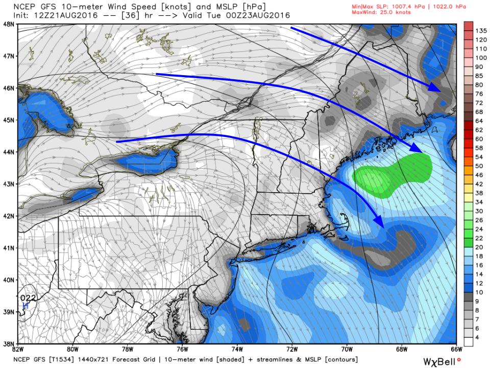
High pressure will slip just to our south (black circle) tonight as the cool winds of today prepare to give way to the warm breezes of tomorrow. In between, there won’t be any wind and as a result, temps will fall into the 40’s for most tonight with some 50’s across the south and east. Some of the most sheltered mountain valleys could see temps right around or even a little below 40. Radiational cooling does wonders! Warm and dry conditions are expected for tomorrow with highs generally in the 70’s.

12Z GFS Showing The Pattern For Late Week. Image Credit: Weatherbell

Temps will increase a couple of degrees each day from tomorrow through Friday and dew points will do the same. By the end of the week, we’ll have warm and sticky conditions but a far cry from the downright stifling weather of a couple weeks ago. Highs are expected to top out in the 80’s with dew points in the 60’s on Thursday and Friday before drier air works in for the weekend. That drier air will filter in behind a cold front that moves through on Friday bringing with it some scattered showers. No significant rainfall is expected in the next 7-10 days. After the front on Friday, warm and dry weather is expected to continue through next weekend and into early next week.

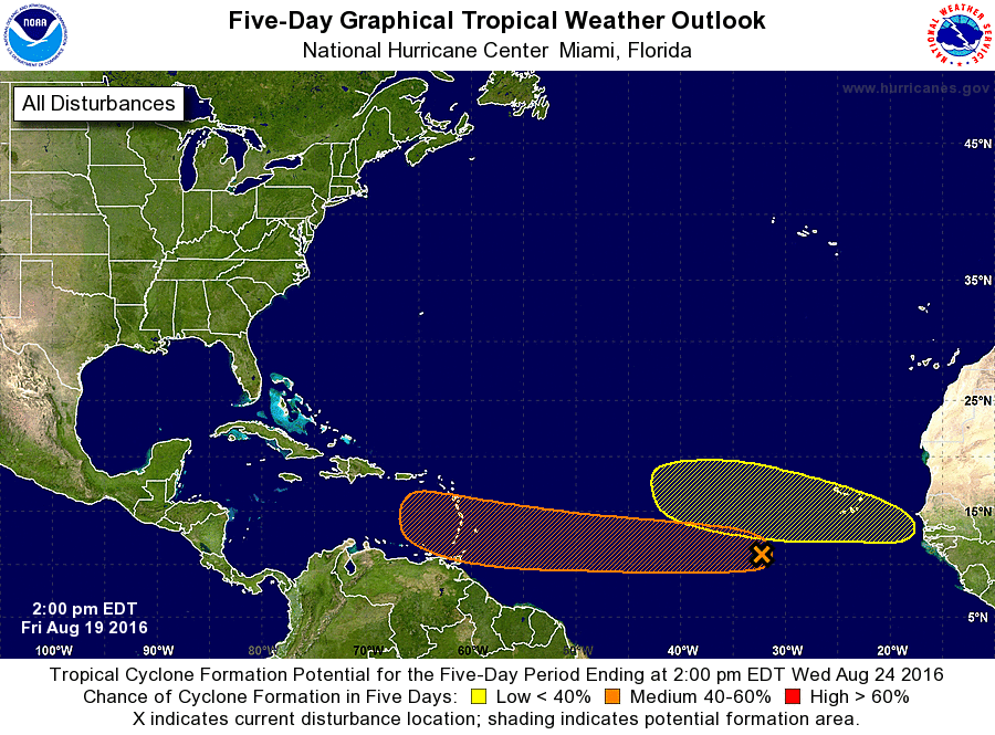
The tropics continue to heat up. To keep tabs on what’s happening down south, check out the new tropical weather page. It will be updated before 6:00 this evening with my latest forecast.

-Jack

Cooler, Drier, And Breezier Today

Hello everyone!

Showers are moving rapidly ENE this morning and as of 7 AM are only still going over the midcoast. By 9 AM or so, all should be dry. NW winds will set up the classic upslope/downslope pattern where the mountains see clouds and possibly a shower or two through the mid afternoon hours while the coast sees sunny skies. Temps will range from the mid to upper 60’s in the mountains and in eastern areas to the mid to upper 70’s over SW areas. NW winds will be gusty today with gusts 25-30 mph at times. Winds will settle down this evening setting up strong radiational cooling for tonight. By tomorrow morning, temps will be in the 40’s for most places with a few low 50’s along the coast. Fall is coming! Humidity will also be near rock bottom which will contribute to awesome feeling weather both today and tomorrow.

A look ahead at a very uneventful week in weather as well as another update on the tropics will come this evening.

-Jack

Showers Bring Heavy Rain Tonight Before Cooler And Drier Conditions Early Week

Hello everyone!

A cold front is incoming this evening and will cross the area tonight and early tomorrow morning. Showers will accompany this front with heavy rain and possibly a rumble or two in the far south. No severe weather is expected, just heavy rain. Rain will be heaviest in the north where up to an inch is expected. It will be lightest in the south where some areas may only pick up a quarter inch. Rain races NE Monday morning with clearing skies and gusty NW winds Monday during the day. Those NW winds will bring much cooler and much drier air in for Tuesday and Wednesday. An approaching front will bring SW winds and warmer air for late week with showers possible by the upcoming weekend. Just as a reminder, current information on tropical weather is now on the new tropical weather page.

4:00 PM Observations Verifying Today's Forecast
4:00 PM Observations Verifying Today’s Forecast

Today’s forecast worked out pretty well and the only glaring error was that there was more sunshine than expected. So far I haven’t received any complaints about that! Clouds are still slowly filtering in from the west while the Midcoast got their predicted marine fog. Temps look good with the only glaring error being lower temps (60’s) along the midcoast where the fog hasn’t let up. I have doubts about the 88 degree reading in Concord as no other station in that area is above the low 80’s but if that is actually accurate, that would be the other mistake as far as temps go. Overall, I’m pretty pleased with today’s forecast.

8 AM Upper Air Observations Showing The Overall Pattern. Image Credit: Meteocentre

A deep trough is located over the Great Lakes this evening with an associated surface low near the SE corner of Hudson Bay. Ahead of the trough, strong blocking ridging exists over the Canadian Maritimes. In between, SW flow is bringing warm moist air northward. Strong NW flow behind the trough and attendant front will bring cool, dry air sourced from Northern Canada before SW winds ahead of the digging trough in the Pacific NW bring warmer air for the upcoming weekend.

HRRR With An Idea Of What The Radar Might Look Like Early Tomorrow Morning. Image Credit: Weatherbell

In terms of what to expect tonight, showers are just now moving into far Western VT which means that western NH will start to see drops in 2-3 hours. It won’t be until well after dark that western Maine starts to see the rain move in. The rain will be associated with a single N/S band containing heavy rain and possibly a rumble or two in the far south. The band will be wider and heavier in northern areas resulting in higher totals there. The HRRR map above illustrates the setup well. The map is valid at 4:00 tomorrow morning. Rain will move out of Portland by 6 AM and out of the midcoast by 8. Clearing will follow.

12Z GFS Showing Gusty NW Winds Tomorrow. Image Credit: Weatherbell

Behind the front, gusty NW winds are forecast to develop. Winds could gust over 30mph at times as cooler and drier air works into the region. Look for these winds to quickly downslope the coast to sunny skies while upsloping may postpone sunshine for the mountains. Eventually, the air will become so dry that even with upsloping, the mountains will become sunny by afternoon. Dew points are forecast to drop to near 40 by tomorrow night. As winds settle down tomorrow night, temps will fall too. By Tuesday morning, the first fall like chills will be felt with temps bottoming out right around 40 in the north and 50 in the south with very dry air.

12Z GFS Showing Warm SW Winds Ahead Of An Approaching Front Late Next Week. Image Credit: Weatherbell
12Z GFS Showing Warm SW Winds Ahead Of An Approaching Front Late This Week. Image Credit: Weatherbell

Not ready for fall? Not to worry. By late in the week a front will be approaching from the NW and ahead of it SW winds will bring in slowly increasing warmth as well as humidity. While conditions won’t be stifling, the word sticky will once again come to mind by the upcoming weekend. As far as precip goes, the front won’t have a lot of dynamics associated with it and so scattered showers/storms are likely the most we’ll get from that front. After that, dry and warm conditions are likely to kick off next week.

Be sure to check out the new tropical weather page to keep tabs on the Atlantic disturbances 90L and 99L without the hype you may see on social media. The official NHC forecast, my forecast, and links to all the tropical weather information you need to take your own look at the tropics is all there. Check it out!

-Jack

Cool But Cloudier Today

Hello everyone!

Today will feature a mix of sun and clouds with the cloudy side of that battle eventually winning by evening. S/SE winds will slowly strengthen through the day to 15-20 mph by sunset. These winds will bring in cool, humid air off the water. With humid air from the south going over our cold Maine waters, fog will likely develop and move inland this afternoon and especially this evening. Elsewhere, morning sunny spots will give way to overcast skies by sunset as the front nears. Any showers though should wait until after 10 or 11 at night. They will move west to east and be heaviest in the north. More details on the rain tonight in this afternoon/evening’s post. Highs today will be cool with most areas between 70 and 80. Some low 80’s are possible in southern NH.

For the latest information on the tropics, please check out the new tropical weather page which features official NHC forecasts, my forecast, and links to find other helpful tropical weather information.

-Jack

Cold Front To Bring Heavy Rain, Cool Temps Sunday Night

Hello everyone!

Slightly more humid air is beginning to filter into the region today ahead of a cold front that will bring showers to the area Sunday night. Some of those showers could contain a rumble or two and may produce heavy rain especially north. Cool, dry air floods in for Monday and Tuesday before SW winds slowly increase both temps and humidity through next weekend. Our next chance for precip arrives next weekend with the passage of a weak front.

4:30 PM Observations Verifying Today's Forecast
4:30 PM Observations Verifying Today’s Forecast

Today’s forecast wasn’t super awesome. The biggest issue was cloud cover. A layer of marine stratus/fog developed over the waters from Portland NE through the midcoast. This stratus layer moved onshore over the midcoast bringing overcast conditions. This mistake was due to an underappreciation for dew points to the south that advected northward on SE winds that developed as high pressure slid offshore. Otherwise, most areas saw some sun as temps rose into the 70’s to low 80’s as expected. Overall, not a super great day but definitely not a disaster.

Current 4:30 PM WV Satellite Showing The Setup For Sunday Night. Image Credit: COD

Water vapor imagery shows the setup for the next few days perfectly. A plume of moisture extends from tropical storm Kay (not pictured) in the Eastern Pacific to a storm over Wisconsin. Cool, dry air is streaming south into the Northern plains. Along the boundary between the two, showers and storms are ongoing (storms are anomalously bright spots). This whole system will slowly shift east tomorrow, eventually reaching us by tomorrow night.

12Z 4km NAM Showing What The Radar May Look Like Early Monday Morning. Image Credit: Weatherbell

What will it look like when it gets to us? The answer will depend on location. A line of weakening thunderstorms is likely to impact Southern New England with the far northern edge of that line moving through S NH and far SW ME. For southern areas, this is where the show begins and ends. The line of showers could contain a couple of rumbles but will be narrow and won’t have enough time to drop a soaking rain. Farther north, a steadier rain is likely. It won’t quite rain as hard here but it will rain for longer which will be enough to drop a more substantial rain. The timing for all of this will be in the wee hours of Monday morning. The map is valid for 5 AM.

12Z GEM Showing The End Result Of Sunday Night's Rains. Image Credit: Weatherbell
12Z GEM Showing The End Result Of Sunday Night’s Rains. Image Credit: Weatherbell

The end result will be more rain in the north and less in the south. The GEM represents the lowest end of the guidance envelope in terms of total precip but based on the pattern of recent events disappointing, the low side is what looks most reasonable. A quarter to half inch of rain is likely for the south and east while the north and west sees between a half and one inch of rain. While this will certainly help the drought, it still won’t be enough to bust it. We’d need a good 4-8″ rain to finish that job.

12Z GFS Showing The Pattern For Mid/Late Week. Image Credit: Weatherbell

Showers will depart Monday morning around sunrise and gusty NW winds will bring in cooler and drier air for Monday afternoon through Tuesday. High pressure will shift offshore Tuesday and between it and a front to the NW, SW winds will begin to slowly bring warmer and more humid air into the region. By Friday it will again feel sticky with temps near 90 and dew points in the 60’s. The front will cross the region at some point next weekend bringing another chance for showers and possibly a few storms.

This evening’s tropical update can be found on the newly minted tropical weather page. Check it out for links to tropical weather information from the NHC as well as my forecasts and tools to look at tropical weather data for yourself!

More tomorrow.

-Jack

Cooler And Still Dry Today

Hello everyone!

Today will feature cool temps, mainly sunny skies, light winds, and dry air. A very weak disturbance both at the surface and aloft is located near Cape Cod and a boundary extends from it to the north west into far SW NH. This boundary will be the focus for some more clouds (partly cloudy instead of mostly sunny) and possibly a late day shower. Other than that, clear skies and dry weather will rule the day. Highs will range from around 70 north to around 80 south with cooler temps along the coast due to southerly onshore winds beginning to develop as the surface high retreats offshore.

More clouds tomorrow ahead of rain tomorrow night. Details on that system (they’re finally clearer now!) as well as the rest of the week and another look at 99L (the tropical system I discussed yesterday) will be in this evening’s update.

-Jack

First Fall Like Front Of The Season To Bring Heavy Rains Sunday Night

Hello everyone!

It’s beginning to look a lot like fall in terms of the weather pattern. A strong upper level disturbance is digging south into the northern Plains states and ahead of it seasonably strong low pressure will develop driving a fairly strong cold front into the area Sunday night into Monday morning. During this time, showers and a few storms are likely to drop some beneficial rains. Cool, dry, awesomely comfortable air will settle in as strong high pressure builds overhead for Tuesday through Thursday. After Thursday, the high moves offshore and an approaching front will bring more warm air into the region before more showers and storms at some point next weekend.

3:00 PM Observations Verifying Today's Forecast
3:00 PM Observations Verifying Today’s Forecast

Today’s forecast worked out well with dry conditions, sunny skies, and light NW breezes. A sea breeze has developed along the coast bringing slightly cooler temps there. Temps are currently ranging from the mid 70’s north to the mid/upper 80’s south which is right in line with the forecast. This is one of those straightforward days where not a whole lot can/did go wrong in terms of the forecast. Days like this are a rarity in Maine!

Current WV Satellite Showing The Upper Air Players On The Field This Afternoon. Image Credit: Weatherbell
Current WV Satellite Showing The Upper Air Players On The Field This Afternoon. Image Credit: COD

The upper air setup looks a lot like fall with a deep trough beginning to evolve to our west. This trough will continue to strengthen and begin to tilt negatively as it moves east. Ahead of the trough, a ridge will build, slowing the eastern progress of the trough. This ridge does not look as strong as once modeled and thus the front is likely to keep moving a little faster than it looked a couple of days ago. Regardless of speed, a line of tropical downpours is likely ahead of the front. The heaviest rain will be over northern areas where better upper level dynamics are likely.

12Z GFS Showing Tropical Moisture Streaming North And Dry Canadian Air Streaming South Sunday Night. Image Credit: Weatherbell

The weather for the next several days can be seen in this map of moisture from the GFS. Increasing clouds and moisture ahead of the front tomorrow and to a larger degree Sunday will result in lower temps but dew points will be on the rise leading to more humidity. That humidity will fuel tropical downpours along the front before dry Canadian air sweeps south bringing comfortable humidity back. How do dew points in the 40’s sound? Yeah, that’s happening Tuesday and Wednesday.

12Z GFS Showing A Warming Trend Heading Into Next Weekend. Image Credit: Weatherbell

The significant heat relief will be short lived as SW breezes bring warmer and more humid conditions into the region late next week. A frontal boundary will sag south during this time crossing the area at some point this weekend with more showers and storms possible. The timing of this remains uncertain. While temps and dew points will be higher than Tuesday and Wednesday, they still don’t look oppressive. The true dog days of summer may be numbered.

2PM NHC Tropical Weather Outlook. Credit: NHC

I want to end with a quick note on the tropics. There is a cluster of thunderstorms over the open ocean roughly half way between the Caribbean and Africa. Some computer model guidance has indicated that this cluster will evolve into a tropical storm that could threaten the US. It is important to note that this tropical storm that some models predict hasn’t formed yet. This means that the models are having a hard time figuring out what it is right now (models don’t often “see” thunderstorms as they actually are because thunderstorms are almost always too small for the model’s grid points). The pattern is favorable for this cluster of storms to develop gradually and the NHC has given it a 50% chance to develop in the next 5 days.

Computer Model Spaghetti Plot Showing Considerable Uncertainty In Track After A Couple Days. Image Credit: Weatherbell

This does not mean that the computer model maps showing a large hurricane over *insert US city here* have any merit. If you are taking a vacation to Puerto Rico, Barbados, or any of the other eastern Caribbean islands in the next week, keep an eye on this system. Otherwise, this is not something to worry about. Should that change as the system moves west, I’ll be sure to let you know. Please don’t fall for model hype that can be found on social media. As always, continue to keep tabs on the forecast through the official NWS channels such as the National Hurricane Center and the local NWS office in Gray.

More info tomorrow.

-Jack

Warm But Dry Today

Hello everyone!

Today will feature warm temps, mainly sunny skies, and low humidity as high pressure settles in across the area. This morning’s visible satellite noted some valley fog in the low spots of far NW ME and N NH. This should burn off quickly  in the morning sun. Highs will rise into the mid to upper 70’s north and low to mid 80’s south. Winds will be light out of the NW which will help keep dew points in the 50’s for most with some low 60’s south and east.

I’ll try to get another update out this evening but that will depend on my schedule. If not, I’ll be back with more tomorrow morning. No major changes are noted this morning from last night’s update on the early week heavy rain threat.

-Jack

Heavy Rain Possible Monday Following A Warm And Dry Weekend

Hello everyone!

A cold front has moved offshore this evening and drier air is working into the area on NW breezes. That dry air will stick around through Sunday and will be accompanied by warm, but not hot, temps. The dry weather will come to an end as tropical moisture streams north Sunday ahead of a cold front due to arrive Monday. Heavy rains are likely to accompany this front before it moves out Tuesday ushering in cool, dry air. This relief sadly looks temporary though as a building ridge looks to bring more heat into the mix by the end of next week.

3:30 PM Observations Verifying Today's Forecast
3:30 PM Observations Verifying Today’s Forecast

Today’s forecast worked out fairly well. Skies were mainly clear but some clouds did develop along with a few isolated showers. As expected, an abundance of dry air limited the coverage and intensity of showers. The one issue with the forecast was temps which rose several degrees above the forecast into the upper 80’s in southern NH. This was driven by slight downsloping with WNW winds  as well as sunny skies. Overall, a fairly good forecast with, of course, a minor error or two.

12Z NAM Showing The Surface Setup For Heavy Rain Monday. Image Credit: Weatherbell

A stretch of quiet weather is likely from now until Sunday evening when a cold front will begin to approach from the west. It will drag a plentiful supply of tropical moisture northward into our area with the cold front separating that tropical moisture from refreshing NW winds which will bring cool and dry air into the region for Tuesday. The biggest question I have regarding the heavy rain threat for this time is how quickly the front can progress east. There is little doubt that cool Canadian air pushing tropical moisture out of the way will result in heavy rains but how long can those heavy rains sit over a particular area? That question can be addressed in the upper part of the atmosphere .

12Z GFS Showing The Upper Air Setup For Monday

The whole forecast for how much rain we get Monday revolves around the strength of a ridge of high pressure located over the Atlantic ocean. The stronger that high is, the slower the front will move east and the longer the heavy rain will sit over any given location. The trend with recent guidance has been for this ridge to not build to full strength until after the front clears our area. This would indicate a faster front and thus less rain which fits the pattern of disappointment this pattern has brought with regards to drought relief. Also shown in this upper air plot is a digging trough across the Pacific NW which is likely to build a ridge downstream bringing an end to our refreshing weather by late next week.

More details as we get closer.

-Jack

Slightly Warmer Today With The Chance For A Scattered Shower

Hello everyone!

Today will feature the passage of a weak cold front which is not much more than a line of shifting winds. The airmass just before the front is slightly warmer and contains just a bit more moisture than the airmass we have now and the one that is behind the front but other than that, you won’t notice a ton of change coming with this front.

Current 7:30 AM Observations

We have a very dry airmass in place now with dew points n the mid to upper 50’s for most with some low 60’s across NE areas. Dew points in the low to mid 60’s are located just to our NW across southern Canada. This higher dew point air will filter SE today ahead of the cold front and the added moisture will likely be just enough to touch off an isolated shower or two especially over NE areas. A few showers are already ongoing in those far northern areas as shown on the current observations this morning. The front will move offshore tonight with cool and dry NW breezes for tomorrow. The NW winds behind this front will pale in comparison to those following yesterday’s front seeing as it’s much weaker.

Warm and dry weather is likely to continue through the early part of the weekend. More humidity is likely in advance of an approaching front Sunday into Monday when showers and storms become more likely. Cooler and drier weather is likely to follow that front for the middle part of next week. More on the upcoming week of weather in this evening’s update.

-Jack