Remember yesterday’s weather? If so, then you have a pretty good idea of what today’s weather will bring. Mainly sunny skies are expected as temps climb a few degrees above yesterday’s highs. That means that most areas see low to mid 80’s while coastal and northern areas top out a few degrees on either side of 80. A few pop up showers are possible in the mountains and across the north country today but otherwise our rain deficit will continue to grow.
Even warmer temps arrive for tomorrow and Saturday before showers and storms Saturday afternoon usher in cooler and more comfortable air for Sunday and into Monday. By mid to late next week, however, the heat will be building again with some sort of storm threat to come on the back end of that in 7-10 days or so.
Warm Temps This Evening Along With Light Winds Making For A Lovely Summer Evening
Another lovely summer day on the coast of Maine is coming to an end and for better or for worse, we have many more lined up in the coming week. Highs today rose into the low to mid 80’s and with sunny skies and light winds, it was picture perfect. The one issue with such lovely weather is that we’re not making any progress in erasing our 3-6″+ rainfall deficit across southern areas. At this point, we really need a week of good steady rains to replenish water supplies. Sadly, as of now, we do not appear to have such an opportunity in the next 7-10 days.
12Z NAM Projected Highs Tomorrow. Credit: Weatherbell
Look for a nearly carbon copy of today tomorrow with only slightly warmer temps and only slightly higher humidity. A shower or two could pop up tomorrow across the northern half of the area but as with today, mainly dry conditions are expected. As I mentioned earlier, while it will be lovely for outdoor activities, we really do need the rain.
Friday will feature increasing clouds, heat, and humidity as a cold front begins to near. More isolated showers and storms are possible north and west but another mainly dry day is in the forecast. Highs will climb to near 90 for most with cooler temps in the north and along the coast.
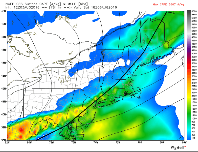
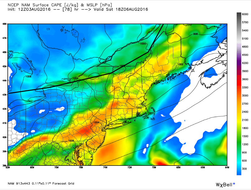
12Z GFS Showing A Fast Front And Little Instability. Image Credit: Weatherbell
Saturday has the chance to be our most active day of the next 7 as a cold front crosses the area. The timing of the front remains more or less up in the air and when exactly it crosses the region will play a big part in determining if we have a shot at strong to severe storms or not. The later in the day the front crosses, the better chance we have for strong storms. If the front crosses in the morning, look for just showers and maybe an isolated rumble. If the front crosses in the afternoon, scattered showers and storms are likely.
12Z NAM Showing A Slow Front And Plenty Of Instability. Image Credit: Weatherbell
If the front waits until the late evening to begin entering western ME and NH, a fairly widespread severe weather day is possible. The upper level dynamics (trigger and organizer) look solid, the biggest question is instability which is why the timing of the front is so important. You can see how a difference of 6 hours between the GFS (upper map) and the NAM (lower map) means the difference between tons of instability and big storms, and nothing at all. I’ll continue to analyze the pattern in the coming days and see if I can figure out exactly when that front will show up on our doorstep.
12Z GFS Showing Breezy NW Winds Drawing Cool, Dry Air In From Canada. Image Credit: Weatherbell
Sunday will bring the chance for a spot shower as some upper level energy rotates through. Cooler and drier air will be filtering in during this time on breezy NW winds. The cool, dry air will stick around for Monday and Tuesday, both of which look awesome. The comfortable weather doesn’t last long as developing SW flow looks to bring more heat and humidity as we head into the middle and latter parts of next week.
12Z GFS Showing The Pattern For The Latter Half Of Next Week. Image Credit: Weatherbell
As we’ve seen several times this summer so far, the only way to kick big heat out of New England is to bring some boomahs in so we’ll be watching for possible severe weather when that heat breaks in a couple weeks. Until then, enjoy the cool weather while it’s here, and keep cool when it’s hot. The dog days of summer are here so hit the beach while you can, winter is right around the corner and by the end of next month, snow will have sat on the slopes of Sunday River. We live in Maine, after all.
Today will feature mainly sunny skies, light winds, and warm temps as high pressure crests over the region. Look for highs rising into the low to mid 80’s for most with a few upper 70’s in the far north and along the coast. Most of us will enjoy a dry day today with the exception of the far northern mountains where an afternoon shower or storm is possible. No severe weather is expected but watch out for a stray lightning strike in that area along with brief downpours.
Warmer and more humid conditions build in for later this week before a cold front brings showers and storms Saturday. Gusty NW winds cool us off for Sunday and into early next week but by the middle of next week, heat and humidity look to be on the rise again.
Both temps and humidity will bottom out tonight for the forseeable future and we will be on an upward trajectory for the rest of the week, reaching the low 90’s in SW areas by Saturday. Saturday will be our peak in terms of both heat and humidity with upper 80’s to low 90’s in terms of temps and dew points in the upper 60’s to low 70’s. For all those who are anxiously watching the Beach to Beacon forecast, it does not look like great running weather. If you do happen to be running, feel free to say hi post race in the nearest part of the ocean. I’ll be running too.
12Z GFS With An Overview Of This Week’s Weather
The temp/dew point trace looks basically the same as it did yesterday (this is a new graph, I promise!). The theme of the next seven days will be warming to storms Saturday before cooling heading into next week. Rain will be possible Thursday and Friday afternoons in the form of widely scattered storms especially in the mountains. More widespread showers/storms are possible Saturday before scattered showers return to the mountains Sunday and then everyone stays dry into Monday. Ignore that the GFS has little rain Saturday and more Sunday, there appear to be some issues with it’s convective parameterization. I used the graphic more to illustrate the temp theme and when rain was possible.
A Peek At Saturday’s Storm Potential From The 12Z GFS
A cold front will be drifting our way Saturday as an upper level low drifts over Northern Quebec. The pattern aloft does not support widespread severe weather as there is little upper level energy (left panel) in our area when the cold front is arriving (surface map on right). The greatest uncertainty remains with the timing of this front. The lack of strong upper level energy to push the front along makes me want to lean a little slower on the front meaning it would likely come through Saturday evening from NW to SE. Some guidance has it moving through earlier in the day Saturday but as I said, I would lean a little slower for now.
Cool, dry air will be carried in on breezy NW winds Sunday which will introduce the typical upslope/downslope regime with clouds and showers in the mountains and sunny skies to the SE. Cooler and drier weather is expected to continue into the early part of next week.
Today will feature mainly sunny skies, slightly warmer temps, and the continued need for the raincoat/umbrella to be on standby. Look for high temps in the 70’s for most with a few low 80’s possible across SW NH. Much sunnier skies are expected today with just partly cloudy skies expected. The exception to this will be Southern NH and where a band of showers is currently moving through along with some overcast skies.
Radar Showing Morning Showers For Southern NH + SNE
As for precip, there will be two phases. The first phase will primarily be to our south over MA, CT, and RI where a band of showers and thunderstorms has brought some minor flooding to Springfield MA. The northern edge of that will clip Southern NH and perhaps the southern tip of York County but will otherwise remain safely south of us. The other impact that will stretch only slightly farther north will be some clouds which should move out by mid to late morning.
HRRR Model Showing Widely Scattered Showers Across ME And NH This Afternoon. Credit: Weatherbell
The second phase of precip will arrive in the form of pop up showers this afternoon. This morning’s HRRR run does a good job of showing that at any one time, most places stay dry while only a few see rain. This means that outdoor plans are a go if you’re prepared to either duck inside for 5 minutes or get a little wet should a shower find your favorite recreational spot. No storms are expected.
Expect a warming trend through late week with stifling heat and humidity returning for Friday and Saturday before storms Saturday evening usher in cool, Canadian air for the beginning of next week.
Quieter weather is in store for the next 4 or so days as the weak mess of upper level energy that has kept clouds and showers in the forecast these past few days moves slowly to the east. Expect a clearing and warming trend through the end of the week with uncomfortable heat and humidity returning by Friday. Showers and storms are again likely Saturday as a cold front moves through. The timing of that front remains uncertain and just how strong those storms get will depend on exactly when that front moves through. More details will become available as the week goes on and I’ll pass those along as soon as I figure them out.
12Z GFS With A Look At The Week Ahead
Since the weather looks fairly quiet until the highly uncertain forecast next weekend, this will be a fairly quick post. The 12Z GFS shows the general trends over the next week with cool and cloudy conditions now (grey/green on the far right) giving way to clearing and warming towards the end of the week. The red line is the temp trace and I added the purple arrow to show temps increasing with time (time goes from right to left on this graphic with the right hand side being now and the far left being next weekend). Temps and humidity (green line) peaks Friday (purple box) before cooling off towards next week (note descending temp trend at the far left of the image). The biggest chance for precip will be Saturday with those potential storms. Gusty NW winds are likely to usher in a period of cool, dry weather for early next week.
Today will feature mainly cloudy skies, light ENE winds, and the continued chance for showers. A band of rain is moving E across south-central VT this morning and will continue to meander in our direction through the morning and heading into this afternoon. That band of rain will be weakening as it moves away from the most favorable upper level dynamics but it will bring steadier rain into the forecast for at least the southern half of the area. Farther north and east, scattered showers are expected to pop up and down all day with the best chance towards the midcoast where a few showers are currently being reported. A light but steady onshore wind will keep temps cool and drizzle/fog in the mix for most of the area. Highs will only get into the low 70’s at best with some areas stuck in the upper 60’s. Far northern areas may see a little bit of sun but otherwise overcast conditions are expected.