Very Active Pattern Incoming

Hello everyone!

We’re now locked into what looks to be an extremely active pattern for cold and snow with today’s system wrapping up tonight, a clipper system bringing light to moderate snow Saturday, a coastal storm potentially bringing a major snowstorm Monday, and another coastal storm threatening in about a week. I’ll go over what we know, what we don’t know, and some of the mechanics behind each storm below. Welcome back to winter!

HRRR Model Showing Snow Winding Down This Evening. Credit: Weatherbell

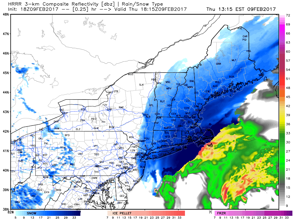
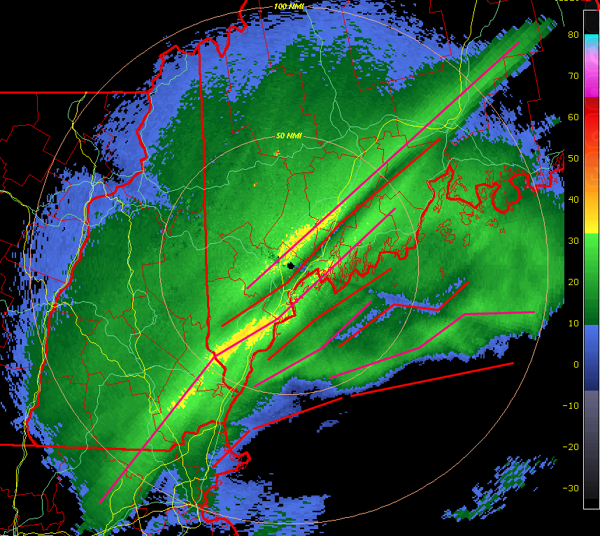
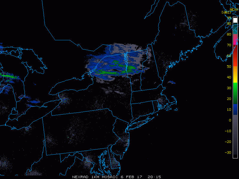
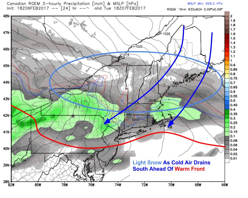
The current storm will wind down this evening as the coastal storm moves offshore. Here’s a simulation of what that will likely look like from the HRRR model. There was plenty of mesoscale banding today, for some of the science behind that phenomenon, check out my post from this afternoon. An additional several inches of snow are expected before things wind down later this evening. Gusty NW winds will bring in very cold temps for tonight and tomorrow resulting in very low (subzero) wind chills and the continued threat for blowing/drifting snow.

18Z NAM Showing Light Snow Saturday Afternoon. Image Credit: Weatherbell

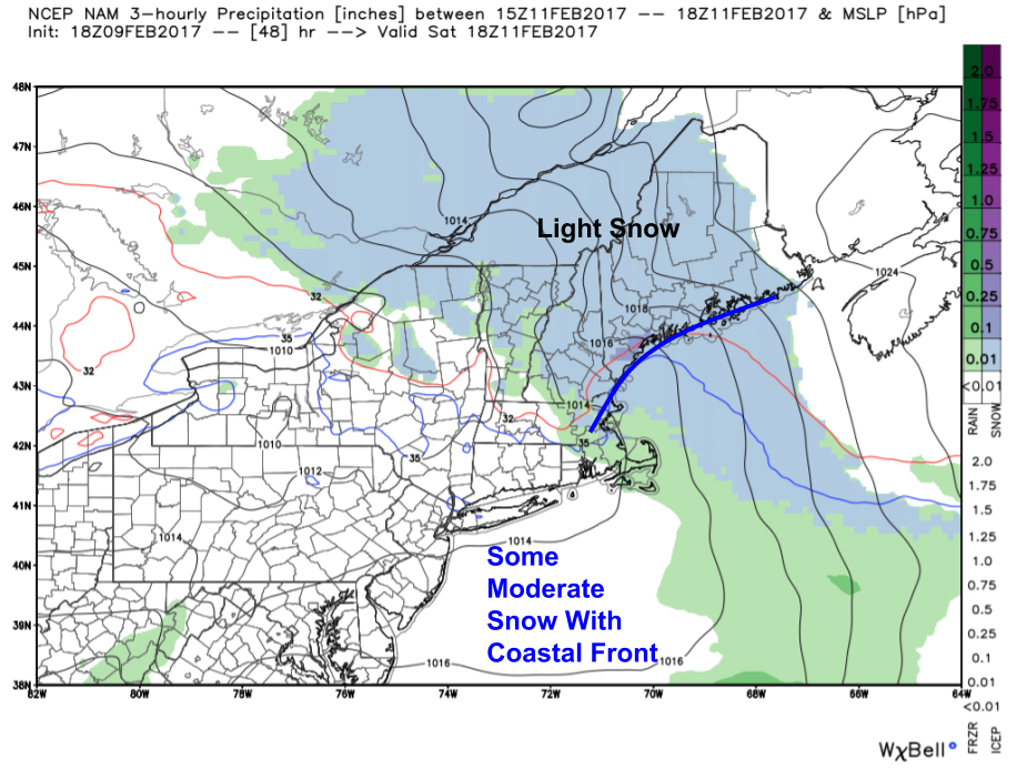
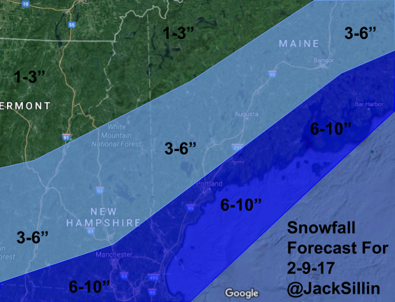
Light snow will develop early Saturday morning and will continue through the day. Snow will be light for most but a little coastal front/mesoscale low pressure system will likely enhance snowfall along the coast. Most folks will end up with 1-3″ though the coast is likely to see 2-4″. With the fluff factor in place due to cold air, there’s an outside chance someone ends up with 6″ but that seems unlikely at the moment. Snow will taper off Saturday night.

12Z GFS Showing An Upper Level Setup Favorable For Rapid Intensification Monday. Image Credit: Accuweather

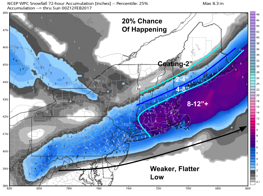
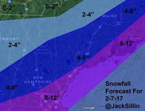
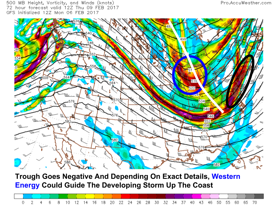
Our next system will take shape Sunday night into Monday. Considerable uncertainty still exists though if current forecasts from guidance verified, we would be in for a major snowstorm. All the typical threats are looking likely with heavy snow, high winds, and coastal flooding all on the table. This storm has the potential to rival some of the blizzards of the past few years so stay tuned to the latest updates as confidence increases. Of course it wouldn’t take much of a change in the timing of a couple disturbances to result in a much more benign event though at the moment that looks unlikely.

Depending on the intensity of the system, snow could linger into Tuesday before moving out. We’ll have a break for most of the day Tuesday before another storm threatens for Wednesday into Thursday. With such a chaotic pattern, it’s far too early for amounts but it’s definitely something to keep an eye on as our active pattern rolls on!

Various Teleconnections Showing Active Weather Continuing For The Next 2 Weeks And Possibly Beyond. Images From CPC.

Looking farther out into the future, the pattern across both the tropics (MJO, top left) and the Northern Hemisphere (PNA, AO, NAO, right column) show a pattern favorable for New England snowstorms though at least the next two weeks. While it’s impossible to pin down individual threats past 7 days and it’s entirely possible that for any given threat the pieces don’t come together just right for a major (or even minor) storm, it does look like we’re in for a good little ride as we let the rest of February go by. Buckle up and enjoy the show!

I sadly will be preoccupied tomorrow evening with a most unworthy pastime (5 hour indoor track meet, ugh!) but I’ll have more this weekend.

-Jack

Why Is It Snowing SO Hard?

Hello everyone!

As our storm today continues dumping heavy snowfall across much of the area, I figured I’d take some time to explore mesoscale banding: the reason why some towns will be buried in snow today and why others right nearby will see much lighter amounts. The atmosphere is set up perfectly for mesoscale banding which makes this a great time to learn about the phenomenon.

Radar Showing Intense Banding Late This Morning. Image Credit: COD

Here’s one of the best examples of mesoscale banding you can find brought to you by today’s storm. Snow was coming down at rates of 2-4″/hour over Portland and Lewiston in the heavy bands (purple lines) while at my house in Yarmouth, we got a measly .4″ during the same period (11AM -12PM). Even better, these bands hardly moved throughout the morning and aren’t going anywhere as of this writing at 1 PM meaning there will be intense snowfall gradients as some downs hit the jackpot and others miss big. What causes these intense bands and why do some so close to the jackpot miss out?

700mb Analysis Showing Intense Convergence And Frontogenesis Setting Up Mesoscale Banding Environment. Image Credit: SPC

The answer lies in the dynamics in the mid levels of the atmosphere, roughly 10,000 feet above our heads. Way up there, a low pressure system is developing and ahead of it winds are shifting from SW to S to SE. This is pushing warm, moisture laden air west into the cold airmass and creating a warm front (frontogenesis- creation of a front). This process involves the sharpening of the thermal gradient as well as convergence, both of which favor strong upward motion focused along the axis of the front itself. Why is upward motion maximized along frontal zones? For that we turn to isentropy.

Cross Section Across Coastal New England For This Morning Showing An Elevated Warm Front. Image Credit: Accuweather

As the warm front sharpens and develops through the mid levels, air parcels rushing in from the east/south east hit a wall of cold air. The sharper and steeper that wall is (e.g. the stronger the frontal zone), the faster they have to rise as they are bound to their potential temperature surface. Potential temperature is the temperature that an air parcel (basketball sized chunk of air) would reach if it was dropped to 1000mb (air warms as it drops). There are “surfaces” of potential temperature in the atmosphere and air parcels are bound to that surface in that they rise or fall based on the level of that surface in the atmosphere. In frontal zones, the slope of these surfaces become very steep forcing air parcels to rise steeply resulting in intense upward motion.

300mb Analysis Showing Intense Divergence Aloft. Image Credit: SPC

This whole process is aided by the explosive development of the surface low off the Mid Atlantic coast and by the fact that the explosively rising air can be vented quickly away by upper level divergence. With winds blowing away from each other in the upper levels, a void is left forcing air from below to rise to fill the area of lower pressure. This helps continue the explosive upward motion. The divergence is enhanced by jet streak coupling where the left exit region of one jet streak overlaps the right entrance region of another. Now that we’ve discussed all the things that go into creating heavy snow bands, why are some missing out?

mesoscale-banding

If you look at the radar image at the top of the post you’ll notice that for every powerful snow band, there’s an equally powerful lull. What goes up must come down which results in sinking motion that suppresses snow. That’s why some folks get nailed with the crushing snow bands and others escape with only moderate accumulations.

These bands are notoriously hard to predict and can make the difference between 6″ and 12″ for any one place. That’s why we give you the ranges in snowfall forecasts- you could end up under a heavy band and get the upper end of the range or it could go the other way. Be prepared for both!

-Jack


Quick But Intense Storm Today

Hello everyone!

Today will feature cloudy skies, cold temps, and, depending on location, heavy snow. For all the details on specifics/dynamics etc. check out Tuesday evening’s update and for a more general forecast overview, look at last night’s post. Here’s the barebones snapshot. Snow will move in this morning from SW to NE in time for the tail end of the AM commute (if you’re unfortunate enough to have to go to work, go early. you’ll want to leave early too). Snow will become heavy in the afternoon hours with rates of 1-3″/hr at times. Winds will be increasing during the day out of the north so expect blowing and drifting to further reduce visibilities this afternoon. Blizzard conditions are expected along the coast though their duration will be too short for official criteria (need 3hrs+ of 35mph winds and 1/4mi visibility). Snow tapers to snow showers this evening before everyone is dry tonight. Temps will be falling through the 10’s into the single digits.

-Jack

Living On The Edge

Hello everyone!

Today’s update will focus solely on the storm tomorrow. The current thinking is that I’ll have time tomorrow evening to analyze our next few storm threats. With that in mind, let’s dig into what is an interesting and dynamic system for the day tomorrow. We will be right on the edge of a rapidly intensifying coastal storm as it moves from the waters off the mid atlantic past Cape Cod and on towards Nova Scotia. There will likely be a sharp gradient associated with snowfall amounts meaning that any shift east or west will have major ramifications for the forecast.

Since I’m short on time, I’ll quickly go through each of the three scenarios: high end snowfall, low end snowfall, and the current forecast.

WPC Probabilistic Guidance Showing Reasonable "Best Case" Scenario. Image Credit: Weatherbell
WPC Probabilistic Guidance Showing Reasonable “Best Case” Scenario. Image Credit: Weatherbell

The first scenario is that the storm doesn’t quite develop in time or the upper level trough can’t pull it back as far west as forecast. This would result in less snow. I doubt this will happen due to the orientation of the upper level trough (very negative with SE winds to feed in moisture)  as well as the current observations of the storm which are in line with the stronger/farther west guidance so far. However, what goes up must come down and it’s possible that part of the area will get stuck in a subsistence zone as powerful snow bands blast SNE. This would also result in these lighter snow totals. Notice though that even with the lighter outcome, Portland is still likely in for a 6″ snow event.

WPC Probabilistic Guidance Showing The Most Likely Scenario. Image Credit: Weatherbell

Here’s what the WPS thinks is most likely and my thinking (shown in my official snow map below) is fairly close to this idea. The storm will deepen rapidly off the Mid Atlantic coast and move NE towards Nova Scotia. This would result in a fairly substantial snowfall event along the coast with some spots likely seeing up to a foot. The mountains would see lighter amounts with only around 2″ up by the Canadian border.

WPC Probabilistic Guidance Showing A Reasonable "Worst Case" Scenario. Image Credit: Weatherbell
WPC Probabilistic Guidance Showing A Reasonable “Worst Case” Scenario. Image Credit: Weatherbell

Here’s a look at what could happen if things develop a little more quickly. Much of the area would see a serious snow event with much of the coast coming in at right about a foot. Right now this does not look likely but given the steady NW trend in guidance, it remains on the table as a possibility. Dendritic growth parameters give us the green light for fluffy snow that will accumulate quite quickly as the day goes on tomorrow so even with low liquid equivalent, ratios will be the friend of those rooting for heftier snowfall totals.

My Forecast
My Forecast

Here’s my forecast for snowfall tomorrow. Guidance is hinting at a band of heavy snow developing over the coastal plain tomorrow afternoon and before that a band of heavier snow over the mountains during the morning hours resulting in the 4-8″ forecast up there. There may be a lull of lighter totals just away from the coast where subsistence between these two bands results in sinking air and lighter snow.

More tomorrow morning on this storm (we’ll know by then which scenario we’re heading for) and tomorrow evening on all the other storms headed our way in the next 7-10 days (there are a bunch!)

-Jack

A Slick Start, A Springy Middle, And A Colder Finish

Hello everyone!

Today will feature three distinct periods. The first of winterlike cold and freezing rain is ongoing right now with temps in the 10’s for most, even along the coast. Precip is on its way out and an approaching cold front will result in this period ending mid morning. The turbulence with the cold front will mix down very warm air just over our heads which will result in a second, very mild spring like period today. It will last from mid morning to mid afternoon and feature temps in the 40’s to near 50 along with a few sunny breaks here and there. After the cold front passes through, the third phase begins with gusty NW winds and temps dropping back below the freezing mark tonight.

More snow is on the way tomorrow, read all about that threat in last night’s update.

-Jack

An Active Stretch Of Weather Begins

Hello everyone!

Today’s snowfall is kicking off an active pattern for at least the next 10 days. Snow will change to a messy mix tonight before moving out tomorrow morning. Temps will fall from near 50 Wednesday afternoon to right around 20 by Thursday morning as snow moves in associated with our next system. After some wind blown fluff Thursday, we’ll get a day off Friday before a clipper system approaches Saturday. Sunday morning will be the calm part of the weekend before more snow/mix arrives with a system Sunday night into Monday morning. Another system may be showing up on the horizon for the middle/latter part of next week but it’s too far out to say what any potential impacts from that may be.

This current system has been slightly misbehaved, the first round having arrived and departed early while the second round dragged its feet in getting here. There wasn’t a lot of data that supported a break in the action today but it happened going to show you that despite our best efforts as forecasters, mother nature is the one really in charge.

HRRR Model Showing Snow Intensifying And Changing To Sleet/Freezing Rain Tonight Into Tomorrow Morning. Credit: Weathebell

The rest of this storm does look to be fairly straightforward with the only major challenge yet to figure out being the timing of the freezing rain -> rain transition. Based on the above model simulation, it appears as though that may not occur until after most if not all the precip has left though other guidance suggests the coastal plain may warm up before then. Either way, a period of ice is likely to make the morning commute slick but temps in the 50’s will make sure any icy spots melt away for the PM commute. After that, temps take a nosedive after dark and end up back in the teens for Thursday morning. That’s when the next round of fun starts.

12Z GFS Showing A Near Perfect Setup For A Large Coastal Storm Thursday. Image Credit: Accuweather

Everything starts at 500mb when it comes to coastal storms and all signals are pointing to a fairly impactful event. The all important trough orientation is forecast to be negative meaning the slope of the trough axis is negative. This allows for the energy that forms the storm to pull out ahead of the main trough where S/SE winds can push it right up the coast. The 500mb pattern is extremely conducive to a more westerly storm track which is why I’ve gone towards the upper range of guidance for snow totals (see map below).

12Z GFS Showing A Jet Stream Pattern Favorable For Rapid Intensification. Image Credit: Accuweather

The jet stream will be oriented in such a way that rapid intensification of the low is supported. While not textbook, there will be two jet streaks coupling to create enhanced divergence in the upper levels as we go through the morning Thursday. Notice the overlap between the right entrance region of the poleward jet and the left exit region of the equatorward jet. This is the area in which divergence is maximized. It lines right up with the coast of New England which is another factor that would support a low track closer to the coast.

12Z GFS Showing Lots Of Upward Motion In The Area Thursday Afternoon. Image Credit: Accuweather

Looking towards the mid levels, the exact placement of strong upward motion will determine who gets the heaviest banding. The jackpot is currently forecast to reside over MA and SNE leaving us with moderately heavy snowfall as opposed to very heavy snowfall. However, a tick NW in the storm track as supported by the 500mb maps would mean those heavier bands would move in our direction. There’s a fine line to walk here and I suspect we’ll have more confidence by the time tomorrow rolls around.

Forecast Snowfall For Thursday

Here’s my thinking for total snowfall Thursday. There’s room for these numbers to go up depending on the exact track. I also think this storm will follow the typical pattern of sharp gradients on the NW edge so a downward adjustment is possible across the mountains. I’ll finalize these numbers tomorrow.

12Z GFS Showing Our Next System Saturday. Image Credit: Weatherbell

Snow will move out Thursday evening leaving a cold and breezy but dry Friday. By Saturday though a clipper system will approach from the west bringing with it more snow. This system looks colder than the one today and lighter than the one forecast for Thursday. A general 1-3″ looks to be a solid early guesstimate on accumulations as guidance is fairly locked in at this point. A little coastal enhancement could develop Saturday night which may result in some moderate snow but otherwise this looks like a fairly benign system.

12Z GFS Showing Another Storm For Sunday Night Into Monday. Image Credit: Weatherbell

The clipper will move out Sunday morning leaving about 12-18 hours of calm before our next storm arrives Sunday night. This one will track right over us, approaching from the west then redeveloping offshore. The exact timing/details have yet to be determined but we have cold high pressure in place and a sharp frontal zone to our south so this one looks fairly likely to cause some trouble as we begin the next week. We’ll discuss amounts as we get closer.

The next storm in our parade is scheduled for the second half of next week but is way too far out to discuss potential timing/impacts/amounts. We’ll keep an eye on it as we get closer!

Beyond that, all indications are that we stay in an active pattern for at least the next couple weeks. Welcome to winter’s comeback!

-Jack

Moderate Snow Becoming Heavier Today

Hello everyone!

Today will feature light to moderate snow this morning becoming heavier by this evening. Look for 3-6″ to pile up through the day with a couple more possible tonight up in the mountains. Snow will change to sleet from SW to NE late in the evening putting an end to meaningful accumulation. Temps will slowly rise from the 10’s this morning to the 20’s by this evening. For all the details/analysis for this storm, check out last evening’s writeup.

More snow on the way Thursday, Saturday, and Sunday/Monday. Seeing as I’m off school today, I’ll have info on each system in this evening’s update.

-Jack

It’s Comeback Time

Hello everyone!

Last night we witnessed the greatest comeback in Superbowl history and over the next 7 days we’re likely to witness a robust comeback in terms of winter weather. An icy storm will bring snow, sleet, and ice to the region tonight through Wednesday. This will be quickly followed by a storm threat for Thursday as colder air pours into the region. Lighter snow is forecast for Saturday before another mess takes shape late in the day Sunday into Monday. Welcome back to winter!

Seeing as we have many storms in the forecast and I’d like to get this done by midnight, the analysis for each storm won’t be as beautifully detailed as I might like. Hopefully we can pull a snowday out of the hat tomorrow for more detailed coverage.

Mess #1- Tonight Through Wednesday Morning

Radar Showing Light Snow Approaching This Evening. Credit: COD

A weak upper level disturbance will approach tonight and in advance of it, snow will break out. There’s lots of dry air for this system to overcome and so I don’t expect much snow to actually make it to the ground until later this evening for NH and later tonight/early tomorrow morning for Maine. Snow will continue through tomorrow before changing to sleet/freezing rain tomorrow night and into Wednesday morning. Expect right around an inch on the ground by the time the commute arrives tomorrow morning.

18Z RGEM Showing Light Snow During The Day Tomorrow

Light to moderate snow will be the rule for most of tomorrow as warm air moves up and over the cold air near the surface. The main low pressure system will track well to our west though a secondary wave of low pressure will develop along a bump in the warm front near Cape Cod. This will keep those NNE winds going strong keeping cold air locked in place at the surface. As the warm air advection aloft intensifies, precip will too. We’ve already gone over how heavier precip keeps cold air in place due to latent heat transfer from phase changes (melting precip cools air as snowflakes require energy to move from solid to liquid state) however strong WAA will eventually overcome this process aloft changing precip over to sleet and freezing rain.

12Z NAM Cross Section Valid 7 PM Tomorrow Showing An Elevated Cold Frontal Surface With Warmer Air Aloft. Image Credit: Accuweather

As evening approaches tomorrow so too will warm air in the mid levels of the atmosphere. This cross section from VA (left) to NB (right) goes right through Maine (middle/right) and shows a cold frontal surface to facilitate overrunning precip tomorrow as well as a change to mixed precip tomorrow night. Warm air being forced up and over this low level cold dome will give us the snow tomorrow and the warmth eventually becomes warm enough to melt the snow into sleet and freezing rain.

18Z NAM Showing Warmth Aloft And Cold At The Surface Leading To Sleet/Freezing Rain Early Wednesday Morning. Image Credit: Weatherbell

Here’s what the result of that process looks like early Wednesday morning. Notice the warmth aloft has made it well north into Canada and a secondary low pressure system off Portland is locking in the cold at the surface. As a result, look for an icy mix to last into the morning commute Wednesday even along much of the coastline. The exception will be in the usual spots along the midcoast where the secondary low could mix up the atmosphere enough to draw down some of the warmer air aloft.

18Z RGEM Showing The Setup Wednesday Morning. Image Credit: Weatherbell

The event ends Wednesday with a temperature roller coaster along with slick travel for the morning commute. As the deeper moisture and best dynamics lift off to the NE. we’ll be left with freezing drizzle for the morning commute Wednesday. Temps will rapidly jump up into the 50’s for a few hours around noon Wednesday for most (possibly excluding the northern mountains) as the warm front lifts north and the cold air dam mixes out. The cold front will put a quick end to the spring like temps Wednesday evening as temps will quickly drop back below freezing. The refreezing of any water/slush on Wednesday evening will be something to watch as a potential hazard for the Wednesday evening commute and/or the Thursday morning commute. Black ice will be something to watch for in that timeframe.

12Z GFS Showing Upper Level Potential For A Coastal Storm Thrusday. Image Credit: Accuweather

Our next storm will develop right on the heels of our Tuesday-Wednesday mess. The cold front that will put an end to our brief few hours of spring weather will stall out over the Mid Atlantic and incoming Pacific energy will form a storm along the front Wednesday evening. Exact interactions between all the various disturbances will determine if that storm intensifies up the coast resulting in a sizeable snow storm or if it zooms harmlessly out to sea. Right now, I’d lean towards a light/moderate snow event beginning Thursday morning and ending Thursday evening. The best chance for several inches of snow will be along the coast though even there, dustings could be the upper limit if the storm tracks a little farther out to sea.

Looking past Thursday, a light snow event is in the works for Saturday with another messier system for Sunday night into Monday. More details on those as we go through the week.

-Jack

Turning Colder Today

Hello everyone!

Today will feature a temporary return of our NW wind pattern as a cold front moved through last night. This time, however, real cold air is set to move in as opposed to that pseudo cold behind last week’s fronts. Temps will start in the 20’s to low 30’s this morning before falling into the 10’s/low 20’s by this afternoon. Skies will start mainly sunny but will gradually turn cloudier as our next storm system approaches. I hope to have a more detailed update on it this evening.

-Jack

Cool And Unsettled Weather Continues

Hello everyone!

Our WNW wind pattern will finally be broken today as a clipper system moves to our north. Look for slightly milder temps along with more clouds and SW breezes. Some snow showers will be scattered about the north country where an inch of accumulation is possible in spots. Things are expected to remain mostly dry in the south. Highs will range from around 20 in the north to right around freezing along the coast.

Messier weather arrives Tuesday morning but as a result of Patriot domination forecast this evening, my full update on that will be pushed back to tomorrow night.

-Jack