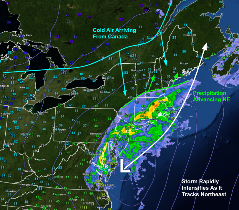
Our next storm will arrive today and kick off a pretty exciting week or so of weather here in New England.
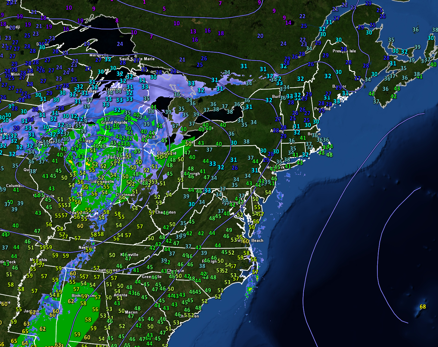
Today’s storm of interest is currently located near Chicago as the analysis map above shows. There’s plenty of precipitation associated with that system, but it’s actually going to move mostly to our north as the low heads towards Ottawa. It’s the scattered showers visible between Cape Hatteras and Long Island that will end up dropping most of today’s precipitation in our area as they move up the coast late this afternoon into this evening.
Any morning glimpses of sunshine will be brief as clouds continue to arrive ahead of this storm.
Forecast radar imagery shows rain arriving in southern NH between 2-4 PM before moving into southern Maine around 4-6 PM. Despite our northeasterly winds, precipitation types will be rain outside of the mountains and foothills (though perhaps a few flakes/ice pellets might mix in right at the beginning of precip near Augusta-Waterville). Up in the mountains, an initial burst of snow could drop up to an inch or two before changing over to sleet/freezing rain.
Rain will continue through most of tonight along the coast while freezing rain remains the predominant precipitation type north of Route 2. Thankfully it looks like total ice accretion should remain in the 0.1-0.25″ range which usually isn’t enough to cause major power outage problems. Temps will warm up above freeing across the whole area tomorrow so slick travel tonight appears to be the biggest impact from this freezing rain.
Warmth tomorrow will give way to cooler temps on Monday along with some potential snow along the coastal plain. The coldest air of the season so far will then pour into the region on Tuesday ahead of what might be a more significant winter storm midweek.
High pressure has now crossed east of our area which means that winds will turn around to the southwest today. Naturally this means we’ll expect warmer temps and some sort of unsettled weather as warm air dislodges previously-established cold air. For most, that unsettled weather will come in the form of overcast skies though a couple showers/flurries are possible way up in the mountains. High temps today will range from 35 up in the mountains to 40 for most of the area to 45 in southern NH where a few breaks of sun are possible.
Our next round of precipitation will arrive from the southwest tomorrow evening falling as rain along the coast and freezing rain in the foothills/mountains.
Today will feature sunnier skies and warmer temps as yesterday’s weak clipper system moves away to the east and high pressure begins building into the region from the west. Northwesterly breezes between the high and low will force our usual upslope/downslope pattern with clouds locked in along/northwest of the mountains and sunnier skies along the coastal plain. Temps and precip will follow the usual patterns too with highs around 30 under snow showers in the mountains while 40-45F temps are expected along the coast with dry conditions (after a couple morning flurries depart the Midcoast area).
Overall, our weather pattern looks fairly quiet until our next storm arrives Saturday afternoon/evening. This one will be headed to our west so snow will be confined to far northwestern parts of the area. The challenge will be nailing down the transition zones between rain along the shoreline, freezing rain inland, and sleet/snow way up north. Right now, this looks to be more of a nuisance ice event than a damaging ice storm but I’ll be keeping a close eye on things in case that looks to change.
Today will feature cloudy skies and light snow as a weak clipper system moves across the area. The clouds are already here this morning for most of us, though eastern parts of the area might get a glimpse of the sun as it comes up over the next hour or so. Snow is just starting to arrive in far western NH and will spread east through the day.
This forecast loop shows the expected progression of snow today. While most if not all of the area (except perhaps far southern locations) should see at least a few flakes, snow will be steadiest up in the mountains which is where 1-3″ is expected. For the rest of us, a coating-1″ is probably all we can squeeze out of this one as it lacks substantial moisture. Nevertheless, take it slow on the roads if you’re out and about this evening. Some slick spots will pop up even closer to the coast.
High temps will range from around 25 up north to around 35 along the NH Seacoast.
Today will feature the passage of another nor’easter except this time, the storm will track too far east to bring precipitation to the area. Instead, we’ll get another round of northerly winds, cool temps, and plenty of cloud cover. High temps will range from around 20 up north to just above freezing right along the coast. Northerly winds will be strongest along the Midcoast but shouldn’t gust more than 20 or 25 mph so no issues are expected.
Our departed nor’easter will retain primary influence over our weather today as it spins itself out over the Gulf of Saint Lawrence. That means that northwesterly flow will continue to bring cooler air into the region from Canada.
This airmass can actually be traced back to the Pacific Ocean about 10 days ago so while its time over northern Canada certainly helped cool temps down a bit, this is not frigid Arctic air by any means. With that in mind, we’d expect our temps today to be seasonably cool but not much colder than that. Sure enough, model guidance is showing high temps in the upper 20s up north and the mid/upper 30s along the coast this afternoon.
With NW flow continuing, clouds will remain locked against the higher terrain while the foothills/coastline enjoy mostly sunny skies. Overall, today’s weather will be quite similar to what we saw yesterday except perhaps more sunshine along the coast and a little bit less in the way of snow shower activity up north.
It is not customary for me to send out an update in the afternoon, but since I had a few minutes, I wanted to give those interested a look into my forecast verification process. Perhaps you don’t need me to remind you that I made a few mistakes with the forecast for our snowstorm yesterday. Much of the area didn’t see as much snow as was forecast. An important part of becoming a better forecaster is identifying and learning from errors like this so hopefully they don’t get repeated in subsequent forecasts. With that in mind, let’s take a little trip back to see what happened yesterday and what clues to look for ahead of time when our next nor’easter appears on the horizon.
The large-scale forecast actually wasn’t so bad. We got our big nor’easter as the two jet stream disturbances joined forces. The storm rapidly intensified, just about exactly as much as was predicted. The storm’s track forecast was also pretty much on the money as the surface low raced from the Delmarva to Cape Cod and eventually over towards Eastport Maine. Yet as is often the case, the devil is in the details and the smaller-scale processes embedded within our storm proved quite fickle.
We’ll start with an overview of how much snow fell compared to how much was forecast during my morning updates on 12/4 and 12/5. At first glance, the broad contours of the forecast don’t look so bad. The lowest amounts were found near the coast and especially along the Midcoast. Lower totals were also found and expected along the CT River over in western NH. The jackpot was up in the Whites and the mountains of western Maine, though the analysis data I used to produce the observed plot seems to be leaving out some of the 15-18″ reports from Rangely and Carrabassett Valley. Once you look a little harder though, it’s clear that for most, I was about one category too high. Most inland areas expected to get 8-12″ actually picked up 4-8″ for example. Then there were two spots where things got really ugly: Central NH south of the White Mountains (expected 12-18″, got 0-2″) and the Midcoast just north of Route 1 (expected 4-8″ or 8-12″, got around 2-4″).
So what went wrong?
This cross-section, taken from a model forecast issued Friday morning, provides some clues. This cross-section intersects both of the areas that busted hardest. With the benefit of hindsight, it’s clear that the model was flashing some warning signs that went unheeded. Strong downsloping (positive omega values = downward motion) south of the Whites led to warming and drying of the air there. With temperatures already near freezing at the surface, it didn’t take much of a topographical influence to make snowfall accumulation near impossible here. While we don’t often see such a dramatic topographically-induced snowhole, it’s clear that extra attention needs to be paid to the mountains when the environment is so marginal for snow to begin with.
Farther east over the Midcoast, a layer of warm air (above freezing) aloft is noted from around 900mb (~1500ft) to around 850mb (~5,000ft). This is a separate layer from the warmth right at the surface which only extends a couple hundred feet up. While winds near the surface were quite strong from the north, winds in that layer a couple thousand feet up had a strong easterly component. That means warm air was moving in from the Atlantic rather than cold air from Canada.
Running a backwards trajectory plot using old model data confirms this intuition. Air parcels 3,000 feet above the ground over Bath last evening started out over the Gulf Stream a couple days ago. While they cooled on approach to the Maine Coast, it just wasn’t enough to keep that part of the area all snow.
When looking at forecast model data ahead of the storm, I was wondering why guidance seemed to be pushing the rain/snow line inland during the 5-8 PM timeframe when winds near the surface were increasing from the north, the sun was setting, and intense lifting would surely favor dynamic cooling of the thin near-surface warm layer. The answer it seems was that during this time, there was a surge of warm air aloft that developed in response to the same jet stream dynamics supporting our heavy precipitation. While dynamic cooling can easily blast through shallow warm air near the surface, especially with winds from the north, it’s a lot harder to offset a thick layer of warm air aloft that’s being reinforced by a steady east/southeast wind.
We can see hints of this in the weather balloon data gathered at 7 PM yesterday by our friends up at the NWS office in Gray.
The layer of warm air a couple thousand feet up appears clearly on this sounding, even though Gray was west of the rain/snow line. If the balloon were launched from Brunswick or Bath, it surely would show a layer of above-freezing air here.
The sounding is also interesting because it sheds some light on why the rest of the area, on the correctly-predicted side of the rain/snow line and away from any discernable downsloping, didn’t see quite as much snow as we expected. The classic six-sided snowflakes that accumulate most efficiently form between temperatures of -12 and -18 Celsius. To get lots of these snowflakes, we want the layer in which they form to be deep, moist, and stocked with strong upward motion. Otherwise, we’ll end up with plates or needles that don’t stack up nearly as well. On the GYX sounding from last night, we can see the -12 to -18C layer is really high (around 15-18,000ft) which is well above the layer where we were seeing the best upward motion (estimated around 10,000ft). So we weren’t getting the best snowflakes to begin with. Then, as those snowflakes fell, they were warmed to near freezing by that layer discussed above. While this didn’t melt the flakes, it did prime them to melt more easily when they came in contact with warm surfaces. So unless it was snowing really hard, we weren’t getting much accumulation.
This was actually depicted pretty well by model guidance ahead of time. The sounding shown here, off the Friday morning NAM run, shows pretty much exactly what happened in the Gray area. Dendritic Growth Zone (DGZ) was high/thin and there was a nose of near-freezing air near 800mb (~6,000ft). I actually looked at several soundings like this before the storm but decided to mentally cool things down a bit to adjust for a known bias in the NAM to generally be too warm in situations like this (due to some issues with how it handles thunderstorms).
As it turned out, this was actually a good move!
If you look carefully at the NAM forecast for this time, it shows rain all the way up past Augusta/Waterville and over to Windham, all locations that were experiencing snow at the time. So betting on the NAM to be too warm was the right call, I just overdid the correction.
At the end of the day, hindsight is 20/20 and what’s obvious now was a lot less obvious before the outcome was known. As with any storm, particularly one where my forecast wasn’t so great, the lessons learned will help improve the forecast for our next nor’easter, whenever it may come. I’ll be watching extra closely for localized downsloping and I’ll run a few trajectory analyses ahead of time to see if there might be any sneaky warm layers. I adjusted snow:liquid ratios down quite a bit from the standard 10:1 in light of our warm surface temps, but I’ll be adjusting downward even more if we have poor snow growth and that layer of near-freezing air aloft to prime the snowflakes for melting on contact with the ground.
Thanks to all those who still follow along despite the missed forecasts here and there along the way.
Yesterday’s storm is on its way out this morning and cool/breezy weather will take its place today. Our breezes will be from the northwest so coastal areas should see some breaks of sun while the mountains remain stuck under low clouds and some flurries. High temps today will range from the upper 20s up north to the upper 30s right along the shoreline. NW winds could gust up to 30 mph at times, which may slow power restoration efforts a bit in some spots. Otherwise, it’s back to quiet weather around here for a while.
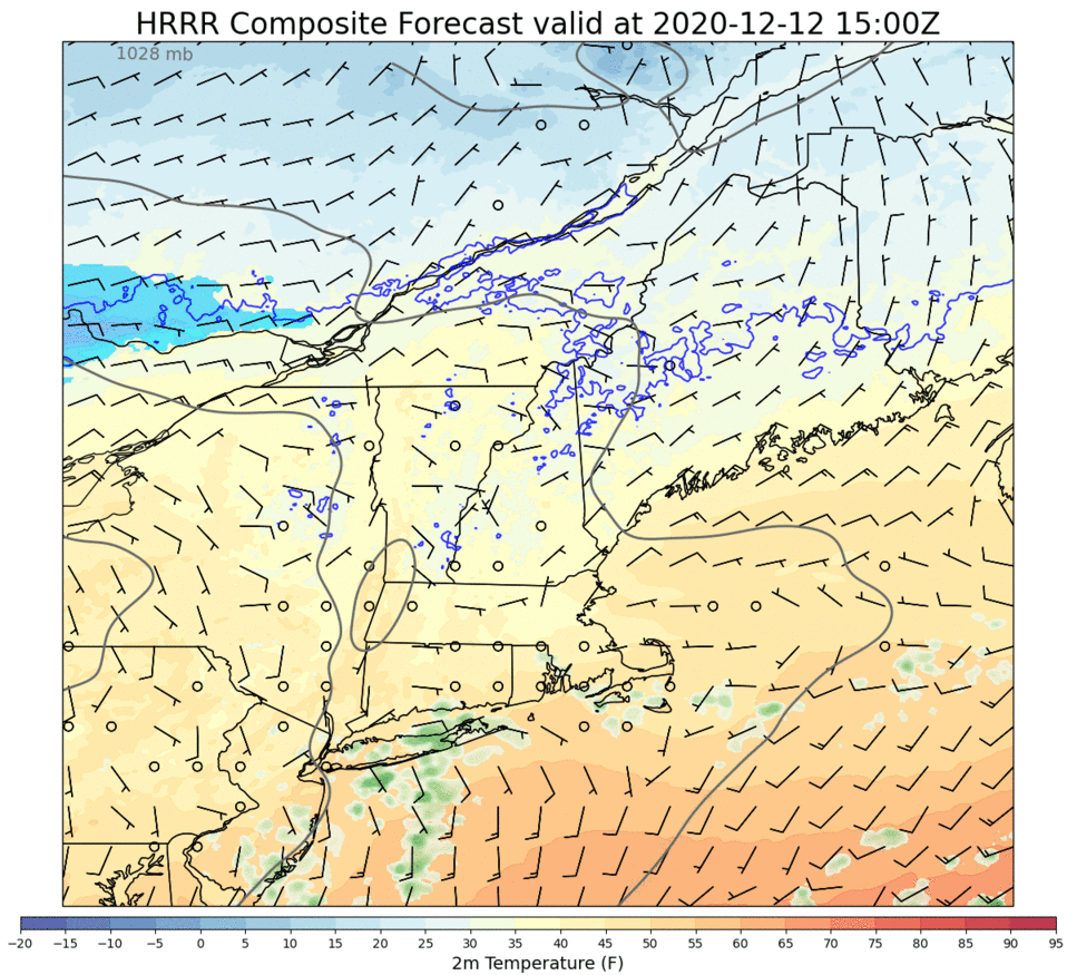
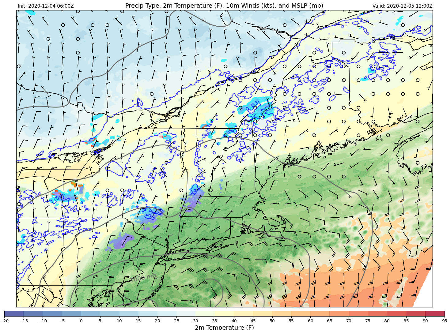
The powerful nor’easter I discussed yesterday is rapidly developing over the Delmarva this morning. While temps across the region this morning are warm enough to keep the precipitation type forecast tricky, cold air is en route from Quebec to assist in changing morning rain over to afternoon snow.
Here’s a quick look at temperature and radar observations as well as sea-level pressure analysis data. You can see from the temperature obs (numbers representing temps at each observing station) that most of us are above freezing in ME/NH this morning but much cooler air is lurking just to our northwest in Quebec. As our storm intensifies today, that cold air will be drawn southward and will help change precipitation from rain over to snow.
Precipitation will overspread the region from south to north this morning and will initially fall as rain for most.
This loop shows model forecast precipitation type (green = rain, blue = snow) from 5 AM to noon. Note that by noon, it’ll be raining fairly heavily along the coastal plain and pockets of snow will begin to develop in response to a process known as dynamic cooling.
For those curious, the basic idea behind dynamic cooling is that if you have enough upward motion in the atmosphere producing heavy precipitation in a near-freezing environment, two thermodynamic processes will team up to drive temperatures down to around freezing, changing rain over to snow. The first is that as air rises, it expands and pushes against the air around it. The energy used for this pushing comes at the expense of the air’s thermal energy which means the air cools off. The second process is associated with latent heat transfers as billions (trillions?) of snowflakes fall into the warm air near the surface. Once they encounter temps above freezing, those snowflakes start to melt. When they do, they’re taking energy away from the surrounding air to be used for the phase change. Because energy must be conserved, the air then ends up colder.
Now that we’ve gotten our daily dose of thermodynamics, what does this all mean for the forecast?
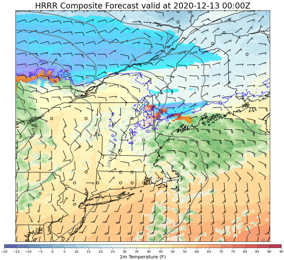
Between noon and 5 PM, the timeframe covered by this forecast loop, most of the area will change from rain to snow in response to the dynamic cooling process I described above. The exception will be portions of the Midcoast east of Bath and south of Route 1 where the warm air ahead of the storm will be a bit more resilient.
Because this storm will be intensifying so rapidly, the bands of snow that will impact the area this afternoon/evening will be extremely intense. Snowfall rates of 1-3″ per hour are likely and thundersnow is a decent possibility closer to the coast. As the storm center approaches, winds will be picking up out of the north. By sunset, most of the area will be seeing sustained winds of 20-30 mph with gusts to 30-40 mph. Spots along the coast will see the strongest winds, possibly gusting up to 50 mph.
With that in mind, this looks to be a fairly widespread power outage event due to the combination of copious heavy wet snow and strong winds. Take some time this morning to prepare for power outages that might last a little while as crews will have quite a bit of work ahead of them over the next few days.
Snow will continue falling overnight as winds start to flip around to the northwest and substantially colder air rushes into the region. During the early overnight hours, parts of the Midcoast might see some sleet mix in before changing (back) over to snow even south of route 1.
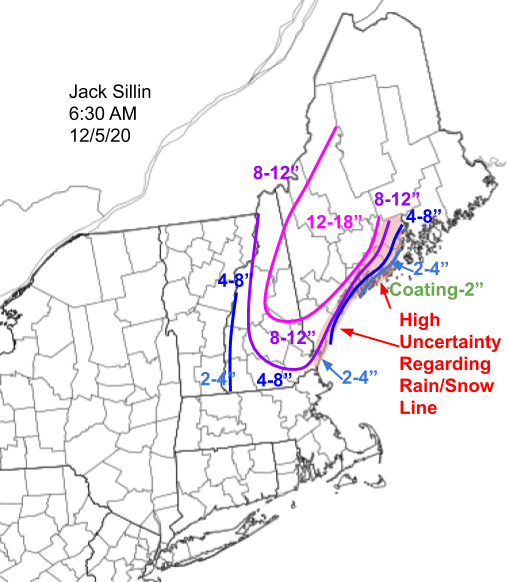
Here’s an updated look at the snowfall forecast, which really hasn’t changed a whole lot since yesterday.
I bumped totals up a bit along the coast south of Portland where mixing with rain looks to be confined to the front end of the storm. The Midcoast is still the trickiest part of the forecast, but if you’re south of Route 1, generally expect a couple inches on the very back end of the system. If you’re north of Route 1, totals will approach the foot mark pretty quickly, especially north of Bath/Brunswick.
Snow will taper off to flurries by tomorrow morning as the storm moves into the Canadian Maritimes.
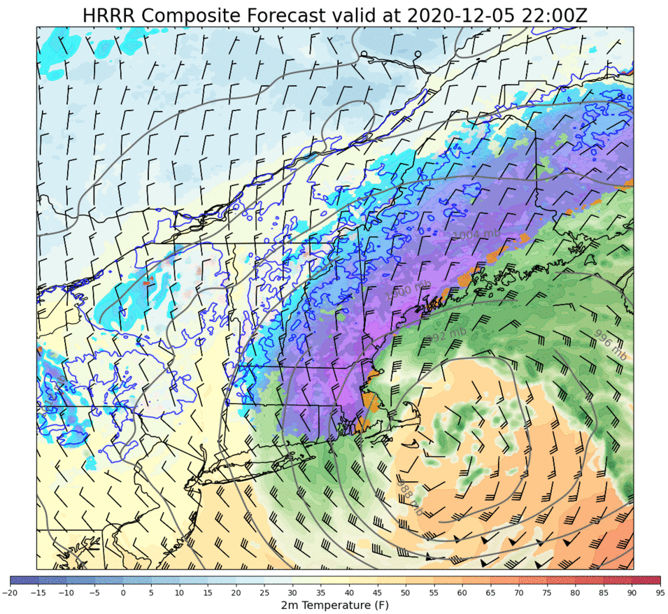
Another storm is on the way for tomorrow and I’m delighted to say it should put on a pretty good show with heavy snow and gusty winds. The leadup to this storm will be a bit unconventional as southwesterly flow around a low pressure system over Quebec brings milder air into the region. Normally we look to see high pressure over Quebec feeding cold air into the region ahead of a potential snowstorm but alas. Maybe next time.
This map shows several different analysis and observation products but most relevant for most of are the temperature observations which are all the little numbers. Note that our area is embedded within the warm sector of a low over Hudson Bay which means temps are generally in the upper 30s to mid 40s. A cold front is noted over the Great Lakes and behind it, temps are much cooler (10s/20s).
Today, we’ll be mostly feeling the warm air moving north ahead of the northern upper-level disturbance on the map above. Any time warm air is trying to root out some pre-existing cold air, we have to look out for clouds and some light precipitation.
That’s exactly what forecast model guidance is expecting across the area today, with the best shot of some light rain/snow up in the mountains. Showers could expand towards the coastline this evening but overall precip will be spotty and light today as high temps rise towards the mid 30s up north and mid 40s along the coast.
By tomorrow, the disturbances mentioned above will join forces off the Virginia Capes and we’ll have ourselves a rapidly intensifying storm headed northeast. The loop below shows a model forecast for energy around 20,000 feet aloft.
For those with a meteorological background, this loop contains a treasure trove of information about the storm’s forecast. But even if it just looks like pretty colors to you, hopefully you’ll find it a satisfying rendition to illustrate the merging of the disturbance over the Great Lakes with the disturbance over Missouri into a big storm approaching Cape Cod.
Precipitation will begin moving into the area tomorrow morning in the form of a cold rain. However, as the storm intensifies, it will draw cold air down into the region from Quebec. Additionally, we’ll get to enjoy a process known as “dynamic cooling” where furious upward motion and heavy precipitation northwest of the storm’s center drives a chain reaction of thermodynamic processes from the expansion of air parcels to the transfer of latent heat that allows the storm to manufacture its own cold air locally.
Thus by tomorrow afternoon, almost everyone except for the immediate coast south of Portland (east of the Turnpike) and Midcoast (south of Rt 1 especially) will be enjoying heavy snow with temps right around or just above freezing.
via Tropical Tidbits
During the afternoon and evening, a process known as “frontogenesis” or the creation of a new frontal boundary will be helping to support very heavy precipitation. Where snow is falling, it will accumulate at a rate of 1-2″ per hour despite the relatively meager surface temperatures. Believe it or not, you can get rapid snowfall accumulations with surface temps above freezing! We last experienced this phenomenon on April 9th of this year when over a foot of snow fell across much of central Maine despite temps through most of the event sitting around 32-34F.
Because our storm will be driven by two disturbances joining forces, it will undergo bombogenesis which means its central pressure will drop by more than 24mb in 24 hours. What’s the upshot of that?
Not only will the snow fall heavily at times, but we’ll also have to deal with gusty winds. Winds will be sustained around 20-30 mph across the region tomorrow afternoon with gusts higher than that, especially along the midcoast. Normally this is a little below my threshold for talking power outages, but once you paste the trees and power infrastructure with heavy wet snow, it doesn’t take all that much wind to bring stuff to the ground. With that in mind, everyone should be ready for power outages tomorrow night that might drag on for a little while.
So how much snow do I expect? Here’s a look.
It’s always tough to tell where exactly the rain/snow line sets up and obviously that’s a pretty important part of the forecast. Right now, I’d draw it from the York County coast to Brunswick-Bath-Damariscotta-Belfast. Northwest of that line, snow totals will quickly ramp up to 8-12″ (or maybe a little more). But you won’t have to go very far southeast of that line to end up with bare ground. The big winner with this one will be the Sugarloaf area which could end up with as much as 18″. The snow up there won’t be the same cement that the coast will see but it won’t exactly be blower pow either. Honestly though, that’s good news. We want to build a dense base now so we’re not scraping rocks when the fluffier stuff hopefully shows up in January and February.
I’ll have an updated look at the storm forecast tomorrow morning.