
Hello everyone!
While we’re not even 24 hours removed from our most recent winter storm, we’re less than 24 hours away from kicking off the next one. Today will feature mostly quiet weather ahead of that next storm.
Satellite imagery this morning shows a couple breaks of clear skies especially southeast of the mountains in Maine. Whatever glimpse you get of the sun this morning will be short-lived as clouds push into the region from the southwest ahead of the next storm. Those clouds will help keep temps in check today despite relatively warm air aloft. Highs look to range from the upper 20s north to the mid 30s along the NH Seacoast.

By this evening, light snow will break out in NH and adjacent parts of southwestern ME as shown by the darker blue shading on this forecast map valid at 8 PM.
The big question then becomes: just how much snow is this storm going to drop? This question has been frustratingly hard to answer over the past couple days.
The central problem is that unlike most of our storms here in New England, this one appears likely to hit the brakes just east of Cape Cod and basically sit still for a couple days. Where exactly the storm decides to camp out will determine whether parts of our area get a couple inches or a couple feet of snow.

This loop shows that “stalling” process with bands of heavy precipitation lurking just northwest of the low’s center. Right now, most forecast model guidance suggests that these heavier bands will stay just offshore. This would keep snowfall totals fairly modest especially in the foothills/mountains. However, a wobble 50-75miles northwest would mean that instead of lingering over the ocean, these heavy bands could linger onshore and drop substantial totals.
Given all that uncertainty, it’s tempting to kick the can down the road a little more on a snowmap but since flakes start to fly in less than 12 hours now, it’s time to offer a first guess.
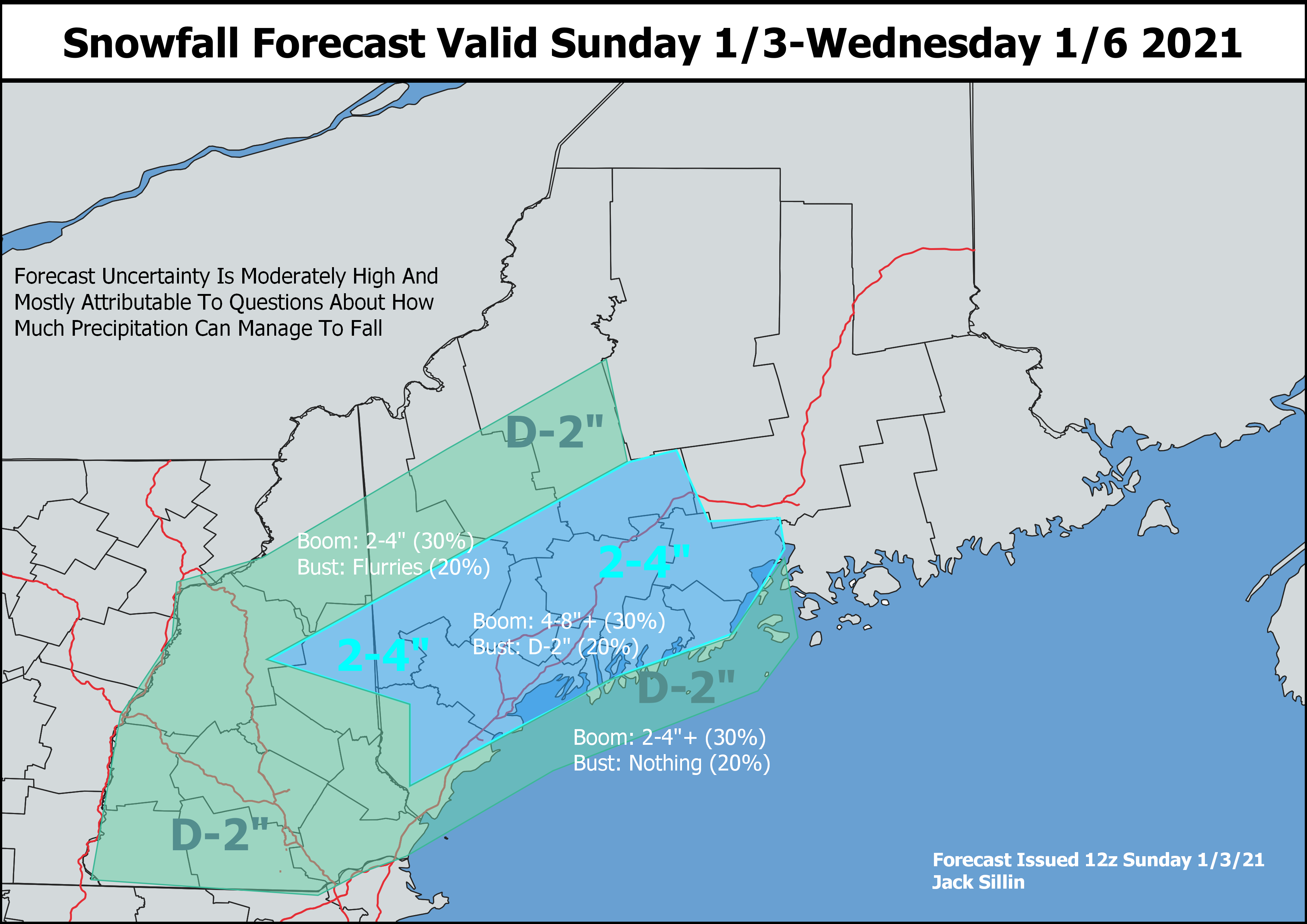
The highest totals I think will be found in interior parts of the Midcoast where I bet we’ll see plenty of 4,5, and 6″ reports. Confidence wasn’t quite high enough to include a 4-8″ contour but I was pretty tempted between Augusta/Waterville, and Camden/Belfast. Otherwise, there are some solid hints of a band setting up from the Whites through the ME foothills so I tried to reflect that in the 2-4″ contour. Surface temps will be right around freezing for most of this event which means that accumulation will be tough and heavily dependent on precipitation intensity right at the shoreline.
I’ll be following along with today’s forecast data closely and if any substantial changes to the forecast are needed, I’ll do another update this evening. Otherwise, let the light flakes fly this evening and revisit in the morning once we move into the stall/pivot phase of the system.
-Jack
