Hello everyone!
After a long stretch of extreme tranquility here in northern New England, Mother Nature is ready to rumble once again. A powerful Great Plains blizzard will tap into moisture from the Gulf of Mexico as it heads east tomorrow, setting up a nice heavy precipitation event for our area.
Before we get to enjoy that storm, quiet weather will be the rule again today. Low clouds are noted on satellite imagery across much of the mountains and foothills while some sunnier breaks are seen closer to the coast. As the day goes on, mid/high clouds will advance from the southwest and low clouds will move in off the ocean so the whole region should end up overcast by sunset (except perhaps for far northeastern areas near Waterville). High temps will range from the low 30s up in the mountains to the low/mid 40s in southern NH.
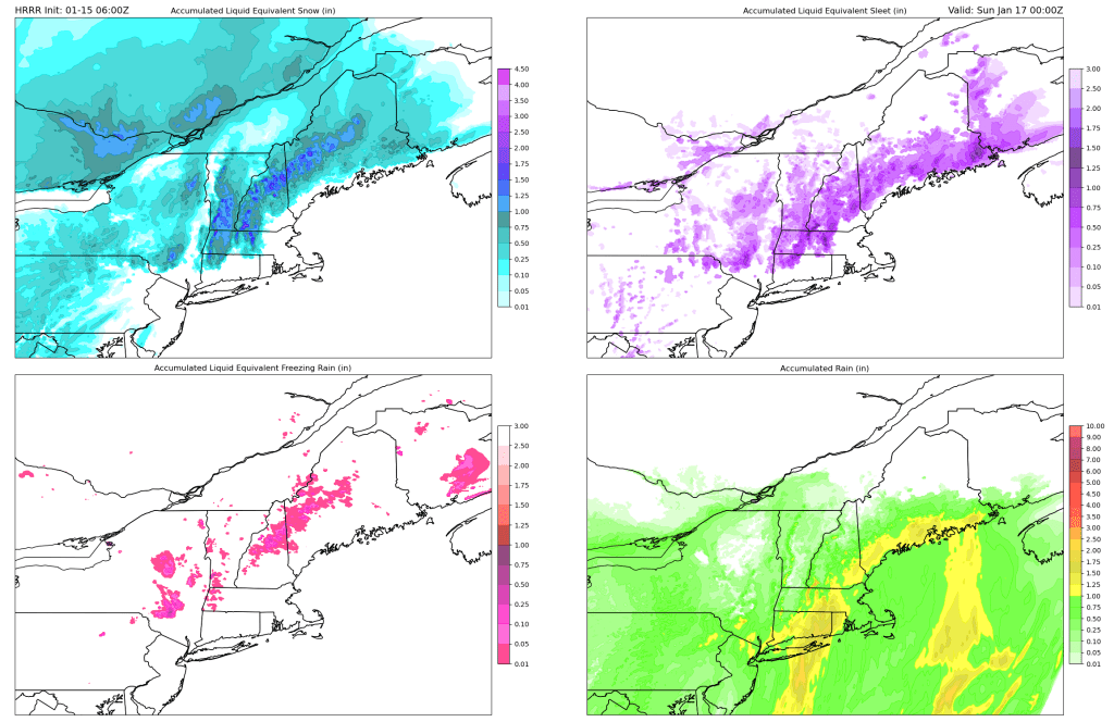
Precipitation will arrive from southwest to northeast tomorrow morning. Initially, precip will likely fall as freezing rain up north and a mix of rain/snow/sleet closer to the coast. As the storm gets closer, the mountains will change over to snow and the coast will change over to rain with the foothills becoming the battleground for rain/snow/sleet. By the time the heaviest precip starts moving out, rain should be the dominant precip type outside of the mountains with snow hanging on in the higher terrain.

This map gives a pretty good idea of where to expect snow, sleet, ice, and rain. Focus less on the numbers and more on the general footprint of each precipitation type. The highest snowfall totals will be on the higher summits with more modest accumulations in the valleys and northwestern foothills. Most of the foothills will see sleet, which could mix in over the mountains too. Any ice accretion should be fairly light and confined to the mountains during the onset of the event. Down along the coast, this one is all rain.
What do accumulations look like? I didn’t have time to pull together a map myself this morning so I’ll pass along what our friends up at the NWS in Gray have put together.

The jackpot 12″+ totals will be up above 4,000 feet in the Whites and near the summit of Sugarloaf. Most of the rest of the mountains above say 2,500 feet will get 8-12″ with the valleys picking up around 3-6″. Amounts will taper off quickly as you head down into the foothills, though the mix of snow, sleet, and rain will produce icy roads.
Behind the storm on Sunday, snow will continue in the mountains while the rest of us dry out on gusty west-northwesterly winds.
-Jack

I appreciate your great skill and effort in providing these forecasts Jack and for that, it’s 👍. However, for the storm that’s being forecasted it’s 👎. I am so ready for spring. If these type winters continue until I retire in two years, I am so outta here. The winters were fantastic for about 10 years after I first moved here to the foothills in the late 90s. Outside an occasional descent one here and there, they’ve gotten overall progressively worse since then.
I’m not sure “enjoy” is the right description of cold rain.