
Hello everyone!
We have another storm on the horizon as low pressure over the Ohio Valley prepares to pass its energy off to a new storm developing off the coast of North Carolina.
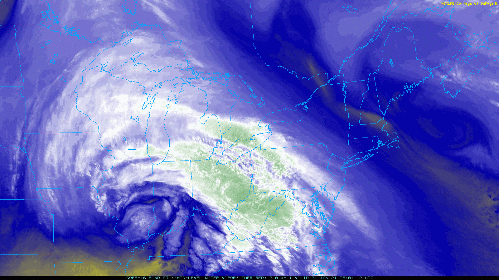
We can see the original swirl over the Ohio Valley clearly on Water Vapor satellite imagery this morning. The new swirl offshore will appear sometime tomorrow morning.
Ahead of the swirl and the cloud cover it’s producing, we have clear and calm conditions in place across the region this morning. That means that nighttime cooling has been able to do an exceptionally good job turning down the thermostat. Temps right now range from around 20 below up north to around zero near the coast. With clear skies and light winds, this bitter cold shouldn’t last long but be sure to bundle up if you’re headed outside in the next few hours. High temps this afternoon will range from the upper 10s up north to the mid 20s in the south.
Skies should remain mostly sunny until the mid/late afternoon when mid/high clouds will start filtering in from the southwest.
The storm itself will take its sweet time getting up to our latitude. The first phase of the system, associated with the swirl over the Ohio Valley, is bringing snow to much of the Mid Atlantic this morning. The northeastward advance of the snow will pause for most of today as the first swirl passes its energy to a new swirl offshore.
By tomorrow morning, snow will be moving north once again as the coastal storm gets going.
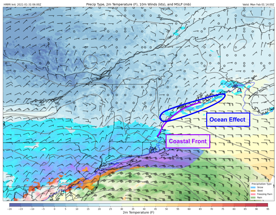
Out ahead of the main precipitation shield, cold air moving over the relatively-warmer Gulf of Maine will support some ocean effect snow along the immediate coast. With winds mostly from the east, the best shot at a dusting to an inch will be from Casco Bay on south. This snow shouldn’t be heavy nor will it pile up very much, but it will make roads slick in spots so watch out if you’re headed somewhere south of Brunswick and east of the Turnpike starting midmorning tomorrow.
The main push of snow will arrive from south to north during the afternoon and evening hours tomorrow. Snow will become heavy at times especially in the south and especially after dark.
The atmospheric setup tomorrow night is best depicted with some information about what’s happening around 10,000 feet above our heads at what meteorologists call the “700mb level”.

At this altitude, the storm will be centered over New Jersey tomorrow night with a warm front extending into southern New England and out into the Gulf of Maine. That warm front will be strengthening over time, a process known as “frontogenesis”. Why is that important? Where frontogenesis goes, so goes a band of (very) heavy snow. Around midnight tomorrow, that frontogenesis band will be pushing up through southern Maine and central New Hampshire. This is the window to watch for 1-3″ per hour snowfall rates.
After the big heavy snow band driven by frontogenesis, all eyes will turn to the location of the actual warm front at 700mb. Northwest of this boundary, deep moisture and strong lift will continue to produce moderate-heavy snow, even if it isn’t as intense as the big frontogenesis band. Southeast of this boundary, dry air will be moving in aloft and will cut down significantly on precipitation rates and snowfall ratios. This feature may even introduce some mixed precipitation over the Midcoast.
Most guidance this morning indicates that the dry slot will push through most of the area by Tuesday afternoon, leaving only the mountains under the influence of the initial frontogenesis band.

During this time, expect generally light snow mixed with sleet and freezing rain at times east of I-95/I-295. Around this time, all eyes will turn to the third phase of the system which will be rapidly developing southeast of Cape Cod. On the map above, we can see this third low has its own pocket of moisture and another batch of extremely strong frontogenesis. This means that wherever it goes, it will bring a second round of heavy snow. The question of course is its track. Some guidance indicates this low might move northwest towards Rockland, in which case most of western Maine would get another round of heavy snow. Another possibility is that it heads more north towards Machias and brings the heavy snow to Bangor and the rest of northern/eastern Maine.
Right now, I’m leaning more towards the latter scenario mostly because of how unusual it would be to see a low move from southeast to northwest like that. But I’ll be keeping a close eye on trends over the next day or so in case that changes.
So how much snow are we talking?
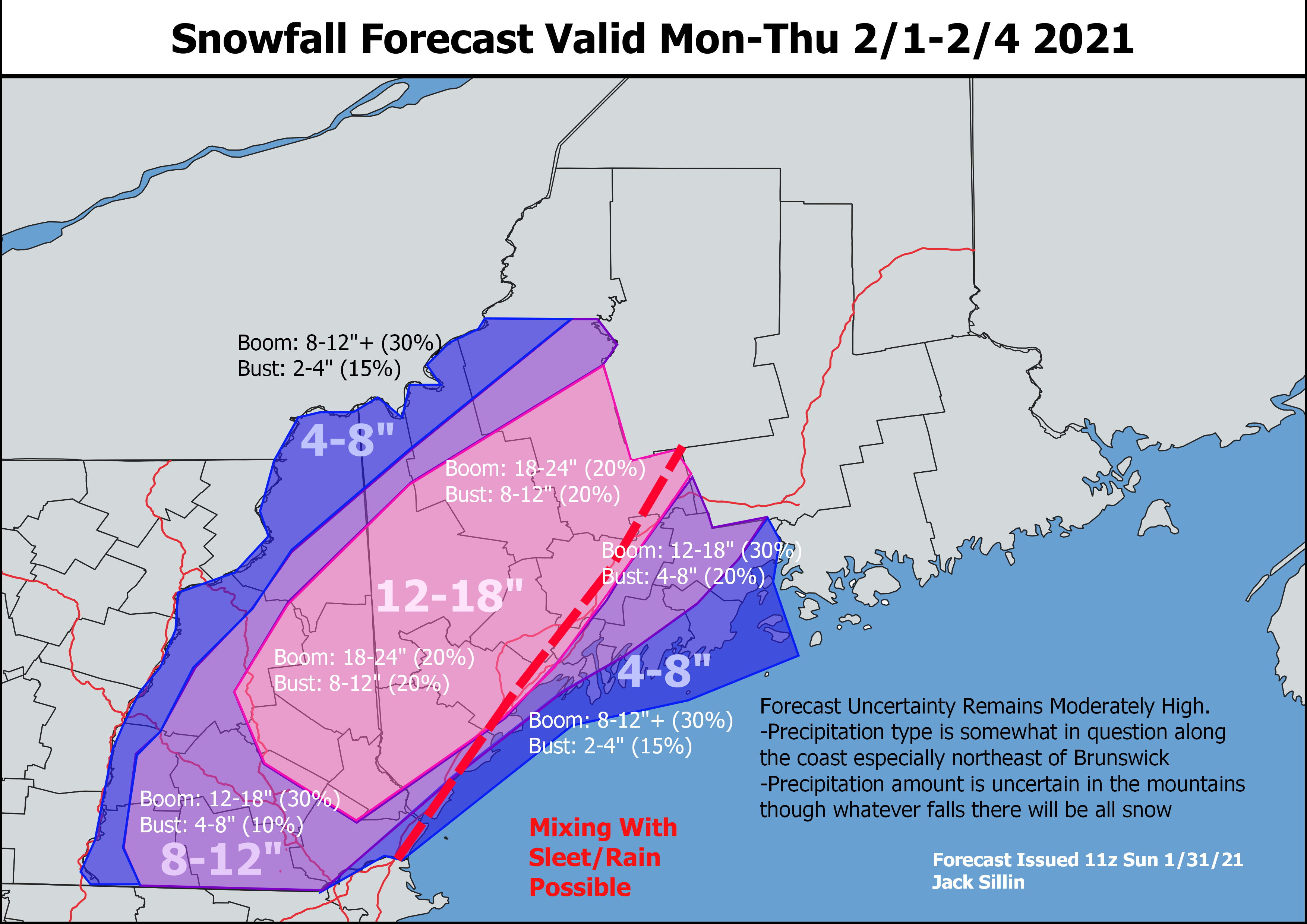
Here’s my best guess at the moment. Most of the region is likely to see between 8 and 16″ of snow, with higher amounts possible in the pink shaded area and lower amounts expected along the Midcoast and in far western/northwestern areas.
At the moment, my biggest question is regarding the areal extent of 12″+ reports. I have a fairly wide swath of the area in the 12-18″ range but it wouldn’t take much to end up with a lot of 10″ reports in that area instead of a lot of 14″ reports. Farther east, I’m a bit bearish on snow in the Midcoast due to the challenges associated with dry slotting and the shorter duration of heavier snow rates tomorrow night. That said, if the third system ends up tracking farther northwest, I may have to bump up totals especially north of Route 1.
I’ll have another update on the storm tomorrow morning or perhaps this evening if warranted.
-Jack

👍
Great maps. Thanks!