
Hello everyone!
Today will feature the arrival of a seasonably strong nor’easter bringing heavy snow, strong winds, and the possibility of some mixed precipitation.
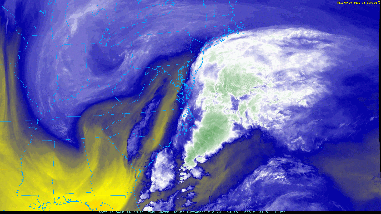
Water Vapor satellite imagery leads the way as always this morning. The first swirl we were watching over the past few days is fizzling out over Ohio while the second is moving quickly east near the TN/NC border. As that second swirl meets up with the plume of deep moisture off the East Coast noted in green, the second phase of our storm will begin in earnest.
This second phase of the storm’s evolution will be part one here in Maine and New Hampshire (we missed out entirely on phase one yesterday over the Mid Atlantic).
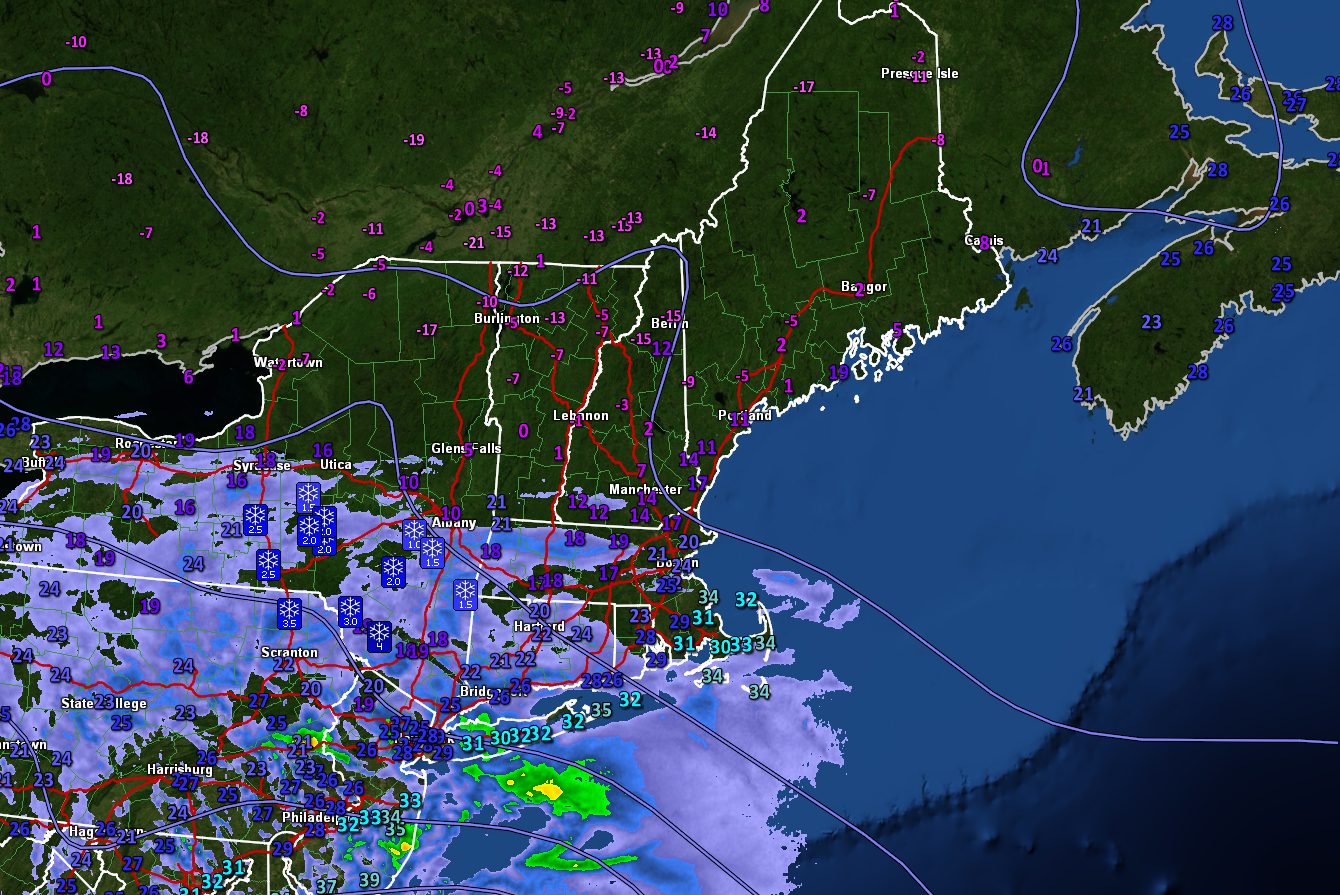
Current observations as of 6 AM show seasonably cold temperatures across the region to start the day while snow is advancing slowly from the south.

Cold and calm will be the name of the game for the first part of the day as the storm gets its act together south of our area. Morning breaks of sun will be most common in northern and western parts of the area as clouds advance from the south and east. By late morning, ocean effect snow showers will be developing just offshore and will start to impact portions of the coast south of Portland. A dusting to 1″ is possible from ocean effect before the main storm begins after noon.

By 5PM, the time at which this map is valid, moderate to heavy snow will be underway across southern NH and southwestern ME while light snow starts to break out over central and northern areas. Because we’ve been enjoying such cold temps for the past few days, even the first few flakes will stick to the roads so conditions will go downhill not long after snow begins falling. Take it slow on the evening commute today if that’s still a thing for you, and use the storm as an excuse to duck out a few minutes early if you can.

The heart of the storm will arrive later this evening as the second swirl peaks in intensity south of Long Island. Heavy snow bands will pivot north through the region during this time, dropping snow at rates of 1-3″ per hour. Meanwhile, increasing northeasterly winds will lead to blowing and drifting of snow especially inland where temps will be cooler and the snow fluffier.
With gusty winds and heavy snow, will this storm qualify as a blizzard?
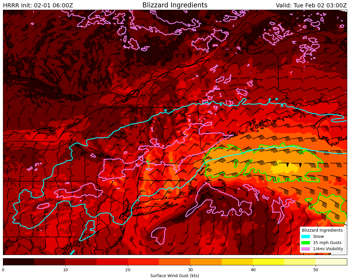
The answer comes down to whether three criteria can be met at any given place for three consecutive hours: visibility at or below 1/4mi, winds sustained or frequently gusting above 35mph, and heavy falling and/or blowing snow. The map above outlines where each of the three atmospheric conditions will be met at 10 this evening. If you’re in all three circles, congrats! You’re experiencing blizzard conditions!
Most of the region is in the blue circle meaning that snow is falling. Southern areas are inside the pink circle which means that visibility has been reduced to 1/4mi or less. But only some hilltops in southern NH and parts of the York County/NH coast are in the green circle with wind gusts over 35mph. So while travel conditions will be rather dangerous, we appear unlikely to meet the rigorous criteria to deem this officially a blizzard. It sure will feel like one though!

By tomorrow morning, the second swirl will begin weakening which means precip in our area will too. As warmer and drier air moves in around 10,000 feet, precipitation types will start changing too. Rain may mix in along the Midcoast peninsulas and east of the Turnpike south of Portland. Sleet will be a little more widespread especially east of the Turnpike north of Portland. Freezing drizzle will be more common as you move farther west as temperatures remain cold, but snowflake production gets interrupted. This will mark the end of the first round of substantial accumulations in Maine and New Hampshire.
At this point, about 6-10″ of snow should be on the ground with the most in southern NH/SW ME and the least up in the mountains (where it will still be snowing). Lower totals are possible along the Midcoast.
After a break in the action Tuesday morning, a third swirl will form southeast of Cape Cod and take an unusual track to the north-northwest to bring another round of steady/heavy precipitation.

This round will begin from southeast to northwest around noon on Tuesday. Initially, precipitation will fall as rain along the Midcoast peninsulas, sleet in the I-95 corridor, and snow in the mountains. As the third swirl undergoes rapid intensification over the Gulf of Maine, colder air will be drawn south and everyone will change back over to snow.
This second round will drop another 4-8″ in the mountains with lower totals closer to the coast due to mixing.

Here’s an updated look at storm total accumulations combined between the two rounds. Only minor tweaks have been made since yesterday including an expansion of the 12-18″ and 8-12″ zones in southwestern Maine and southeastern NH due to better confidence in additional accumulations from the third swirl. I trimmed back the 12″+ zone along the I-95 corridor north of Portland due to issues with mixing midday tomorrow. One could spend many many hours tweaking the lines here, but this is as good a guess as any and unless something really big changes, will be my final shot at a snowmap for this storm.
Snow will taper off Tuesday night with another round of light/moderate snow possible Wednesday, especially in the mountains.
-Jack

Great analysis! Any chance you have forecast map for snow totals for Downeast/Bar Harbor region? Thanks!!!
Thanks Kristen! I only draw maps for Western ME (that takes long enough as it is haha) but I bet Bar Harbor gets 4-8” or so.
Oh, ok! Well, love your forecasts! Thanks!