I’m a third-year atmospheric science student at Cornell University who has been blogging about the weather since 2011. While I’m not officially a meteorologist, I have accumulated a bit of experience forecasting both local weather (in western Maine and New Hampshire) as well as national/international weather during my time writing for weather.us and weathermodels.com. I also have experience programming in Python, teaching concepts in weather forecasting, and communicating forecast information to general audiences.
We’re stuck in a stagnant pattern today with lots of low-level moisture and very little left or moisture higher up in the atmosphere. That means drizzle will be the favored precipitation type, especially southeast of the mountains. A quick peek at current temps shows all but the immediate coast south of Portland, the Midcoast peninsulas, and the NH Seacoast below freezing. That means drizzle will be freezing for most this morning, leading to slick travel. As temps warm slowly throughout the day, most of the coastal plain should end up above freezing though slick conditions will continue inland. Some snow will fall up in the mountains, but accumulations shouldn’t exceed an inch unless you really find the highest terrain.
Yesterday’s storm system will be slow to depart today, leaving us with seasonable temps and subtle hints of unsettled weather. Northwest winds will pick up especially this afternoon, but there’s too much low-level moisture left over for a clean downslope. So clouds and snow showers will linger especially up in Maine while breaks of sun attempt to develop in southern NH. Temps will range from the mid 20s in the far north to the mid 30s along the southern coast.
It seems Maine has made it onto Santa’s nice list this year as we’re just a couple hours away from snowfall breaking out across the state as weak low pressure meanders through New York. Unfortunately, Southern New Hampshire is on the naughty list and will get a hearty coating of freezing rain to go with the coal in their stockings.
Snow and freezing rain are already falling across much of NH and precip will begin in western Maine over the next couple hours. Snow will be steadiest midmorning through early afternoon before tapering off from northwest to southeast. Snowfall totals will be highest in the White Mountains (3-6″), tapering off to the south due to mixing (1-3″ snow/sleet and 0.25-0.5″ ice) and to the north/northeast due to a lack of moisture/lift (1-3″ of lighter snow). Parts of NH south of 101 that could make a run at 0.5″ ice will need to watch out for power outage issues later today.
Precip will taper off to snow showers this afternoon before a secondary disturbance will try to revive a period of light/moderate snow for southern Maine overnight. An additional 1-2″ is possible especially near Casco Bay depending on the strength of this band.
Temps will range from the mid 20s up north to the mid 30s right along the NH Seacoast.
Quiet weather will generally be the rule today as a powerful blocking ridge punts a weakening clipper out to sea well south of our area. Southern spots are seeing some cloud cover from this system and a snowflake or two can’t be ruled out over southern NH but otherwise it’ll be dry today. Skies will remain clear in northern and central areas, and will clear out across the south this afternoon. Temps will top out in the low 20s up north and mid/upper 20s in the south.
We do have a storm coming in tomorrow but it’s a tricky one to figure out from a forecast perspective. I’ll put out a more thorough update later this afternoon/evening once I’ve had a glance at the next forecast cycle.
Today will feature cooler temps and a brisk NW wind as Canadian air reclaims its wintertime territory over Northern New England. Look for highs ranging from the mid 10s up north to the mid 20s in the south with partly to mostly sunny skies. A few clouds will advance from the southwest this afternoon ahead of our next weak storm system which will put some flakes in the air tomorrow especially south of Portland.
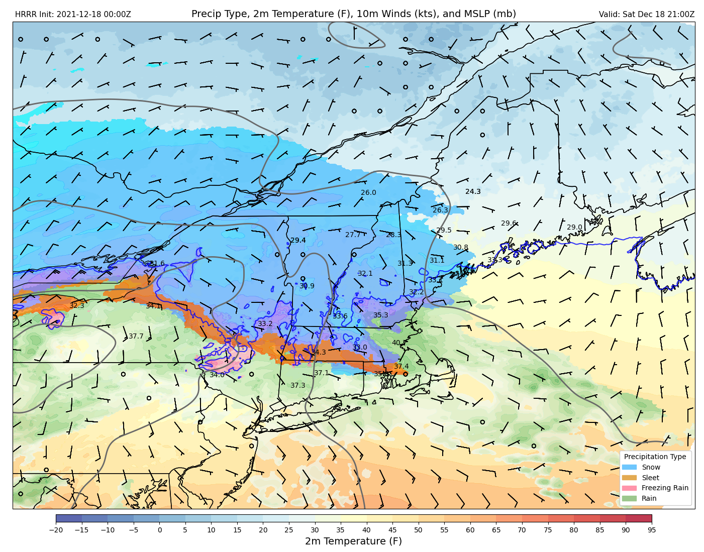
Today will feature a messy medley of wintry precipitation as an offshore storm teams up with a cold front approaching from Quebec to provide moisture and lift across most of our area. Precipitation is ongoing this morning with freezing rain being the dominant precipitation type near the coast while the foothills see a mix of snow, sleet, and freezing rain, and the mountains enjoy pure snow. If you’re down in Boothbay Harbor, at the end of Pemaquid Point, or near Kittery, you’re just warm enough to get plain old rain. The net result of this wintry mix will be slick travel across much of the area (especially on untreated roads).
Anytime we get freezing rain, most people immediately get concerned about power outages as the ice can easily weigh down trees and lines. It takes about 1/3″ of ice to get really concerned about power outages and I think areas meeting that criteria will be few and far between today. However, a few unlucky folks may end up in the dark this afternoon especially along I-95 north of Brunswick.
Precipitation will clear out from west to east during the early afternoon with sunshine returning quickly to the foothills and coastal plain. Westerly breezes and the mixing action of the cold front will push high temps into the upper 30s for most of the area after precip shuts off, though the mountains should stay below freezing.
Satellite imagery and a peek out the window this morning shows a mix of sun and clouds in place across most of the area with the brightest skies along the coast and the thickest clouds upwind of the mountains. Westerly breezes, milder air aloft, and partial sunshine will push temps a bit higher today, ranging from the mid 20s up north to the mid 30s along the coast. Clouds may start to increase this afternoon ahead of our next storm slated to arrive tomorrow.
That storm is worth a mention in this morning’s update because it will feature a mixed bag of precipitation. Snow is most likely up in the mountains and especially north of Augusta while the I-95 corridor will deal with freezing rain. Ice will accumulate especially from Portland to Augusta, but amounts will likely hold in the 0.15-0.3″ range, just shy of when we start really worrying about power outages. That said, I wouldn’t be surprised to see a few unlucky folks in the dark tomorrow, so plan accordingly. Travel will also be extremely slick with freezing rain and temps in the mid to upper 20s. More details tomorrow.
Today is starting off clear, calm, and cold as high pressure crests overhead. Temps will rebound from the single digits above/below zero this morning to around 20 up in the mountains and 30 along the coast. Skies will remain bright for most of the day, at least south of Route 2, but clouds will slowly increase this afternoon as a weak cold front approaches from Quebec. That front will arrive after dark with light snow in the mountains and no discernable impact along the coast.
Last night’s storm is headed for the exits this morning, and most of the steady/accumulating snow is done already. We just have a few light snow showers remaining this morning in the eastern foothills and coastal plain. These flurries will dry up by around noon with dry northwest breezes helping to bring sunshine to areas downwind of the mountains by the early afternoon. Up in the mountains, upsloping will continue to lock in the clouds and keep flurries going into the afternoon. High temps will range from the mid 20s up in the mountains to the mid 30s in SE NH.
It won’t be a blockbuster blizzard, but the first real winter storm of the season is arriving today as low pressure tracks along I-90 from Buffalo to Boston. Precipitation will arrive in southwestern NH early this afternoon before spreading northeast into Maine closer to sunset. While temps will start out around or above freezing in most places, evaporational cooling should start just about everyone off with snow as a precip type except perhaps for the NH Seacoast.
Here’s a forecast map valid at 5 PM showing snow falling across much of the area with just southern NH experiencing some rain as winds are a bit more onshore.
The steadiest and heaviest snow will fall early in the overnight period as the storm passes just to our south before beginning to taper off tomorrow morning.
This forecast map valid at 11 PM shows moderate to heavy snow falling across much of the area while a coastal front sets up south of Portland, introducing some sleet, ice, and rain.
As the sun comes up tomorrow, light snow will linger across most of the area and mixed precipitation over SE NH/coastal York County will change back over to snow. Not much additional accumulation is expected, but roads may remain slick until midday.
So how much snow are we talking?
Here’s a quick look at what I’d expect from this event in our area. The jackpot will, as usual, be the mountains of western ME and NH where colder air and better lift will set up more favorable snow to liquid ratios. Most of the ski areas should get a solid 8-12″ though if it were me I’d pick Sunday River over Sugarloaf for this storm.
For the rest of us, it’s looking like a general 4-8″ with lower totals in southern NH where sleet/ice will mix in and especially along the immediate coast where rain will enter the picture.
All in all this won’t be a big storm by our standards, but it will provide some much-welcomed snowcover as we get closer to Christmas.