All posts by Jack Sillin

I’m a third-year atmospheric science student at Cornell University who has been blogging about the weather since 2011. While I’m not officially a meteorologist, I have accumulated a bit of experience forecasting both local weather (in western Maine and New Hampshire) as well as national/international weather during my time writing for weather.us and weathermodels.com. I also have experience programming in Python, teaching concepts in weather forecasting, and communicating forecast information to general audiences.

Prolonged Nor’easter to bring significant impacts this week

Hello everyone!

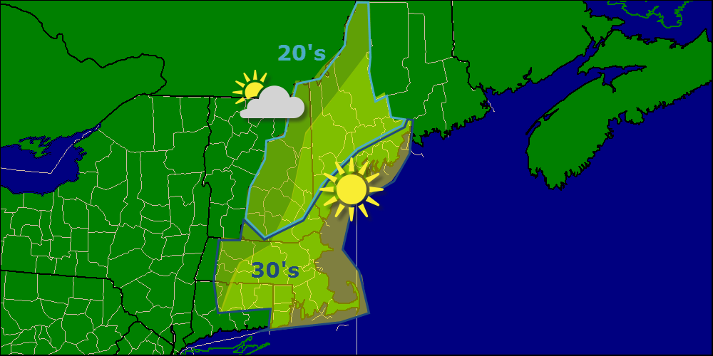
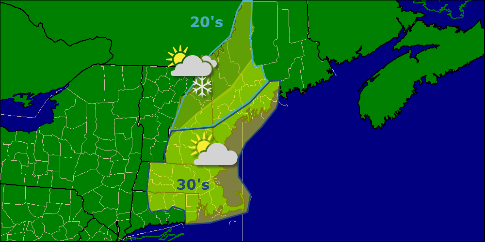
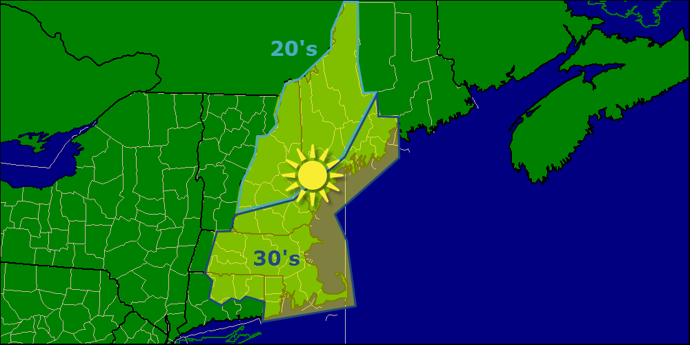
While tomorrow will feature frigid conditions and mainly clear skies in the morning with clouds building in as the day goes on. Frigid temps can be expected tomorrow morning with lows ranging from 10 below to 10 above. I’ll have more details tomorrow morning.

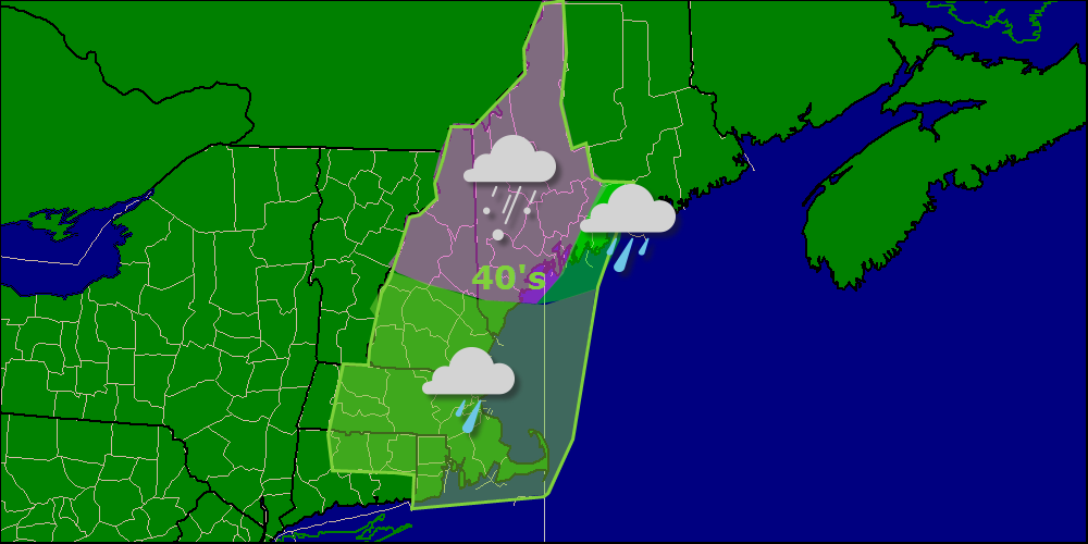
While this update will be a little less detailed than I had hoped, I will still try my best to give you good insight into what will happen tomorrow into Wednesday. Here is an impact-by-impact breakdown of what to expect for the first part of the storm.

Rain

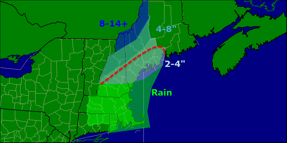
There will be lots and lots of rain with this one, no question about it. Expect amounts in the 2-4″ range for Coastal Maine and New Hampshire as well as most of MA and CT as well as all of RI. This is a pretty straightforward forecast and confidence is moderate-high.

Snow

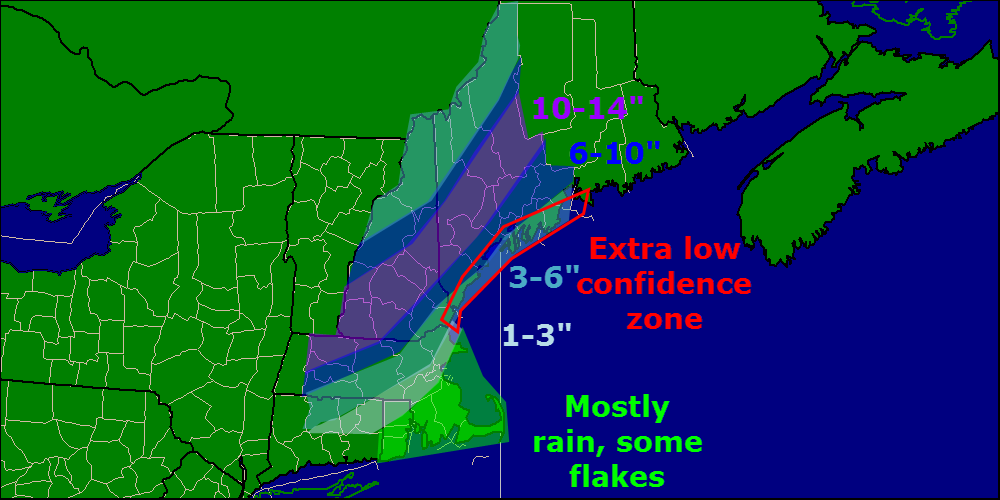
If you missed the uncertainty, you can find it here in the snow section. Everyone sees some snow to start Tuesday with ocean effect and overrunning but as warm air works in from the ocean, as well as from the SW aloft, the coast should see a switch to rain and the foothills should see a switch to sleet or freezing rain. After the bulk of the precip leaves Tuesday night, things get even more uncertain because the exact track of the upper low will determine who gets a bonus round Wednesday into Thursday. The map below shows totals through Wednesday Morning with the first round.

snow map 12-7

South of the red line, expect any snow that falls plus any that is on the ground to be long gone by Wednesday  morning.

Wind

Wind will be a big concern here as well due to the developing low and the sprawling high to the north creating a large pressure gradient. Expect sustained winds in the 20-40mph range with gusts over 50 mph possible. There is the possibility of gusts much higher than that but for now 50mph is a safe bet for coastal areas. High winds plus a saturated ground at the coast and heavy snow inland could lead to possibly widespread power outages.

Coastal Flooding

Any time you get a prolonged period of onshore winds, you have to worry about coastal flooding and concerns for coastal flooding are very real along any E/SE facing areas. With a solid day and possibly more of strong onshore winds, expect some splashover and beach erosion.

I’ll have more details on everything tomorrow as the puzzle continues to come together.

-Jack

Freezing rain continues to impact the area this morning

Hello everyone!

Quick update this morning on the evolution of our current storm as well as a sneak peek at the Tuesday storm.

Current temps/winds indicate the coastal front that is determining precip type this morning is not moving much. In fact, south of Brunswick, it is moving east, away from the coast. Most of York county is at or above freezing so expect mainly rain from here on out for that region. Cumberland county is still below freezing except for Cape Elizabeth. With the current evolution of the coastal front, don’t expect this situation to change much today. Midcoast areas East and South of Bath and Whitefield are all rain and will stay that way with temps in the upper 30’s to low 40’s. Inland areas are 100% below freezing and look to stay that way even after precip wraps up.

By the time precip wraps up this afternoon, expect widespread ice amounts of .1-.3″ with the highest amounts showing up across Cumberland and Androscoggin counties. 3-6″ of all snow is expected for the mountains while .25″ of rain can be expected at the midcoast. With all the ice, power outages will be a concern but a minimal one since winds will be minimal.

Looking ahead to our next storm, it appears to be a long and strong one arriving Monday afternoon and possibly sticking around until Thursday. While there are lots of details that still have to be sorted out, I expect significant impacts of some sort for Tuesday especially.

Currently, mostly rain for the coast looks like a good bet but once you get into the mountains on the other side of the upper low, significant snows are possible. Any shift NW would send the snow line into Canada while any shift SE would bring the coast into play for frozen precip.

Wind looks to be the given for almost any scenario as the storm looks to be strong enough to generate a long period of high winds. Depending on the track, these could be out of the NE with snow and thus create power outage concerns or it could be out of the SE with rain, however such an onshore flow would create coastal flooding concerns. Still lots of details to be worked out and I will have a full, map intensive update tomorrow afternoon.

-Jack

Clouds increase this afternoon ahead of next storm

Hello everyone!

Today will feature more cold temps and mainly clear skies with highs only rising into the 20’s and 30’s, much like yesterday, but thankfully sans wind. Some clouds may start to work their way into the region later this afternoon as our next weather maker arrives from the SW.

today 12-5

Our next storm system arrives tomorrow and will be a lot like the one we saw Wednesday. The main difference being that all indications are there will be a weak coastal front with onshore flow to the east and a cold northerly flow to the west. Where this coastal front sets up will be the rain/freezing precip line for this event. Most will see at least some freezing rain although the mountains again look like mostly snow.

-Jack

Cold and Clear Today

Hello everyone!

Today will feature the latest dip in the temperature rollercoaster with NW winds bringing in cooler air. Expect highs to be in the 20’s and 30’s but a stiff NW breeze blowing at 10-20mph will make things feel just a tad cooler then they actually are. Sunny skies will dominate the area with the exception of the mountains where upsloping will provide clouds and a few flurries as well.

today 12-4

-Jack

Freezing rain makes for a very slippery commute this morning

Hello everyone!

Today will feature a slippy sloppy start with freezing rain and sleet falling on top of a few inches of fresh snow. Radar and current observations from around the area indicate very slippery travel conditions along with numerous accidents. Many schools are closed or delayed so be sure to check on that before you head out the door. Freezing precip should wrap up by 9 or 10 and warmer air will finally beat out cold air bringing temps up into the 40’s. Cold air will make a return tomorrow after the passage of a cold front tonight.

today 12-3


Our next chance for significant winter weather arrives early next week.

-Jack

Clear and cold today as arctic high builds in

Hello everyone!

Today will feature clear but cold conditions as an arctic high pressure system builds in. Expect mostly sunny skies with the majority of the cloud cover for the area confined to the mountains and SW areas this evening as our next storm approaches. Highs will be in the 20’s north and 30’s south.

today 12-2

Our next storm system moves in tonight and into tomorrow morning bringing a mix of rain, sleet, freezing rain, and of course snow. Expect 2-4″ of snow for the mountains along with .1″ of ice, 1-3″ inland with .1″ of ice and a Dusting-1″ at the coast with a trace of ice. Not all that significant in terms of amounts but nonetheless, the roads tomorrow morning will be bad to say the least. Everyone flips over to rain midday Wednesday as precip wraps up. I may or may not have another post on this tonight depending on how the forecast changes.

-Jack

Mild today as cold front approaches

Hello everyone!

Today will feature mild conditions across the area as temps soar ahead of a cold front. Expect highs in the 50’s along the coast and 40’s inland. The mountains get stuck with 30’s. The front will bring along plenty of pesky low and mid level clouds although I think almost everyone sees sun by sundown, with the possible exception of the immediate coast.

today 12-1

Another update comes tomorrow morning.

-Jack

A look at the week ahead

Hello everyone!

This evening I will take a brief look at the week ahead as our up and down temperature ride continues. Full updates at the normal time make a return tomorrow.

A cold front will cross the region tomorrow morning but deep cold air will lag behind a bit thus leading to a pleasant day overall across the area. Highs will range from 30’s in the mountains to 50’s on the coast.

Deep cold air moves in for Tuesday and brings fair but chilly weather with sunny skies and highs in the 20’s and 30’s for most areas. NW winds could be biting at times so watch out for windchills.

Wednesday brings our next chance for active weather with warm air surging northward once again. With deep cold air in place, expect a period of light snow/sleet/freezing rain/rain across the area Wednesday morning. Highs will range from the 20’s inland to 40’s at the coast.

Thursday is our next cool day with highs tumbling back into the 20’s and 30’s under mostly sunny skies. Tuesday looks to be a good analog day for Thursday and thus windchills could be a factor once again.

Friday continues the quiet but cold streak Thursday started with highs in the 20’s and 30’s under mostly sunny skies. A few clouds may approach the area in the evening as our next potential storm approaches.

Saturday and Sunday are very uncertain at this point. There are indications some sort of precip will impact the area however it is still unclear if this will be rain/snow and even if it will happen at all so stay tuned throughout the week as this becomes more clear.

Another update comes tomorrow morning at the usual time.

-Jack

Looking Back: Comparing the Forecast to Reality

Hello everyone!

Today, while the weather is cold and quiet, I will take some time to look back on how I did with the forecast for our most recent storm. I will also look back on what I did well and where I went wrong and why.

The Forecast:

snow map 11-25v3

I put this map out 48 hours before the event and stuck with it all the way through.

What Actually Fell:

000

According to the NWS, this is what actually fell.

Region By Region:

The mixing along the coast that was forecast panned out well. Most coastal areas fell into the higher range of the 3-6″ forecast with interior Casco Bay seeing higher totals, as forecast. The only area that underperformed at the coast was Rockland where only 2″ fell. The only significant overperformers were in York county where an unexpected 12+” fell.

Overall grade for the coast: B+

Inland areas lined up very well with the forecast with most areas seeing the 10-14″ forecast. There were a few 15-16″ amounts but overall they were very isolated and most areas verified well.

Overall grade for inland areas: A

The mountains were the weakest area this storm with only some areas south of Rangely seeing the forecast 3-6″. There were widespread 6-8 and 8-10″ amounts near Jackman that were not forecast. Despite the fact that the forecast totals were not expected when just referring to the snowfall map, the discussion from Wednesday morning did note the potential for higher amounts in the mountains

“One thing I should note is the potential for higher amounts in the mountains. Models have pushed the strong frontogenesis band I talked about earlier farther north in recent runs and that could raise snow totals for the ski areas.”  From Wednesday Morning’s discussion.

Overall grade for Mountain areas: B

Overall, I think the forecast was pretty good for the area. I have isolated the culprit behind the blown mountain forecast, the strong frontogenesis band that the models did show but I did not have enough confidence in to change the map. The one true area of surprise was in York county where nothing pointed to 12″+ amounts, though those did fall. Very strong banding was likely responsible for those totals although more mesoscale influences like terrain or location of measurement could also have played a part.

Overall grade for the area: A-

I’ll be back later in the day tomorrow with a look at the week ahead. Brief recap of tomorrow’s forecast: Cold and mainly clear, highs 26-34.

-Jack

Inverted trough to bring light snow this morning

Hello everyone!

Odd timing on this update I know but wanted to bring to your attention the presence of an inverted trough that will bring light snow to the area today. It is currently snowing across southern coastal areas and expect that to continue this morning. Accumulations shod be in the 1-3″ range and should end by 10am, earlier SW and later NE.

After the trough departs, expect partly to mostly sunny skies with temps in the 20’s north, 30’s south. Looking ahead, there are no major storm threats in sight. A warmup of sorts looks to be in the cards for early december.

I’ll continue to update daily here but updates may be at odd times. Normal operations resume Monday the 1st.

-Jack