All posts by Jack Sillin

I’m a third-year atmospheric science student at Cornell University who has been blogging about the weather since 2011. While I’m not officially a meteorologist, I have accumulated a bit of experience forecasting both local weather (in western Maine and New Hampshire) as well as national/international weather during my time writing for weather.us and weathermodels.com. I also have experience programming in Python, teaching concepts in weather forecasting, and communicating forecast information to general audiences.

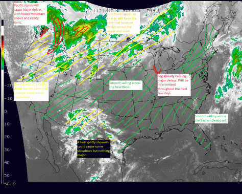
Thanksgiving travel graphic

Happy turkey day everyone!!

-Jack

Weekly graphic

Fairly quiet this week as Thanksgiving travel goes smoothly nation wide. Other than the North Western states where a storm will continue to bring incliment weather well into the week.

-Jack

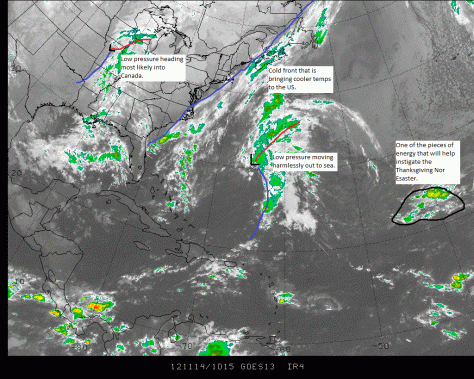
Weekly graphic, Watching Thanksgiving day storm

There is a good potential for a low pressure area to form off the SE US coast. Weather it goes out to sea or moves right near the coast has yet to be determined.

-Jack

Advisory #2 on new Nor’easter

The next storm the east coast will be facing will be a very bad storm for Sandy ravaged areas. This storm will likely bottom out at 990mb slightly weaker then estimates from this morning and a day ago. These estimates suggested pressures of near 980mb. Regardless of pressures, this will be a very bad storm for all ravaged by Sandy. Winds of 35-50mph will ravage areas hit hard by Sandy. Models are trending east with this storm which means that there will be cool air in place in Maine allowing for some snow possibly accumulating to a few inches in mountainous areas. areas closer to the coast may see up to 1″. Accumulations will be tricky to forecast here due to the fact that the ground is warm and it will be a while for the ground to cool off enough to allow for snow to accumulate. 1-2″ of rain will be common from northern NJ to Cape Cod and possibly Seacoast NH.

-Jack

Advisory 1 on new Nor’easter

Less than a week after signing off from historic Sandy, I am back on with a new storm and new situation. This WILL NOT be another Sandy! I can not stress this enough. This storm will likely bottom out at 985mb. This is a measure of barometric pressure. Sandy was 945mb. Sandy was a hurricane while this will be a typical nor’easter.

This storm will be affecting Florida on election day likely causing some voters to stay home but that is another issue. The storm will come up the coast Wednesday affecting the mid-Atlantic areas. The storm will bring winds of 40-50mph winds and a surge of 2-5′ rainfall totals of 2″ will be common. This will not be a major storm though its impacts will be more damaging due to the fact that Sandy weakened our defenses both physical (seawalls, dunes) and socially (our red cross and other agencies like FEMA are already very busy with Sandy damage and power crews still face more than 1 million outages). This will just add insult to injury after a historic Sandy. Thursday the storm will stall off of the Jersey coast and slowly weaken as it moves to the NE thursday night.

Snowfall is the tricky part to the forecast. There will be accumulating snow in the Catskills and the Whites with amounts possibly reaching a foot in the favored upslope regions. NJ, DE, and Eastern PA will see wet flakes though amours will be minor and uncirten

-Jack

Watching the models closely…

This is a special post to tell everyone that many of the models seem to like the idea of a powerful nor’easter heading up the coast next week.

Stay Tuned for updates!

-Jack

Last update on Sandy as it moves through PA

This is my last analysis of Superstorm Sandy as it is now weakening at a steady clip and although it will continue to affect many along the interior Mid-Atlantic area, it is becoming less and less of a threat. Sandy should be done with us by Thursday and impacts from now on should be much less severe.

Sandy has caused damage in the 10’s of billions of dollars according to Jeff Masters of Weather Underground. This will really not do to much to help the economy and will likely set us back quite a bit. This could most definately affect the presidential election.

Sandy is now weakening over Central PA and will continue to spin north and weaken even more as it moves into Canada. Impacts will be wrapping up and the rainfall should slow down considerably as pressures rise and winds fall. We should be completely done with Sandy by Friday.

From now on, I will expirement with making a graphic every Wednesday evening and posting it here. This might work well or it might not. We will see. My first one will be tomorrow evening. Here is one for tonight.


NYC Feels all that Sandy has to offer

Superstorm Sandy, downgraded last night, moved ashore Monday evening. Winds gusted over 60mph here in Yarmouth and up to 76mph in the Bath area.

The NYC area felt major impacts from surge as water covered the LGA airport and winds gusted well over hurricane force at JFK. Meanwhile, the defenses put in place at the last minute by the MTA were no match for Sandy’s surge and service will be suspended for the remainder of the week as all major lines are flooded according to the MTA. Also there is a stunning video of the Brooklyn Battery tunnel with water pouring in. Cars were bobbing around like rubber duckies in lower Manhattan. FDR drive was underwater at LOW tide so forget about high tide.

The Atlantic City area felt major impacts as well as Sandy roared ashore in Southern NJ. Large chunks of the boardwalk were washed away by Sandy’s monster surge.

Even up un Maine, Extensive flooding cut off Wells to Wells beach for a few hours near mid-night last night. Also, latest estimates have 83,200 customers without power in ME according to CMP (Central Maine Power)

-Jack

Afternoon update: storm moving ashore now in NJ, Battery park; other low-lying areas brace for historic flooding

Now this is crunch time. The center of circulation is bearing down on the NJ coast and the winds are picking up here in Maine.

Rain is now moving into the Detroit area now and is continuing steadily in most of the mid-atlantic states.

Forecasts are now holding steady and true (see posts below) and so I will not elaborate too much here.

New update from NHC:
NW movement at 28mph
pressure 940mb
winds 90mph

Hunker down and stay safe!

-JAck