All posts by Jack Sillin

I’m a third-year atmospheric science student at Cornell University who has been blogging about the weather since 2011. While I’m not officially a meteorologist, I have accumulated a bit of experience forecasting both local weather (in western Maine and New Hampshire) as well as national/international weather during my time writing for weather.us and weathermodels.com. I also have experience programming in Python, teaching concepts in weather forecasting, and communicating forecast information to general audiences.

A Brief Shot Of Cold Air Today

Hello everyone!

For what I believe is the first (or maybe second) time this season, a true Arctic airmass is pushing into the region from the northwest this morning. As that cold air arrives today, expect breezy NW winds and a classic upslope/downslope pattern in terms of clouds and winds. The one exception this morning appears to be Portland and surrounding parts of York County where convergence from Mount Washington is producing a persistent layer of low clouds. If you’re curious why those clouds form, I’ve included a longer explanation below.

Temps today will be falling steadily as the colder air moves in. While temps currently range from around 5 in the north to around 25 in southern NH, by this evening northern areas will be in the 10’s below zero and the coast will dip into the mid/upper 10’s above zero. Bundle up!

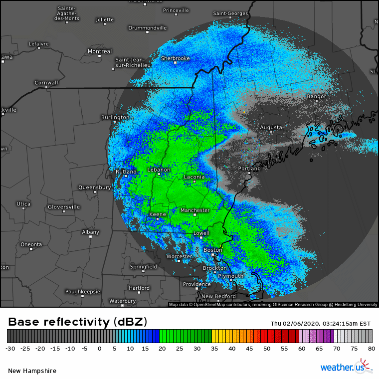
If you look closely at the image above, you’ll see a swath of grey shading that’s just a bit brighter than its surroundings. That’s the band of low clouds forming in the shadow of the Presidentials. How does it form? As air approaches Mt Washington, it can either go around the mountain or over it. If you’ve ever hiked to the summit, you’ll know that going over the mountain is a hassle (though lots of fun!). Air parcels agree with the less exercise inclined among us: better to stick to lower elevations.

About half the air parcels decide to hang a left and go up through Gorham/Route 2 while the other half decide to hang a right and head down through Crawford Notch/Route 302. On the other side of the mountain, an area of low pressure exists just downwind of the summit. Remember (almost) all the air went around the mountain either through Gorham or Conway and there’s not much left for Pinkham Notch. This area of low pressure draws the two airstreams back together. This is known as convergence. When two airstreams converge in the low levels of the atmosphere, some air must rise because too much air is attempting to fit into too small a space near the ground.

This rising motion downwind of Mt Washington happens any time there’s wind in New England. What’s unique about today is that there’s just enough moisture present to allow for the weak upward motion produced by that convergence zone to produce clouds. Unfortunately for those in Portland, those clouds happen to be right overhead this morning. By later today, we should see drier air arrive in the area so those clouds should dissipate.

-Jack

Yet Another Light Snow Event Today

Hello everyone!

We seem to be nickel and diming our way back to respectable season snowfall totals as several light snow events have occurred across the region during the past week or so. Another of these light events will impact the region today. Radar imagery shows the first round of light/moderate precip departing the coast as of 5:45 AM with a break in precip over NH/VT and another round of snow back in NY. The area of low pressure responsible for producing these bands of snow is weak, elongated, and drifting east over Pennsylvania.

As a result, I suspect most spots only have another inch or maybe two to pick up during the rest of the morning. Seeing as temps along the coastal plain range from around 30 to around 34, I wouldn’t expect any issues on road surfaces that have gotten a bit of salt. Perhaps the back roads could be slick though. Leftover snow from this system departs to the east this afternoon.

This evening, all eyes will turn to the approach of a strong Arctic front. Snow showers and squalls will develop along the leading edge of the colder air and could drop another quick coating-1″ after sunset. Behind the front, NW winds will pick up and temps will quickly drop as a brief shot of true Arctic air arrives.

-Jack

Another Generally Quiet Day Today

Hello everyone!

After our very light snow/rain event yesterday, we’re headed for more authentically “quiet” weather today as high pressure slides through the Mid Atlantic. Northwesterly flow ahead of that high will set up a familiar pattern for longtime readers and watchers of ME/NH weather. Expect mostly cloudy skies in upslope flow across the mountains while the coastal plain enjoys abundant sunshine. A few snow showers from the mountains have escaped into interior parts of York and Cumberland counties this morning, but no accumulations are expected outside of 1-3″ in the higher terrain.

High temps will once again fall on the milder side of climatological normals, ranging from 30 in the north to 40 in the south.

-Jack

Another Round Of Very Light Precip Today

Hello everyone!

Another weak area of low pressure will race by to our south today as a weak upper level disturbance zips northeast. This system won’t get its act together until it’s way out in the North Atlantic, so we can safely rule out any heavy precip. That said, there should be just enough moisture and lift to produce some scattered showers and possibly a brief period of light steady precipitation across parts of western ME and NH today. Precip is most likely between 11 AM and 5 PM in southern parts of the area. Temps will be hovering in the mid/upper 30’s over this area this afternoon, so precip will fall as a mix of rain/snow. As a result, any accumulations should be limited to <1″ on colder surfaces.

High temps will range from 30 in the north to 40 in SE NH.

-Jack

Light Snow Event Departs Today

Hello everyone!

The light snow event that has been ongoing over the past few hours will depart off to the east in the next few hours. Warm air has moved onshore in the typical spots (Midcoast peninsulas and east of 295/95 south of Brunswick) but otherwise most of the area (except southern NH) is experiencing light snow. We have about 5-6 hours of on and off snow left before drier air works in from the west. I haven’t seen a lot of reports at this hour of the morning, but there’s no reason to believe we’ll pick up any more than 2-4″ when this system is over. In the grand scheme of things, it’s a pretty weak disturbance.

High temps today will range from 32 in the northern mountains to 40 in southern NH and SW ME. A couple breaks of sun are possible in western regions this evening but otherwise today will be overcast for all.

-Jack

Clouds Return Today After A Cold And Clear Morning

Hello everyone!

Today has gotten off to a cold and clear start as high pressure crests overhead. As that high drifts offshore later today, we’ll continue with our familiar routine of increasing clouds due to warm air advection on light SW winds. Those clouds are already advancing through NY into VT/MA, but guidance suggests they may get hung up a bit this morning as a little mid-level disturbance passes through and shifts winds briefly towards the W/WNW instead of W/WSW. In any case, by this afternoon, clouds can be expected across most of the area so enjoy the sun while it lasts this morning.

Temps will rebound from seasonably cold lows last night (yes, these temps are normal for early February) to fairly average values by this afternoon. Expect high temps to range from the upper 10’s in the north to the mid 30’s in SE NH. The system approaching from the west won’t bring any precip to the area until early tomorrow morning when some light snow is expected.

-Jack

Seasonably Chilly Today

Hello everyone!

Today will feature chillier weather as a cold airmass moves in behind yesterday’s storm. Several of you were kind enough to drop your barometric pressure readings in the comments of yesterday’s post which confirmed that we were indeed dealing with a very strong storm. For those not familiar, winds are caused by horizontal differences in barometric pressure. The greater the pressure changes over some given distance, the stronger the winds will be. Since that very deep area of low pressure is now moving into the Canadian Maritimes, we have a relatively strong pressure gradient across the area this morning.

As a result, gusty NW winds are expected across the area today. These winds shouldn’t be strong enough to cause many power issues, but given that some trees and lines are still covered in snow and ice from yesterday’s storm, a few scattered outages can’t be ruled out.

With breezy NW winds, you already know what the clouds/precip part of the forecast looks like. Upsloping will bring clouds and flurries to the mountains (especially this morning) while the coastal plain should clear to sun relatively quickly. High temps will range from 10 in the north to 25 in the south.

-Jack

More Mixed Precipitation Today

Hello everyone!

Round two of our multi-part storm system will arrive today as a strong area of low pressure moves up the Appalachians. This system’s heavy precipitation will be split into two areas: one NW of the low’s track (associated with frontogenesis) and another SE of the low’s track (associated with convection). Because the low will track directly overhead, most of our area will experience light/moderate precipitation today. The exception will be up in the mountains where the strong forcing associated with frontogenesis will arrive later this afternoon.

As far as precipitation type goes, here’s a look at how the temperature changed with height above Gray ME around 7 PM yesterday. A pronounced warm layer is noted between 3,000 and 10,000 feet above the surface while the air below that is below freezing. That warm layer is melting any snowflakes that fall from the clouds higher aloft. This rain then refreezes as it re-enters the near-surface cold layer. If it has enough time to fully refreeze, it falls as sleet. If it doesn’t have enough time to fully refreeze, it will freeze on contact with cold surfaces (freezing rain).

A quick look at surface observations this morning suggest that most of the area is experiencing freezing rain with a bit of sleet farther north where that cold layer is a bit deeper.

This morning’s light freezing rain (and northern sleet) will continue until around 1-2 PM (the stop time of the loop above). At that point, the storm center will begin entering our area from the southwest. As the low passes through, winds will switch around to the north/northwest and the warm layer we have in place this morning will quickly cool below freezing.

Mixed precip will change back over to snow as this cooling occurs. While snow will be quite heavy, this storm is racing NE so fast that meaningful accumulations aren’t expected outside the mountains. That said, don’t be shocked if you run into a brief period of low visibility if you’re out and about this evening.

Here’s how much snow the NWS is expecting from this system today. I might have drawn a couple contours slightly differently, but overall my thinking is very much in line with theirs. If you’re looking for significant snow today, head north of Route 2.

As far as ice accumulations go, here’s what the NWS is thinking. Most spots along the coastal plain (away from the shoreline) and in Central NH should end up with around 1/3″ of ice by the time all is said and done. That’s not quite enough to cause major power outage issues, but it will certainly make untreated surface suitable for ice skates.

While this post is already unusually long, I wanted to end with a quick note about just how strong this storm will become as it moves up the Maine coast.

The strength of storms is typically measured by a system’s minimum central sea-level pressure. The lower the pressure, the stronger the storm. This system will challenge record low sea-level pressure values for February as it moves through CT/MA during the midday hours. The storm will be even stronger as it moves up the Maine coast, but our records are lower. That said, to get within a few mb of record low SLP values is pretty impressive.

For anyone with an analog barometer at home, it’d be worth taking a peek this evening. We don’t see values like this very often! As a final note, if you have a rotating-drum barometer that’s functional, please drop a picture of your data in the comments tonight or tomorrow morning. Model guidance has been producing some gravity wave features that myself and several meteorologists are very curious to see in the real atmosphere (if they exist).

-Jack

Messy Winter Storm Arrives Today

Hello everyone!

Today will feature the arrival of our next winter storm which will bring a prolonged period of snow, sleet, ice, and rain today and tomorrow.

Radar imagery shows steady precip ongoing across the area this morning. From what I can tell, this is falling as snow across the entire area and generally falls under the “moderate snow” category. This round of snow will be relatively short-lived (notice the drier air already working into western NH) as the weak lead disturbance responsible for producing the snow moves quickly east. Most spots should end up with 2-4″ of snow by the time precip tapers off mid/late morning.

Early this afternoon, expect little organized precipitation as we sit between the first wave (departing into Canada) and the second (still developing well to our south). Low level moisture may produce some freezing drizzle, but aside from slick untreated surfaces, impacts during this time should be relatively minimal.

Round two of this storm will arrive in the early morning hours tomorrow as steady precip returns. That round of precip will likely fall as sleet/snow up north, rain in southern NH/coastal SW ME, and freezing rain for everywhere in between. While a significant ice storm isn’t expected, a few spots in central NH/interior SW ME could see between 1/4 and 1/3″ of ice accretion. That’s generally not enough for major power disruptions, but scattered outages can’t be ruled out.

I’ll have more info on tomorrow’s half of the system tomorrow morning.

High temps today will range from 25 in the mountains/foothills to around 40 along the NH Seacoast.

-Jack

A Bit Cooler Today

Hello everyone!

A cold front pushed through the region last night, and cooler air has begun moving into the region as a result. That process will continue through the day today before the next wave of low pressure and associated push of warm air approaches tomorrow. Expect temps to range from around 20 in the mountains to around 35 in southern NH. That’ll feel relatively chilly, but believe it or not, the entire region will be within around 5 degrees of climatological norms by this afternoon. A light NW breeze will also contribute to the feeling that this airmass is colder than it actually is.

Satellite imagery shows some clearing in northern and central parts of the area this morning as dry air begins to work in from Canada. The thicker cloud deck present over southern areas will be tough to erode today, but most spots should at least get some breaks of sunshine today. The north will stay sunniest for the longest, while the NH/MA border has the best shot of remaining cloudy all day.

Our next round of precipitation will arrive in the form of snow and mixed precipitation tomorrow.

-Jack