
Hello everyone!
Round two of our multi-part storm system will arrive today as a strong area of low pressure moves up the Appalachians. This system’s heavy precipitation will be split into two areas: one NW of the low’s track (associated with frontogenesis) and another SE of the low’s track (associated with convection). Because the low will track directly overhead, most of our area will experience light/moderate precipitation today. The exception will be up in the mountains where the strong forcing associated with frontogenesis will arrive later this afternoon.
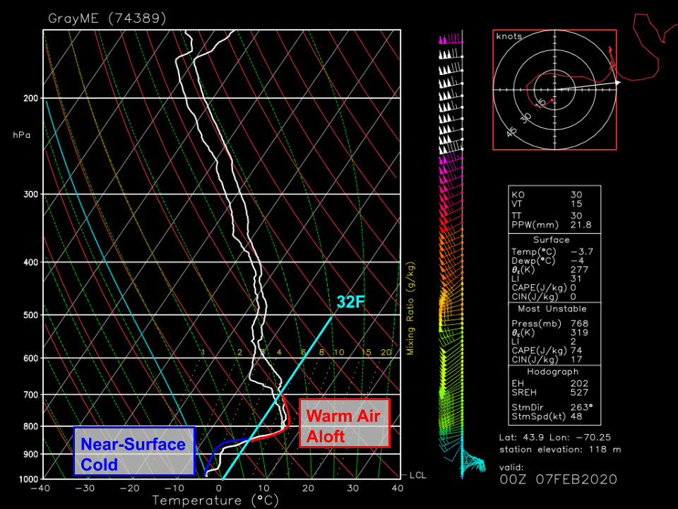
As far as precipitation type goes, here’s a look at how the temperature changed with height above Gray ME around 7 PM yesterday. A pronounced warm layer is noted between 3,000 and 10,000 feet above the surface while the air below that is below freezing. That warm layer is melting any snowflakes that fall from the clouds higher aloft. This rain then refreezes as it re-enters the near-surface cold layer. If it has enough time to fully refreeze, it falls as sleet. If it doesn’t have enough time to fully refreeze, it will freeze on contact with cold surfaces (freezing rain).
A quick look at surface observations this morning suggest that most of the area is experiencing freezing rain with a bit of sleet farther north where that cold layer is a bit deeper.
This morning’s light freezing rain (and northern sleet) will continue until around 1-2 PM (the stop time of the loop above). At that point, the storm center will begin entering our area from the southwest. As the low passes through, winds will switch around to the north/northwest and the warm layer we have in place this morning will quickly cool below freezing.

Mixed precip will change back over to snow as this cooling occurs. While snow will be quite heavy, this storm is racing NE so fast that meaningful accumulations aren’t expected outside the mountains. That said, don’t be shocked if you run into a brief period of low visibility if you’re out and about this evening.

Here’s how much snow the NWS is expecting from this system today. I might have drawn a couple contours slightly differently, but overall my thinking is very much in line with theirs. If you’re looking for significant snow today, head north of Route 2.

As far as ice accumulations go, here’s what the NWS is thinking. Most spots along the coastal plain (away from the shoreline) and in Central NH should end up with around 1/3″ of ice by the time all is said and done. That’s not quite enough to cause major power outage issues, but it will certainly make untreated surface suitable for ice skates.
While this post is already unusually long, I wanted to end with a quick note about just how strong this storm will become as it moves up the Maine coast.

The strength of storms is typically measured by a system’s minimum central sea-level pressure. The lower the pressure, the stronger the storm. This system will challenge record low sea-level pressure values for February as it moves through CT/MA during the midday hours. The storm will be even stronger as it moves up the Maine coast, but our records are lower. That said, to get within a few mb of record low SLP values is pretty impressive.
For anyone with an analog barometer at home, it’d be worth taking a peek this evening. We don’t see values like this very often! As a final note, if you have a rotating-drum barometer that’s functional, please drop a picture of your data in the comments tonight or tomorrow morning. Model guidance has been producing some gravity wave features that myself and several meteorologists are very curious to see in the real atmosphere (if they exist).
-Jack

We had a low reading of 28.6″ at 1800 on Southport.
Hi Jack, the low Bp here in Harpswell was 971.2 between 16:20 and 16:40 this afternoon on my weather station. I can’t seem to paste my graph here, but could send you the data at 5-min intervals from my spreadsheet if you’d like. Here’s from 12:59 to 18:59…
980.7 12:59
980.4 13:04
980.0 13:09
979.7 13:14
979.7 13:19
979.0 13:24
978.3 13:29
978.3 13:34
979.0 13:39
977.6 13:44
977.3 13:49
977.6 13:54
977.6 13:59
978.3 14:04
978.0 14:09
976.6 14:14
976.3 14:19
976.6 14:24
976.6 14:29
976.0 14:34
975.6 14:39
974.9 14:44
974.6 14:49
974.3 14:54
974.3 14:59
973.9 15:04
973.6 15:09
972.9 15:14
973.2 15:19
972.9 15:24
972.6 15:29
972.6 15:35
972.6 15:40
971.9 15:45
972.2 15:50
971.9 15:55
971.6 16:00
971.6 16:05
971.6 16:10
971.6 16:15
971.2 16:20
971.6 16:25
971.2 16:30
971.2 16:35
971.2 16:40
971.6 16:45
972.2 16:50
972.6 16:55
972.6 17:00
973.2 17:05
973.2 17:10
973.9 17:15
973.9 17:15
974.3 17:24
974.9 17:29
975.3 17:34
975.6 17:39
976.3 17:44
976.6 17:49
977.3 17:54
977.6 17:59
978.0 18:04
978.3 18:09
978.7 18:14
979.0 18:19
979.3 18:24
979.7 18:29
980.0 18:34
980.4 18:39
980.7 18:44
981.0 18:49
981.4 18:54
981.7 18:59
Thanks so much for posting this Doug! That data is really valuable and indeed confirms the presence of one of the features we were interested in. Perhaps I can put together a post about it tomorrow. Thanks again!!
Yes, rotating-drum instruments are the coolest!
(Santa are you listening?)
Jack, one of the best things about your posts are that they teach us about the weather. Your passion for it comes thru. Thank you for the generosity of your time to continue to give us reports. I know you’re getting paid some for this. I just wanted you to know how much we appreciate you and your reports.
Thanks so much Mercer! Glad you appreciate the writeups
I do have a recording barograph as will see if I can post a picture either later today or tomorrow.
Awesome, thanks!