I’m a third-year atmospheric science student at Cornell University who has been blogging about the weather since 2011. While I’m not officially a meteorologist, I have accumulated a bit of experience forecasting both local weather (in western Maine and New Hampshire) as well as national/international weather during my time writing for weather.us and weathermodels.com. I also have experience programming in Python, teaching concepts in weather forecasting, and communicating forecast information to general audiences.
Today will feature the return of seasonably cool air as yesterday’s outrageously warm airmass departs into eastern Canada. The cool air will be brought to us by WNW winds that are likely to be quite gusty. Expect winds in the 35-45 mph range for most areas except the typically windy ridgetops and typically calm valleys in the mountains. These winds are just about at the right intensity to bring the threat for some power outages, though widespread disruptions are not expected.
Temps will generally be on a downward trend today, starting off in the upper 30’s north and mid 40’s south before ending up around 20 in the north and 30 in the south this evening. Skies will be partly to mostly cloudy today, with the best chance for sunshine along the coastal plain.
Heavy rain is falling across the region this morning as low pressure develops over the Mid Atlantic. As expected, the entire region has warmed above freezing and no additional icing issues are forecast. The batch of rain moving through currently will be the steadiest and heaviest of the day, so watch out for localized street flooding/ponding on roads during the morning commute.
During the mid-morning hours, drier air will work into the region about 5,000 feet off the ground. This will shut off the steadier/heavier precipitation, and most of the area will remain dry (possibly with some drizzle) through the mid afternoon hours. Another round of moderate/heavy rain, this time in the form of convective showers, will arrive from the south this evening, likely around 6 PM in southern NH, 7 PM near Portland, and 8 PM for the mountains. The process of returning this warm airmass to its rightful place in the tropics will begin tomorrow with gusty NW winds.
High temps today will range from 40 in the mountains to 55 along the coast.
Today will feature the beginning of a warming trend that will continue as our next storm rolls through the area tonight and tomorrow. The storm will be tracking to the west of the region, which means that aside from some light snow/sleet/freezing rain associated with the leading edge of the precipitation, this one will be all rain.
That leading-edge icy precipitation will arrive later this afternoon, but it will be very light and is only expected to last for a couple hours at most. If you’re headed out and about after 7 PM, especially away from the coastline, watch out for isolated slick spots but otherwise you’ll barely notice the couple flakes or ice pellets. Steadier and heavier precipitation arrives later tonight, and will almost exclusively fall as rain except perhaps for the coldest mountain/foothill valleys where light icing will continue until tomorrow morning.
High temps today will range from 30 in the mountains to 45 along the NH Seacoast.
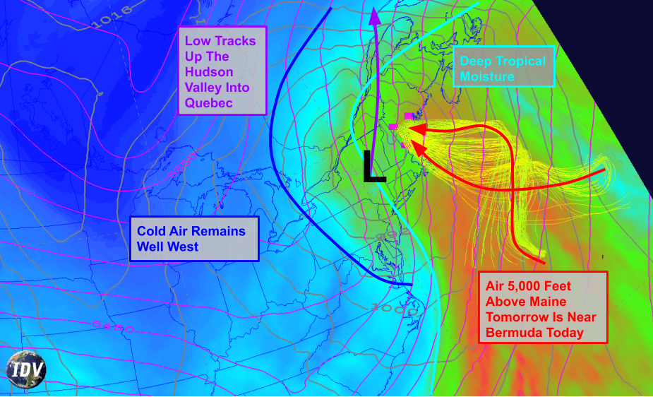
Curious why the storm tonight/tomorrow is expected to be mostly/all rain? Here’s a snapshot of one of the tools I use to figure out if it’s going to rain or snow. The shading depicts moisture content, with blue indicating dry air and green/red indicating moist air. Maine is firmly on the “moist” (east) side of the storm system, the center of which is tracking through the Hudson Valley. The moist side of the storm is also the warm side of the storm, and the airmass forecast to be over Maine tomorrow can be traced back to the Atlantic Ocean near Bermuda today.
With the storm passing to our west and air moving in from Bermuda, we can have high confidence that this one will end up mostly rain, even in the mountains.
Fellow snow lovers can take solace in the fact that this storm appears to be jolting our weather pattern back towards a more favorable configuration for cold air and snow, and there’s a pretty good chance most of the area ends up with a White Christmas (defined as >1″ of snow depth on Christmas morning or measurable snow accumulation >.1″ during Christmas Day).
Today will feature mostly clear skies and cool temps as a cold airmass continues to move into the region from Canada. This airmass is dry enough that even the upslope clouds along/northwest of the mountains will be relatively sparse. NW winds will continue gusting up to 30 mph today, which isn’t enough to be worried about power outages but will certainly make walking outside unpleasant if you’re not prepared. Later in the day, some high clouds will arrive from the WSW ahead of our next storm system which will bring rain to the region this weekend.
High temps will range from a little below 20 in the north to a little above 30 in the south.
Today will feature a brief brush with light snow during the morning hours as a wave of low pressure slides north along the frontal boundary that moved through yesterday. This is a weak and fast-moving system, so don’t expect much in the way of snow, especially in the mountains. Parts of the coastline could see a quick 1-2″ before the snow tapers off in the next 2-3 hours.
Some clearing is expected behind this system during the midday hours before mid/high clouds approach again this evening ahead of our next cold front. High temps today will range from 20 in the north to 35 in SE NH.
Today will feature more near-record warmth as southwesterly flow continues ahead of an approaching cold front. High temps will range from 45 in the north to 60 along the NH Seacoast. Most of the rain associated with this system moved through the area last night, but a few showers are possible as the front itself crosses the area during the mid/late afternoon hours. Behind the front, northwesterly flow will begin bringing temperatures back towards where they should be this time of year, and a more seasonable airmass is expected by tomorrow.
Today will feature the arrival of steady rain as our next storm system moves well to the west of the area. Rain will arrive from the southwest during the midday hours, reaching SW NH around 10, Portland around noon, and the Augusta area by 2 PM. Rain will generally be steady and of a light to moderate intensity, though some heavier pockets can’t be ruled out. Steady rain will continue into the evening before we dry out a bit early tomorrow morning.
It’s always wise to be skeptical of warm air’s capability to advance into Maine/NH, especially this time of year. However, we’re lacking a classic “cold air damming” situation with northerly or northeasterly winds and a strong area of high pressure in Quebec. As a result, while pockets of freezing rain are likely in the foothills and mountains especially earlier in the day today, everyone should see a changeover to plain old rain by the middle of the afternoon. High temps will range from 35 in the mountains to 50 along the coast, with the warmest air arriving in the evening.
Today will feature the last day of cool and quiet weather for at least a little while as our next storm system begins to approach from the west. Clouds from this system will begin moving into the region this afternoon, but most of us will enjoy plenty of sunshine during the morning and midday hours. Winds will turn towards the southwest today, meaning warm air will begin heading in our direction. That being said, the warm airmass needs to break down the deep snowpack across NY and MA before it can arrive in NH/ME, so we’ll be left with another day of relatively cool temps today. Look for highs ranging from 25 in the north to 30 along the NH/MA border.
Enjoy the nice weather! If you’re a skier or snowboarder, today is the day to hit the slopes for one last shot at the soft snow left by the post-Thanksgiving storm. If you’re thinking of heading out next weekend, sharpen up those edges.
Today will feature the return of generally quiet weather across the area as high pressure slides into the region from Canada. Look for mostly sunny skies, cooler temps, and light winds across the entire area as that high pressure moves in. High temps today will range from just below 20 in the mountains to just below 30 along the NH Seacoast. Enjoy the nice weather, today’s a great day to hit the slopes before rain arrives on Monday!
A fast-moving clipper system will cruise past the region today, bringing a round of light snowfall to the southern half of the area. Snow will arrive in SW NH around noon before moving into western Maine around 3 PM. While snow will be steady, and could even be heavy at times, the system is moving very quickly so 1-3″ is about all we’ll get across southern NH and York County Maine. Farther north, lighter bands of snow will drop a dusting-1″ of snow across central NH/southern Maine while far northern and northeastern parts of the area are unlikely to see more than flurries.
High temps today will range from 20 in the north to 32 in far southern NH.