I’m a third-year atmospheric science student at Cornell University who has been blogging about the weather since 2011. While I’m not officially a meteorologist, I have accumulated a bit of experience forecasting both local weather (in western Maine and New Hampshire) as well as national/international weather during my time writing for weather.us and weathermodels.com. I also have experience programming in Python, teaching concepts in weather forecasting, and communicating forecast information to general audiences.
Today will feature the approach of another Arctic cold front as our cool and active pattern rolls along. The front won’t cross the region until this evening, which means we’ll spend most of today on the warmer side due to southwesterly flow ahead of the boundary. Additionally, coastal areas will likely enjoy several hours of sunshine this morning which will further boost temps. As a result, SE NH is likely to approach 50 degrees this afternoon while rest of the coastal plain tops out in the 40’s and the mountains remain stuck in the low/mid 30’s.
The front will enter the mountains during the mid-evening hours with a line of snow squalls that will result in low visibilities and a quick coating-1″ of snow. These squalls will lose much of their momentum as they move SE of the mountains later in the evening. Another cold airmass will move in on gusty NW winds later tonight into tomorrow.
Our next Arctic cold front lies in wait across Ontario this morning, which means we’ll start to see the telltale high clouds spreading across the region today. The developing overcast will inhibit solar heating, and with current temps near record lows for this time of year, another chilly day can be expected today. Highs will range from the low 20’s in the north to the mid 30’s in southern NH.
One neat thing that may happen today is ocean effect snow. The airmass that has spread across the East Coast is so cold that as it retreats ahead of the next front, its passage over the warm Gulf of Maine waters will create enough instability for ocean effect snow showers. The best chance for some flakes this afternoon will be northeast of Portland, and no accumulation is expected. Otherwise, the next chance for precip will arrive tomorrow evening in the form of snow squalls.
Today will feature clearing skies and chilly temps as high pressure finally arrives over New England following the departure of yesterday’s storm system. High temps will range from a little below 20 in the north to a little below 30 in the south. That’s pretty chilly for this time of year! As the high gets closer today, NW winds will slowly taper off, but gusts are likely to remain above 20mph for most of the day which will make the cool temps feel even colder. Aside from a few upslope flurries this morning, no precipitation is expected.
A jumbled mess of precipitation types is in progress across the area this morning as warm air has surged northward just above the surface, while cold air remains in place through the lowest few thousand feet of the atmosphere. For most of us, that means either sleet or freezing rain is falling at the moment. For eastern parts of the area, dry air in the mid levels means that the clouds can’t produce enough ice crystals to melt into freezing rain as they fall, and we’re left with freezing drizzle. While these are two distinct phenomena scientifically, they both produce the same result: slippery roads/sidewalks.
The storm’s cold front will approach from the west during the midday hours today, which will gradually replace this morning’s drizzle with actual steady precip. Initially, most of it will be in the form of freezing rain and/or sleet, but as cold air rushes in from the west, we’ll all switch over to snow for a couple hours before the arrival of drier air brings precip to an end this afternoon.
As far as temps go, cold air is dammed east of the mountains this morning, and likely won’t be moving in a hurry. It’s possible the turbulent mixing associated with the cold front could briefly bring temps from their current readings around 30 up into the mid 30’s, but any such warmth would be short-lived. Temps will fall region-wide this afternoon as gusty NW winds take over. By this evening, most of the region will see temps between the mid 10’s and mid 20’s.
A messy winter storm will begin impacting the region later today, and will bring with it the full range of precipitation types including rain, snow, and everything in between. The precipitation won’t begin until the early/mid afternoon hours, however, so we’ll have several dry/overcast hours this morning before we need to worry about frozen precip and slick roads.
By 5PM, snow will be falling across most of the area’s northwestern half as the mid-level warm front associated with this system moves north. If you’re north of a roughly Lebanon NH-Lewiston-Belfast line, you can expect a period of snow this afternoon amounting to between a coating and 2″ with the highest totals in the northern mountains.
Steadier precip will develop later this evening as low pressure tries to intensify over the Ohio Valley. With warm air surging northward in the mid levels, expect a swift changeover from snow to sleet and freezing rain, especially SE of the mountains. Some model guidance insists that above-freezing air will arrive at the surface, changing precip over to rain, but this setup is ripe for cold air damming so outside of far SE NH and some of the Midcoast peninsulas, I expect temps to remain below freezing during this event.
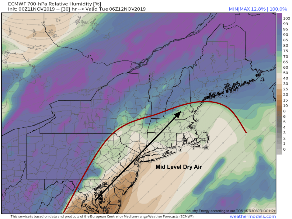
Later tonight, mid level dry air will race into the region ahead of the storm which will be moving through PA/NY. This means that we won’t be able to produce ice crystals in the clouds, so even if it were cold enough for snow, the flakes couldn’t form. As a result, everyone not within ~30 miles of the Canadian Border will go over to freezing drizzle (distinct, believe it or not, from freezing rain!) for several hours. While ice accretion will likely remain below the threshold for power outage impacts, this freezing drizzle will add a very slippery layer to sidewalks and roads before the Tuesday morning commute.
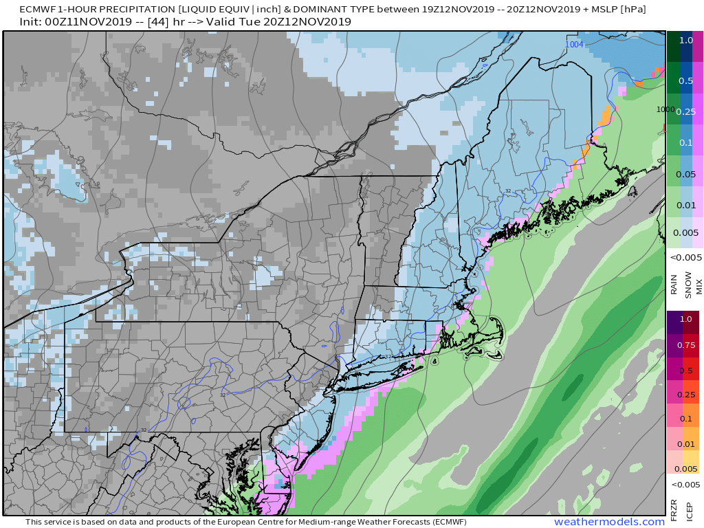
During the day tomorrow, we’ll see the back side of the storm move through. NW winds will rapidly bring colder air back into the region at all levels of the atmosphere, so a burst of moderate snow is likely. The snow falling on top of tonight’s ice layer will create very slick travel conditions for the PM commute.
Overall, most of the region won’t see appreciable snow accumulation >2″, with the exception being the far NW mountains where over 6″ is possible.
I’ll have more info on tomorrow’s half of the storm tomorrow morning.
Today will feature increasing cloud cover as our next storm system slowly approaches from the west. Southwesterly winds ahead of this system will boost high temps several degrees above where they’ve been over the past few days, ranging from 40 in the north to nearly 50 in the south.
Precipitation associated with the incoming storm will hold off until tomorrow. Heavy snow is expected in the mountains, while freezing rain falls closer to the coast. More details on that will be posted tomorrow morning.
Today will feature cool temps and quiet weather as high pressure slides offshore just to our south. Over the course of the day, winds will shift towards the southwest, which means milder air will begin moving towards the region. That being said, the whole East Coast enjoyed the same airmass we did over the past few days, so the air to our southwest isn’t all that warm. High temps will reflect that, ranging from around 30 in the north to around 40 along the NH Seacoast.
Skies will be mostly sunny during the first half of the day today, with a few clouds filtering in from the west during the afternoon. Our next round of rain and snow will arrive Monday/Tuesday.
Today will feature seasonably chilly weather as cold air moves into the region from Canada on brisk NW winds. High temps will range from 25 in the north to 35 in the south, with wind chill values considerably colder.
The NW winds will set up a classic upslope/downslope pattern with mostly sunny skies expected along the coastal plain and overcast conditions likely along and upwind of the mountains. Today’s pattern is also set up favorably for accumulating upslope snows, and the typically favored NW-facing slopes will pick up several more inches of snow during the day today, with a few of those flurries making their way down into the foothills.
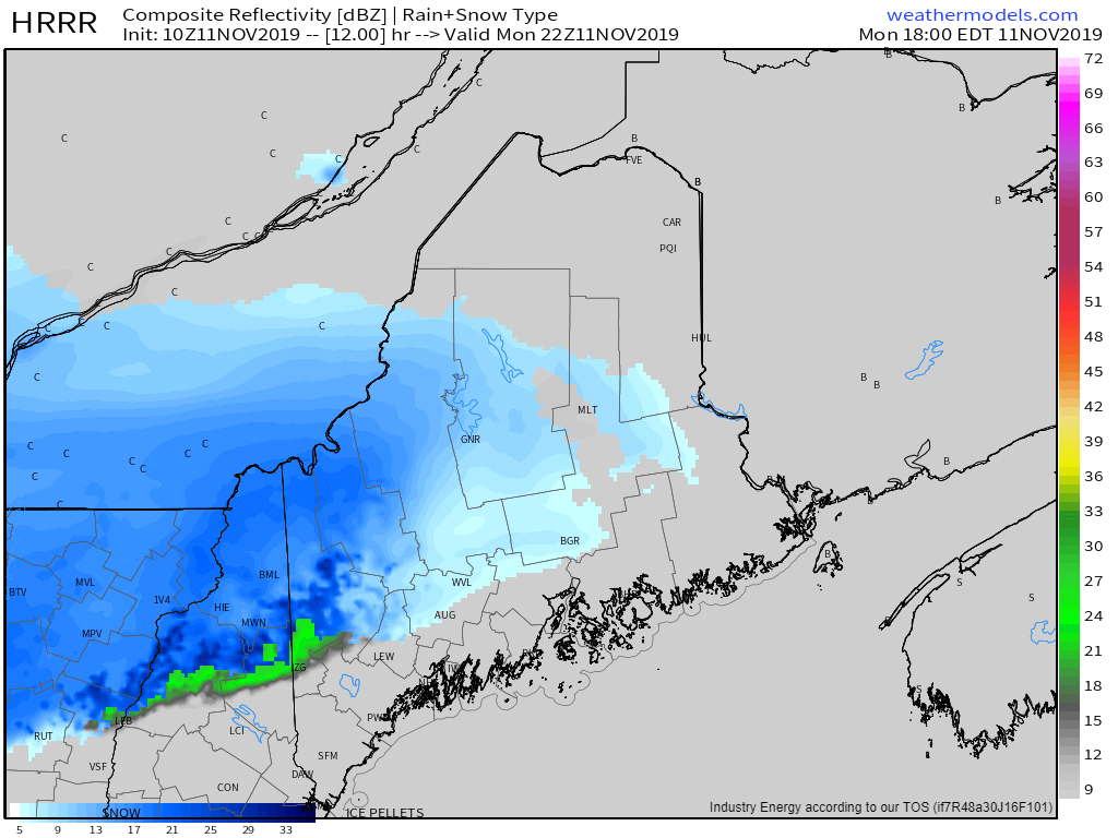
A cold front will be moving through the region today, and it will be responsible for producing the first flakes of the season across many areas. Currently, temps outside the mountains are on the warmer side (in the low to mid 40’s), but evaporation into the low level dry air and importation of cold air from Canada will join forces to push temps in the downward direction this afternoon. Up in the mountains, light snow has already been reported with temps below freezing.
For this morning, light snow will continue in the mountains while rain showers approach NH from the SW. Expect rain to expand into Maine during the early afternoon hours before the rain/snow line begins its march south during the mid/late afternoon. Most folks in the mountains will likely see 2-4″ with higher totals as you gain more elevation. A dusting is possible in the foothills while no accumulation is expected along the coast. The exception to this will be interior parts of the Midcoast (between Augusta and Belfast) where up to 1″ is possible as precip will linger later into the night over those areas.
High temps today will range from 30 in the north to 45 along the coast.
More cold and snow is expected over the coming week, so now is a good time to dust off the winter gear if you haven’t already!
High pressure drifting slowly through the Ohio Valley will bring quiet weather to the region today. Expect more sun than clouds, especially downwind of the mountains. High temps will be a little on the cooler side of seasonable, ranging from around 30 in the north to around 50 in the south. No precip is expected today. Our next round of rain (and this time some snow too!) will arrive later tomorrow.