All posts by Jack Sillin

I’m a third-year atmospheric science student at Cornell University who has been blogging about the weather since 2011. While I’m not officially a meteorologist, I have accumulated a bit of experience forecasting both local weather (in western Maine and New Hampshire) as well as national/international weather during my time writing for weather.us and weathermodels.com. I also have experience programming in Python, teaching concepts in weather forecasting, and communicating forecast information to general audiences.

Storm Departs Today

Hello everyone!

Today will feature the departure of yesterday’s storm in fairly traditional fashion as NW breezes pick up. Scattered snow showers this morning will clear up along the coast by this afternoon, and remain ongoing in the mountains. Additional upslope accumulations of 1-2″ are possible in the favored spots. As skies clear in the south, look for temps to warm up a bit above freezing. Meanwhile in the north, the clouds and colder airmass will hold highs to about 30. Scattered power outages are possible especially in the foothills and mountains today as breezy winds put stress on trees already loaded with heavy wet snow.

-Jack

Tricky Late Season Winter Storm Today

Hello everyone!

This morning’s post will be a bit lengthier, as we have a storm of substantial interest in the forecast for today. The general summary is that low pressure moving through Southern New England will bring heavy precipitation to the region today, some of which will fall as snow. Who exactly sees snow vs rain and how much that snow accumulates is where the tricky part of the forecast comes in.

Mountains:

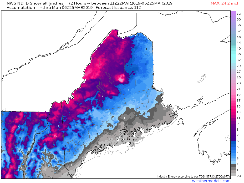
This appears to be a mostly snow event for the mountains, especially at higher elevations above 2,000 feet. Here, 12-18″ of snow is likely through the day today. Wax up those powdah skis and wish your boss a nice weekend, this might be the last time for a while we can enjoy smooth powdery turns. Expect temps around 30 this morning to drift up towards 32 this afternoon.

Foothills:

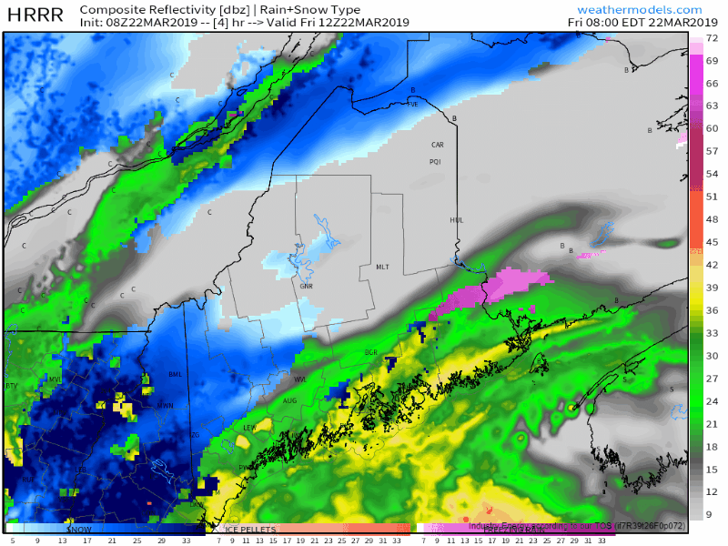
What an interesting and tricky forecast for the foothills. Lewiston is reporting 34 and light rain as I write this a little before 8 AM, but an area of heavy precipitation awaits just offshore. As those heavy bands move in, air will begin rising rapidly through the atmosphere, cooling as it does so. Additionally, the process of melting snowflakes will begin to take warmth out of the air via latent heat exchange. The net result will be a dynamic cooling of the lower atmosphere to right around 32F, which will allow for a changeover to snow.

Here’s a visualization of that changeover as the heavy banding arrives. Snow that falls during this time will be heavy and wet, but could accumulate relatively efficiently given strong dynamics aloft.

As we move later into the midmorning hours, warm air will attempt to resume its march northward. Exactly how fast this process plays out will be critical in determining which parts of the foothills get 4-8″ of snow, and which get 2-4″. Higher elevations will hold onto snow longer. Eventually by later this afternoon, precipitation will lighten in intensity and once we remove the dynamic cooling processes, we’ll likely get the changeover back to rain. Temps will hover right around freezing this morning before rising into the mid 30’s this afternoon.

It should be noted that warm air has a notoriously hard time invading the foothills, so there is an outside chance that those areas remain around freezing for the rest of the day, and a wider swath picks up more than 6″.

For those areas that do see several inches of heavy wet snow, power outages are something you should be prepared for given the weighing down of tree limbs and the potential for some breezy conditions later this evening.

Coast:

Along the coast we have another tricky forecast. Many coastal sites are reporting light snow or mixed precipitation this morning, and with the heavy precip banding now trying to move onshore, it’s possible that dynamic cooling briefly sustains this. A brief coating-2″ is possible in the next couple hours before a changeover to heavy rain. Some embedded thunderstorms are even possible in Penobscot Bay later during the lunchtime hour as deep tropical moisture rushes north. Temps will start in the low to mid 30’s this morning and rise into the upper 30’s to low 40’s this afternoon.

With strong onshore winds and astronomically high tides, watch out for some minor coastal flooding in the typically vulnerable areas this afternoon especially south of Portland.

Precip will become lighter and spottier for the entire region this evening, with cold air beginning to rush back into the area tonight. As this happens, watch for black ice to rapidly develop on previously wet roads.

Graphics used in this post come from weathermodels.com, an excellent source for weather data visualizations if you’re interested in going a little bit more in depth with your weather watching.

-Jack

Milder But Cloudier Today

Hello everyone!

Today will feature warmer temps that come at the cost of cloudier skies. The reason for both is the approach of a cold front from the Great Lakes, which is both dragging warm air north and spreading cloudiness east. High temps will range from 35 in the mountains to 45 in the foothills to 40 along the immediate coast. Most of the day should be dry, but parts of NH could see a few rain or snow showers this afternoon, with the best chance for flakes in the higher terrain.

More organized precip arrives tomorrow and will fall as snow at higher elevations, with rain for most of the rest of us.

-Jack

A Pleasant First Day Of Spring

Hello everyone!

For those excited about warmer weather, today marks the first day of astronomical spring, where the sun’s most direct rays are cast on the equator. The first day of spring also marks an interesting moment where everyone on earth sees (approximately) the same amount of daylight. No matter whether you’re at the North Pole, near the Equator, or somewhere in between, today will feature about 12 hours of daylight (give or take a little based on topography, refraction, etc.).

Enough about astronomy, what about today’s weather? It will be pretty quiet across the region. Look for sunny skies this morning shifting over to a mix of sun and clouds this afternoon. Temps will range from 35 in the mountains to 50 in the south. Along the immediate coast, a sea breeze will develop this afternoon and keep temps in the 40’s.

-Jack

More Quiet Weather Today

Hello everyone!

Another quiet day can be expected today as high pressure lazily drifts by to our south. Skies will be partly to mostly sunny, with a few more clouds popping up this afternoon from daytime heating. High temps will range from 20 in the north to 45 in the south. Enjoy the lovely weather!

-Jack

A Calm Late Winter Day Today

Hello everyone!

Today will feature calm conditions and generally seasonable temps for this time of year. Expect NW flow to weaken, which will result in upslope clouds dissolving. With upslope out of the way and generally dry air across the region, we can expect mostly sunny skies today. High temps will be seasonably cool, ranging from 20 in the north to 40 in the south.

-Jack

A Shot Of Cooler Air Today

Hello everyone!

A shot of colder air will slide through the region today, bringing with it more upslope/downslope flow and temps well below yesterday’s readings. In the mountains, mostly cloudy skies will remain entrenched while temps rise to about 15-20 degrees. Snow showers are also expected, especially this morning, with little to no accumulation. The foothills can expect a mix of sun and clouds, some morning flurries, and highs in the mid to upper 20’s. Along the coast, temps will rise to around freezing with mostly sunny skies.

-Jack

One More Milder Day Today

Hello everyone!

The mild airmass that brought us yesterday’s warm temps is slowly on its way out today, but we’ll get one more day of mild weather today as NW breezes slowly bring cooler air into the region. Those NW breezes will set up an upslope/downslope pattern for clouds and precip, with overcast skies expected in the mountains/foothills and more sunny breaks down along the coast. The clouds in the mountains are likely to produce some snow showers, with accumulations in the 1-3″ range for the favored notches/slopes. Temps will follow a similar gradient as cloud cover, ranging from 30 in the north to 45 in the south.

-Jack

Very Mild Today

Hello everyone!

Today will be the mildest of this week’s warmer pattern, with the cold front sitting just to our west. Expect more clouds than sun today, along with pop up showers that develop due to warm-sector instability. Perhaps if we’re lucky one or two of those showers will develop enough to produce a clap of thunder or two. The best chance of showers will be in the mountains during the mid morning hours.

As for temperatures, they will be quite warm, ranging from 45 in the north to 60 in Southern NH.

More seasonable weather returns tomorrow.

-Jack

The Warmup Continues

Hello everyone!

Today will feature continued warming as mild air flows north ahead of a powerful storm in the Plains. Expect high temps to range from 40 in the mountains to 55 in Southern NH. Some low clouds and fog are noted on visible satellite imagery this morning, and a mix of sun and clouds is expected across the area today as upper level cloud cover spills over the top of the upper level ridge located overhead. The rain from this system will hold off until tomorrow, but thankfully it won’t be too heavy.

-Jack