Tag Archives: gulf of maine

Full update on winter storms

We are now on a wild roller coaster ride when it comes to the weather in the North East. A low pressure system is moving out of the Great Lakes and will be transferring its energy to a secondary low off the NJ coast.

noreaster 12


Graphic overview of storms.

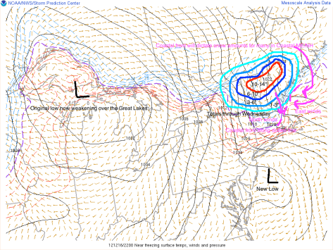
As you can see, there are many factors playing into the forecast. The coastal front, the new low, cold air damming. Cold air damming is when  the heavy cold air stops the advance of Warm air. Where exactly the cold air dam sets up will play a big part in the type of precipitation. The coastal front will play an equally important part on determining precipitation types. As shown, the east winds off the warm water will bring in warmer air. This will turn snow/sleet/freezing rain into all rain. Expect this to move inland Monday-tuesday.

After the coastal front moves inland, Wednesday will already be here as will another storm. This new storm will be MUCH stronger.

noreaster 13


This graphic depicts the setup Monday-Wednesday. The coastal front from tonight will move way inland turning everyone except the ski resorts over to plain rain. The wednesday low will move swiftly through the Gulf of Maine and into the Canadian Maritimes. On the backside of this system the cold air will make a comeback turning everyone back over to snow Wednesday evening-night. Accumulations should be light.

After we get the Monday and Wednesday storms out of the way, there will be yet another low Friday. This is a little too far out to accurately forecast so I will detail that in a later Post coming Wednesday-Thursday.

-Jack

Snowy stretch ahead for New England while Mid Atlantic Enjoys Mainly Quiet Weather

Overview: Strong low pressure will move swiftly out the mouth of the St Laurence and has already pushed a cold front through overnight. Strong winds will develop behind the front bringing in cold air. Winds will gust to close to 50 mph out of the W or possibly WNW or NW. Tomorrow will feature clouding skies and a lot less wind. Thursday night will bring a clipper system to the area developing a coastal low in the southern Gulf Of Maine. These two systems will bring close to 6″ to the midcoast and Central Maine with 4-5″ along the coastal plain ( the waterline to around 10 miles inland) with 2-4″ in the mountains 3-5 is likely in the far north. Saturday will feature a second clipper system and coastal low so the results will be very similar to that of the Thursday night storm. Monday will feature yet another storm and since the models diverge and the storm is in the long range forecast details are uncertain but we do think that as of right now it looks like a wintry mix along the coast with more snow inland.


Details: Winds will pick up as the day goes on peaking at around 9am with 50+ mph gusts and sustained winds peaking at around the same time at 25-30 mph. This wind will bring in colder air and will set the stage for two systems which will affect the area Thursday and Saturday nights.These two systems will bring close to 6″ to the midcoast and Central Maine with 4-5″ along the coastal plain ( the waterline to around 10 miles inland) with 2-4″ in the mountains 3-5 is likely in the far north. After that we will find a quiet and cold end to the weekend. Monday however will be different with temps at the coast in the mid 30s so at this point it looks like a tricky forecast and a mix at the coast.

Mid Atlantic: Windy today but winds will calm as the day goes on and become cooler. This cooler air will set the stage for some flurries for Thursday night although the southern sections will not get too much precipitation in the next week with Thursday and Saturday nights being the only two times precipitation in the southern sections. The northern sections however will get some more prolonged snow showers Thursday and Saturday nights which could leave a coating to an inch on grassy surfaces.

Stay tuned!

-Jack