Tag Archives: heavy snow

Powerful And Slow Moving Blizzard Slams The Region Tonight Into Tomorrow


blizzard impact map

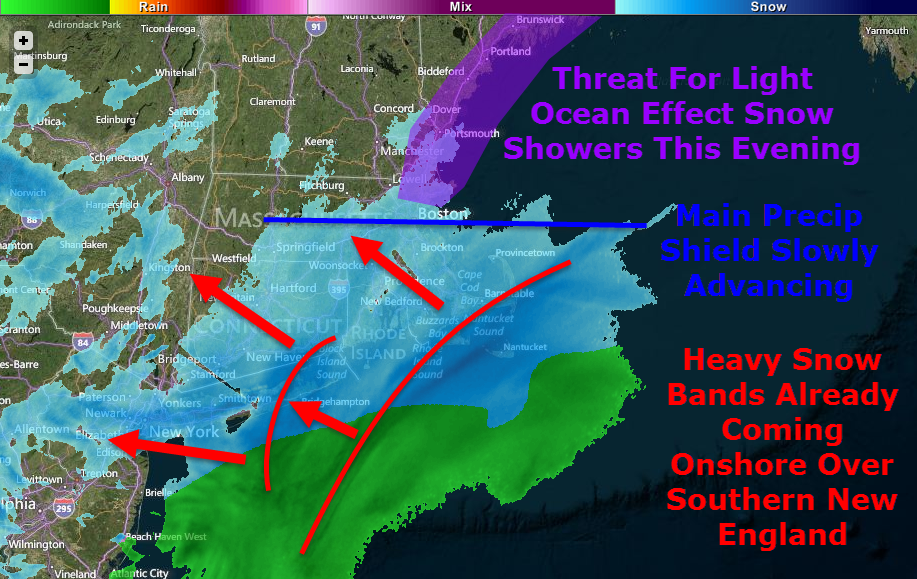
It’s here, go time, T-0. Heavy snow is already moving onshore across southern New England as light ocean effect snow showers organize across coastal Maine and New Hampshire. The main precip shield, as of 5:30, is located just north of Boston extending almost due west and is slowly moving north.

While I try to keep things under control in the technicality department, some higher level terms will be thrown around. Any words that show up in green, signaling a link, will take you to the glossary I have compiled with more information. Suggestions are welcome regarding terms you would like to see added to the glossary.

blizzard map 1

A busy water vapor satellite image shows well the components of our storm coming together. This is really a textbook storm with high latitude blocking, a strengthening low at all levels of the atmosphere, a deep tropical connection, and more reserve energy waiting to drop into the storm up in the Great Lakes. The storm’s strong baroclinic leaf consists of the broad blue area from Maine to Maryland and offshore. Just how many and how far-reaching will the impacts from this storm be? Hint: there are quite a few and they will cover all the bases.

Snow

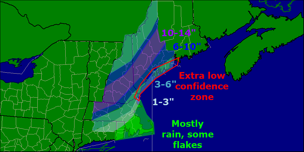
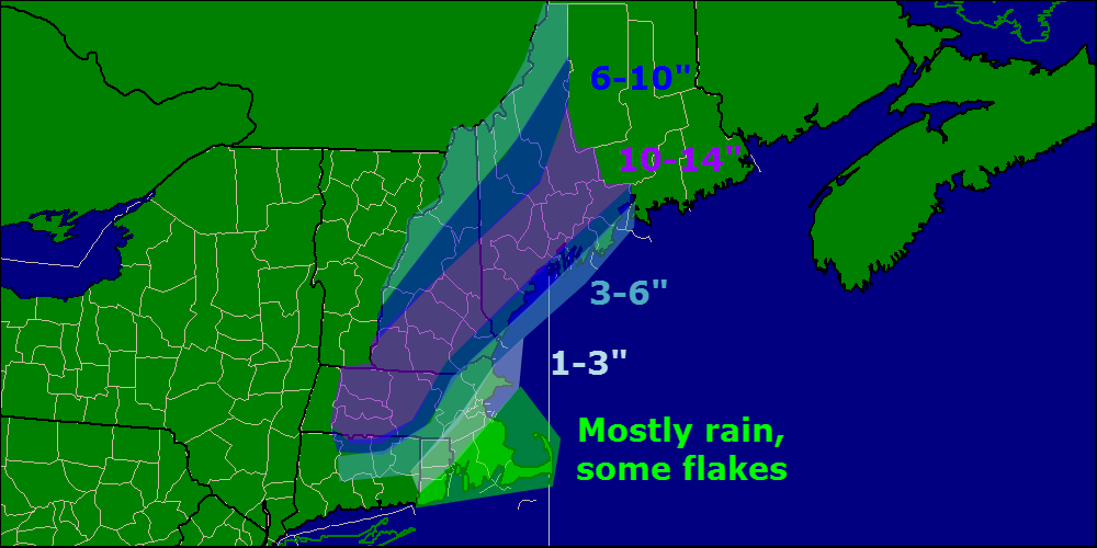
Lots of snow is expected with this one, no doubt about it. Widespread 1-2′ amounts are expected with slightly less in the far north and along the cape while areas west of Boston stand the greatest chance for over 2′ to as much as 3′ of snow.

There are a few reasons for such high snowfall totals, first, this will be a rapidly strengthening storm. pressure is already falling fast off the Carolina coast and the low is quickly gaining steam. When you have a rapidly intensifying storm, you get intense upward motion on the NW side which brings very heavy snow.

Nam vertivelo

This map is the NAM vertical velocity map for 7AM tomorrow showing an intense band of snow along coastal Maine. This band will later move inland bringing heavy snow all the way to Canada. In areas highlighted in pink, extreme snowfall rates on the order of 1-3″ per hour will be widespread along with enhanced winds along with the potential for thundersnow. Image courtesy, Accuweather.

Another reason for high snowfall totals will be the dry, fluffy nature of the snow which can accumulate very efficiently. Temps in the single digits to low teens will keep snow dry and powdery for the duration as well as keep the threat for mixing well to the south and east.

One last contributing factor to mention is the fact that the storm will stall out southeast of Nantucket for about 12 hours tomorrow and will keep rotating heavy bands onshore through the entire day rather than skirting right out to sea. With many hours of heavy, efficiently accumulating snowfall, amounts will approach or even exceed 2 feet in many areas.

Wind

Wind Gusts In Knots Off The 12Z GFS Courtesy: Accuweather
Wind Gusts In Knots Off The 12Z GFS. Courtesy: Accuweather

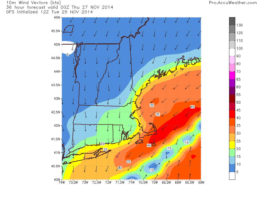
With a rapidly intensifying low to our SE and a strong, stubborn high to our NW, the pressure gradient will be extremely tight. Wind gusts exceeding 60 mph are likely along all of coastal ME and NH extending all the way through Eastern MA, RI, and Eastern CT. Coastal SE MA will likely see wind gusts over hurricane force Tuesday morning. Inland areas will see wind too, though less violent than coastal areas. Gusts exceeding 35mph will be common region-wide.

Winds this strong, no matter the circumstance, will bring down tree limbs and power lines so power outages are a very real threat across coastal areas. The power outage threat will extend inland though will be mitigated somewhat by friction and thus lower wind speeds.

Blowing/Drifting Snow, Blizzard Conditions

Official Warning Map From NWS Gray Showing Blizzard Warnings Along The Coast With Winter Storm Warnings Inland

The combination of high winds and powdery snow will cause extended whiteouts across coastal areas on Tuesday. For this reason, the NWS has issued Blizzard Warnings for the coast as well as adjacent inland areas. To qualify as a blizzard, a storm must produce falling or blowing snow combined with winds of over 35 mph reducing visibilities to 1/4 mile or less. All these criteria must be met for 3 hours or more to qualify. All areas should expect scattered blizzard conditions but the coast is likely to meet the official criteria for a blizzard event.

With such high amounts of snow forecasted combined with high winds, drifting will also become a legitimate concern especially for those areas in the blizzard warning. Drifts up to 4 feet are possible in some highly localized areas with other spots seeing bare ground as the snow is blown somewhere else.

Coastal Flooding

blizzard waves

A prolonged period of strong onshore winds almost always results in coastal flooding and this time is no different. The map above is off the Wave Watch III model, courtesy of Accuweather, which shows 24 foot seas just offshore. While the more northerly component of the storm will mitigate the threat somewhat, the coast will take a bit of a beating for sure.

For these reasons, the NWS has issued a Coastal Flood Warning for the entire coast which I totally agree with due to the expected 1-4 foot storm surge plus the strong wave action. Expect moderate to, in some places major coastal flooding with the high tides on Tuesday. Things will settle down somewhat Wednesday though some residual wave action may cause some minor problems.

Timing/Travel Impacts

Below I will break down the timing along with travel impacts. The scale for travel impacts goes Minor, Moderate, Major, Severe, Extreme, Extreme Do Not Travel. If you must travel, always consult the latest NWS information.

Tonight – Snow builds in from South to North becoming heavy at times later on tonight. Travel impacts: Moderate.

Tomorrow Morning – Very heavy snow bands rotate in off the ocean causing extremely heavy snow which, combined with high winds, will cause travel to become impossible. Travel impacts: Extreme. Do Not Travel.

Tomorrow Afternoon – Heavy snow sticks around though the extreme snow moves out. Winds will still be whipping causing continued whiteout conditions. Travel impacts: Extreme.

Tomorrow Night: Heavy snow moves out, steady moderate snow remains. Winds die down slightly though whiteout conditions can still be expected. Travel impacts: Severe

Wednesday Morning: Light, but steady snow remains with some moderate bands. Winds will continue to die down but blowing and drifting will remain an issue. Travel impacts: Major/Moderate

Wednesday Afternoon: Steady snow moves out leaving patchy snow showers/squalls. Winds however will keep the threat for blowing and drifting snow around long after the flakes stop falling. Travel impacts: Moderate.

Wednesday Night: Clearing begins, some blowing/drifting still possible mainly in the evening as winds continue to let up. Travel impacts; Minor.

Recap

All in all, this will be a big storm, but probably not record-breaking at least for Maine. Widespread 1-2′ amounts are likely with the bullseye for 2’+ being west of Boston. Highs winds will whip the snow into a frenzy and cause blowing and drifting along with whiteout conditions. The peak of the storm will be Tuesday, especially in the morning. Snow slowly winds down Tuesday night before ending midday Wednesday.

I’ll be back tomorrow morning with another update.

-Jack

Evening update on disruptive pre-Thanksgiving storm

Hello everyone!

Winter storm warnings and winter weather advisories are flying for large parts of the area this evening ahead of a majorly disruptive pre-thanksgiving storm.

warnings 11-25

For more details please visit the NWS website.

Last blog update today and we do have some important things to talk about. First off, this is a very hard forecast especially for coastal Maine. Our main problem continues to be a warm layer at roughly the 650mb level (high high up there) that will tamper with the formation of snowflakes. When temperatures are too warm at this level, snowflakes have a hard time forming. this can result in icier snowflakes, or columns as they’re called, falling from the sky. This can be a problem as far as accumulations go because these types of flakes are much harder to accumulate than normal flakes.

In addition to our snow growth problem, we have a very warm ground in place from two days in the 60’s which will make accumulations harder. Also, the event will start as a period of rain before changing over to snow which will further warm and thaw the ground. With a warm and wet ground in place to start the event, I can easily see accumulations being cut down especially at the coast. This will also be a very heavy, wet snow so we have basically an anti-fluff factor working against us. With compaction and melting, should the coast flip to rain at some point, I can easily see how you will end up with less snow on your car than you may have seen on a map. For this reason, I have trimmed back totals a little bit at the coast. I think that inland areas should have no problem with snow growth and the snow will be a tad drier there as well.

snow map 11-25v3

Should temps be a little chillier at 650mb or the switch to snow happen a little faster, coastal areas could pick up more snow. Should a warm layer work in aloft and the coast flips to sleet or columned snowflakes, totals go down. That is why I have highlighted coastal Maine as ‘extra low confidence’. That’s not to say I am super confident about the rest of the area, I just want to put it out there that bust potential is high.

I will be back tomorrow morning with another update. This will be a now-casting type of event so I encourage you to follow me on Twitter for the latest updates and forecast tweaks tomorrow as things unfold.

In my post earlier today, I went over the timing and impacts in great detail. I will copy and paste that below because it remains unchanged.

FROM EARLIER TODAY:

Timing:

Wednesday AM: The calm before the storm. Quiet conditions, no travel impacts. Generally cloudy across the area.

Wednesday Midday: Light snow starts in SNE and works its way north. By 1PM or so, Portland Maine should be in on the snow but not much farther north. Immediate coastal Maine will start as rain for about 10-15 minutes before wet bulbing takes over and cools things off. Once precip starts, expect mostly snow to fall. Travel impacts: Light to moderate

Wednesday PM: Precip has overtaken all of the area. Snow is falling heavily across interior SNE with rain along the coasts of RI and MA and mixing along the NH coast. Maine is pretty much all snow after this. Heavy snow bands should work their way north during this period. Travel impacts: Moderate to high.

Wednesday evening: The height of the storm. Heavy snow is falling over interior SNE with the snow line collapsing towards the coast. Maine is experiencing heavy snow as well. Mixing in NH should change to snow during this time. Cape Ann MA and SE MA remain all rain. Travel impacts: High to very high.

Wednesday night/wee hours of Thursday AM: Calming down. Heavy snow has moved into ME and all precip is ending across SNE. Rain should change over to snow for almost everyone, excluding the cape, for at least a brief time before precip ends. Travel impacts: High becoming moderate

Thursday AM: All done. Snow has moved into eastern ME but slick spots will still be around as temps will fall below freezing for everyone. Even those who saw rain could see puddles freeze up. Airports will also be clogged up with delays due to ripple effects from the storm. Travel impacts: Light (still high for airports).

Other impacts: 

SREF Model IDEA of probability of visibility <1mile.
SREF Model IDEA of probability of visibility <1mile. Valid 7PM Wednesday

Winds gusting over 30mph at times will cause blowing snow and reduced visibilities especially in heavy snow bands. Watch out for harsh road conditions in any of the areas shown in Red, Orange, or Pink in the maps above. While that is just one model, I think it lines up nicely with the forecast.

GFS model IDEA on windspeeds for 7 PM Wednesday. Note, speeds in Knots not MPH.
GFS model IDEA on wind speeds for 7 PM Wednesday. Note, speeds in Knots not MPH.

Winds will be an issue as well cranking over 30mph at times. This combined with over 6″ of heavy wet snow for lots of areas leads to an enhanced risk for power outages.

-Jack

High impact storm to slow travel on busiest day of the year

Hello everyone!

Busy day in the weather world today as a high-impact storm gets ready to move up the coast on the busiest travel day of the year. Below I will  highlight impacts, timing, and what might go wrong and why.

All the players are on the field so to speak right now as energy is diving south across the plains (the kicker energy) and more energy is rising up through the GOM. The interaction between these two peices of energy will be key in determining where the heaviest snow sets up.

players on the field
WV Imagery shows energy over SE US as well as over the Rockies

Water Vapor imagery clearly shows our developing storm system over the SE US as well as the energy diving into the plains states that will help to guide the storm up the coast.

Timing:

Wednesday AM: The calm before the storm. Quiet conditions, no travel impacts. Generally cloudy across the area.

Wednesday Midday: Light snow starts in SNE and works its way north. By 1PM or so, Portland Maine should be in on the snow but not much farther north. Immediate coastal Maine will start as rain for about 10-15 minutes before wet bulbing takes over and cools things off. Once precip starts, expect mostly snow to fall. Travel impacts: Light to moderate

Wednesday PM: Precip has overtaken all of the area. Snow is falling heavily across interior SNE with rain along the coasts of RI and MA and mixing along the NH coast. Maine is pretty much all snow after this. Heavy snow bands should work their way north during this period. Travel impacts: Moderate to high.

Wednesday evening: The height of the storm. Heavy snow is falling over interior SNE with the snow line collapsing towards the coast. Maine is experiencing heavy snow as well. Mixing in NH should change to snow during this time. Cape Ann MA and SE MA remain all rain. Travel impacts: High to very high.

Wednesday night/wee hours of Thursday AM: Calming down. Heavy snow has moved into ME and all precip is ending across SNE. Rain should change over to snow for almost everyone, excluding the cape, for at least a brief time before precip ends. Travel impacts: High becoming moderate

Thursday AM: All done. Snow has moved into eastern ME but slick spots will still be around as temps will fall below freezing for everyone. Even those who saw rain could see puddles freeze up. Airports will also be clogged up with delays due to ripple effects from the storm. Travel impacts: Light (still high for airports).

Accumulations:

snow map 11-25v2

As confidence has increased regarding moisture/presence of cold air, 10-14″ zone was added. I still think midcoast Maine mixes a little bit and wetter snow overall holds down totals generally along coastal Maine. That being said, I still think that with lots of upward motion and dynamic cooling, the coast can do well in this storm.

Other impacts: 

SREF Model IDEA of probability of visibility <1mile.
SREF Model IDEA of probability of visibility <1mile. Valid 7PM Wednesday

Winds gusting over 30mph at times will cause blowing snow and reduced visibilities especially in heavy snow bands. Watch out for harsh road conditions in any of the areas shown in Red, Orange, or Pink in the maps above. While that is just one model, I think it lines up nicely with the forecast.

GFS model IDEA on windspeeds for 7 PM Wednesday. Note, speeds in Knots not MPH.
GFS model IDEA on wind speeds for 7 PM Wednesday. Note, speeds in Knots not MPH.

Winds will be an issue as well cranking over 30mph at times. This combined with over 6″ of heavy wet snow for lots of areas leads to an enhanced risk for power outages.

More updates on Twitter this afternoon @JackSillin and I’ll be back on here with another update this evening.

-Jack


Snow storm Thursday

A powerful winter storm is preparing to slam the region with heavy snow as well as some wind though the snow will really grab headlines. 8-12″ are expected in Cumberland and York Counties in ME and most of SW NH as well. 3-6″ in northern NH and in ME North to Augusta. 1-3″ in northern ME.

A powerful low will extend a warm front ahead of its move SE under a powerful high. This will bring a good steady snow and efficient accumulation. see other post for more in-depth analysis.

Stay tuned!

-JAck

Thursday snow

Wednesday – Wednesday night – Thursday – Thursday night will show us some winter here where last Fridays storm left us out. The farther south in ME you go the more snow you will get. 1′ is expected south of Auburn with 6″ towards Augusta and 1-3″ anywhere north of that.

A warm front will move north starting precip Wednesday. This front will stall and still produce precip while a upper trough (still binging precip) that will stall as well (still bringing precip) will trigger a secondary low that will partially stall (still bringing precip though this precip will be heavy) and rapidly develop bringing heavy precip. Next, adding to the cauldron of meteorological developments piling up almost as fast as the snow; another upper trough ( still bringing heavy snow) will nudge the existing upper trough, the warm front, and the coastal low into motion. A third upper level trough and a cold front will continue the snow into early Friday morning.

Stay tuned!

-JAck

Update #2

7:45 pm EST Thursday 2-23-12:
New forecasts coming in now and still trending cooler. This means that the secondary low will develop more quickly and reach a greater intensity before being driven off by approaching high pressure that will be building in for Saturday.

Low will approach the area tonight and snow will start at around 5:30am. Little accumulation before dawn but this thin layer will set the stage for more efficient accumulations with heavy snows later. Heavy snow will come with the 2nd low forming roughly 50 miles NE of Boston. This new low will start out fairly strong and will continue to deepen though cyclogenisis is not expected at this point. The new low will start to pull in sufficient cold air starting around 11:00. Warm air advection (which is warm air interacting with cold air usually overtaking it and produces precipitation) will be halted or significantly slowed by this point due to cool air being wrapped in by this point by the secondary low.

East winds brought on by the secondary low passing south of us will draw in warmer air along the coast and we will see a change to sleet possibly mixing with rain.

Snow amounts: Southern York County: 1-3″
Coast north of Portland to 20 miles inland: 3-5″
Inland and foothills: 4-6″
Mountains: 6-10″

Stay tuned!

-Jack