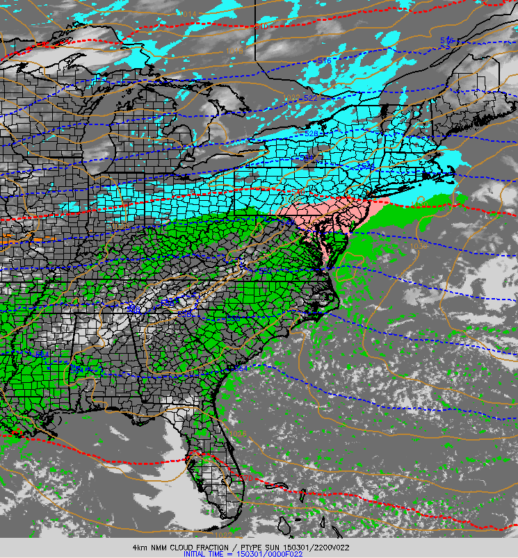
Quick update this evening on our light snow event that is beginning across the region currently and will continue through early tomorrow morning. Light snow is beginning across southern and western areas right now and will continue to spread east this evening. Since the atmosphere is quite dry at the moment, expect some of the radar returns shown below to not be making it all the way to the ground.
Expect snow to continue through the night tonight before ending early tomorrow morning. Clearing skies can be expected tomorrow along with NW winds and cooler temps. Details on tomorrow’s forecast will come in tomorrow morning’s forecast update.
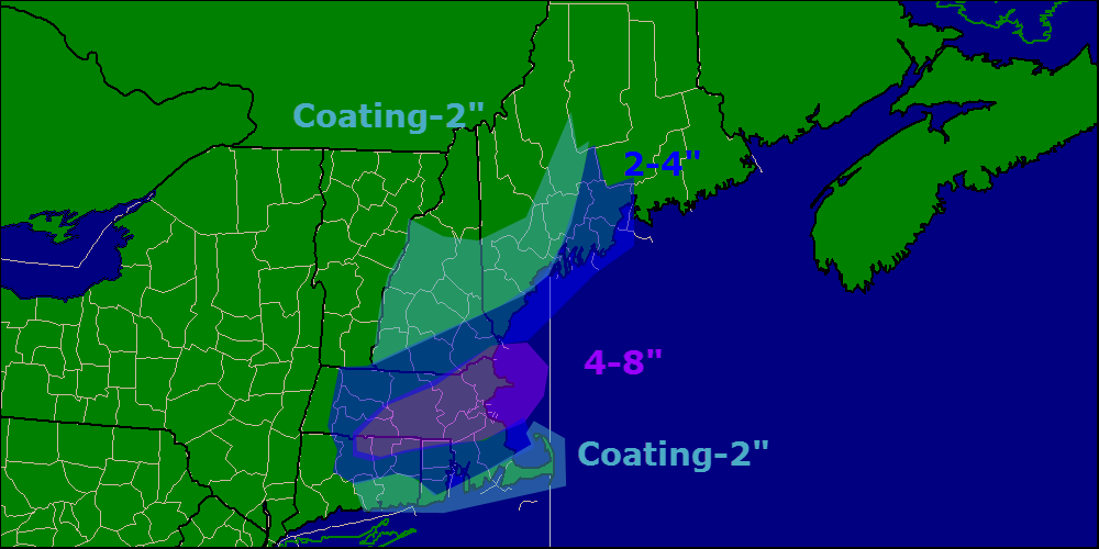
Just a few minor changes to the snow map this evening, highest snow totals look to be south and east with this one yet again. Another storm heads our way midweek with a warmup too.
Happy meteorological spring!!* Today will feature increasing clouds in the morning followed by clouds and increasing snow in the afternoon/evening hours. Expect all areas to see clouds by around 9 this morning while snow should wait until after 3 this afternoon.
Temps this morning are anywhere from the 10s below zero to single digits above zero warmest where light breezes still blow. Check out yesterday’s post for an explanation on why that is. Temps will rebound quite well today into the lower 20’s north and higher 20’s south.
NAM Model Showing Precip Moving Into The Area At 5 This Evening
Total snow accumulation thoughts have not changed much since last night and it still looks like the Boston area will pick up the most snow. Last night’s snow accumulation map still represents what I think will pan out in terms of total snowfall.
Another batch of precip arrives Wednesday, more details later.
-Jack
*Rules and restrictions apply, see Florida for details 🙂
Special update this evening to bring you up to date on yet another storm that will graze us with some light snow tomorrow night into Monday morning. This storm will, like many this winter, develop in such a way that eastern areas as well as southern areas will see the most snow.
12Z GFS Showing The Storm To The NE And The Moisture To The SE At 7 AM Monday Morning. Credit: Weatherbell
As we have seen many times this winter, the storm will be developing too late to bring significant snowfall to the region however, with snow just coming to an end across coastal areas Monday morning, the commute will likely be slick. Snow moves out during the midmorning hours Monday before clearing takes place Monday afternoon.
Here are my thoughts regarding snow accumulations. The Boston area looks to be the jackpot yet again while northern areas miss out.
Another snow event looks to arrive on Wednesday and may involve some mixed precipitation for southern areas. More details later.
Snow is currently in progress over areas NE of Portland with the heaviest precip centered to the east of Brunswick. Expect light to moderate snow to end before dawn for areas to the west of Bath with snow sticking around through around 9 AM for areas to the east of there.
After snow moves out this morning, NW winds will take over and we will begin the upslope/downslope cycle where the mountains squeeze out the moisture in the air causing clouds and flurries while the foothills/coast sees all the remnant dry air and thus clearing. The moral of the story – mountain clouds/flurries, coastal sun. Temps will be in the 20’s for most with some 30 degree readings possible along the coast.
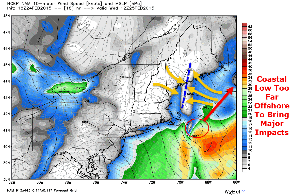
Special update this evening to cover another Norlun trough type setup that looks to bring another round of light snow tonight and into early tomorrow morning. While the heavy snow bands usually associated with Norlun troughs will remain mostly offshore, an axis of shifting winds with reasonably impressive instability and some lift too will make an appearance mainly east of Brunswick tonight into tomorrow morning.
18Z NAM Showing A Distinct Wind Shift Line (Orange Arrows/Blue Dashed Line) Over Midcoast Maine At 7 AM Tomorrow. Credit: Weatherbell
A low pressure area that brought snow and ice to the southeast US will move too far offshore to bring major impacts though a Norlun trough, basically a wind shift line, will extend to the NW of the storm bringing coastal areas some snow. Snow will be concentrated between 11 tonight and 9 tomorrow morning.
12Z GFS Showing Intense Upward Motion Over Midcoast Maine At 7 AM Tomorrow. Credit: Accuweather
While snow will mainly be light, especially west of Brunswick, some moderate to even heavy bursts of snow are likely across Midcoast areas. The map above shows intense upward motion across Midcoast areas tomorrow morning signaling bands of heavy precip are possible. The areas most at risk for heavy precip will be east of the Bath/Brunswick area.
Here is the expected snowfall from this event. Not a lot, but the driveway will once again have to be cleared especially over eastern areas.
@SurfSkiWxMan@capecodweather , it's a hybrid NORLUN.. impressive lift/instability..no question there will be +SN, question is for how long?
In case you were wondering if this event was a Norlun trough, Weir Lundstedt, one of the two ‘discoverers’ of the Norlun trough (he represents the ‘lun’ part of Norlun) confirmed yesterday evening this did in fact look to be a hybrid Norlun event.
It’s really cold out this morning. No, really cold. Temps everywhere are below zero, even at the coast. Most areas, except for the outer islands and peninsulas are in the double digits below zero and 20 below is not uncommon region wide this morning. The good news is that the wind has died down so at least we won’t have to worry too much about wind chill. Regardless, bundle up if you must venture out this morning.
Temps will continue to drop until a little after 7 and will then rise swiftly as the high sun angle contributes to more effective heating. Some mid and upper level clouds will move in this afternoon and some coastal areas could see a low cloud deck move in as well later in the day but otherwise, another bright and blue one region wide today.
One interesting little note on our temp map this morning (off NWS’s Enhanced Data Display) are the numerous, very sharp inversions. Inversions are very shallow warm layers that basically lock away patches of air at the surface and temporarily prevent them from being influenced by the rest of the atmosphere. There are several great examples of that this morning.
Wiscasset (the -21 reading in the red circle) sits at an elevation of 53 feet while Nobleboro (the -9 reading in the red circle) sits at 126 feet. While they aren’t far apart (just 10 miles) and aren’t drastically different in elevation (a mere 73 feet), the subtle differences of their locations and especially elevations have made an enormous difference in their temps this morning. Go up in elevation just a little bit and you may find it’s quite a bit warmer this morning.
More snow is coming in tomorrow though it will be mainly light. More details in posts to come.