Today will feature mainly cloudy skies, cold temps, high winds, and snow as winter finally shows up in a real capacity at least for a couple days. Look for highs today to struggle into the single digits above zero north and the 10’s south late morning before dropping below zero area-wide tonight. Lows tonight will be dangerously cold with actual temps of 15 to 25 below north and 5 to 15 below south teaming up with 25mph NW winds to create downright dangerous wind chills. Wind chills in the mountains will range from -30 to -50 (colder at elevation, the summits above 4,000 feet willl see even more extreme wind chills) while the coast and foothills see wind chills ranging from -20 to -40.
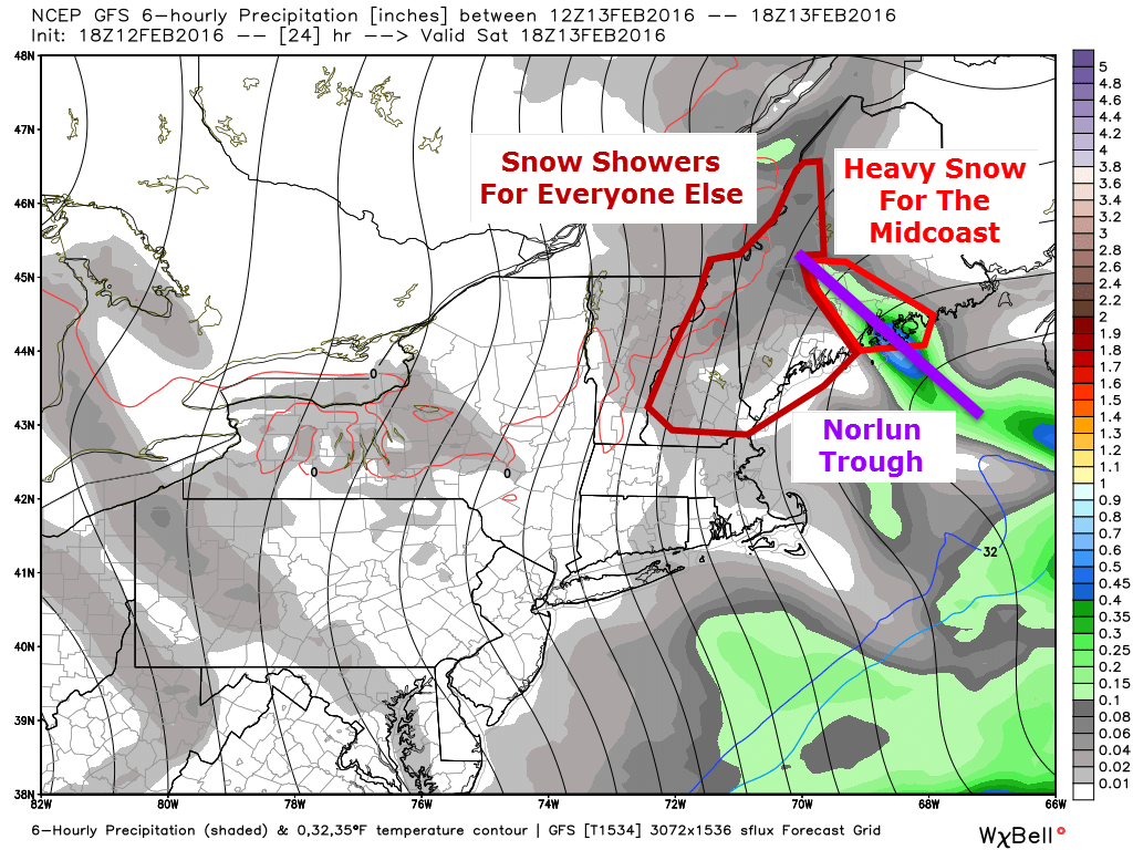
Across the midcoast, things get really interesting today as a Norlun trough develops. 6-10″ of snow is likely wherever it sets up and thumps though it remains to be seen exactly where that is. I went into detail about the forecast and also about how Norlun troughs work in my blog post last evening which includes my snowfall forecast. Farther west, snow showers and flurries are possible today but accumulation will remain under an inch with the exception of the mountains where a few inches of upslope are possible.
I’ll have more updates on the cold tonight and a messy storm threat for midweek this evening.
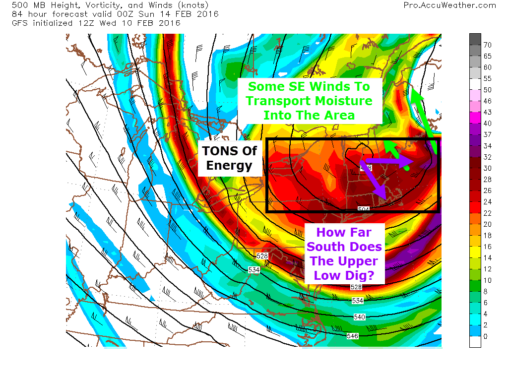
Cold air is firmly entrenched today but even colder air is on the way. Look for a cold front to smash SE tonight bringing behind it the coldest air all season and the first truly Arctic air we’ve seen all season. As the cold air moves in, an upper low diving to our south will set the stage for a Norlun trough event along the midcoast tomorrow. Beyond that, bitter and dangerous cold arrives Sunday followed by a messy storm midweek next week.
Saturday Norlun Trough
12Z GFS Showing The Setup For Tomorrow. Image Credit: Weatherbell
The front gets hung up along the midcoast as the upper low slides to our south. Winds out ahead of the 500mb trough will turn southeasterly and eventually easterly which will provide a mechanism for moisture to be transported into the region. Also, with southeasterly winds aloft, there will be nothing to move the trough once it sets up. Most of us will see the moisture transport aloft in the form of light snow/snow showers during the day tomorrow with light accumulations. The midcoast will be the only area to really capitalize on that. To understand why, read the next paragraph about how Norlun troughs work. If you’re more interested in the forecast, skip on down to the next picture and read about the cold coming Sunday.
A Look Behind The Scenes At Norlun Troughs
Here is a graphical explanation of a Norlun trough I did for UpPortland. Notice that tomorrow the trough will be over the Midcoast rather than Portland. All rough image design credit goes to me (and Frontpainter for the map)
Because it’s been so warm recently, the ocean is still quite toasty. This sets up a very large difference in temperature between the warm ocean and the cold air. The warm water will heat the lowest level of the atmosphere creating warm air which wants to rise. Above this very shallow layer of relative warmth lies an entire atmosphere of very cold air which wants to sink. Somewhere in the impenetrable fortress of cold, there will be a weakness. The warm air will rush upwards through this weakness generating tremendous upward motion and leading to warm moist air crashing into cold dry air. This violent collision will produce snow.
A Cross Section Of The Atmosphere Showing The Dynamics Involved With The Trough. More Rough Image Design By Me.
As the new trough takes up the energy immediately near it, warm air trapped under the cold air all across the Gulf of Maine will rush in to take its place so it too can rush upwards and cool. As the trough is using up the existing warm air, new warm air will keep being created as the water continues to warm the lowest levels. This warm air will rush to the weakness in the cold and rise up, depositing its moisture along the way. This is what we call a Norlun trough.
One of those will form over the midcoast and deposit heavy snow tomorrow. Totals are likely to come it at around a foot in the core of the trough but it remains to be seen exactly where that sets up. These events are notoriously fickle and can set up wherever they please or not at all. One good example happened just last night when a weak Norlun formed over Portland out of left field causing major issues. Bottom line: expect the unexpected.
Expected Snowfall. Notice The Sharp Cutoff Which Leads To High Uncertainty From Brunswick On East To Rockport.
Expected snowfall for tomorrow. Upslope snow showers in the mountains are likely to produce 1-3″ in the usual spots. Farther south, a dusting to as much as 2″ is possible with isolated snow showers/flurries. In the core of the Norlun, thundersnow is possible as there will be a solid amount of instability associated with the temperature falling dramatically with height from the warm ocean to the bitter cold air moving in aloft (technical: lapse rates will be very impressive).
NW winds will be howling tomorrow beginning in the afternoon. While blowing and drifting snow will initially not be an issue, by Saturday night, those who saw snow will also see it blowing around leading to more slick spots and reduced visibility. It will also add an extra sting to the air if you happen to be out and about Saturday night.
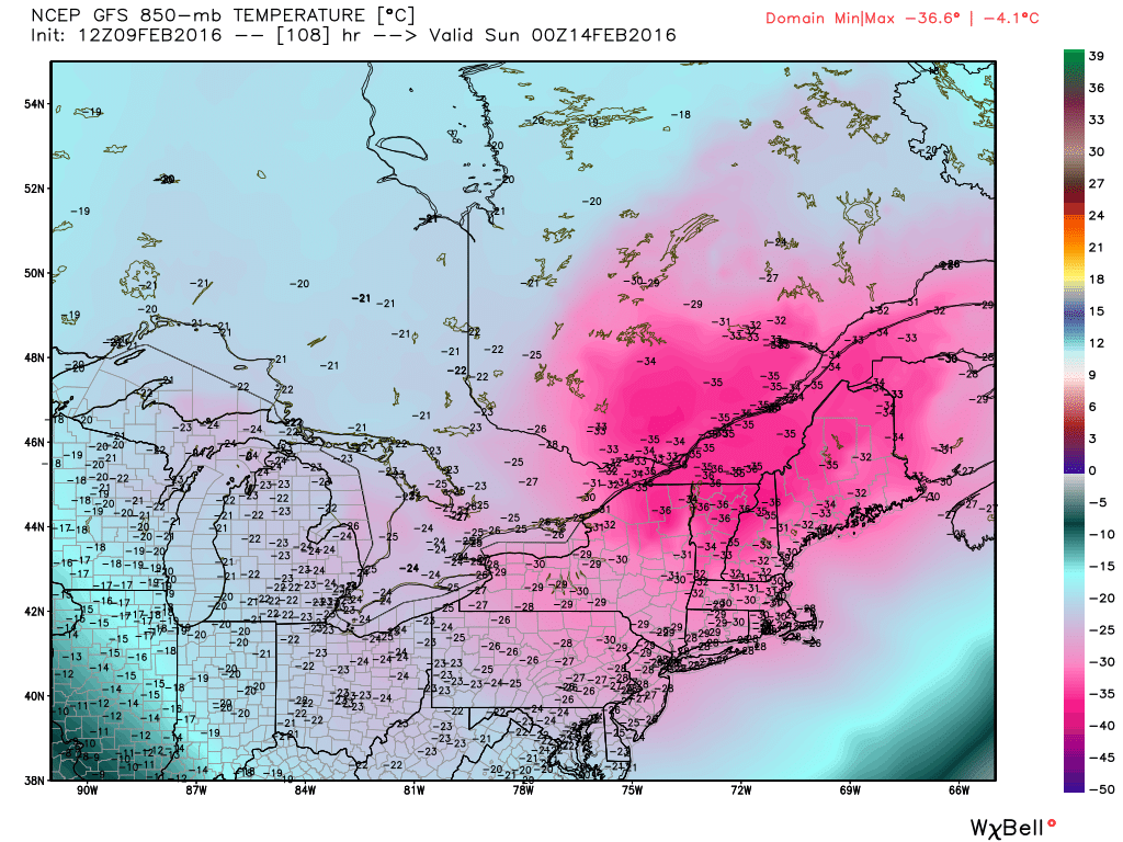
Very cold air is still on track to come into the area behind the storm on Sunday. Actual temps will drop well below zero and as NW winds howl at over 25 mph, wind chills will drop even lower. This is the image I used for last night’s post and it still applies as wind chills approach -40 to -50 in the north with -20 to -30 degree wind chills in the south. Bundle up for the Valentines Day dates both Saturday and Sunday nights. Thankfully, the extreme cold is out on Monday.
Messy Midweek Storm
12Z GEFS Showing The Range Of Possible Outcomes And The Lack Of Confidence Regarding The Forecast At This Point. Image Credit: Weatherbell
As the cold retreats, we have another storm threat. We are virtually certain to see precip the question is of what variety. Right now, it looks like a mess with all precip types possible for everyone. It is far too early to nail down exact impacts or amounts but total accumulation of whatever falls could be significant. My thinking from yesterday still applies in that uncertainty remains large here. One group of forecast models leans towards a colder, farther east solution with more snow than mix while another camp of models leans towards more rain and mix than snow.
Another storm is on the horizon late next week but we have to get the first two resolved before we can dig into that one. Just know that there is the potential for a storm and as always, ignore any hype you may see.
I’ll have more updates in the coming days as the midweek storm becomes clearer. I’ll also be on Twitter watching the Norlun trough evolve tomorrow @JackSillin.
Today will feature a mainly sunny start with fairly mild temps as cold front number one clears the coast, removing the moisture from last night (not that there was that much of it). Cold front number two blasts south today bringing the chance for heavy snow in the form of snow showers and squalls. A coating to as much as 2″ of accumulation is possible where these squalls form.
HRRR Model Giving A General Idea Of What To Expect In Terms Of Squally Weather This Afternoon. Credit: Weatherbell
Here is the general idea of how things play out this afternoon. Don’t take this too literally in terms of exactly who gets a burst of snow but know it’s definitely possible especially in southern areas. Heavy snow could briefly cause low visibility and slick up roads for the evening commute.
Another update this evening looking at a bitter cold blast this weekend which will be bookended on either side by snow threats. Let’s start with the snow threat on the front end of the cold air which arrives Saturday.
Saturday’s storm threat really hinges on how far south an upper low digs and how fast its attendant surface low develops. Right now, Downeast areas look best in terms of everything pulling together in time for a sizeable snow event. Here in Western Maine, I think this is more of a one and done blast where a quick several inches are likely to fall. The timing on this would be later in the day on Saturday though the details are still to be ironed out.
The core of the bitter cold arrives Sunday with dangerously cold temps on the order of lows around 20 below in the north, 10 below in the south. Highs likely don’t make it to 0 in the mountains on Sunday while the coast struggles to 10 above. Wind chills will remain in the -40 to -20 range region wide Saturday night into Sunday. Yeah, this is the real deal.
Next Week Storm Chance
Yesterday’s 12Z GEFS Showing The Threat For A Snow Event Next Week. Credit: Weatherbell
As the coldest of the cold retreats early next week, the door is open for more snow. My thoughts on the threat remain unchanged from Yesterday and current solutions range from ice/rain to out to sea. Here’s the graphic I posted yesterday evening that shows the spread as well as which scenario has the most credibility as of now (the snowstorm scenario). This is still a while away so things will definitely change. Be sure to stay updated as to the latest forecasts.
I thought I’d take a minute this evening to go over the next week or so of weather taking a quick look at what to expect. This will be a tale of a classic New England winter with snow, bitter cold, and the potential for a sizeable storm. Let’s start with the light snow which arrives tomorrow.
A storm will pass well offshore tomorrow but an upper low still lurks to our west. Much like with our last storm, there will be a moisture transfer between the two storms. However, both storms will be weaker this time around especially the offshore storm (weak wave compared to powerful bomb). Therefore, the same concept applies but with less snow. Spotty snow showers will impact most but they will be hit or miss. The midcoast could get brushed with a bit of steadier light snow. A coating-2″ is forecast for everyone but 3″ is possible in the mountains and along the midcoast.
Bitter Cold For Valentines Day
12Z GFS Showing VERY Cold Air Over The Region Sunday. Credit: Weatherbell
An Arctic front blasts south Saturday and frigid winds bring in very cold air behind it. Lows Sunday morning are likely to drop well below zero into the 20’s below up north and the 10’s below in the south. The map shows temps at 5,000 feet so don’t panic with the -30C temps across Maine but do realize this is the real deal with dangerous cold on Sunday. Highs on Sunday will struggle to get above zero across Maine and New Hampshire and probably won’t in the mountains. The coldest air arrives just in time for Valentines Day so plan accordingly. Thankfully, the brutal cold moves on heading into next week though it does leave us a parting gift in the form of a storm threat.
Snow Threat Returns Next Week
12Z GEFS Showing The Threat For A Snow Event Next Week
As the bitter cold retreats, a storm will likely try to form somewhere. At this point, all solutions are on the table from Rain to OTS though the general consensus is for some type of snow event. This is too far out for specifics but just know that at some point in the middle of next week, there could be a snow event.
Snow is currently falling across the region with light to moderate being the dominant intensity. Look for this to continue through the night along with high winds that will blow the snow into a low visibility, drift inducing frenzy. Amounts in your front yard will range from 0-24″ when drifts are included. The actual amount of snow that will fall from the sky is likely to be in the 4-8″ range along the coast and in the 2-4″ range inland though with drifts, amounts will be far different when you look outside tomorrow morning.
HRRR Model Showing The Evolution Of Light Snow Tonight Through Early Tomorrow Morning. Credit: Weatherbell.
Here is the HRRR model with a general idea on the evolution of the snow through tomorrow morning. I suspect it may be a little quick to shut off the snow as the upper low to our west will be eager to continue pulling in moisture. I think mid to late morning is a more reasonable stop time with drying from SW to NE.
Snowfall amounts from last night still look good with 4-8″ for most, 2-4″ in the mountains.
Snow showers are possible throughout the week as waves of low pressure develop well offshore. Another chance for respectable snow arrives early in the weekend next weekend followed by a blast of truly Arctic air early next week.
Everything is lining up as forecast and a long duration light snow event is likely today. Snow looks to arrive around noon here in Maine, a little earlier along the coast, and a little later inland towards the mountains. Not much has changed since yesterday in terms of expected snowfall. I still think the coast has the best shot at hefty snowfall amounts. Keep in mind, snow will be able to accumulate quite efficiently despite snow never falling that heavily. The good news with the light snow is that it will be easily moved by your shovel. The bad news is that it will be equally easily moved by the strong winds today that will gust along the coast to near or over 30mph. As a result, expect blowing and drifting of the snow not only that is just falling, but also of the 6″+ of snowpack most coastal areas have left over from Friday’s storm. This is likely to cause visibility issues especially for the evening commute.
HRRR Model Showing Heavy Snow Remaining South But Light Snow Impacting Maine Today. Credit: Weatherbell
Here is the HRRR model just to give you an idea of how the storm plays out in general. Don’t take it word for word in terms of individual bands or timing down to 15 minutes but look at it to get the general idea of the heavy stuff remaining south and the light stuff sitting over us for a while.
Temps today will be in the 10’s and 20’s.
Snow winds down tomorrow afternoon though snow showers will continue through Thursday as various pieces of energy rotate around an upper trough to our west.
After a nice little storm today, we turn sunnier and cooler tomorrow as low pressure moves east. Another low is already developing in the Gulf of Mexico and will be moving offshore well to our SE Monday. Normally, this would be a slam dunk miss but a strong upper low will be driving SE and there’s a lot of energy on the leading edge. Surface low pressure will develop over the Great Lakes in response to the upper low and a surface trough will develop between the Great Lakes low and the offshore low. This sets up a tricky forecast for Monday as this trough could take on some Norlun traits leading to narrow and possibly heavy snow bands.
12Z GFS Showing A Very Favorable Setup For A Norlun Event. Image Credit: Accuweather
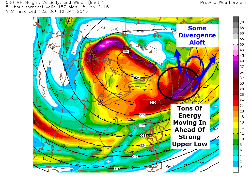
Looking at the 500mb setup, there are a lot of things going for a Norlun event. A strong upper low is moving in from the NW and on the leading edge, a strong peice of energy is moving right over us. Also, being ahead of the upper low, the flow aloft is divergent. To put this in simpler terms, the air at 20,000 feet is spreading out. This leaves a void that air from below must rise to fill. Think of what happens when you pull your hands apart on the surface of a lake or bath. Water rises to replace the water you pushed to the side. This rising motion helps generate precip. This is how everyone will see a coating to an inch or two of snow tomorrow night into Monday morning. The real fun is along the southern coast with a Norlun trough.
At the surface a storm will blast by well SE tomorrow. Another weak wave will develop over the great lakes. The link between the two will manifest itself in the form of a Norlun trough extending NW-SE across the area. Everyone sees light snow from synoptic (large) scale divergence aloft but any moderate snow amounts will be dominated by a mesoscale (small) norlun trough. These troughs generate narrow, heavy snow bands (think lake effect type) that can drop moderate to heavy accumulations in one town while the next town over sees some flurries and maybe a coating. My point here is that uncertainty is quite high.
Graphic Showing How A Low Forms Off The Maine Coast With Strong West Winds. Credit: Me
Another thing to watch out for with Norlun type events is the threat for a mesolow to develop. Mesolows are caused by rising air along and near the trough and also westerly winds accelerating and veering as they move from a high friction environment (over land) into a low friction environment (over water). Imagine the right front tire of your car running into a patch of ice. As that tire moves from a high friction environment (pavement) into a low friction environment (ice) it accelerates while the left front tire is stuck on the high friction pavement and can’t move as fast. The result is your car spinning out. The same thing happens with air moving from over land to over water. Above I’ve drawn up a quick graphic showing how west winds and a cold airmass emerging over water can generate a low. The divergence aloft and strong upper energy aids in this process. This doesn’t happen behind every cold front because often the air is and sinking. The air monday will be rising due to the approaching upper low/divergence which will help with the development of the low.
12Z CMC Showing The Potential For A Mesolow Along The Coast Monday Afternoon. Credit: Weatherbell
The 12Z CMC shows this potential well. Should this occur, most of the coast could see a moderate snowfall and amounts would be slightly less dependant on the fickle Norlun. While most models don’t show this, based on warm waters (still over 40 degrees!), rising air ahead of the upper low, the strong energy aloft, and the movement of the surface airmass, I think there is a good chance some sort of mesolow develops and strengthens tomorrow afternoon.
Here are my thoughts for snow. This is tentative as Norlun troughs are notoriously fickle. I’ll have another update tomorrow morning.
My apologies on this post for an uncertain snow event going out so late and being so short, cramming in something that usually takes 4+ hours into 2 is hard. With that aside, I’ll do my very best to look at the forecast for tomorrow night in some detail below.
Overview
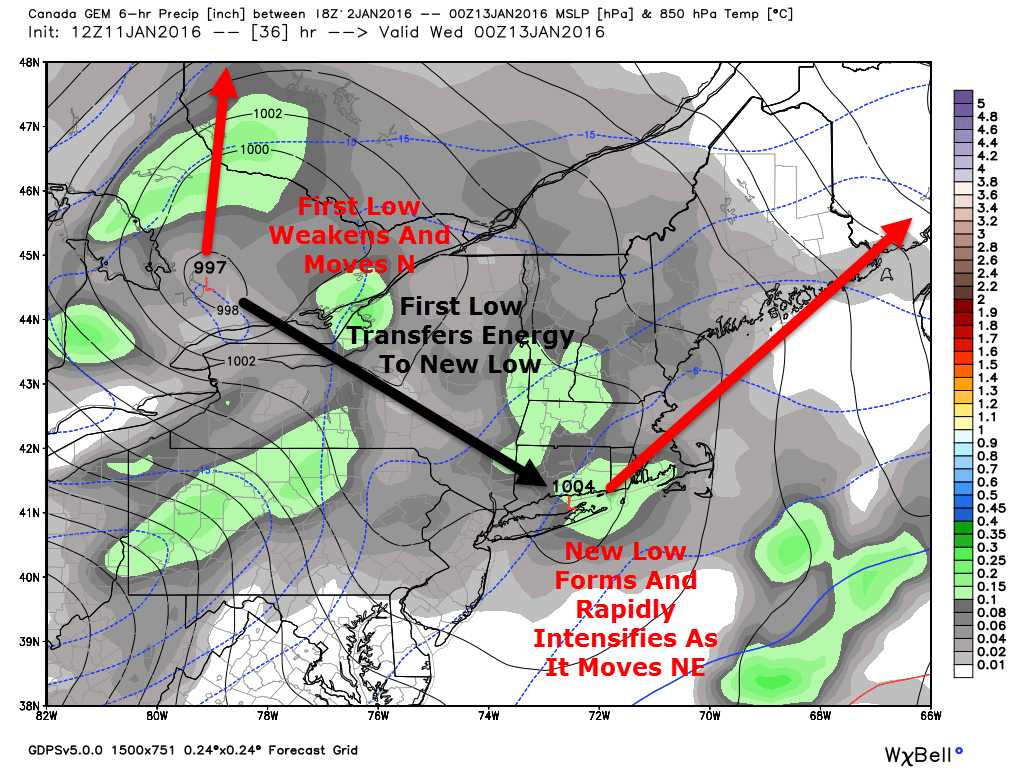
12Z GEM Showing The Setup Tuesday Evening. Image Credit: Weatherbell
A clipper system is currently moving across Minnesota and will continue to dive SE tonight into tomorrow morning. It will end up over the Eastern Great Lakes by tomorrow afternoon. At this time, a new low will form near NYC/Long Island and move NE as it strengthens. The key to this forecast and why it is so uncertain is how fast this low intensifies. I want to stress that the difference between a widespread 3-6″ and a widespread 8-12″ event is a few hours. If the storm forms a bit earlier, there is more snow. If it is a bit late, there is less snow. Either way, a burst of heavy snow is likely tomorrow evening around or a little after the evening commute. Overall, impacts should be minor but after 7 or 8 tomorrow evening, roads are likely to become quite slick.
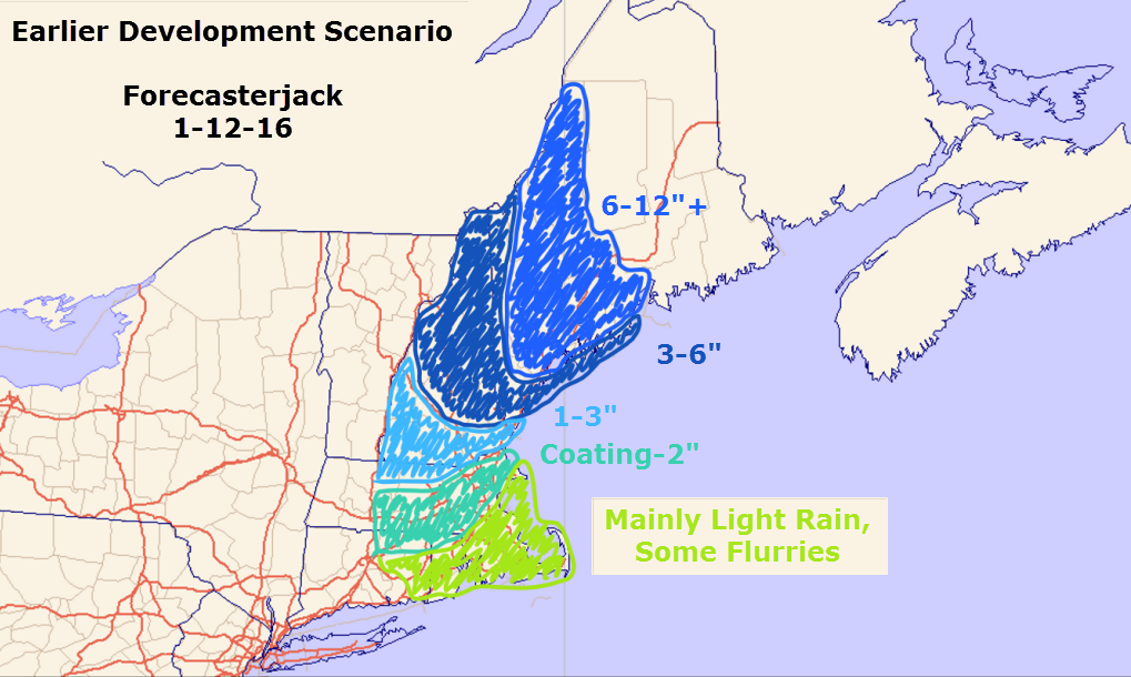
The Earlier Development Scenario
12Z GEM Showing Intense Upward Motion Leading To Very Heavy Snow Over Western Maine Tomorrow Night. Notice The Position Of The Red (Very Heavy Snow) Over Western Areas. Credit: Accuweather
This is the GEM model showing the earlier development scenario. At 11PM tomorrow night, an intense band of very heavy snow is located over Western Maine centered on a Portland-Lewiston line. In this scenario, intense snow bands develop earlier and farther to the west leading to higher totals across SW areas. Based on very warm SST’s offshore and the very high amount of energy blasting SE with the clipper, I think this is the more likely scenario. The 500mb trough will also be going sharply negative.
12Z GEM Showing The 500mb Factors In Favor Of Explosive Storm Development. Image Credit: Accuweather
A very negative trough with a ton of energy blasting over record warm ocean temps is a setup ripe for explosive storm development. The 12Z GEM shows this well. The other models show a similar setup and the GEM has shown itself to be very reliable when dealing with clippers and Canadian airmasses. It was the one model that caught the surprise no-show of the February 15 blizzard and I think it is on to something in terms of surprises with this storm.
This is what snow totals would look like if the low developed on the early side. Consider this my forecast.
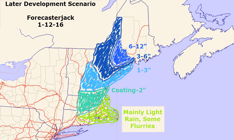
The Late Development Scenario
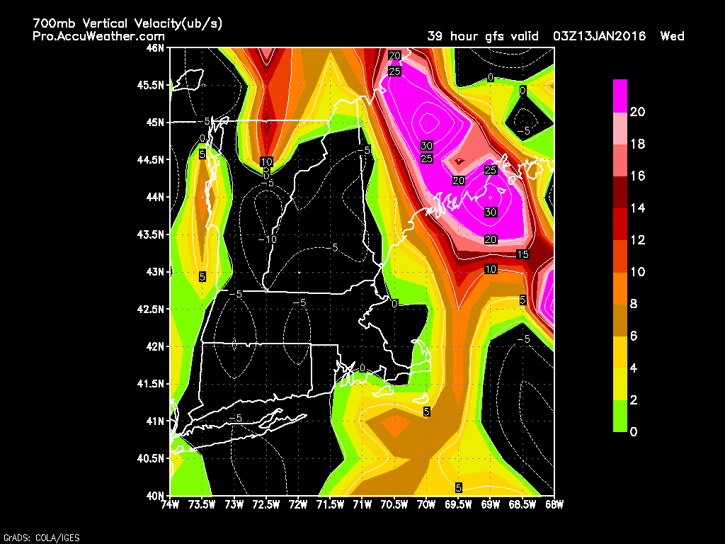
12Z GFS Showing Snow Bands Firing Up More Along The Midcoast Than The ME-NH Border. Credit: Accuweather
It is also entirely possible things don’t pull together in time and the heavy snow bands really get going more over the eastern Midcoast than the NH-ME line. The GFS shows this well. This is the same parameter (upward motion) for the same time as the GEM map posted above. Compare them and look at how much farther NE the heavy snow bands (bright colors) are on the GFS compared to the GEM. This is the difference between 3″ and 8″ for most areas SW of Augusta. Where these snow bands set up is the entire forecast at this point. It is important to note that the GFS shows nearly the same 500mb setup. The trough on the GFS is the exact same as on the GEM with the only difference being the GFS is 30 or so miles farther NE. That is the difference between 3″ and 8″. I really want to stress how tiny the differences are in terms of the science. 30 miles is a tiny margin of error, it just so happens that this time that margin of error has tremendous impacts for a large swath of the area. Be prepared for either scenario despite the forecast being for more snow.
This is what snow totals would likely look like given the late development scenario playing out. This is not what I expect to happen but it remains a viable solution. In fact, new clues have emerged since the making of this map that indicate that totals could be slightly less than this if the low really fails to get going. Don’t be shocked if you wake up Wednesday to only a few inches SW of Augusta. Several inches look like a safe bet for the Midcoast and the NE mountains.
Coastal Mixing Concerns
12Z GEM Showing Near Freezing Temps At The Coast. Credit: Weatherbell
Winds ahead of the clipper will be onshore and thus temps will be marginal at the coast. However, winds will turn N/NE as the coastal low develops which will act to shut off the source of warm air. Also, heavy precip acts to cool the air and precip will certainly be heavy tomorrow night. All added up, I think this will be a wet snow for most coastal areas with only the peninsulas seeing rain. Again, this part of the forecast depends on the coastal low. The faster the low develops the faster cold air rushes in.
This is a VERY uncertain forecast so I’ll try to have an in-depth update tomorrow morning with details. I’ll have another update tomorrow evening as the storm is beginning. At this point, the details will be more clear (helpful, I know!).
Most of the heavy snow and sleet is off to our NE now as the mid levels dry out. Despite a lack of heavy precip, snow and sleet will still remain across the area this evening with another inch or so of snow and a coating of sleet and possibly a glaze of freezing rain as well. This continued light precip will cause roads to remain slick through the next few hours so continue to use caution if travelling.
Seeing as the storm is winding down, this will be my last update today. I’ll be back tomorrow morning with a look at tomorrow’s weather.
-Jack
10:30 AM Update
Heavy snow and sleet is ongoing across the region currently although the worst of the worst is now mainly NE of Portland. I expect moderate to heavy snow and sleet to continue for the next few hours with the worst gradually sliding NE. This afternoon, look for the second phase of the storm which is already beginning across southern areas which includes lighter mixed precip.
In Yarmouth, what I’ve been seeing generally seems to match up with other reports I’m seeing on mPING and on Twitter from folks across southern areas. Snow has been heavy here and is mixing with sleet. The sleet is piling up though, I’ve gotten about an inch of sleet on top of 4.5″ of snow as of 10:30. Keep in mind everything is still quite slick out there so use caution if traveling!
-Jack
7:45 AM Update
Snow continues across the region this morning. Here in Yarmouth, there was a period of sleet around 7 but the precip has since turned back to all snow as heavier precip moved in. As of 7:45, the precip remains all snow with very efficient accumulation. Due to cold temps around the area (10’s for most, 20’s coastal York county), the snow is dry and fluffy. I suggest shoveling/snowblowing now before the sleet turns the snow into frozen cement. Snow and sleet will continue with sleet moving north east through the morning. It seems that a middle of the road solution is playing out across areas north of York County with snow during times of heavy precip and sleet when precip is lighter. This will continue through the morning.
There are reports of many accidents across the are this morning and roads are very slick especially if your area is seeing sleet. Use extra caution on the roads today if you must travel. Also, remember to use your mPING app today! There has already been tons of great data flowing in and it’s really helping with the forecast!
-Jack
Original 6:15 AM Update
Hello everyone!
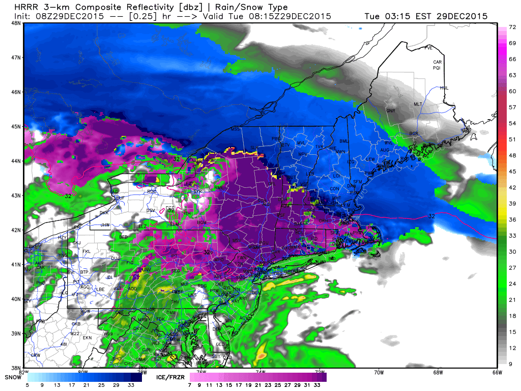
Today will feature a messy winter storm as low pressure moves through the Great Lakes. Warm air will be rising up and over a well-defined cold pool at the surface. This is the lifting that will produce moderate to heavy precip today. I’ve been digging into the depths of the forecast the past few evenings and now it’s time to bring it all together.
Morning Snow
HRRR Model IDEA On How Precip Unfolds This Morning. Keep In Mind This Appears To Be On The Cooler Side Of The Solutions. Credit: Weatherbell
Snow is falling across northern parts of New England this morning. Sleet has mixed in as far north as Manchester, NH as well indicating a warm layer already developing aloft. There are two possible solutions with this morning’s snowfall. Our first option is that the sleet line progresses as it has in the past hour unimpeded in its relentless march NE. This would result in sleet arriving during the heaviest of the precip, several hours earlier than last night’s forecast. Should this occur, look for totals lower or just under the lower end of the range from last night’s map (re-posted below). The other idea (this is the one you see above with the HRRR) is that the precip is so heavy that it dynamically cools the atmosphere. This has to do with the displacement of mass and is a topic for another day but the point is that if this occurs, the mid levels of the atmosphere could cool enough to allow for a little more precip to fall as snow thus resulting in totals more towards the middle or even upper end of the total ranges. Be prepared for either of these solutions. Remember even though it accumulates more slowly, sleet is icier and more slippery than snow. It is harder to drive in. Take it slow out there this morning.
Lingering Precip This Afternoon
After the initial burst of snow comes through this morning, precip will shift to a lighter more spotty type. This will fall any number of ways depending on your location. A mix of snow, sleet, and freezing rain is likely across the south with snow and sleet farther north and all snow up in the mountains. The freezing rain expected across the south will continue to cause very slick roads. Slick travel is expected everywhere today but in terms of a complete lack of traction, nothing beats .1-.3″ of ice on top of an inch or two of sleet on top of 4-6″ of snow.
Help Forecasters Track The Storm!
Given the plethora of precip types incoming with this storm, tomorrow would be a great time to give the mPING app a workout! Over the past few days you’ve seen how hard it is to forecast multiple precip types. Here’s a chance for you to help forecasters out! Simply download the free app and take a look outside! Send in your report of snow, sleet, freezing rain, or rain and you can help forecasters like me with forecasting multiple precip type events! The data is sent to the National Severe Storms Laboratory to help with radar development which gives models better data which improves forecasts. Read all about it over on the NSSL webpage. Also through that website, you can view your report and everyone else’s reports to track the rain/snow/sleet line in real-time! This is one of my most valuable tools for tracking the mix line to verify the forecast/make adjustments if needed. Happy reporting!
Totals
Forecast Total Snow/Ice Through Tuesday Night
I keep my map the same this morning as I think each solution (warm or cold) is equally likely. There are interesting radar trends that indicate the colder solution is playing out though you can’t go against hurricane force winds 10,000 feet up blasting in warm air.
Live Blog
We’ll know more as the morning goes on and I’ll keep updating this post as I see changes happening. Keep checking back right here through the morning and I’ll have new info at the top of the page as it comes in. I will also be on twitter with updates all morning @JackSillin.
Here is the link to last night’s post as the information there more or less remains the same.