Today will feature mountain clouds and coastal/inland sun as west/northwest winds create a downsloping pattern. Some sprinkles or flurries are possible in the mountains as well. Highs will range from the upper 30’s to low 40’s north to the low to mid 40’s south.
Today will feature rapid development of low pressure to our east. Usually this means we get some sort of large storm but that will remain in the far northern mountains where a few inches of snow is expected. The rest of the mountains are likely to see lesser accumulations in the 1-3″ range and a dusting is possible in the higher elevations of the northern foothills. Farther south, a few rain showers could stray to the coast from time to time but steady precip is unlikely. Temps will be falling beginning with temps currently in the mid to upper 30’s north and low 40’s south. The temps this morning will be pretty close to the high temps today as cold air moves in on NW winds which will be pretty busy with gusts over 25-30mph at times.
Snow departs tonight and leaves only moderately cold air as El-Nino continues to lock up truly arctic air thousands of miles to our north.
Looking ahead, we appear to have a solid week or more of cloud watching ahead. Enjoy, winter haters, but remember, cold and snow will rise again.
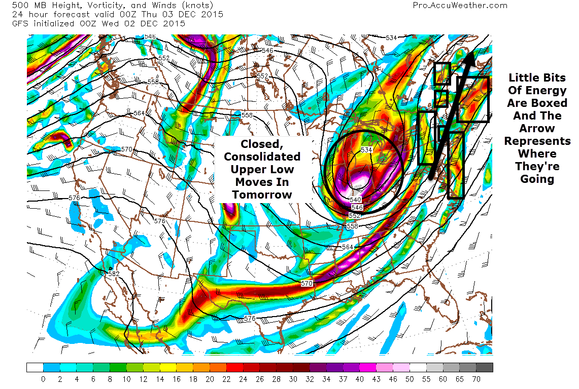
An upper level low is approaching from the west this morning and out ahead of it is a stream of little bits of energy. As each little bit of energy moves through, showers are expected. Because the energy is not concentrated in one system, the rain will be on and off through the day today as various weak storms move around the area.
12Z GFS Showing A Stream Of Weak, Disorganized Energy Ahead Of An Upper Low. Map Credit: Accuweather, Annotations By Me
The map at right shows what I’m talking about in terms of the disorganized bits of energy. The scale at the bottom shows how much energy is in the air and as you can see, the energy out ahead of the upper low is pretty weak and not concentrated in one area (lots of yellows/oranges instead of purples and whites) like the energy in the low is. Because of this, the surface maps look pretty similar with a bunch of little storms rather than one big storm. As you can imagine, the radar probably won’t look too much different either with small moderate batches of rain rather than one single heavy rain shield. Therefore, rain will be hit or miss today.
The HRRR model’s simulated radar product (above) helps to visualize this as wave after wave of light to moderate rain rotates through. Animation credit goes to Weatherbell.
I should also note that temps this morning are still around freezing in isolated pockets up north and freezing rain could still be an issue for a few more hours. The NWS has put out a Freezing Rain Advisory for that threat so if you’re traveling in that direction watch for some slick spots.
Temps today will range from the mid to upper 30’s north to the mid 40’s south.
The upper low finally gets close enough to the coast to form a new storm that will once and for all consolidate the disorganized mess of energy that is today’s rain tomorrow and with it up to 6″ of snow is possible for the northern mountains. I’ll have more on that tomorrow morning but figured I’d put it out there today so it wouldn’t be a surprise.
Again, I hope to be able to have an update this evening but am at the mercy of other high school commitments.
A semi tricky forecast this morning as warm air moves north bringing with it rain, eventually. The tough part involves just when that rain will arrive. It looks like most areas should expect raindrops by late evening in the 6-8PM range however don’t be surprised if a few sprinkles pop up here or there before that as warm air continues to climb up and over the very cold airmass in place.
This cold airmass will cede its control over to the warm air in most places south of the mountains but in the valleys, the cold air will remain in control and thus a period of freezing rain is likely tonight and the NWS put out a Freezing Rain Advisory for the mountains because of that.
Rain and freezing rain continue into tomorrow at which point the precip becomes more showery before a secondary low moves in and restarts precip in the form of snow. I hope to have an update up this evening on that but should school and sports get in the way of that, I’ll have more details tomorrow morning.