Today will feature mainly sunny skies, light winds, and cool temps. Look for highs ranging through the 20’s throughout the area. There may be a flurry or two especially across the mountains but nothing major is expected.
Our next chance for precip arrives over the weekend but the details remain very uncertain.
Today will feature snow moving out, the main band that brought thundersnow to the Portland area last night is now long gone NE of Bangor and just snow showers remain. There’s currently one moving through Cumberland County and currently one near Augusta as of 5:15. These will continue through mid morning before dissipating and moving offshore. An additional coating to an inch is possible.
Winds will be picking up today as cold air moves in. Look for gusts up to 40 mph along with blowing and drifting snow. Temps are starting the day in the 20’s and will remain there through the afternoon as colder air moving in counteracts the heating effect of the sun. As the sun goes down though look for rapidly dropping temps.
All in all, a pretty wintry day for Maine, something we haven’t seen much of this winter.
Our next chance for significant snow could arrive over the weekend.
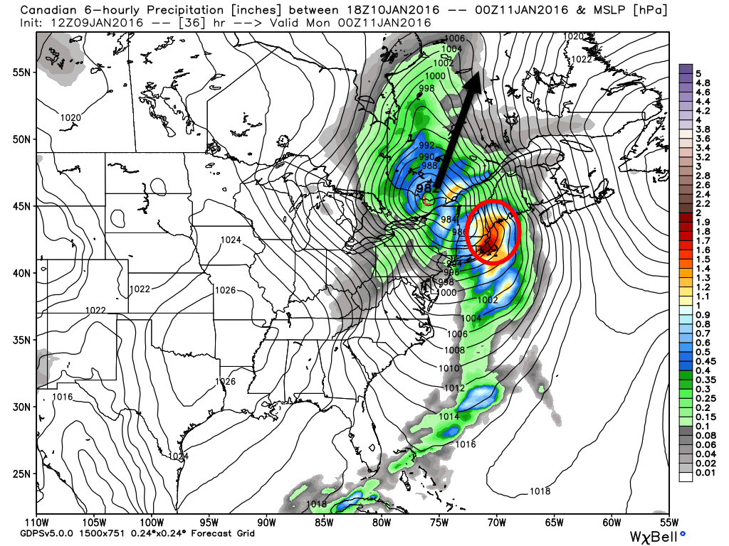
Not a lot has changed from this morning in regards to tonight’s forecast. Snow is ongoing across the area now but big accumulations will hold off until after around 9 PM when a very heavy band looks to sweep NE. As it does so, it will be intensifying and slowing down.
HRRR Model Showing Intense Snow Sweeping NE This Evening. Credit: Weatherbell
The farther NE you go, the heavier the band will be and the longer it will last. In this band, look for very intense snowfall rates of 2-4″ per hour along with gusty winds and potentially thunder. It won’t last terribly long for most, maybe an hour or two, but in that time, the snow will really pile up. If you are driving late tonight look for very dangerous driving conditions with near whiteout conditions. Thankfully, the worst of the storm will be from 9PM to around midnight. After that, the snow abruptly shuts off and NW winds pick up. Some snow showers could linger through tomorrow morning especially in the mountains and NE.
I still like my snow map from this morning. Remember, most of this falls in just a few hours late tonight. It will be quite a show if you happen to be awake for it!
Be careful tomorrow as winds will be gusting near 45mph which will blow around the new snow. The greatest threat for reduced visibility due to blowing snow is inland where the snow will be fluffier.
Initially there were concerns about coastal mixing and that is still possible but observations show cold air hanging tough for everyone but the outer peninsulas. Should this change between now and when the heavy band blasts through, areas east of Route 1 could see reduced accumulations.
Believe it or not, we got another storm lined up! More snow, possibly significant, could arrive Saturday. There are significant questions so the details will have to wait a while but know the potential is definitely there! Welcome to winter the way it should be!
A jucier than normal morning post today as the forecast for this evening is fascinating and very complicated. Before the snow arrives, look for increasing clouds with highs in the 20’s inland, low 30’s along the coast. Snow should arrive around 4 PM or a little after, then things get interesting.
0Z GEM Showing The Setup. Image Credit: Weatherbell
The setup from yesterday evening’s post remains largely the same this morning. Low pressure currently over Michigan will move E into southern Ontario this afternoon. Secondary low pressure will develop to our SW and move NE east of us. How fast this low develops is the key to the forecast. The general idea is that the combination of tons of upper level energy, warm ocean waters, and a favorable upper level setup (VERY negatively tilted trough for those that understand) will lead to rapid development just offshore.
0Z GEM Showing Intense Banding Across Western Maine Tonight. Credit: Accuweather
Intense snow bands will begin to develop along with the low but when and thus where these bands develop is still an unknown. We do now have a slightly better idea of where to look for the heaviest snow, the lightest snow, and where it could go either way. This is a very complicated situation and I mean it when I say there is high bust potential here. With that being said, I doubt York County sees much more than 2-4 or maybe 5″. It looks like things pull together just a little too late down there. The Midcoast and areas NE of Augusta/Auburn are likely to see a solid 6-10/8-12″ snow. It’s the areas in between that are really tricky.
This is what I anticipate snow amounts to look like. Uncertainty is very high especially NE of York County and SE of Augusta.
Even in areas without much accumulation in terms of raw numbers, expect difficult travel as the snow will fall very heavily. There is also the chance that those in the heaviest bands see thundersnow this evening as well.
The immediate coast could mix with rain this evening before the heaviest stuff arrives. If this happens, watch for a rapid refreeze which would cause dangerous travel in those areas. Right now I think the peninsulas are most at risk for this but anyone east of Route 1 should be watchful.
Snow moves out tonight leaving a cold and gusty wind for tomorrow.
My apologies on this post for an uncertain snow event going out so late and being so short, cramming in something that usually takes 4+ hours into 2 is hard. With that aside, I’ll do my very best to look at the forecast for tomorrow night in some detail below.
Overview
12Z GEM Showing The Setup Tuesday Evening. Image Credit: Weatherbell
A clipper system is currently moving across Minnesota and will continue to dive SE tonight into tomorrow morning. It will end up over the Eastern Great Lakes by tomorrow afternoon. At this time, a new low will form near NYC/Long Island and move NE as it strengthens. The key to this forecast and why it is so uncertain is how fast this low intensifies. I want to stress that the difference between a widespread 3-6″ and a widespread 8-12″ event is a few hours. If the storm forms a bit earlier, there is more snow. If it is a bit late, there is less snow. Either way, a burst of heavy snow is likely tomorrow evening around or a little after the evening commute. Overall, impacts should be minor but after 7 or 8 tomorrow evening, roads are likely to become quite slick.
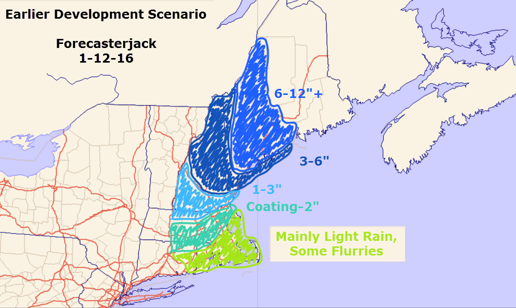
The Earlier Development Scenario
12Z GEM Showing Intense Upward Motion Leading To Very Heavy Snow Over Western Maine Tomorrow Night. Notice The Position Of The Red (Very Heavy Snow) Over Western Areas. Credit: Accuweather
This is the GEM model showing the earlier development scenario. At 11PM tomorrow night, an intense band of very heavy snow is located over Western Maine centered on a Portland-Lewiston line. In this scenario, intense snow bands develop earlier and farther to the west leading to higher totals across SW areas. Based on very warm SST’s offshore and the very high amount of energy blasting SE with the clipper, I think this is the more likely scenario. The 500mb trough will also be going sharply negative.
12Z GEM Showing The 500mb Factors In Favor Of Explosive Storm Development. Image Credit: Accuweather
A very negative trough with a ton of energy blasting over record warm ocean temps is a setup ripe for explosive storm development. The 12Z GEM shows this well. The other models show a similar setup and the GEM has shown itself to be very reliable when dealing with clippers and Canadian airmasses. It was the one model that caught the surprise no-show of the February 15 blizzard and I think it is on to something in terms of surprises with this storm.
This is what snow totals would look like if the low developed on the early side. Consider this my forecast.
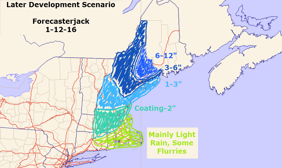
The Late Development Scenario
12Z GFS Showing Snow Bands Firing Up More Along The Midcoast Than The ME-NH Border. Credit: Accuweather
It is also entirely possible things don’t pull together in time and the heavy snow bands really get going more over the eastern Midcoast than the NH-ME line. The GFS shows this well. This is the same parameter (upward motion) for the same time as the GEM map posted above. Compare them and look at how much farther NE the heavy snow bands (bright colors) are on the GFS compared to the GEM. This is the difference between 3″ and 8″ for most areas SW of Augusta. Where these snow bands set up is the entire forecast at this point. It is important to note that the GFS shows nearly the same 500mb setup. The trough on the GFS is the exact same as on the GEM with the only difference being the GFS is 30 or so miles farther NE. That is the difference between 3″ and 8″. I really want to stress how tiny the differences are in terms of the science. 30 miles is a tiny margin of error, it just so happens that this time that margin of error has tremendous impacts for a large swath of the area. Be prepared for either scenario despite the forecast being for more snow.
This is what snow totals would likely look like given the late development scenario playing out. This is not what I expect to happen but it remains a viable solution. In fact, new clues have emerged since the making of this map that indicate that totals could be slightly less than this if the low really fails to get going. Don’t be shocked if you wake up Wednesday to only a few inches SW of Augusta. Several inches look like a safe bet for the Midcoast and the NE mountains.
Coastal Mixing Concerns
12Z GEM Showing Near Freezing Temps At The Coast. Credit: Weatherbell
Winds ahead of the clipper will be onshore and thus temps will be marginal at the coast. However, winds will turn N/NE as the coastal low develops which will act to shut off the source of warm air. Also, heavy precip acts to cool the air and precip will certainly be heavy tomorrow night. All added up, I think this will be a wet snow for most coastal areas with only the peninsulas seeing rain. Again, this part of the forecast depends on the coastal low. The faster the low develops the faster cold air rushes in.
This is a VERY uncertain forecast so I’ll try to have an in-depth update tomorrow morning with details. I’ll have another update tomorrow evening as the storm is beginning. At this point, the details will be more clear (helpful, I know!).
Today will feature mainly sunny skies, cooler temps, and gusty winds as colder air moves in on the back side of our storm from yesterday. Highs already occured at 12:01 this morning and temps will be dropping from the 20’s and 30’s this morning to 10’s and 20’s by this evening. Winds could gust over 30mph which could cause another power outage or two and will also lead to wind chills dropping to near zero in the north by sundown.
Today will feature the arrival of heavy rain along with high winds. Rain has begun across areas south of Portland and rain will continue to move NE through the morning. Winds are picking up as well with gusts over 30mph just offshore. Look for both rain and wind to pick up in intensity today with 1-2.5″ of rain and wind gusts over 50mph at the coast. Gusts over 60mph are likely along the midcoast. The highest winds will only last a couple hours but could be enough to knock down a few branches so power issues are possible, especially as you go farther NE. Some thunder is possible with the heaviest rain. The worst impacts will be during the late afternoon through the evening.
I’ll have updates throughout the day on the FB page and on Twitter as the storm develops. (FB: Forecasterjack Twitter: @JackSillin)
We’re heading into a period of active weather this week and our first storm is up tomorrow. This one is tracking to our west and thus we’re on the warm side. This will be an all rain event with temps soaring into the 40’s. Winds will also be extremely strong gusting near 60mph at the coast.
Overview
12Z GEM Showing Low Pressure Moving To Our West (Black Arrow) And Heavy Rain Over Our Area (Red Circle). Image Credit: Weatherbell
Low Pressure is developing over Arkansas right now and will move NNE tonight through tomorrow while strengthening. This storm will drive a cold front through the region tomorrow night. Ahead of the front, look for heavy rain, strong winds, and warm temps. Conditions behind the front look cold and windy as arctic air moves in. Now that we’ve set the stage, lets dig into the details.
Rain
18Z GFS Showing A Region-Wide 1-2.5″ Rainfall. Credit: Weatherbell
Rain will move in tomorrow morning and will become heavy by early afternoon. In terms of amounts, a general 1-2.5″ is expected with the highest amounts falling in areas where heavy rain is enhanced by upsloping SE winds. Any SE facing slopes are at risk for the 2-2.5″ totals. With the snowpack being marginal at best, widespread flooding isn’t likely but some rivers and streams could run high enough to cause minor issues in any usual trouble spots. A flood watch is out for much of the area due to this threat.
Wind
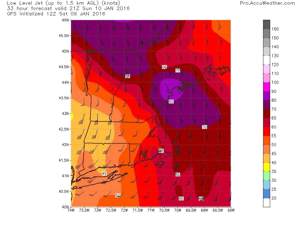
12Z GFS Showing Very Strong Winds Just Above The Surface. Credit: Accuweather
I think the biggest story will be the winds. The map at right is the winds just above the surface, NOT winds at the surface. The numbers on the map are knots so the winds between 2,500 and 5,000 feet are hurricane force. NOT all these winds will mix down to the surface by any means. That being said, winds will be very gusty as heavy rain helps to transport winds aloft down to the surface. Winds along the coast especially NE of Portland are likely to gust over 55mph. This could cause a few isolated power outages so watch for those if you usually see darkness during storms like this. All in all, not a massive windstorm but some branches are likely to come down and could cause a few issues. Also be sure to secure anything that might blow around outside (sleds, shovels, etc).
Other Impacts
There could be some thunder in the heaviest precip. Nothing crazy but that’s not something we usually hear here in Maine in January especially with rain (thundersnow happens sometimes with strong Nor’easters but rarely to we break enough into the warm sector for thunder).
On the back side of the storm, cold air will be rushing into the region on strong NW winds. Look for subfreezing air to blast into the area Monday and any leftover puddles will freeze. As a result, look for slick roads Monday and Monday night.
SE winds will be strong tomorrow but won’t last for a long time. As a result, coastal flooding impacts should be minimal. Some splashover/erosion is likely and the usual trouble spots could see some issues but no major impacts are likely.
Cold air moves in Monday and lasts through the week with snow threats midweek and next weekend. Those are still far out so details will have to wait to be figured out.
I’ll have another update tomorrow morning. I’ll also have updates through the day over on the Facebook page.
Today will feature mainly cloudy skies as high pressure slides offshore. As it does this, winds will turn easterly blowing moist ocean air across the area. Low level cold in place will result in some snow bands especially near the coast. These will continue through the day. Accumulations are expected to remain under an inch or two. Freezing drizzle is also a possibility and some rain could also fall along the southern immediate coast mainly south of Portland. Highs will range from the 20’s north to low 30’s south.
Heavy rain and high winds will blast the area tomorrow. I’ll have a full update on that this evening.
Today will feature increasing clouds as high pressure shifts offshore. Look for low-level clouds and possibly even some drizzle to move in this afternoon/evening as winds turn easterly. With temps in the low to mid 30’s today, any drizzle would have to be considered freezing drizzle as temps hang right around the freezing mark. This will be much more of an issue tomorrow but watch out for it today as well. A few slick spots are possible across the coastal plain this evening.
Light snow, sleet, and freezing drizzle impacts most areas tomorrow before heavy rain and high winds Sunday. Cold returns Monday/Tuesday before a snow threat Wednesday.