Rarely will 40 sunny and calm feel as nice as today following one of the wilder roller coasters we have seen in a while. Look for clearing skies, gentle breezes, and temps in the 30’s north and 40’s south.
Some rain and snow is possible Saturday but no big storms are in sight until maybe early next week.
HRRR Giving An Idea Of What To Expect With Frozen Precip Tapering Off This Morning Then Heavy Rain Arriving This Afternoon. Credit: Weatherbell
Today will feature all four seasons as low pressure passes to our west. We’ll start with a slippery, wintry mess this morning as freezing rain and sleet fall on top of already fallen snow. Spring comes mid day as SE winds scour out the cold in place leading to warming temps. Some showers are possible in typical April fashion. Fast forward to July come evening as a line of heavy showers and thunderstorms approaches from the west. This line will mix down some of the 90kt+ winds a couple thousand feet above our heads leading to wind gusts along the coast of 50-60mph+. Winds gust through the night as fall arrives and temps gradually cool back to winter for tomorrow. I’ve covered each threat individually in my update last night so check there for the details. Do note however that my thinking for winds this afternoon has increased fairly significantly and power outages are likely with the ice still leftover from this morning combined with the strong winds will likely lead to downed trees/branches. This threat begins as winds start to crank mid afternoon and will wind down early tomorrow morning as the winds aloft move east. The greatest threat will be with the line of showers/thunderstorms this evening.
Snow is moving into Southern New England this evening ahead of our next storm and snow will move NE into our area tonight. Snow mixes with and changes to freezing rain tomorrow morning before a lull tomorrow afternoon. The lull ends with heavy rain and wind Tuesday evening before we clear out and cool down Wednesday morning.
First Round: Frozen Medly
Evening Radar Showing The Setup For Tomorrow. Image Credit: Accuweather
The general idea from Yesterday remains the same but with a few tweaks. Snow will move in from SW to NE this evening beginning around 7 in York County. Radar is indicating snow is falling across York County however with VERY dry air at the surface, I doubt this is making it to the ground. The ground is very cold and thus snow will accumulate quickly and efficiently once it starts falling.
Snow will fall throughout the night tonight and will accumulate to 1-3″ before warm air aloft begins to change snow to ice around or a little after midnight. Along the coast and across the coastal plain, this is all the snow you’ll get. For inland areas, another inch or two is likely bringing total snow to 2-4″. The mountains hold on to snow the longest with 3-6″ of accumulation. While the mid levels of the atmosphere get torched by a 50kt+ Low Level Jet, the air right near the surface will remain cold as cold dense air settles to the surface. For this reason, expect freezing rain to be the dominant precip type tomorrow morning with some sleet mixed in towards route 2. This will lead to a VERY slippery morning commute with roads a total mess due to several inches of snow under some sleet under a layer of freezing rain.
Second Round: Tropical Punch
18Z NAM Showing Very Strong Winds Aloft Tomorrow Evening. Image Credit: Accuweather
Freezing rain will continue through mid to late morning tomorrow before tapering to freezing rain showers as a dry slot briefly works in. During this time, the cold air will gradually be mixed out as southerly winds kick in. Precip will resume tomorrow evening as a cold front approaches. This round will be mainly rain except maybe for some isolated mountain valleys. Rain will be heavy at times and thunder is not out of the question as the cold front moves through. Winds will be gusty at this time as well with gusts over 40mph possible. Winds will be limited however by how much the cold air hangs on. The longer the cold hangs in, the more wind we see. Some power outages are possible during this time though significant impacts seem unlikely.
Rain moves out late tomorrow night with clearing and cooling expected Wednesday. More snow/rain is possible for Friday as a clipper system moves over the area.
Today will feature bitter cold temps this morning burning off to relatively warm afternoon highs. Current temps this morning range from -10 near the coast to -20 in the mountains. Thankfully, winds are a bit lighter this morning so wind chills are generally on the warmer side of -30. Fading sun will be enough to drive temps out of the ditch they’ve been in for the past few days and highs today will be toasty compared with the past 36 hours. Look for mid to upper 10’s north and low to mid 20’s south.
Snow arrives this evening from north to south in advance of our next mess of a storm. Check out my full dissection of the storm from yesterday evening. I’ll have another update on that this evening.
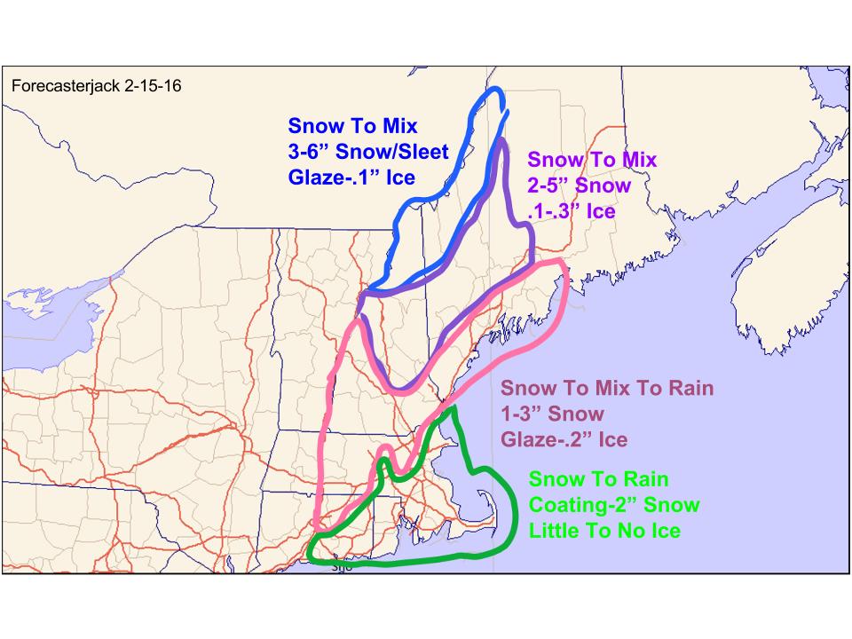
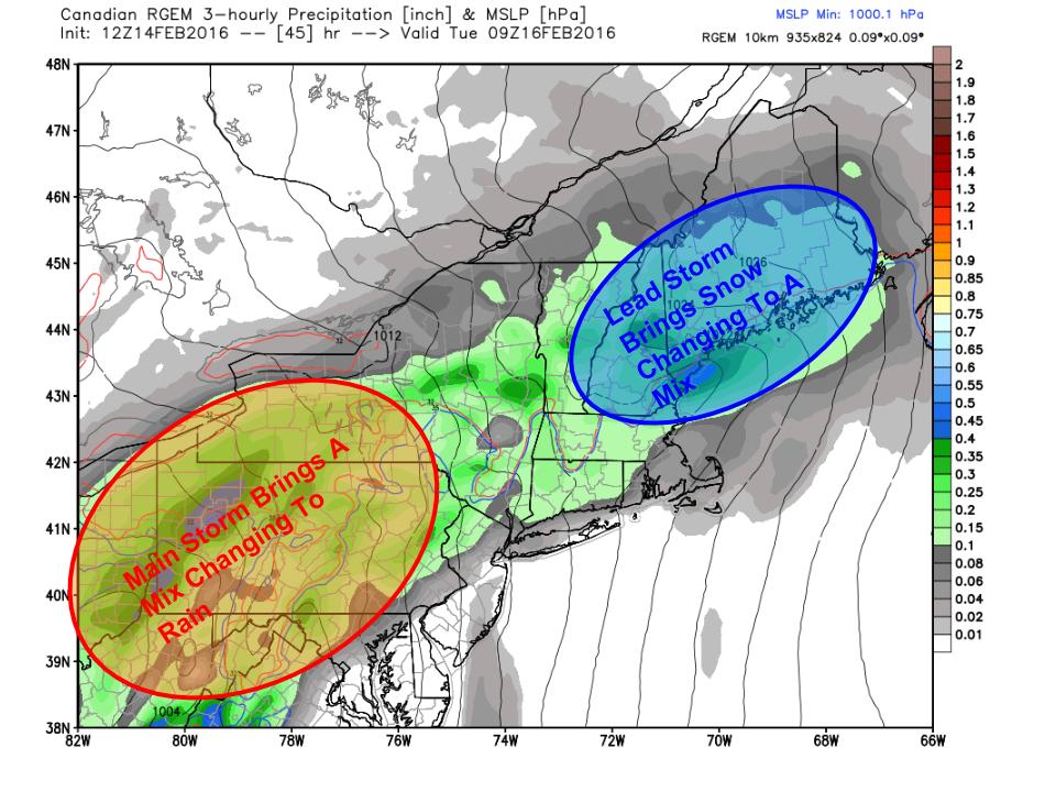
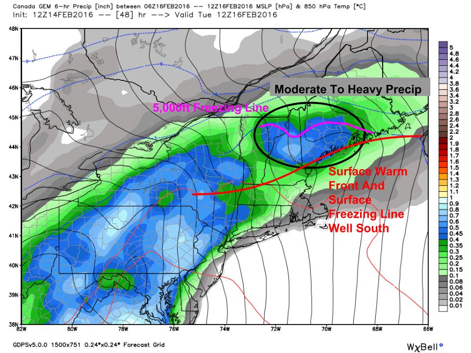
Low pressure will pass through the area in waves tomorrow night through Wednesday. The track of the main low will be to our west so this will be a snow to mix to rain event even in the mountains. Snow, freezing rain/ice, flooding, and wind threats with this storm. I’ll outline each below broken down by wave. The first wave is the cold phase of the storm with snow and mix while the second wave is almost all rain. There is a chance we see a third wave on Wednesday with more snow but that is far from certain. Let’s dig into the forecast.
The Setup
12Z RGEM Outlining The Major Players In Tuesday’s Storm. Image Credit: Weatherbell
Here is the RGEM model for Tuesday morning showing the major players. A storm is moving across the southern Ohio valley right now and will move into VA tonight. It will then move NE along a warm front and that will deliver our first shot of precip. Given how darn cold the air is out ahead of this storm, I am hesitant to jump at warm air blasting in without a fight. That being said, SW winds will have all of Monday to moderate the air before the storm even arrives. Also, the high pressure system containing the cold air will be retreating offshore which means it won’t be funneling cold air into the area through the event. Instead, counterclockwise winds around the high to our east will help promote strong southerly winds which will greatly help warm air coming north.
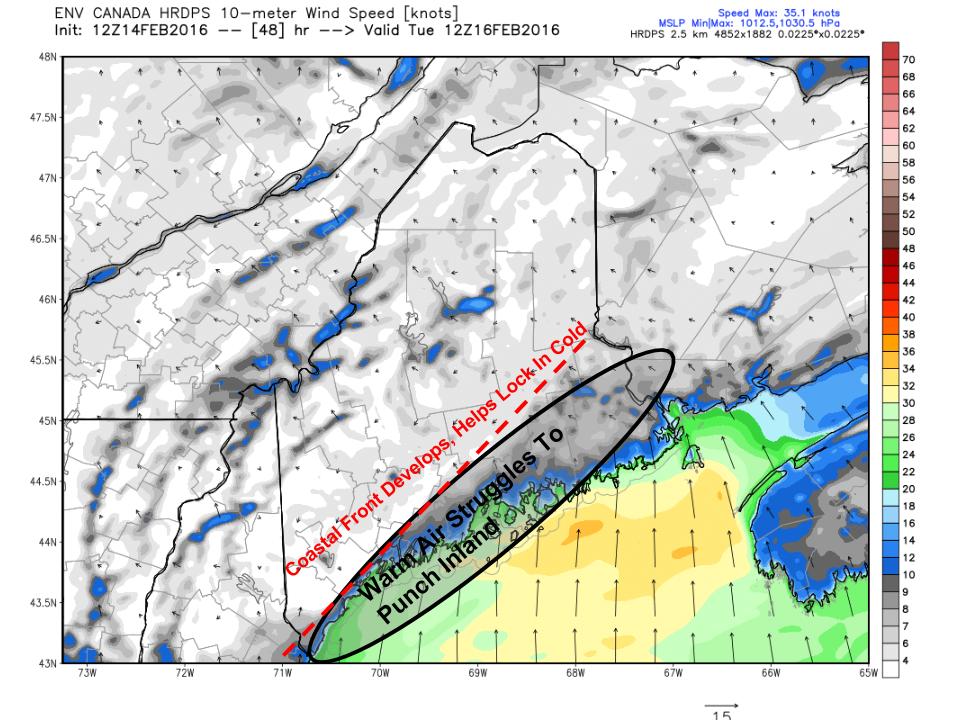
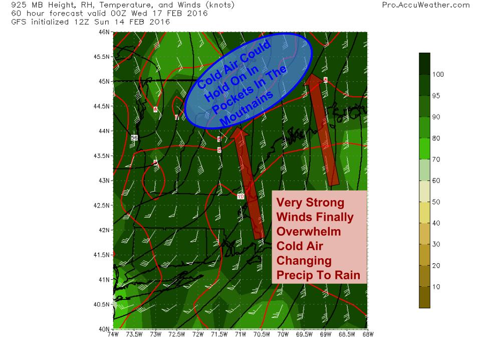
First Wave: Cold Air Hangs On
12Z HRDPS Showing How Cold Air Could Hang Tough Tuesday Morning. Image Credit: Weatherbell
The first wave of precip will arrive tomorrow night and will initially be in the form of snow. Several inches will accumulate by Tuesday morning and this will cause the Tuesday morning commute to be messy. Use extra caution and allow for extra time to get to work/school. The mesoscale higher resolution models such as the RGEM and HRDPS are holding the cold air in place much longer than the lower resolution global models. This is a good indication that cold air will hang on unusually long, as it almost always does in Maine in February after an Arctic blast with a solid snowpack on the ground. For those reasons, I am hesitant to believe fully that anyone but the immediate coast changes to rain before midday Tuesday. My time forecasting here has taught me never to underestimate the sticking power of Arctic air.
As the first wave moves through Tuesday, winds aloft will be blasting the area with a blowtorch, sending warm temps deep into the area. Cold air aloft is easy to displace. However, cold air at the surface doesn’t like to go anywhere in a hurry. The 12Z GEM shows this well. Tomorrow morning, the surface freezing line will hug the surface warm front offshore. The low level cold will dam along the mountains and will generally be sluggish in terms of going anywhere. In between the freezing line aloft and the freezing line at the surface, there is the risk for freezing rain. For the foothills, this could be a respectable freezing rain event with amounts of a tenth to as much as a third of an inch possible. Depending on exactly how much warm air moves in aloft and exactly where in the atmosphere it does, sleet is also possible. The mountains will remain cold enough for snow for most of this time as the upper level warmth won’t quite make it there in time for the first wave. The coast will likely see the surface warm front move just far enough inland to bring temps above freezing leading to rain.
First Wave: Accumulations
Here’s what I’m thinking for accumulations for the first wave from tomorrow night through Tuesday evening. After Tuesday evening, everyone most likely changes over to rain as warm air streams in. This could be a significant enough icing event for the foothills to lead to scattered power outages especially if the inversion can break enough to allow for gusty winds with the second wave Tuesday night. Most of this is washed away Tuesday night with the rain but it will be quite slippery for both the AM and PM commutes Tuesday the more so the farther inland you go.
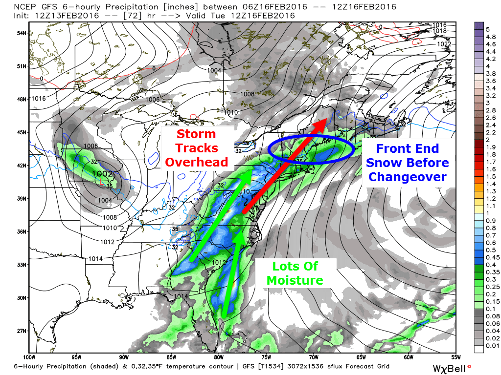
Second Wave: Cold Air Washed Out
12Z GFS Showing Strong Winds Just Above The Surface Pumping Warm Air Into The Area. Image Credit; Accuweather
After the first wave departs early Tuesday afternoon, we will see a lull in the action before the main storm passes well west of the area. The initial wave will help lift the warm front north of the region and warm air will begin to stream into the entire area. By the time round two arrives Tuesday evening, almost everyone will be warm enough for rain. Winds will become quite strong out of the south and south east aloft and there is the risk that some of those gusts mix to the surface in some capacity though a strong inversion will keep the serious winds mainly to our south. Especially along the coast though there is the risk for gusts up to 35mph. The warmer your temperature, the higher your risk for winds which is why the coast is at the greatest risk for wind. The mountains and especially the mountain valleys do an exceptionally good job holding on to cold air and I wouldn’t be surprised to see some mountain spots hold on to some variety of frozen precip throughout the whole event. The farther north and west you go the more likely this is. A general .5 to 1″ of rain is expected with this event which could lead to isolated flooding with frozen ground and a little snowpack.
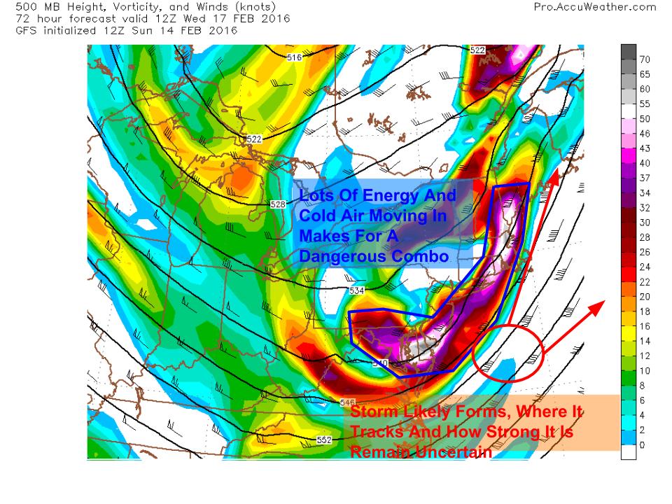
Third Wave: Surprise Snow Wednesday?
12Z GFS Showing A 500mb Setup That Is Dangerous For Surprise Snow Wednesday. Image Credit: Accuweather
The rain moves out quickly Tuesday night and cold air moves back in for Wednesday. Another storm is right on the heels of this one but right now the thinking is it stays south. However, the 500mb setup pictured is dangerous for surprise snow with a long nose of energy pointed right at us. Most likely a storm forms and models are currently thinking it heads well south but I’m not fully convinced yet. Even without a robust surface storm, trouble could still be caused by upper level energy. It is also possible enough dry air moves in behind the rain that we don’t get anything. We’ll have more clarity on this once we figure Tuesday out which might just be on Tuesday.
A period of cool calm weather arrives Thursday into Friday and another storm threatens for Saturday with a mix of snow and rain likely.
Today will feature mainly sunny skies, bitter cold temps, and wind chills straight from the north pole. Highs in terms of actual temps will rise to between 5 and 10 below in the north while the coast cooks to between 5 and 10 above. Those are actual temps, wind chills will make those seem temperate as NW winds continue to howl at least for this morning. Winds should die off this afternoon as high pressure builds in. Before that, wind chills this morning rage from 50 below up north to 30 below in the south. Yeah it’s that cold.
I’ll have another update tonight with more info on Tuesday’s storm.
With today’s Norlun trough fizzling out over the Midcoast and cold air pouring in as forecast, attention can now turn to a mid-week mess due to arrive Tuesday across the area as low pressure passes over the region. Because the low will be passing over us and not to our east, this will be a mix event with a medley of precipitation types including but not limited to rain, snow, sleet, and freezing rain. I’ve covered tonight and tomorrow’s bitter cold several times in the last few days so refer to last night’s blog post for the most recent info on that. Nothing has changed since then. With that said, let’s dig into the Tuesday storm.
12Z GFS Showing The Setup For Tuesday. Image Credit: Weatherbell
The Arctic high pressure containing the bitter cold we feel tonight and tomorrow moves offshore Monday bringing behind it warm SW winds. Temps will rise on Monday but keep in mind, they have a lot to rise as temps Sunday remain largely below 10 degrees. The airmass ahead of the storm is also extremely dry so there will be room for evaporational cooling at the onset of precip. I think we get a good burst of snow at the start of the storm across the area before warm air intrudes from south to north (this looks like a solid front end thump event for those familiar with New England weather terminology). How far north that warm air makes it and how fast it makes it there will determine precip type and thus what accumulations will end up being.
12Z GFS Showing The Arctic High Moving Offshore Monday Evening Leaving In Its Wake Warm Southerly Winds. Image Credit: Accuweather
How do we go from 20 below zero to rain in a matter of days? The answer lies in the placement of the Arctic high pressure. Notice how the high has departed to the east on Monday and behind it, warm southerly winds are already eroding the cold in place long before the storm gets to us. This is why I’m not super bullish on cold air remaining locked in. That being said, I’ve learned over my time forecasting in Maine that cold air has tremendous sticking power and is not easily moved. This is why I think the mountains stay mainly snow while the rest of the area only briefly sees rain with the exception of the coast where there will be more rain.
12Z GFS Highlighting A Rough Idea For Dominant Precip Type Tuesday Afternoon. Image Credit: Accuweather
In terms of what sort of precip will fall from the sky, the short answer is too early to tell exactly. However, I do feel comfortable roughly outlining my thoughts for general precip type. I think the mountains is mostly snow as the low passes over the coastal plain. They look to remain on the cool side of the low and even if the low passes over the mountains, I think you’d be hard pressed to get enough warm air that far north-west to allow for an extended period of rain. I do think though that the mountains mix with some sort of sleet/freezing rain at some point. The coast is the other higher confidence forecast (relative to the storm in general, confidence is medium at best with any aspect of the storm). The low would have to track significantly farther south than forecast for cold air to remain in place throughout the storm. For coastal areas, look for snow changing to a mix then changing to rain with briefly heavy rain possible. For inland areas, expect some sort of a mix with snow at the onset and rain to finish. What happens in between is anyone’s guess. Confidence will increase in the coming days so stay updated for the latest info.
I’ll try to have an initial guess at accumulations tomorrow evening in my next update on the storm. I’ll have tomorrow’s forecast as usual tomorrow morning.
Today will feature mainly cloudy skies, cold temps, high winds, and snow as winter finally shows up in a real capacity at least for a couple days. Look for highs today to struggle into the single digits above zero north and the 10’s south late morning before dropping below zero area-wide tonight. Lows tonight will be dangerously cold with actual temps of 15 to 25 below north and 5 to 15 below south teaming up with 25mph NW winds to create downright dangerous wind chills. Wind chills in the mountains will range from -30 to -50 (colder at elevation, the summits above 4,000 feet willl see even more extreme wind chills) while the coast and foothills see wind chills ranging from -20 to -40.
Across the midcoast, things get really interesting today as a Norlun trough develops. 6-10″ of snow is likely wherever it sets up and thumps though it remains to be seen exactly where that is. I went into detail about the forecast and also about how Norlun troughs work in my blog post last evening which includes my snowfall forecast. Farther west, snow showers and flurries are possible today but accumulation will remain under an inch with the exception of the mountains where a few inches of upslope are possible.
I’ll have more updates on the cold tonight and a messy storm threat for midweek this evening.
Cold air is firmly entrenched today but even colder air is on the way. Look for a cold front to smash SE tonight bringing behind it the coldest air all season and the first truly Arctic air we’ve seen all season. As the cold air moves in, an upper low diving to our south will set the stage for a Norlun trough event along the midcoast tomorrow. Beyond that, bitter and dangerous cold arrives Sunday followed by a messy storm midweek next week.
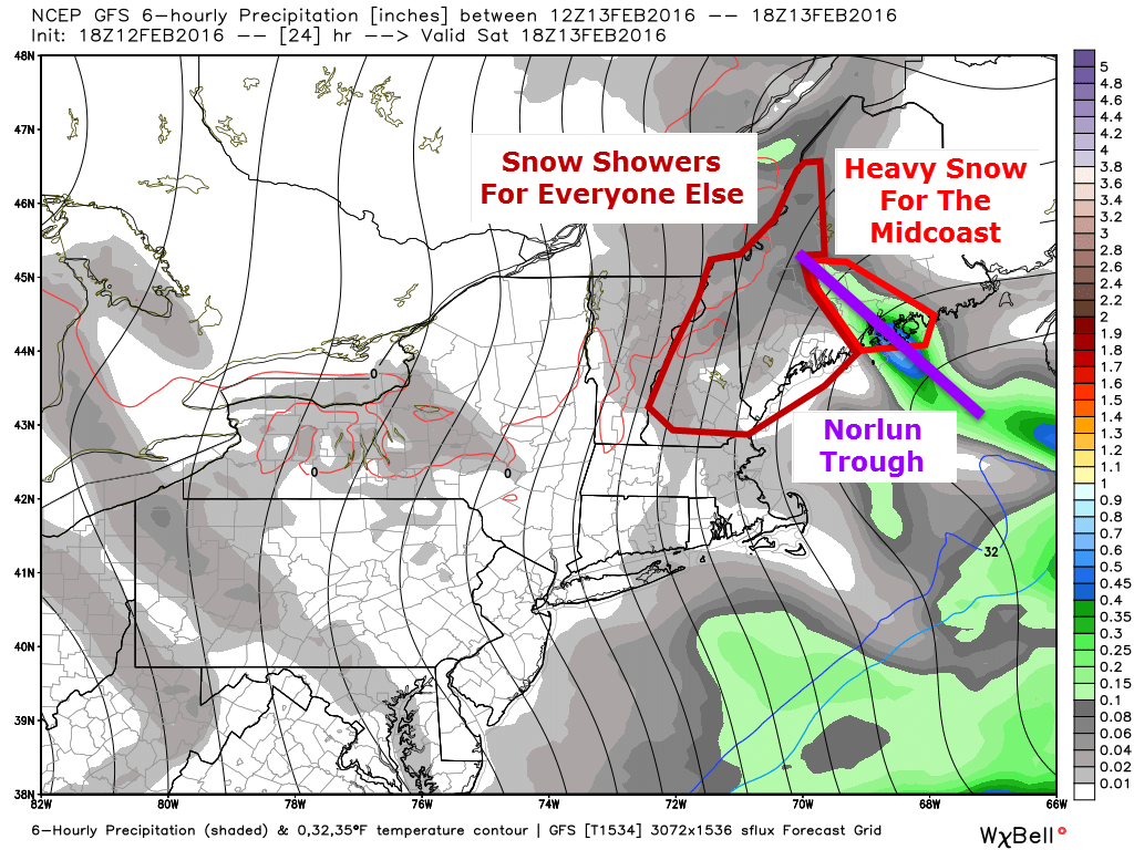
Saturday Norlun Trough
12Z GFS Showing The Setup For Tomorrow. Image Credit: Weatherbell
The front gets hung up along the midcoast as the upper low slides to our south. Winds out ahead of the 500mb trough will turn southeasterly and eventually easterly which will provide a mechanism for moisture to be transported into the region. Also, with southeasterly winds aloft, there will be nothing to move the trough once it sets up. Most of us will see the moisture transport aloft in the form of light snow/snow showers during the day tomorrow with light accumulations. The midcoast will be the only area to really capitalize on that. To understand why, read the next paragraph about how Norlun troughs work. If you’re more interested in the forecast, skip on down to the next picture and read about the cold coming Sunday.
A Look Behind The Scenes At Norlun Troughs
Here is a graphical explanation of a Norlun trough I did for UpPortland. Notice that tomorrow the trough will be over the Midcoast rather than Portland. All rough image design credit goes to me (and Frontpainter for the map)
Because it’s been so warm recently, the ocean is still quite toasty. This sets up a very large difference in temperature between the warm ocean and the cold air. The warm water will heat the lowest level of the atmosphere creating warm air which wants to rise. Above this very shallow layer of relative warmth lies an entire atmosphere of very cold air which wants to sink. Somewhere in the impenetrable fortress of cold, there will be a weakness. The warm air will rush upwards through this weakness generating tremendous upward motion and leading to warm moist air crashing into cold dry air. This violent collision will produce snow.
A Cross Section Of The Atmosphere Showing The Dynamics Involved With The Trough. More Rough Image Design By Me.
As the new trough takes up the energy immediately near it, warm air trapped under the cold air all across the Gulf of Maine will rush in to take its place so it too can rush upwards and cool. As the trough is using up the existing warm air, new warm air will keep being created as the water continues to warm the lowest levels. This warm air will rush to the weakness in the cold and rise up, depositing its moisture along the way. This is what we call a Norlun trough.
One of those will form over the midcoast and deposit heavy snow tomorrow. Totals are likely to come it at around a foot in the core of the trough but it remains to be seen exactly where that sets up. These events are notoriously fickle and can set up wherever they please or not at all. One good example happened just last night when a weak Norlun formed over Portland out of left field causing major issues. Bottom line: expect the unexpected.
Expected Snowfall. Notice The Sharp Cutoff Which Leads To High Uncertainty From Brunswick On East To Rockport.
Expected snowfall for tomorrow. Upslope snow showers in the mountains are likely to produce 1-3″ in the usual spots. Farther south, a dusting to as much as 2″ is possible with isolated snow showers/flurries. In the core of the Norlun, thundersnow is possible as there will be a solid amount of instability associated with the temperature falling dramatically with height from the warm ocean to the bitter cold air moving in aloft (technical: lapse rates will be very impressive).
NW winds will be howling tomorrow beginning in the afternoon. While blowing and drifting snow will initially not be an issue, by Saturday night, those who saw snow will also see it blowing around leading to more slick spots and reduced visibility. It will also add an extra sting to the air if you happen to be out and about Saturday night.
Very cold air is still on track to come into the area behind the storm on Sunday. Actual temps will drop well below zero and as NW winds howl at over 25 mph, wind chills will drop even lower. This is the image I used for last night’s post and it still applies as wind chills approach -40 to -50 in the north with -20 to -30 degree wind chills in the south. Bundle up for the Valentines Day dates both Saturday and Sunday nights. Thankfully, the extreme cold is out on Monday.
Messy Midweek Storm
12Z GEFS Showing The Range Of Possible Outcomes And The Lack Of Confidence Regarding The Forecast At This Point. Image Credit: Weatherbell
As the cold retreats, we have another storm threat. We are virtually certain to see precip the question is of what variety. Right now, it looks like a mess with all precip types possible for everyone. It is far too early to nail down exact impacts or amounts but total accumulation of whatever falls could be significant. My thinking from yesterday still applies in that uncertainty remains large here. One group of forecast models leans towards a colder, farther east solution with more snow than mix while another camp of models leans towards more rain and mix than snow.
Another storm is on the horizon late next week but we have to get the first two resolved before we can dig into that one. Just know that there is the potential for a storm and as always, ignore any hype you may see.
I’ll have more updates in the coming days as the midweek storm becomes clearer. I’ll also be on Twitter watching the Norlun trough evolve tomorrow @JackSillin.
Today will act as our dress rehearsal for Sunday as cold air pours in from the NW. Despite how cold it feels out there now (wind chills ranging from -10 to -20), this will be mild compared to the cold on Sunday (wind chills getting close to -50/-60 in the mountains, -30/-40 at the coast). Remember, bundle up and limit your outside time if you can. Doesn’t take long for your skin to freeze at these temps. Actual temps will rise into the 10’s and low 20’s, coldest north. Winds will also die down as high pressure settles over the region ahead of the real cold front across the Great Lakes. Skies will be sunny so at least there’s that.