Delightful Weather Today Post-Dorian

Hello everyone!

Today will feature some pretty delightful weather in the wake of Dorian which is now an extratropical cyclone near Newfoundland. This morning, a band of clouds extends from the Mountains to the Midcoast with overcast skies reported underneath it. That band should break up a bit as we move later into the day, with a mix of sun and clouds expected area-wide. The most sun will be found in southern NH while the most clouds will generally be found in the typical upslope regions of the mountains.

Dew points today will be fantastically low, a few degrees above 50 near the coast and around 45 inland. That’s just about perfect as far as humidity goes this time of year! Temps will be similarly nice, ranging from a few degrees below 60 in the mountains to a few degrees above 70 in SE NH.

No precip is expected today in dry NW flow. Enjoy the beautiful weather!

-Jack

On The Edge Of Dorian Today

Hello everyone!

Today will feature unsettled weather as we sit on the edge of Hurricane Dorian. Radar imagery this morning shows a few areas of shower activity across the region, one associated with the upper level trough steering Dorian NE, and the other associated with the hurricane itself.

The trough showers are slowly fading as they meander through E NH, but will continue for a couple more hours due to favorable upper level dynamics. The main rain shield will keep trying to advance west for the next couple hours, but it will keep being beaten back by low level dry air. By the time we get to the later morning hours, this rain will be rapidly exiting to the east and most of the region will end up dry by this afternoon.

In addition to the showers, being on the edge of Dorian’s circulation means we’ll also get some some breezy winds. As of 7 AM, most sites in the eastern part of the region were recording 10-20 mph winds which is about what to expect for the rest of the day, though some gusts over 30 are possible especially along the Midcoast.

High temps today will range from 55 in the northeastern mountains to a little above 70 in SE NH.

-Jack

Clouds Increase Today Ahead Of A Brush With Dorian

Hello everyone!

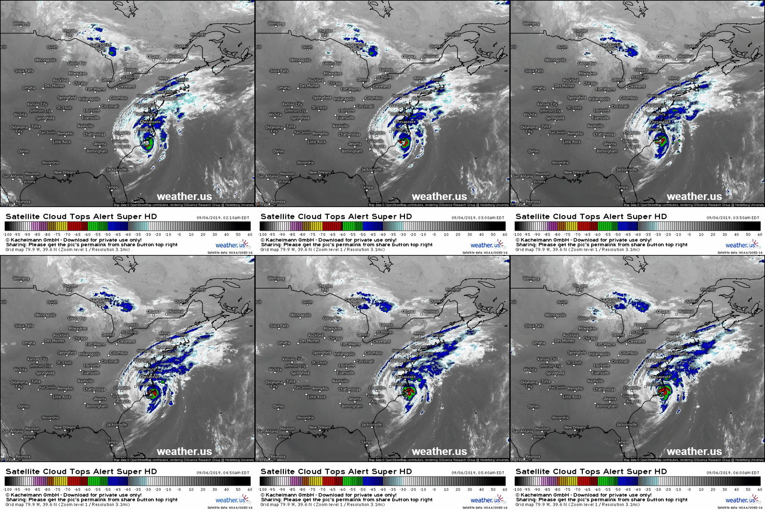
The eye of Hurricane Dorian is located about 15 miles south of North Carolina’s Outer Banks this morning and is moving northeast at a brisk pace. The storm will pass just outside the 40N 70W ‘benchmark’ we use to forecast winter storms around 2 AM tonight. Just like a winter storm, this track means we’ll be at the edges of the storm, close enough to know it’s there but far enough for it not to be all that big of a deal.

Ahead of the storm, we’ll see increasing high clouds today. The clouds you’ll see are actually streaming north directly from the hurricane’s center, as shown by the satellite loop above. It’s pretty cool to think that the moisture producing those clouds came from the warm waters of the tropical Atlantic before rising through the storm’s powerful updrafts, getting pushed out of the top of the cyclone, and finally carried by the jet stream far to the north and east.

Back to our local weather, while clouds will be increasing today ahead of Dorian, any rain from the storm should hold off until near sunset (Southern NH) or after (everyone else). The best chance for rain overnight tonight will be along the coastal plain, where a few heavier showers are possible tomorrow morning before rapid clearing tomorrow midday/afternoon.

High temps will generally fall in the mid to upper 60’s today with slightly cooler temps in the north, and a few spots near Waterville perhaps touching 70.

-Jack

A Really Nice Early-Fall Day Today

Hello everyone!

Today’s weather looks really nice as cool, dry air moves in from Canada behind yesterday’s cold front. Expect seasonably cool temps ranging from 60 in the north to a little above 70 in the south. Skies will be mostly sunny today outside of some cirrus moving east from a frontal boundary in Canada as well as north from Hurricane Dorian down in South Carolina. Enjoy the beautiful weather!

-Jack

Fast-Moving Cold Front To Bring Showers And Storms To The Region Today

Hello everyone!

Today will feature the passage of a very fast-moving cold front as low pressure races off to our north. Humidity is already on the increase this morning, which you’ll notice if you step outside particularly in southern areas. Some low clouds are noted across the region this morning with Rockland reporting 1/2mi visibility in fog which is another sign of the more humid airmass moving north.

Fog and low clouds will erode somewhat with daytime heating, and temps today will be on the warmer side compared to recent days. Look for highs around 65 in the north and a little above 80 in SE NH.

The patchy sunshine and warmer temps will provide some fuel for shower and thunderstorm activity today as the front actually crosses the region. This activity should arrive in the CT River valley around 2-3 PM before moving quickly east. Most of us should get at least some showers while some of us will get strong to severe thunderstorms. The stronger cells will produce damaging winds, small hail, and one or two might even produce a tornado given how strong the winds are aloft. Be sure to have a way to receive warning information if the NWS was to issue a severe thunderstorm or tornado warning today.

Thunderstorms will depart the region from west to east this evening with the entire region (except perhaps for the eastern Midcoast) seeing mostly clear skies by sunset.

-Jack

In Between Weather Today

Hello everyone!

The best way to think about today’s forecast is that we’re in between two weather systems, though the last one (yesterday’s rain) wasn’t quite strong enough to create a good push of Canadian air behind it. With that in mind, we’ll have residual low clouds this morning across much of the area but especially NE of Portland and NW of the mountain ridges. A deeper layer of clouds is located just over the Canadian border, and will be moving through the northern mountains from time to time today. While there won’t be much in the way of rain today, a few showers are possible in the mountains as that deeper cloud layer moves in.

High temps will range from the mid 60’s in the north to the upper 70’s in the south.

More showers and thunderstorms will arrive with the next cold front tomorrow.

-Jack

Showers And ThunderstormS Cross The Region Today

Hello everyone!

Showers and thunderstorms will cross the region today ahead of a weak cold front currently over Western New York. We won’t have enough instability to worry about severe weather, but unfortunately it won’t be a great day for BBQ on the beach. Showers are ongoing across all but far SE NH and Midcoast Maine as of 5 AM. While SE NH will likely see rain develop in the next few hours, Midcoast Maine probably stays dry until the midday hours. The best chance for rumbles of thunder will be in Southern NH later in the afternoon/evening.

Skies will be overcast for just about everyone today as highs rise into the upper 50’s north and upper 60’s south.

For those who may have an interest in Hurricane Dorian which will impact Florida, Georgia, South Carolina, and North Carolina this week, please head on over to blog.weather.us for my latest updates on that storm.

-Jack