
Hello everyone!
Hopefully everyone took advantage of the nice weather yesterday to batten down the hatches ahead of today’s storm. That storm is currently developing rapidly over the Great Lakes and will be responsible for bringing a wide variety of wild weather to the area today.

Radar imagery this morning shows steady rain approaching from the southwest while showers pop up ahead of the main line. Those lead showers look to be fairly heavy while the steady rain seems much lighter. The only mostly dry part of the region this morning is the northern mountains which will see rain beginning in the next 1-2 hours.

Rain will continue steadily for most of the day, with perhaps a few drier breaks early afternoon between bands. Most spots will pick up 1-1.5″ of rain from this event with 2″+ totals expected along south/southeast facing slopes of the mountains and possibly also along the coastline. This amount of rain will be enough to push small rivers/streams to bankfull or perhaps a bit over. If you live in a low-lying area near a river or stream that usually floods in heavy rain events, prepare for high water. Otherwise, be mindful of high water on roadways if you need to head out.
By far the bigger impact from this storm will be the wind.

Winds just above the surface today will be nothing short of incredible. Sustained winds along the coastal plain will be rocking 80-100+ mph just 2,000ft above the ground. The big question is to what extent can those winds mix to the surface (or pine-tree-level).
The answer will be found in low-level temperature profiles. If temperatures warm with height, it’s really hard to get high winds to the surface because fast-moving lower-density warm air doesn’t want to punch through a layer of slower-moving higher-density cold air. However, if temperatures are nearly constant with height (or cool with height), that higher-momentum air can reach the surface much more easily.
That’s where the shading on the map I made above comes in. Red areas represent regions where temps warm with height. That makes sense as the Gulf of Maine is chilly this time of year so over the ocean, the surface (water) is cold while warm air moves in aloft. Over land however, temperatures are either constant or cooling with height especially over the Coastal Plain east (or within a couple dozen miles) of the Turnpike. This is the area to watch for the strongest wind gusts.
How windy are we talking?
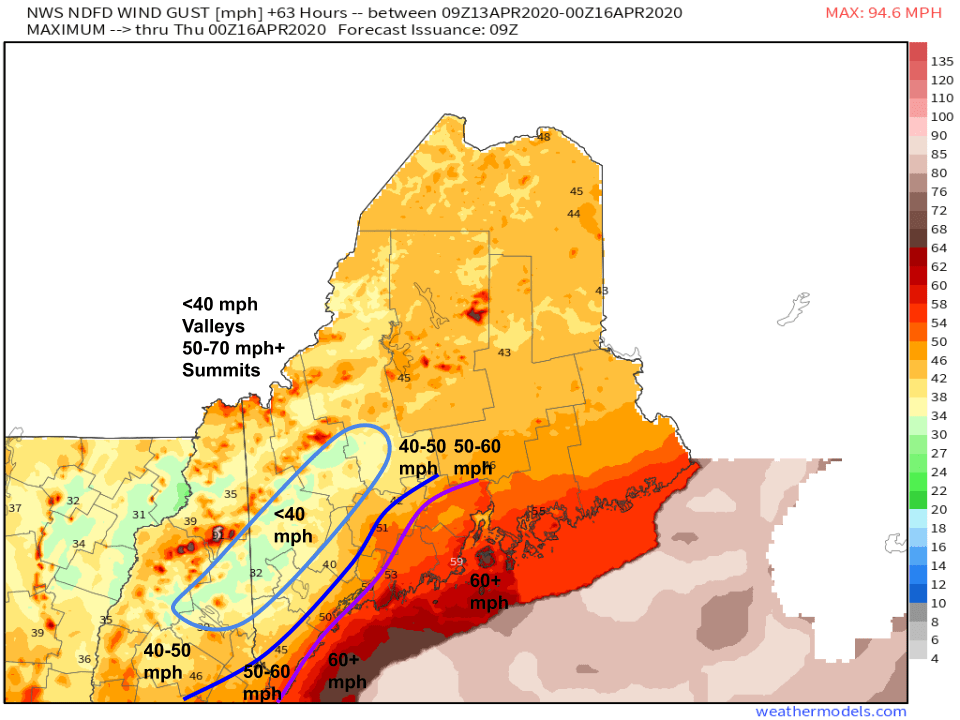
Here’s the NWS’ current forecast (shaded) and my thoughts (contoured). The foothills will be most sheltered from these winds due to weaker winds aloft and colder temperatures near the surface. Gusts there should end up in the 30-40 mph range. In the mountains, winds will be elevation-dependent with gusts in the 30s in the valleys and 50s-60s+ on the ridges/summits. The highest (lower elevation) gusts will be found along the coastal plain east of I-95. Overall I’m in good agreement with the NWS forecast except for the interior midcoast east of I-95 and north of route 1. I think that area is likely to see gusts >60 mph ad favorable thermal profiles offset slowing due to friction.
Either way, expect another round of widespread power outages beginning early/mid afternoon.
Rain and wind will both taper off this evening as the storm rapidly moves east.
-Jack
