All posts by Jack Sillin

I’m a third-year atmospheric science student at Cornell University who has been blogging about the weather since 2011. While I’m not officially a meteorologist, I have accumulated a bit of experience forecasting both local weather (in western Maine and New Hampshire) as well as national/international weather during my time writing for weather.us and weathermodels.com. I also have experience programming in Python, teaching concepts in weather forecasting, and communicating forecast information to general audiences.

Precip chances dwindling next week, snow still possible

Hello everyone!

As the mountains dig out of yesterday’s snow event, we are still tracking two more chances for some flakes/raindrops. The first will be on Tuesday and the second, Friday. 0z models have trended more progressive with the system skirting it out to sea with nothing but some flurries along the coast. There is a very good possibility that this solution plays out, but the ingredients are there for a storm to form so there is also a chance we get something more significant.

-Jack

Quiet weekend with a few precip chances next week

Hello everyone!

Another quick update today with sadly limited capabilities. After today’s snow event for the north and mountains, it will be a quiet weekend across the area which will be great for the hardcore winter-lovers heading up to Sunday River for some skiing (yes they’re open!). Expect partly to mostly sunny skies both days with temps in the 40’s for most, 30’s in the mountains, and some 50’s possible in interior SE MA.

Looking ahead to this upcoming week, there will be two decent chances for precip, Tuesday and Friday. The GFS is the most bullish for Tuesday while the Euro favors Friday. For now, expect a chance of rain both days with some snow possible in the mountains. However, there are still many details to be worked out so nothing is set in stone. Much colder air looks to invade big time some point late in the week. If you are unhappy, blame it on Typhoon Nuri from the Western Pacific which will cause a complex chain reaction in the atmosphere and eventually lead to cold next week. All indications are, at this point, that the cold won’t go anywhere once it’s here. Still some uncertainty here with timing but cold is coming.

More quick updates tomorrow and Sunday. Monday will be a travel day for me so no updates are expected. Tuesday will feature an update of some sort, forecast dependant, with normal updates returning Wednesday morning.

-Jack

Second snowstorm of the season to give ski areas decent snow

Hello everyone!

Things are shaping up for a decent storm to hit the area starting tonight and heading into tomorrow. Since I am out of the country right now and without my computer, I will sadly not be able to make any snow graphics. My thinking for totals is that the high peaks especially north of route 2 get 6-10″. High peaks south of route 2 get 4-8″ while the low country south of route 2, east of 302 and west of 26 while at the same time being north of 11 (I know, not having maps is hard) will likely get 2-4″. Everyone else besides the coastal plain gets a coating to 2″. Precip will wind down tomorrow midday. Temps tomorrow will top out in the 40’s for everyone south of Route 302/11 and in the 30’s north of there.

I’ll try to have another update tomorrow but no guarantees. Normal day-to-day operations start again Wednesday

-Jack

Some see showers, some see sun

Hello everyone!

Today will feature some showers for the mountains and inland areas but likely not the coast, though a sprinkle cannot be ruled out. Highs will be much milder than they have been recently as southerly flow ahead of the front brings in milder air. Expect highs in the 60’s south to 50’s north with a few 40’s in the higher terrain.

today 11-5

I will be heading out of the country today so I sadly will not be able to post every morning like normal. I will try to post once or twice before the upcoming storm on Friday. I will return Monday, have an update at some point Tuesday, and normal updates will start again Wednesday.

-Jack

More clouds today as front approaches

Hello everyone!

Today will feature much less windy conditions along with milder temps and lots of clouds. Far northern zones could see a sprinkle or two. Temps today will rise into the 60’s for parts of MA and CT. Most of the rest of the area gets 50’s with the mountains of Maine and areas with ‘deep’ snowpack seeing only 40’s.

today 11-4

It is election day so get out and vote and remember, no more political ads tonight!

-Jack

Quick break in the action this week

Hello everyone!

Today will feature much quieter conditions than those that we have experienced in the past few days. Expect mainly clear skies along with noticeably cooler temps. Highs today will range from the 40’s north of Portland to the 50’s south.

today 11-3

Enjoy the quiet weather!

-Jack

Final storm update

Hello everyone!

One last mid-storm update on the snow and wind impacting our area. Snow totals remain on track but the surprise factor is very high for areas west of Bath. A single, very strong band of snow is pushing west through Damariscotta right now on its way to Casco Bay. The million dollar question is how far west this band can make it. If it hits your area, expect a quick drop in temps to below freezing and heavy, accumulating snow. If not, you’re stuck with just flakes.

bandprogression

How far west this one band makes it determines if snow accumulates west of Bath. Bath and points east have already started accumulation and this band will just add to their totals.

snow map 11-2

New snow map. Keep in mind, surprise factor is still very high. I’ll have updates all day on Twitter @jacksillin.

-Jack


Weekend storm farther west

Hello everyone!

Special update this evening on our developing storm.  I’ve been following its positions and comparing them to what the models were thinking and I’ve found that the storm’s actual position is decently further west than the models thought.

modelvsactual

Here are the model’s forecast positions vs what actually happened. Time stamp is 18Z.

With this in mind, I think it is not unreasonable to think that snow totals need to be rethought especially for western areas. If the developing storm can wrap enough moisture off the ocean to counteract the dry airmass to the NW, and still keep the boundary layer temps cool enough for snow, expect some surprises in terms of snowfall especially west of I-95. For now, I have gone on the safe side for snowfall amounts but don’t be surprised if slightly more falls as this is a very dynamic situation.

snow map 11-1

Snow map through Sunday. Don’t be surprised if amounts are a little bit higher especially Cumberland County and points west.

Winds will be another big factor with this storm as the low rapidly deepens offshore. Expect the highest winds to be over downeast Maine and coastal MA where gusts over 60mph are possible. This combined with the fact that any snow that falls and accumulates will be heavy and wet leads to concerns over power outages.

wind map 11-1

All in all, expect a wild night and a white morning. I’ll have another update on here when the sun comes up (or maybe a little after) but updates will continue on twitter @jacksillin.

-Jack


PM update on weekend storm

Hello everyone!

Special update this evening to bring you my latest thoughts on this weekend’s storm system. Right now, things are looking pretty similar to how they were this morning. 12z models did continue the westward trend but it looks like we still miss out on the brunt of the storm.

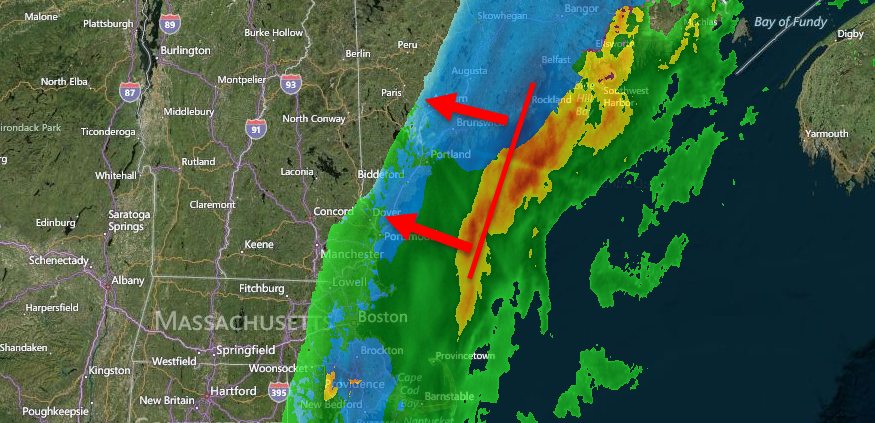
Right now, rain is already moving into parts of CT and RI for the trick-or-treaters. This is a little ahead of schedule and could have some

This storm will be divided into two parts. Part one arrives Saturday morning and lasts through Saturday evening. This will be primarily rain for our area and will involve NE winds of around 20mph gusting to 30mph. Winds during this time will be out of the NE. This is when the bulk of the QPF (the amount of liquid that will fall from the sky) will fall. After this low passes by, winds turn to the NW, precip slows and phase two begins.

Phase two involves the second low developing and passing offshore. Column saturation loss looks likely Saturday evening which should lead to precip becoming more drizzly in nature. Cold air will begin to flood southward at this point and begin to transition precip to snow. This is where the biggest forecast challenge lies. If the second low tracks more to the West, we get more QPF out of it but the snow line gets pushed farther west. If the storm passes farther east, there is less in the way of QPF but the snow line would make it farther south. This second low could even miss us altogether and bring flakes exclusively to the Midcoast.

Right now, it looks like the most likely scenario is that the first low delivers rain to most and snow to the high elevations while the second low passes farther offshore. I think most in Maine and New Hampshire see snow this evening with the most snow falling in Downeast Maine (over a foot is expected by NWS Caribou) tapering down to a few flakes flying over Southern and Coastal areas.

Snow map 10-31p2

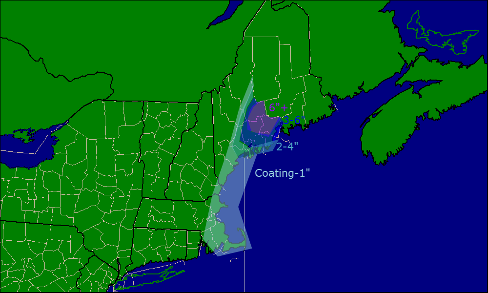
Snow map for Saturday and Sunday. Click to enlarge.

Winds will be a big issue as well as the storm rapidly intensifies. Expect the highest winds along the coast with gusts surpassing 50 mph at times especially Saturday night.

wind forecast

Peak wind gusts Saturday and Sunday. Click to enlarge.

I’ll be busy most of the day tomorrow but will likely have a mid-storm update tomorrow evening.

-Jack


Clouds increase ahead of weekend storm

Hello everyone!

Apologies for the late update, there was an unusual amount of data that had to be looked at this morning to come up with the forecast. Today will feature increasing clouds ahead of the storm. Weak warm air advection may bring a sprinkle or flurry to the mountains later in the day but otherwise, no interruptions for trick-or-treaters. Temps this evening will be falling through the 40’s.

today 10-31

As for tomorrow, models are slowly coming into better agreement in terms of how the storm will play out. The GFS is the most excited about the storm idea with the JMA not far behind. The Euro is still pretty excited but not nearly as much as the GFS. The NAM remains completely uninterested.

Here’s how I think it will play out. Top-down saturation of the column will allow for some light snow after midnight for the mountains. Rain moves in Saturday a little before noon at the coast and spreads NW throughout the early afternoon in association with the first low. Rain becomes more showery in nature for a brief time Saturday evening before picking up again Saturday night. Once night falls, cold air will start to flood south as the storm intensifies so a gradual change to snow can be expected starting in the mountains and eventually making it all the way to the coast by Sunday morning. All precip moves out Sunday midmorning.

snow map 10-31

Here’s my thinking on accumulations. Even heftier totals will probably fall in Downeast Maine.

Winds will be another issue as they would be anytime a storm rapidly deepens off the coast. Wind gusts will be strongest across coastal areas with gusts reaching 50mph at times. Sustained winds will be much lower however likely not making it out of the 30mph range. Power outages could be a big problem especially if snow happens to be on the branches when the wind is strongest (Saturday night).

Much cooler air moves in for Sunday with highs even at the coast not making it to 40.

-Jack