Tag Archives: forecast

Slushy Storm To Bring More Snow, Rain To The Area Tomorrow Into Sunday

Hello everyone!

Another storm is on the way this weekend and while much of the Northeast US sees rain and 40’s for this storm, we lucky Northern New Englanders will likely be seeing more snow. While this will not be a big storm by any means, especially compared to others this winter, it will put a temporary pause on the arrival of Spring.

Water Vapor Image From This Afternoon Showing The Two Features That Will Bring Snow To The Area This Weekend. Credit: SSEC

Looking at the setup for our weekend system, two main features present themselves: a plume of moisture and warm air heading north from the Gulf Of Mexico and an Arctic disturbance racing SE to meet the moisture. How much cold makes it south and how far it gets will be crucial to determining how much snow falls.

12Z GFS Valid At 1 PM Tomorrow Showing Warm Air Streaming In At 2500 Feet. Credit: Accuweather

Before precip even starts, SW winds aloft will be allowing warm air to stream into southern parts of the region resulting in very little snow on the front side of the storm. Winds aloft are far weaker inland and thus above freezing air should be mainly a coastal issue with the foothills briefly getting in on the action tomorrow afternoon.
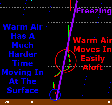
12Z NAM Showing Warm Air Working In Aloft But Staying Firm At The Surface. Vertical Temp Profile For Augusta, Valid At Midnight Tomorrow
12Z NAM Showing Warm Air Working In Aloft But Staying Firm At The Surface. Vertical Temp Profile For Augusta, Valid At Midnight Tomorrow. The Red Line Indicates The Temperature.

Warm air will also be working in at the surface but with 1-3′ of snowpack still on the ground, warming aloft may outpace the warming at the surface tomorrow morning so a brief period of sleet/freezing rain  is possible along the coast and just inland as well. While this doesn’t look like a major concern, watch out for some extra slick spots tomorrow morning.

12Z GFS Showing A Lack Of Intense Upward Motion Resulting In A Lack Of Heavy Precip. Image Credit: Accuweather

Another key difference between this storm and others this season will be that precip this time around will be a lot more on the steady side rather than extremely heavy. The GFS vertical velocity map above shows this well. Notice the lack of pinks/reds and the introduction of more gentle oranges. This translates to light to moderate precip rather than heavy precip.
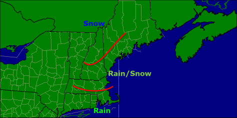
precip type map
Expected Precipitation Type For This Storm

By tomorrow afternoon, the warm air will have made its farthest push inland with temps both above freezing both aloft and at the surface all the way into the foothills. During the heaviest rain, flooding could be an issue along the coast where rain and snowmelt could combine to cause some minor street flooding Saturday afternoon/evening. Any impacts from flooding should be minor but it is something to watch for especially along the coast.

12Z GFS Showing A Strong Upper Low That Will Help To Extend Snow Well Into Sunday. Credit: Accuweather

The final phase of the storm will come Sunday as an upper low dives SE across the area. This will help to continue snow across the area on Sunday which is when coastal areas see most of their accumulations. Flakes will be flying as far south as SE MA but no accumulation is expected south of Boston.

12Z Canadian Model Showing Snow Lingering Into Sunday Afternoon. Map Valid 1 PM Sunday. Credit: Weatherbell

Snow on Sunday will be lighter and more showery in nature but it will help to keep roads slick and flakes falling for most of another day.

snow map 3-13

Taking a look at accumulations, the highest totals will be in the mountains where the cold air will hang tough the whole way through. Amounts drop off towards the coast with Southern New England seeing no accumulation at all.

I’ll have another update in the morning.

-Jack

Forecast for the next few days

Sadly, I do not see any big snow in our future. I do however see some light snow on sunday as a low passes well offshore. But first, let me get to today and saturday. Both days will be quiet weather wise. Today will feature slightly more of a westerly wind but nothing like yesterday. By saturday winds will of calmed down more. Both days feature sunny skies with a few fair weather clouds. Today there is a slight chance for a flurry or snow shower but the potential is small. Temperatures will be chilly with highs in the 20’s with lows getting down into the single digits.
-Jack

Suspicious Models…

In my roundup of morning model checks, I saw a something that interested me. It  was that 2 models predict that a storm, TD9, will impact us. They think that This storm will hit GA then traverse NC and VA then move back out over water and re strengthen before hitting Long Island and moving into the Gulf of ME. This would prove to be a cataclysmic scenario for most of the East coast. Fortunately this is not anticipated but something to watch…

STAY TUNED!!

-JAck

Quick update

Snow has arrived and will remain entrenched through the night. Cyclogenisis has begun and 2-4″ per hour snowfall rates will be common inland ( 15 miles inland from the coast.) and 3″ per hour rates at the coast though inefficient accumulation will lead to lesser totals. Thunder will be likely at the peak intensification time ( 10pm-2am)

Snow amounts stay the same.

-JAck


Rain on friday for the coast

Models have been tracking a little bit farther west and that means rain for the coast as well as some freezing rain and snow at the very beginning. Snow/mix/freezing rain will all change over to rain around daybreak. Inland will see snoe changing to mix/freezing rain around midday and Te mountains will see mostly snow with occaionial sleet mixing in. Amounts will go as following: Southern coast as well as the immediate middcoast and southern interior-1-2″ inland and midcoast and foothills-3-6″ Mountains and North 4-8″.

Stay tuned!

-JAck

Mild start to the week

It is a mild start to the workweek this week with a strong low pressure over the Great Lakes will track northward through Ontario and eventually Northern Quebec. This low will swing a warm front north through the area tonight bringing a period of light rain at the coast, and freezing rain or rain inland with possibly some snow changing to rain in the far north and mountains. Tuesday will be extremely mild with 50 degrees in Portland and Yarmouth anywhere north of that will see temps in the 40s except for the mountains where around 40 or a little under can be expected.

Mid Atlantic: Cold front Tuesday will bring cooler temps to the area and will bring a line of showers and t-storms Tuesday.

Stay tuned!

-Jack

Saturday Snow and Monday Night Rain

 Saturday across the Mid Atlantic will feature snow north of a Baltimore-Philidelphia- NYC line clearing for Sunday morning with a cooler Sunday for everyone. Our next storm will track throught the Mid Atlantic Sunday night trowing clouds across the Mid Atlantic Sunday ahead of the storm. Monday will feature rain for most of NE with some snow at the onset of precipitation as cold air is firmly in place.

Snow will start to move in tonight and will be over the area by dawn and moving northward through the day. North of Augusta ME will see no accumulations while anywhere north of Portland and south of Agusta will see around 1-3″ and York County will see 3-4″.  Seacoast NH will see 3-5″ and Boston North will see 3-5 due to some sleet possibly mixing in there.6-8″ in northern CT including Hartford and surrounding areas.

Sunday will feature some clouds for the Mid Atlantic out ahead of the next storm that will bring rain for the East Coast starting sunday night and then into monday and monday night lingering into tuesday for northern NE

Stay Tuned!

-Jack

Snowy stretch ahead for New England while Mid Atlantic Enjoys Mainly Quiet Weather

Overview: Strong low pressure will move swiftly out the mouth of the St Laurence and has already pushed a cold front through overnight. Strong winds will develop behind the front bringing in cold air. Winds will gust to close to 50 mph out of the W or possibly WNW or NW. Tomorrow will feature clouding skies and a lot less wind. Thursday night will bring a clipper system to the area developing a coastal low in the southern Gulf Of Maine. These two systems will bring close to 6″ to the midcoast and Central Maine with 4-5″ along the coastal plain ( the waterline to around 10 miles inland) with 2-4″ in the mountains 3-5 is likely in the far north. Saturday will feature a second clipper system and coastal low so the results will be very similar to that of the Thursday night storm. Monday will feature yet another storm and since the models diverge and the storm is in the long range forecast details are uncertain but we do think that as of right now it looks like a wintry mix along the coast with more snow inland.


Details: Winds will pick up as the day goes on peaking at around 9am with 50+ mph gusts and sustained winds peaking at around the same time at 25-30 mph. This wind will bring in colder air and will set the stage for two systems which will affect the area Thursday and Saturday nights.These two systems will bring close to 6″ to the midcoast and Central Maine with 4-5″ along the coastal plain ( the waterline to around 10 miles inland) with 2-4″ in the mountains 3-5 is likely in the far north. After that we will find a quiet and cold end to the weekend. Monday however will be different with temps at the coast in the mid 30s so at this point it looks like a tricky forecast and a mix at the coast.

Mid Atlantic: Windy today but winds will calm as the day goes on and become cooler. This cooler air will set the stage for some flurries for Thursday night although the southern sections will not get too much precipitation in the next week with Thursday and Saturday nights being the only two times precipitation in the southern sections. The northern sections however will get some more prolonged snow showers Thursday and Saturday nights which could leave a coating to an inch on grassy surfaces.

Stay tuned!

-Jack

Thursday storm update

Tuesday 6:00 pm: New updates coming in this evening showing that this storm will bring some welcome relief from the “snow drought” this season. This system will be a classic Nor’easter with a stiff NE wind throughout the day thursday. This NE wind will bring a possible mix at the immediate coast ( Islands and tips of peninsulas ) and southern sections of ME and NH. Early snowfall estimates go as following:      Coast………….3-6″
Inland………….4-8″
Mountains………….around 1′

Stay tuned!

-Jack

Thursday snow with a mix possible at the coast

Thursday has been a tricky forecast for the past several days but now the forecast has become more clear. The eventual type of precipitation is still uncertain and will depend on the actual track of the low. But we can eliminate some options. We can eliminate an all rain scenario for NE. Also we can eliminate an even partial snow scenario for the mid atlantic. It will be all rain there.

Stay tuned!!

-Jack