Tag Archives: freezing rain

A Messy Storm Tonight Into Tomorrow

Hello everyone!

Snow is moving into Southern New England this evening ahead of our next storm and snow will move NE into our area tonight. Snow mixes with and changes to freezing rain tomorrow morning before a lull tomorrow afternoon. The lull ends with heavy rain and wind Tuesday evening before we clear out and cool down Wednesday morning.

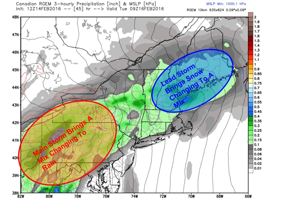
First Round: Frozen Medly

Evening Radar Showing The Setup For Tomorrow. Image Credit: Accuweather

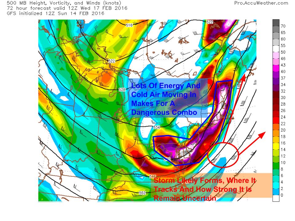
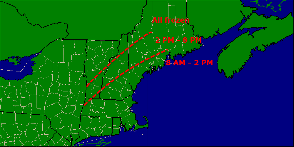
The general idea from Yesterday remains the same but with a few tweaks. Snow will move in from SW to NE this evening beginning around 7 in York County. Radar is indicating snow is falling across York County however with VERY dry air at the surface, I doubt this is making it to the ground. The ground is very cold and thus snow will accumulate quickly and efficiently once it starts falling.

2-15 graphic 2

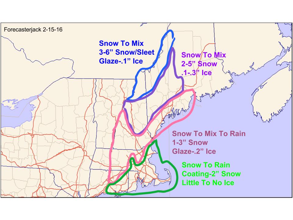
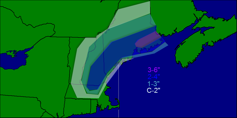
Snow will fall throughout the night tonight and will accumulate to 1-3″ before warm air aloft begins to change snow to ice around or a little after midnight. Along the coast and across the coastal plain, this is all the snow you’ll get. For inland areas, another inch or two is likely bringing total snow to 2-4″. The mountains hold on to snow the longest with 3-6″ of accumulation. While the mid levels of the atmosphere get torched by a 50kt+ Low Level Jet, the air right near the surface will remain cold as cold dense air settles to the surface. For this reason, expect freezing rain to be the dominant precip type tomorrow morning with some sleet mixed in towards route 2. This will lead to a VERY slippery morning commute with roads a total mess due to several inches of snow under some sleet under a layer of freezing rain.

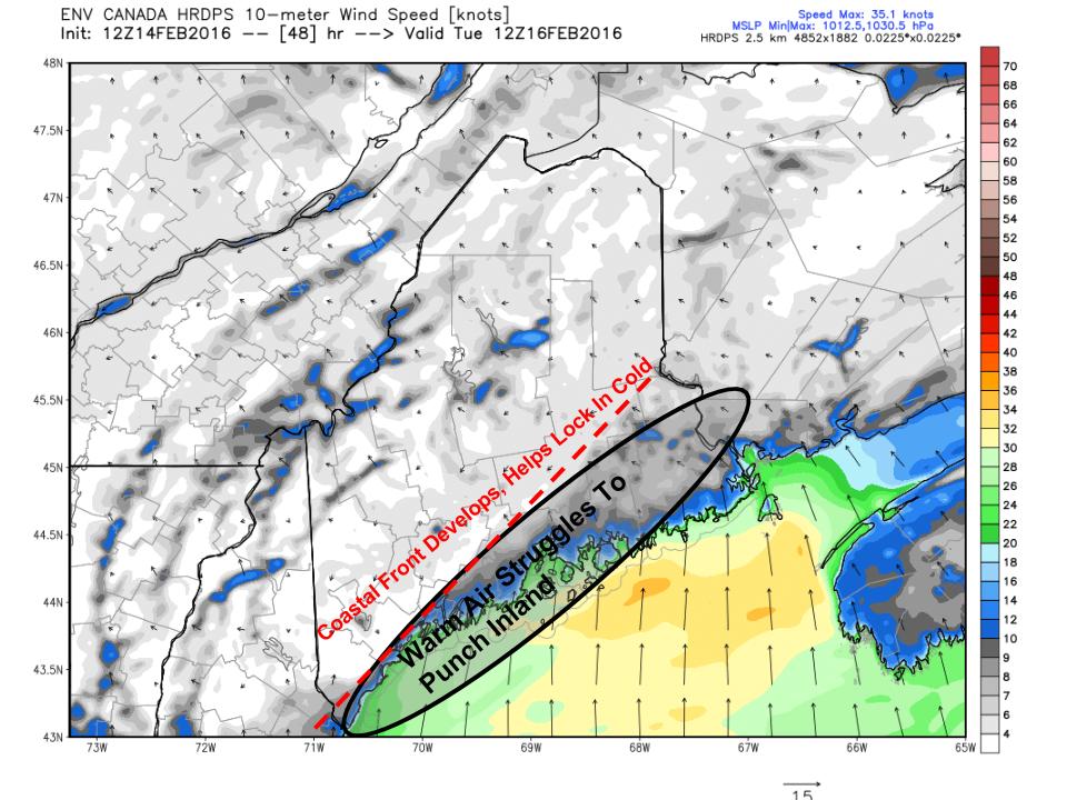
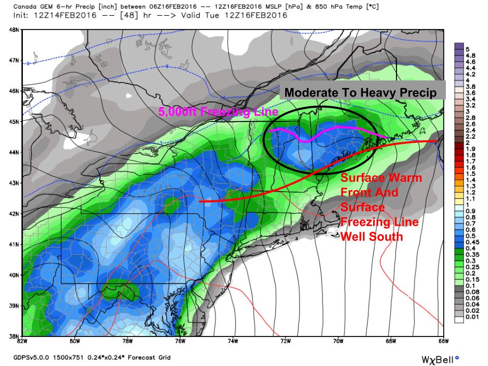
Second Round: Tropical Punch

2-15 graphic 3
18Z NAM Showing Very Strong Winds Aloft Tomorrow Evening. Image Credit: Accuweather

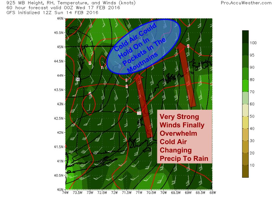
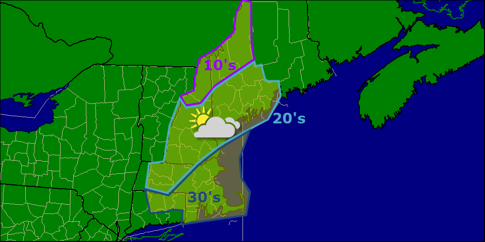
Freezing rain will continue through mid to late morning tomorrow before tapering to freezing rain showers as a dry slot briefly works in. During this time, the cold air will gradually be mixed out as southerly winds kick in. Precip will resume tomorrow evening as a cold front approaches. This round will be mainly rain except maybe for some isolated mountain valleys. Rain will be heavy at times and thunder is not out of the question as the cold front moves through. Winds will be gusty at this time as well with gusts over 40mph possible. Winds will be limited however by how much the cold air hangs on. The longer the cold hangs in, the more wind we see. Some power outages are possible during this time though significant impacts seem unlikely.

Rain moves out late tomorrow night with clearing and cooling expected Wednesday. More snow/rain is possible for Friday as a clipper system moves over the area.

-Jack

A Mess Of A Storm Tuesday

Hello everyone!

Low pressure will pass through the area in waves tomorrow night through Wednesday. The track of the main low will be to our west so this will be a snow to mix to rain event even in the mountains. Snow, freezing rain/ice, flooding, and wind threats with this storm. I’ll outline each below broken down by wave. The first wave is the cold phase of the storm with snow and mix while the second wave is almost all rain. There is a chance we see a third wave on Wednesday with more snow but that is far from certain. Let’s dig into the forecast.

The Setup

2-14 graphic 1
12Z RGEM Outlining The Major Players In Tuesday’s Storm. Image Credit: Weatherbell

Here is the RGEM model for Tuesday morning showing the major players. A storm is moving across the southern Ohio valley right now and will move into VA tonight. It will then move NE along a warm front and that will deliver our first shot of precip. Given how darn cold the air is out ahead of this storm, I am hesitant to jump at warm air blasting in without a fight. That being said, SW winds will have all of Monday to moderate the air before the storm even arrives. Also, the high pressure system containing the cold air will be retreating offshore which means it won’t be funneling cold air into the area through the event. Instead, counterclockwise winds around the high to our east will help promote strong southerly winds which will greatly help warm air coming north.

First Wave: Cold Air Hangs On

12Z HRDPS Showing How Cold Air Could Hang Tough Tuesday Morning. Image Credit: Weatherbell

The first wave of precip will arrive tomorrow night and will initially be in the form of snow. Several inches will accumulate by Tuesday morning and this will cause the Tuesday morning commute to be messy. Use extra caution and allow for extra time to get to work/school. The mesoscale higher resolution models such as the RGEM and HRDPS are holding the cold air in place much longer than the lower resolution global models. This is a good indication that cold air will hang on unusually long, as it almost always does in Maine in February after an Arctic blast with a solid snowpack on the ground. For those reasons, I am hesitant to believe fully that anyone but the immediate coast changes to rain before midday Tuesday. My time forecasting here has taught me never to underestimate the sticking power of Arctic air.

First Wave: Freezing Rain Threat

12Z GEM Showing Freezing Rain Potential Tuesday. Image Credit: Weatherbell

As the first wave moves through Tuesday, winds aloft will be blasting the area with a blowtorch, sending warm temps deep into the area. Cold air aloft is easy to displace. However, cold air at the surface doesn’t like to go anywhere in a hurry. The 12Z GEM shows this well. Tomorrow morning, the surface freezing line will hug the surface warm front offshore. The low level cold will dam along the mountains and will generally be sluggish in terms of going anywhere. In between the freezing line aloft and the freezing line at the surface, there is the risk for freezing rain. For the foothills, this could be a respectable freezing rain event with amounts of a tenth to as much as a third of an inch possible. Depending on exactly how much warm air moves in aloft and exactly where in the atmosphere it does, sleet is also possible. The mountains will remain cold enough for snow for most of this time as the upper level warmth won’t quite make it there in time for the first wave. The coast will likely see the surface warm front move just far enough inland to bring temps above freezing leading to rain.

First Wave: Accumulations

Snow map 2-14

Here’s what I’m thinking for accumulations for the first wave from tomorrow night through Tuesday evening. After Tuesday evening, everyone most likely changes over to rain as warm air streams in. This could be a significant enough icing event for the foothills to lead to scattered power outages especially if the inversion can break enough to allow for gusty winds with the second wave Tuesday night. Most of this is washed away Tuesday night with the rain but it will be quite slippery for both the AM and PM commutes Tuesday the more so the farther inland you go.

Second Wave: Cold Air Washed Out

12Z GFS Showing Strong Winds Just Above The Surface Pumping Warm Air Into The Area. Image Credit; Accuweather

After the first wave departs early Tuesday afternoon, we will see a lull in the action before the main storm passes well west of the area. The initial wave will help lift the warm front north of the region and warm air will begin to stream into the entire area. By the time round two arrives Tuesday evening, almost everyone will be warm enough for rain. Winds will become quite strong out of the south and south east aloft and there is the risk that some of those gusts mix to the surface in some capacity though a strong inversion will keep the serious winds mainly to our south. Especially along the coast though there is the risk for gusts up to 35mph. The warmer your temperature, the higher your risk for winds which is why the coast is at the greatest risk for wind. The mountains and especially the mountain valleys do an exceptionally good job holding on to cold air and I wouldn’t be surprised to see some mountain spots hold on to some variety of frozen precip throughout the whole event. The farther north and west you go the more likely this is. A general .5 to 1″ of rain is expected with this event which could lead to isolated flooding with frozen ground and a little snowpack.

Third Wave: Surprise Snow Wednesday?

12Z GFS Showing A 500mb Setup That Is Dangerous For Surprise Snow Wednesday. Image Credit: Accuweather

The rain moves out quickly Tuesday night and cold air moves back in for Wednesday. Another storm is right on the heels of this one but right now the thinking is it stays south. However, the 500mb setup pictured is dangerous for surprise snow with a long nose of energy pointed right at us. Most likely a storm forms and models are currently thinking it heads well south but I’m not fully convinced yet. Even without a robust surface storm, trouble could still be caused by upper level energy. It is also possible enough dry air moves in behind the rain that we don’t get anything. We’ll have more clarity on this once we figure Tuesday out which might just be on Tuesday.

A period of cool calm weather arrives Thursday into Friday and another storm threatens for Saturday with a mix of snow and rain likely.

-Jack

Full update on multi-day Nor’easter

Hello everyone!

Today will feature a very active weather day as our storm beginning to impact us. Already radar indicates light to moderate snow/sleet/freezing rain along coastal areas as the coastal front gets defined. Expect very slippery travel especially on untreated roads.

There are lots and lots of watches/warnings/advisories up for the area so PLEASE click over to the NWS Gray website to get the full scoop on those.

cf

Here is a snapshot of current conditions. Notice the sharp difference between 40’s and an east wind and 20’s and a north wind. This is the rain/frozen line so when it moves ashore, all rain is ahead for areas to the east of it. After seeing the past two frozen precip events where warm air has struggled to overcome a cold wedge, I can easily see where freezing rain hangs out a little longer than expected, even a the coast.

Snow/sleet/freezing rain will change to rain at some point this morning at the coast with islands and the tips of the peninsulas going first between 7 and 9, with most of the rest of the coast switching between 8 and 10 with the exception of sheltered interior bay areas who could hold out until 11 or 12. Everyone at the coast looks to be liquid after noon.

While frozen precip moves out this morning, the coast is not out of the woods just yet overall. Expect very heavy rain this afternoon into tonight accumulating 1-4″ in total. The rain will be fiercely windswept with 20-30mph sustained winds and gusts nearing, or sometimes exceeding, 60. With this kind of wind plus a thawing and highly saturated ground, coastal areas should be prepared for numerous power outages.

While the coast deals with wind and rain, inland areas get treated to more ice and snow. Expect snow and ice through at least 1 PM for areas 20 miles or so from the coast with inland/foothill areas taking until later on this evening to fully turn to liquid.

switch times

Once you turn to rain, you’re all rain until the next round moves in Wednesday. The mountains should stay all frozen but that doesn’t mean all snow. Expect a period of sleet and freezing rain in addition to very heavy snow. Heavy wet snow in combination with ice and 20-40 mph winds will likely lead to lots of power outages for the mountains.

power outage threat


I have highlighted two areas for a high risk of power outages, the coast and the mountains. For the coast, the ground will thaw today and become very saturated with all the rain falling and when you combine that with very strong wind gusts, the power outage threat is real.

The mountains also see a high risk for power outages because despite weaker winds, several inches of snow plus some ice will make for a high threat of power outages. Everyone should be prepared but the risk this time around is focused on the coast and in the mountains.

Snow will be a big issue in the mountains this time around as cold air hangs tough and heavy precip moves in. This will be a heavy, backbreaking type snow and along with ice and sleet will be a real nightmare to get rid of.

Snow map 12-9

This map is valid through Friday (or whenever the storm decides to leave). I’m still trying to get a better sense of how the backside snow plays out but the coast should pick up at least some accumulations. I’ll have more details in later posts regarding the backside snows.

Coastal flooding is the final impact that needs to be talked about. With a prolonged period of intense onshore winds, water tends to pile up along the shore. NWS Gray has issued a coastal flood statement for the coast for this reason. While impacts should be minor, some splashover and beach erosion is likely. The greatest impacts will be today’s high tide at 1240 and tomorrow morning’s high at 1:18.

I’ll try to be back this evening with a mid-storm update but if that doesn’t work out, I’ll be back tomorrow morning.

-Jack


Frigid this morning, major storm coming tomorrow

Hello everyone!

Today will feature frigid conditions area-wide with current readings as of 5 AM ranging from 32 on Nantucket to -15 near Moosehead lake. Temps will warm up today and especially tonight as warm air advection becomes stronger. Ocean effect snows are likely over coastal Maine and New Hampshire however accumulations should be minimal. Highs today will be very chilly as well ranging from the 10’s north to 30’s south.

today 12-8

Overall, clear skies are expected in the morning with clouds overspreading the region as the day goes on.

All in all, the storm forecast looks pretty good. This looks to be the type of situation where a degree or two and only a handful of miles makes the difference between 12″ and 2. This battleground looks to set up over the northern foothills tomorrow with the mountains seeing snow/sleet/ice and the southern foothills/coast seeing rain.

However, before that, early on Tuesday morning, it looks like everyone sees a period of light snow, sleet, or freezing rain with snow to freezing rain being the favored scenario for the coast Tuesday morning. After 9 or 10 AM, the coast looks to go to all rain and the switch could happen before then.

It is important to note, however, that we have deep cold air in place as this storm approaches so it may be hard for the warm air to scour out all the low level cold. This is the reason that freezing rain may be a widespread problem Tuesday morning. Combine this with a little snow and sleet from earlier in the morning, and you have a very slippery AM commute for all of Maine and the northern half of NH.

Any precip before 1PM or so Tuesday will be on the lighter side so no significant accumulations are expected despite the timing making for a slick AM commute. Heavier precip moves in the afternoon by which time the coast will be warm enough for all rain.

By midday Tuesday, we have the storm in full force with winds gusting over 50mph at the coast accompanied by driving rain and a heavy, wet snowstorm over the mountains. Expect the peak of the storm to arrive Tuesday evening and heavy precip will linger into Wednesday Morning.

Even as the surface system weakens and precip associated with it moves out, we are still stuck with the upper low. The upper low looks to meander near Cape Cod or maybe a bit farther north for several days which means that wrap around moisture combined with lift associated with the UL would bring continued precip, both liquid and frozen, to the area through Thursday.

Beyond that, the forecast really depends on how fast the UL gets out of here. The Euro has it hanging around through the weekend with another storm Saturday while the GFS shoots it out into the ocean Thursday bringing clear conditions for the weekend.

I’ll have another update this evening.

-Jack

More snow today, warm-up tomorrow

Hello everyone!

Today will feature more snow and possibly mix/rain at the coast. Precipitation should move in mid afternoon and will remain light/moderate over Southern Maine and New Hampshire. As the low deepens, snow will increase in intensity over Downeast sections.

Snow map 2-19


Snow map.

Temps today will be in the low 30’s inland and low to mid 30’s at the coast. Rain/snow will move out this evening into tonight.

Freezing rain will take hold of the area Thursday night into Friday morning before turning to all rain. This will make for a VERY slippery morning commute Friday especially with some towns dealing with a salt shortage.

Cold air returns with some light snow Sunday. Cold air will be firmly locked in next week and the threat of a coastal storm will be there all next week though there is no specific threat as of now.

-Jack

Rain on friday for the coast

Models have been tracking a little bit farther west and that means rain for the coast as well as some freezing rain and snow at the very beginning. Snow/mix/freezing rain will all change over to rain around daybreak. Inland will see snoe changing to mix/freezing rain around midday and Te mountains will see mostly snow with occaionial sleet mixing in. Amounts will go as following: Southern coast as well as the immediate middcoast and southern interior-1-2″ inland and midcoast and foothills-3-6″ Mountains and North 4-8″.

Stay tuned!

-JAck

Wet and unsettled beginning to the workweek

As most of us are enjoying the long weekend ( myself included! ) There will be an unsettled beginning to the workweek. A system from the midwest will move in tonight with snow. Warmer air works in at around 9-11 am and we will see a mix with sleet and freezing rain  and eventually rain at the coast and will work inland from there.

Stay tuned!

-Jack

Snowy update

UPDATE: 1:45pm EST curent observations show a bout 4″ have already fallen here in Yarmouth with higher totals WSW of here. Another 4-8″ is expected bringing the forecast totals to a little less than a foot at the coast with higher amounts inland and in the mountains. Temperatures will warm to about 31 before dropping. Tonight will feature freezing rain amounting to around .15-.25″ travel will be tricky if not outright dangerous until around 3:00 tomorrow.

Stay tuned!

-Jack

Winter storm tomorrow

Wednesday 5:00: Forecasts have shifted dramatically this past week. Just 1 week ago the forecast was 50 and rain, now it is 33 and snow with freezing rain for Friday. There is some tricky parts in the forecast though. It looks like there will be a strong temperature difference between about 100 yards from the shore where the high will be around 32 or 33 and snow while even 100 yards offshore where highs will be in the upper 30s and rain. Amounts: islands and tips of peninsulas……………1-3″  Coast ( within about 1 mile of the water ) 4-6″   inland  8-12″ and mountains……………..7-9″. More updates in coming hours.

Stay tuned!!!

-Jack

Tricky forecast for friday

Friday will feature clouding skies with precipitation starting around 3-4pm. But the tricky part is precipitation type. Ice, snow, or rain??

Stay tuned!

-Jack


Make your predictions here: