Tag Archives: Maine

Complex Winter Storm Moves In Today

Hello everyone!

Today will be an interesting one region wide as our storm moves in. Expect light wintery precip across Maine and New Hampshire this morning with some light accumulations possible. Heavier precip moves in tonight, mainly in the form of rain, before wrapping up Monday morning as snow for some mountain areas.

This Morning

South of Route 2 and away from the immediate coast, the dominant precip type this morning will be freezing drizzle.  A trace of ice is likely and a freezing rain advisory has been issued. Thankfully for the major ski areas in Maine (Sunday River, Saddleback, and Sugarloaf), this morning’s precip will be mostly in the form of snow with up to 2″ possible. A strong coastal front will keep the coast out of the woods for the freezing rain threat as temps will rapidly warm there once the front moves inland slightly.

As for Southern New England, far western MA and CT could see some freezing drizzle that could accumulate to a trace or so and areas away from the coast could see road temps lag enough for some slick spots this morning. Bottom line: travel will not be treacherous but could be slick in spots this morning. The freezing drizzle/snow does not arrive in Maine until after 9AM or so while SNE starts the fun a little earlier.

This afternoon

Light and somewhat scattered precip this morning will give way to steadier precip by this afternoon. Again, location will be the key for precip type as the coastal front begins to collapse westward. By around 4 this afternoon, the rain line should be near Paris extending back toward Lewiston and will be rapidly moving NW. Freezing drizzle and snow will continue in the mountains through the afternoon. Heavier precip will begin across southern New England and move NE this afternoon reaching Maine between 4 and 9PM depending on location.

This evening

Heavy rain for almost everyone tonight with the exception of far NW NH. SE winds will become very strong at the coast and could gust over 40 mph at times this evening. Since the low will track basically right over the NH/ME line, NW NH will remain on the cold side of the storm so all snow and sleet is expected there. A general .75-1.5″ of rain is likely with some of the hillier foothills possibly seeing 2″. 3-6″ of snow and sleet is likely for the parts of NH that stay all snow/sleet with 1-3″ for the rest of the ME mountains. With warm air flooding in at the surface, the higher peaks will stand the best chance for seeing snow.

Tomorrow morning

As the low moves NE and strengthens, the cold air will again collapse, this time to the SE and will race the dry slot to change the foothills back to snow before the precip ends. In the mountains, especially the western mountains, the cold air will have no problem beating the dry air and an additional 1-3″ is likely for the ME mountains. Keep in mind, over an inch of rain will have fallen since the last 1-3″ this morning so 6″+ is unlikely for most Maine areas. The summits of Sugarloaf and Saddleback could be the exceptions as their elevation will put them above several warm layers today.

All precip will come to an end by tomorrow afternoon as strong west winds bring in dry air. Westerly winds will be very strong both Monday and Tuesday gusting at times over 40mph due to intense cold air advection. As a result of the cold air advection, falling temps can be expected Monday with highs occurring in the morning hours. Temps will already be cold Tuesday and will rebound some but will still be falling most of the day.

-Jack

Evening update on disruptive pre-Thanksgiving storm

Hello everyone!

Winter storm warnings and winter weather advisories are flying for large parts of the area this evening ahead of a majorly disruptive pre-thanksgiving storm.

warnings 11-25

For more details please visit the NWS website.

Last blog update today and we do have some important things to talk about. First off, this is a very hard forecast especially for coastal Maine. Our main problem continues to be a warm layer at roughly the 650mb level (high high up there) that will tamper with the formation of snowflakes. When temperatures are too warm at this level, snowflakes have a hard time forming. this can result in icier snowflakes, or columns as they’re called, falling from the sky. This can be a problem as far as accumulations go because these types of flakes are much harder to accumulate than normal flakes.

In addition to our snow growth problem, we have a very warm ground in place from two days in the 60’s which will make accumulations harder. Also, the event will start as a period of rain before changing over to snow which will further warm and thaw the ground. With a warm and wet ground in place to start the event, I can easily see accumulations being cut down especially at the coast. This will also be a very heavy, wet snow so we have basically an anti-fluff factor working against us. With compaction and melting, should the coast flip to rain at some point, I can easily see how you will end up with less snow on your car than you may have seen on a map. For this reason, I have trimmed back totals a little bit at the coast. I think that inland areas should have no problem with snow growth and the snow will be a tad drier there as well.

snow map 11-25v3

Should temps be a little chillier at 650mb or the switch to snow happen a little faster, coastal areas could pick up more snow. Should a warm layer work in aloft and the coast flips to sleet or columned snowflakes, totals go down. That is why I have highlighted coastal Maine as ‘extra low confidence’. That’s not to say I am super confident about the rest of the area, I just want to put it out there that bust potential is high.

I will be back tomorrow morning with another update. This will be a now-casting type of event so I encourage you to follow me on Twitter for the latest updates and forecast tweaks tomorrow as things unfold.

In my post earlier today, I went over the timing and impacts in great detail. I will copy and paste that below because it remains unchanged.

FROM EARLIER TODAY:

Timing:

Wednesday AM: The calm before the storm. Quiet conditions, no travel impacts. Generally cloudy across the area.

Wednesday Midday: Light snow starts in SNE and works its way north. By 1PM or so, Portland Maine should be in on the snow but not much farther north. Immediate coastal Maine will start as rain for about 10-15 minutes before wet bulbing takes over and cools things off. Once precip starts, expect mostly snow to fall. Travel impacts: Light to moderate

Wednesday PM: Precip has overtaken all of the area. Snow is falling heavily across interior SNE with rain along the coasts of RI and MA and mixing along the NH coast. Maine is pretty much all snow after this. Heavy snow bands should work their way north during this period. Travel impacts: Moderate to high.

Wednesday evening: The height of the storm. Heavy snow is falling over interior SNE with the snow line collapsing towards the coast. Maine is experiencing heavy snow as well. Mixing in NH should change to snow during this time. Cape Ann MA and SE MA remain all rain. Travel impacts: High to very high.

Wednesday night/wee hours of Thursday AM: Calming down. Heavy snow has moved into ME and all precip is ending across SNE. Rain should change over to snow for almost everyone, excluding the cape, for at least a brief time before precip ends. Travel impacts: High becoming moderate

Thursday AM: All done. Snow has moved into eastern ME but slick spots will still be around as temps will fall below freezing for everyone. Even those who saw rain could see puddles freeze up. Airports will also be clogged up with delays due to ripple effects from the storm. Travel impacts: Light (still high for airports).

Other impacts: 

SREF Model IDEA of probability of visibility <1mile.
SREF Model IDEA of probability of visibility <1mile. Valid 7PM Wednesday

Winds gusting over 30mph at times will cause blowing snow and reduced visibilities especially in heavy snow bands. Watch out for harsh road conditions in any of the areas shown in Red, Orange, or Pink in the maps above. While that is just one model, I think it lines up nicely with the forecast.

GFS model IDEA on windspeeds for 7 PM Wednesday. Note, speeds in Knots not MPH.
GFS model IDEA on wind speeds for 7 PM Wednesday. Note, speeds in Knots not MPH.

Winds will be an issue as well cranking over 30mph at times. This combined with over 6″ of heavy wet snow for lots of areas leads to an enhanced risk for power outages.

-Jack

High impact storm to slow travel on busiest day of the year

Hello everyone!

Busy day in the weather world today as a high-impact storm gets ready to move up the coast on the busiest travel day of the year. Below I will  highlight impacts, timing, and what might go wrong and why.

All the players are on the field so to speak right now as energy is diving south across the plains (the kicker energy) and more energy is rising up through the GOM. The interaction between these two peices of energy will be key in determining where the heaviest snow sets up.

players on the field
WV Imagery shows energy over SE US as well as over the Rockies

Water Vapor imagery clearly shows our developing storm system over the SE US as well as the energy diving into the plains states that will help to guide the storm up the coast.

Timing:

Wednesday AM: The calm before the storm. Quiet conditions, no travel impacts. Generally cloudy across the area.

Wednesday Midday: Light snow starts in SNE and works its way north. By 1PM or so, Portland Maine should be in on the snow but not much farther north. Immediate coastal Maine will start as rain for about 10-15 minutes before wet bulbing takes over and cools things off. Once precip starts, expect mostly snow to fall. Travel impacts: Light to moderate

Wednesday PM: Precip has overtaken all of the area. Snow is falling heavily across interior SNE with rain along the coasts of RI and MA and mixing along the NH coast. Maine is pretty much all snow after this. Heavy snow bands should work their way north during this period. Travel impacts: Moderate to high.

Wednesday evening: The height of the storm. Heavy snow is falling over interior SNE with the snow line collapsing towards the coast. Maine is experiencing heavy snow as well. Mixing in NH should change to snow during this time. Cape Ann MA and SE MA remain all rain. Travel impacts: High to very high.

Wednesday night/wee hours of Thursday AM: Calming down. Heavy snow has moved into ME and all precip is ending across SNE. Rain should change over to snow for almost everyone, excluding the cape, for at least a brief time before precip ends. Travel impacts: High becoming moderate

Thursday AM: All done. Snow has moved into eastern ME but slick spots will still be around as temps will fall below freezing for everyone. Even those who saw rain could see puddles freeze up. Airports will also be clogged up with delays due to ripple effects from the storm. Travel impacts: Light (still high for airports).

Accumulations:

snow map 11-25v2

As confidence has increased regarding moisture/presence of cold air, 10-14″ zone was added. I still think midcoast Maine mixes a little bit and wetter snow overall holds down totals generally along coastal Maine. That being said, I still think that with lots of upward motion and dynamic cooling, the coast can do well in this storm.

Other impacts: 

SREF Model IDEA of probability of visibility <1mile.
SREF Model IDEA of probability of visibility <1mile. Valid 7PM Wednesday

Winds gusting over 30mph at times will cause blowing snow and reduced visibilities especially in heavy snow bands. Watch out for harsh road conditions in any of the areas shown in Red, Orange, or Pink in the maps above. While that is just one model, I think it lines up nicely with the forecast.

GFS model IDEA on windspeeds for 7 PM Wednesday. Note, speeds in Knots not MPH.
GFS model IDEA on wind speeds for 7 PM Wednesday. Note, speeds in Knots not MPH.

Winds will be an issue as well cranking over 30mph at times. This combined with over 6″ of heavy wet snow for lots of areas leads to an enhanced risk for power outages.

More updates on Twitter this afternoon @JackSillin and I’ll be back on here with another update this evening.

-Jack


Advisory #2 on new Nor’easter

The next storm the east coast will be facing will be a very bad storm for Sandy ravaged areas. This storm will likely bottom out at 990mb slightly weaker then estimates from this morning and a day ago. These estimates suggested pressures of near 980mb. Regardless of pressures, this will be a very bad storm for all ravaged by Sandy. Winds of 35-50mph will ravage areas hit hard by Sandy. Models are trending east with this storm which means that there will be cool air in place in Maine allowing for some snow possibly accumulating to a few inches in mountainous areas. areas closer to the coast may see up to 1″. Accumulations will be tricky to forecast here due to the fact that the ground is warm and it will be a while for the ground to cool off enough to allow for snow to accumulate. 1-2″ of rain will be common from northern NJ to Cape Cod and possibly Seacoast NH.

-Jack

Afternoon update: storm moving ashore now in NJ, Battery park; other low-lying areas brace for historic flooding

Now this is crunch time. The center of circulation is bearing down on the NJ coast and the winds are picking up here in Maine.

Rain is now moving into the Detroit area now and is continuing steadily in most of the mid-atlantic states.

Forecasts are now holding steady and true (see posts below) and so I will not elaborate too much here.

New update from NHC:
NW movement at 28mph
pressure 940mb
winds 90mph

Hunker down and stay safe!

-JAck

New Models Show Less Impacts in Maine While Mid-Atlantic Sates Get Hit Hard

New models out this morning show Sandy/Frankenstorm making landfall in Centeral NJ Monday evening. This would deliver quite a surge to theNYC area. Surge heights would be on the order of 6-10′. Irene, for example, delivered a 4-5′ surge and missed flooding the subways by mere inches. With 5 extra feet of water and waves already on the order of 8′ in New York Harbor, subway flooding is a real possibility.

Station 44065 NDBC
Location: 40.369N 73.703W
Date:Sun, 28 Oct 2012 10:50:00 UTC

Winds: NNE (30°) at 21.4 kt gusting to 25.3 kt
Significant Wave Height: 8.5 ft
Dominant Wave Period: 12 sec
Mean Wave Direction: SSE (153°)
Atmospheric Pressure: 29.82 in and falling
Air Temperature: 58.3 F
Dew Point: 53.1 F
Water Temperature: 61.9 F
Bouy data from the entrance of New York Harbor.

For those of us who this means nothing to, there are only a few things that are important, 1) Significant Wave Height. This is simple and self-explanitory. How high the waves are above the average water level (excluding tides. Ex: 12 foot waves with a 2 foot surge would be reported as a Sig. Wave Height of 12 not 14). 2) Dominant Wave Period. This shows how powerful the blast of energy creating the wave is. The higher the number in seconds, the more powerful the wave (Ex: a wind blown chop has a 2 second period while a tsunami wave has a 5-8 minute period). 3) The obvious wind and pressure to show the weather in general.

Station 41002 NDBC
Location: 31.862N 74.835W
Date:Sun, 28 Oct 2012 10:50:00 UTC

Winds: NNW (330°) at 36.9 kt gusting to 46.6 kt
Significant Wave Height: 20.0 ft
Dominant Wave Period: 10 sec
Mean Wave Direction: NE (36°)
Atmospheric Pressure: 28.73 in and rising rapidly
Air Temperature: 75.6 F
Water Temperature: 77.7 F

Bouy data from 225 Miles SE of Cape Hatteras.

As you can see by the green Barometric pressure line, the storm center has already pass by though impacts are still severe.

Impacts will be lessened here in Maine due to the storm’s eastern band falling apart. This means that there is not heavy storm on the right hand side of the system. Dont let your gaurd down though…  The storm could easily at any moment decide to build a formidible eastern side or just as easily decide not to. Stay tuned!

Morning Satellite shot of Frankenstorm. As you can see the eastern half is fairly bleak sparing much of Northern New England

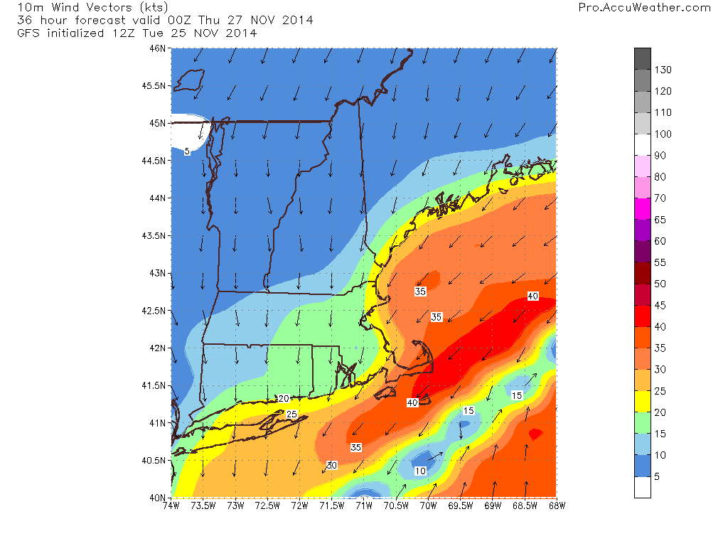
Winds will be in the 30-60ph range peaking Monday. This is for Maine and New Hampshire. 40-65mph for Massachussets. 50-70mph for Rhode Island. 60-80mph for New Jersey where the center of the storm moves in. 70 mph for NYC and Long Island. 50-70mph for much of MD with 45-60mph in far western regions. 35-55mph for Eastern VA with 25-45mph for Western regoins.

Tides will be running 2-4′ above normal due to surge in Maine and 1-3′ above normal due to the full moon. This will cause low-lying areas in Portland to flood. These areas will be along low-lying commercial street and areas adjecent to Back Bay as well as anywhere else that is less than 5-6′ above sea level.

Sandy is currently a Category 1 storm with top winds of 75mph. Below is the full NHC advisory.

…SANDY EXPECTED TO BRING LIFE-THREATENING STORM SURGE FLOODING TO THE MID-ATLANTIC COAST…INCLUDING LONG ISLAND SOUND AND NEW YORK HARBOR… …WINDS EXPECTED TO BE NEAR HURRICANE FORCE AT LANDFALL…


8:00 AM EDT Sun Oct 28
Location: 32.1°N 73.1°W
Moving: NE at 10 mph
Min pressure: 951 mb
Max sustained: 75 mph

This is the data and here is the full write-up. For more info including graphics, go to the nhc home page which can be found at the right of my page.

000
WTNT33 KNHC 281159
TCPAT3

BULLETIN
HURRICANE SANDY INTERMEDIATE ADVISORY NUMBER  24A
NWS NATIONAL HURRICANE CENTER MIAMI FL       AL182012
800 AM EDT SUN OCT 28 2012

…SANDY EXPECTED TO BRING LIFE-THREATENING STORM SURGE FLOODING TO
THE MID-ATLANTIC COAST…INCLUDING LONG ISLAND SOUND AND NEW YORK
HARBOR…
…WINDS EXPECTED TO BE NEAR HURRICANE FORCE AT LANDFALL…

SUMMARY OF 800 AM EDT…1200 UTC…INFORMATION
———————————————-
LOCATION…32.1N 73.1W
ABOUT 260 MI…420 KM SE OF CAPE HATTERAS NORTH CAROLINA
ABOUT 395 MI…635 KM E OF NEW YORK CITY NEW YORK
MAXIMUM SUSTAINED WINDS…75 MPH…120 KM/H
PRESENT MOVEMENT…NE OR 40 DEGREES AT 10 MPH…17 KM/H
MINIMUM CENTRAL PRESSURE…951 MB…28.08 INCHES

WATCHES AND WARNINGS
——————–
CHANGES WITH THIS ADVISORY…

NONE.

SUMMARY OF WATCHES AND WARNINGS IN EFFECT…

A TROPICAL STORM WARNING IS IN EFFECT FOR…
* CAPE FEAR TO DUCK NORTH CAROLINA
* PAMLICO AND ALBEMARLE SOUNDS
* BERMUDA

HIGH WIND WATCHES AND WARNINGS FOR HURRICANE-FORCE WINDS ARE IN
EFFECT FOR PORTIONS OF THE MID-ATLANTIC STATES.  OTHER WATCHES AND
WARNINGS ARE IN EFFECT FOR MUCH OF NEW ENGLAND. SEE STATEMENTS FROM
LOCAL NATIONAL WEATHER SERVICE FORECAST OFFICES.

FOR STORM INFORMATION SPECIFIC TO YOUR AREA IN THE UNITED STATES…
INCLUDING POSSIBLE INLAND WATCHES AND WARNINGS…PLEASE MONITOR
PRODUCTS ISSUED BY YOUR LOCAL NATIONAL WEATHER SERVICE FORECAST
OFFICE. FOR STORM INFORMATION SPECIFIC TO YOUR AREA OUTSIDE THE
UNITED STATES…PLEASE MONITOR PRODUCTS ISSUED BY YOUR NATIONAL
METEOROLOGICAL SERVICE.

DISCUSSION AND 48-HOUR OUTLOOK
——————————
AT 800 AM EDT…1200 UTC…THE CENTER OF HURRICANE SANDY WAS LOCATED
NEAR LATITUDE 32.1 NORTH…LONGITUDE 73.1 WEST. SANDY IS MOVING
TOWARD THE NORTHEAST NEAR 10 MPH…17 KM/H…AND THIS GENERAL
MOTION IS FORECAST TO CONTINUE THROUGH TODAY.  A TURN TOWARD THE
NORTH AND THEN NORTHWEST IS FORECAST ON MONDAY.  ON THE FORECAST
TRACK…THE CENTER OF SANDY WILL MOVE PARALLEL TO THE SOUTHEAST
COAST OF THE UNITED STATES TODAY AND TONIGHT…AND APPROACH THE
COAST OF THE MID-ATLANTIC STATES BY MONDAY NIGHT.

MAXIMUM SUSTAINED WINDS ARE NEAR 75 MPH…120 KM/H…WITH HIGHER
GUSTS.  LITTLE CHANGE IN STRENGTH IS FORECAST DURING THE NEXT
COUPLE OF DAYS…AND SANDY IS EXPECTED TO BRING HURRICANE-FORCE
WINDS TO PORTIONS OF THE MID-ATLANTIC STATES.

HURRICANE-FORCE WINDS EXTEND OUTWARD UP TO 175 MILES…280 KM…FROM
THE CENTER…AND TROPICAL-STORM-FORCE WINDS EXTEND OUTWARD UP TO
520 MILES…835 KM. A SHIP LOCTAED ABOUT 100 MILES SOUTH OF
MOREHEAD CITY NORTH CAROLINA RECENTLY REPORTED SUSTAINED WINDS NEAR
HURRICANE FORCE. ALSO…NOAA BUOY 41036…LOCATED IN ONSLOW BAY
NEAR THE NORTH CAROLINA COAST…RECENTLY REPORTED SUSTAINED WINDS
OF 47 MPH…76 KM/H…AND A WIND GUST OF 59 MPH…94 KM/H.

THE MINIMUM CENTRAL PRESSURE RECENTLY REPORTED BY NOAA AND AIR FORCE
RESERVE HURRICANE HUNTER AIRCRAFT WAS 951 MB…28.08 INCHES.

HAZARDS AFFECTING LAND
———————-
WIND…TROPICAL STORM CONDITIONS ARE SPREADING ACROSS THE COAST OF
NORTH CAROLINA IN THE TROPICAL STORM WARNING AREA…AND THESE
SHOULD CONTINUE THROUGH TODAY.  GALE FORCE WINDS ARE EXPECTED TO
ARRIVE ALONG PORTIONS OF THE MID-ATLANTIC COAST LATER TODAY…AND
REACH LONG ISLAND AND SOUTHERN NEW ENGLAND BY MONDAY MORNING. WINDS
AT OR NEAR HURRICANE FORCE COULD REACH THE MID-ATLANTIC STATES…
INCLUDING LONG ISLAND…BY LATE MONDAY.

STORM SURGE…THE COMBINATION OF AN EXTREMELY DANGEROUS STORM SURGE
AND THE TIDE WILL CAUSE NORMALLY DRY AREAS NEAR THE COAST TO BE
FLOODED BY RISING WATERS. THE WATER COULD REACH THE FOLLOWING
DEPTHS ABOVE GROUND IF THE PEAK SURGE OCCURS AT THE TIME OF HIGH
TIDE…

NC SOUTH OF SURF CITY…1 TO 3 FT
NC NORTH OF SURF CITY INCLUDING PAMLICO/ALBEMARLE SNDS…4 TO 6 FT
SE VA AND DELMARVA INCLUDING LOWER CHESAPEAKE BAY…2 TO 4 FT
UPPER AND MIDDLE CHESAPEAKE BAY…1 TO 2 FT
LONG ISLAND SOUND AND RARITAN BAY INCLUDING NEW YORK HARBOR…6 TO
11 FT
ELSEWHERE FROM OCEAN CITY MD TO THE CT/RI BORDER…4 TO 8 FT
CT/RI BORDER TO THE SOUTH SHORE OF CAPE COD INCLUDING BUZZARDS
BAY…3 TO 5 FT

SURGE-RELATED FLOODING DEPENDS ON THE RELATIVE TIMING OF THE SURGE
AND THE TIDAL CYCLE…AND CAN VARY GREATLY OVER SHORT DISTANCES.
GIVEN THE LARGE WIND FIELD ASSOCIATED WITH SANDY…ELEVATED WATER
LEVELS COULD SPAN MULTIPLE TIDE CYCLES RESULTING IN REPEATED AND
EXTENDED PERIODS OF COASTAL AND BAYSIDE FLOODING.  IN ADDITION…
ELEVATED WATERS COULD OCCUR FAR REMOVED FROM THE CENTER OF SANDY.
FURTHERMORE…THESE CONDITIONS WILL OCCUR REGARDLESS OF WHETHER
SANDY IS A TROPICAL OR POST-TROPICAL CYCLONE.  FOR INFORMATION
SPECIFIC TO YOUR AREA…PLEASE SEE PRODUCTS ISSUED BY YOUR LOCAL
NATIONAL WEATHER SERVICE OFFICE.

RAINFALL…RAINFALL TOTALS OF 3 TO 6 INCHES ARE EXPECTED OVER FAR
NORTHEASTERN NORTH CAROLINA WITH ISOLATED MAXIMUM TOTALS OF 8 INCHES
POSSIBLE.  RAINFALL AMOUNTS OF 4 TO 8 INCHES ARE EXPECTED OVER
PORTIONS OF THE MID-ATLANTIC STATES…INCLUDING THE DELMARVA
PENINSULA…WITH ISOLATED MAXIMUM AMOUNTS OF 12 INCHES POSSIBLE.
RAINFALL AMOUNTS OF 1 TO 3 INCHES WITH ISOLATED MAXIMUM AMOUNTS OF
5 INCHES ARE POSSIBLE FROM THE SOUTHERN TIER OF NEW YORK STATE
NORTHEASTWARD THROUGH NEW ENGLAND.

SURF…DANGEROUS SURF CONDITIONS WILL CONTINUE FROM FLORIDA THROUGH
THE MID-ATLANTIC STATES FOR THE NEXT COUPLE OF DAYS AND SPREAD INTO
THE NORTHEASTERN STATES LATER TODAY.

NEXT ADVISORY
————-
NEXT COMPLETE ADVISORY…1100 AM EDT.

$$
FORECASTER STEWART


Finish preparations for an extended period of time without electricity.

-Jack

Rain on friday for the coast

Models have been tracking a little bit farther west and that means rain for the coast as well as some freezing rain and snow at the very beginning. Snow/mix/freezing rain will all change over to rain around daybreak. Inland will see snoe changing to mix/freezing rain around midday and Te mountains will see mostly snow with occaionial sleet mixing in. Amounts will go as following: Southern coast as well as the immediate middcoast and southern interior-1-2″ inland and midcoast and foothills-3-6″ Mountains and North 4-8″.

Stay tuned!

-JAck

Snowy stretch ahead for New England while Mid Atlantic Enjoys Mainly Quiet Weather

Overview: Strong low pressure will move swiftly out the mouth of the St Laurence and has already pushed a cold front through overnight. Strong winds will develop behind the front bringing in cold air. Winds will gust to close to 50 mph out of the W or possibly WNW or NW. Tomorrow will feature clouding skies and a lot less wind. Thursday night will bring a clipper system to the area developing a coastal low in the southern Gulf Of Maine. These two systems will bring close to 6″ to the midcoast and Central Maine with 4-5″ along the coastal plain ( the waterline to around 10 miles inland) with 2-4″ in the mountains 3-5 is likely in the far north. Saturday will feature a second clipper system and coastal low so the results will be very similar to that of the Thursday night storm. Monday will feature yet another storm and since the models diverge and the storm is in the long range forecast details are uncertain but we do think that as of right now it looks like a wintry mix along the coast with more snow inland.


Details: Winds will pick up as the day goes on peaking at around 9am with 50+ mph gusts and sustained winds peaking at around the same time at 25-30 mph. This wind will bring in colder air and will set the stage for two systems which will affect the area Thursday and Saturday nights.These two systems will bring close to 6″ to the midcoast and Central Maine with 4-5″ along the coastal plain ( the waterline to around 10 miles inland) with 2-4″ in the mountains 3-5 is likely in the far north. After that we will find a quiet and cold end to the weekend. Monday however will be different with temps at the coast in the mid 30s so at this point it looks like a tricky forecast and a mix at the coast.

Mid Atlantic: Windy today but winds will calm as the day goes on and become cooler. This cooler air will set the stage for some flurries for Thursday night although the southern sections will not get too much precipitation in the next week with Thursday and Saturday nights being the only two times precipitation in the southern sections. The northern sections however will get some more prolonged snow showers Thursday and Saturday nights which could leave a coating to an inch on grassy surfaces.

Stay tuned!

-Jack

Todays outlook 1-2-12

New England

Today will feature partly cloudy skies with highs in the 40s in most of Maine with the exception of the north and the mountains. In the North and Mountains, temps will peak out a little above freezing. In southern NE, 50s can be expected. Gusty NW winds

Mid Atlantic

50s in VA. 40s to around 50 elsewhere. Partly cloudy. Gusty NW winds.

Stay tuned!

-JAck