Tag Archives: New England

Morning update

What a wild ride this has been in regards to amounts, source of amounts, low placement etc. We now have a low pressure center moving ENE that is located about 150 miles SE of the Cape. Regardless, its associated trough will bring snow. This trough will set up over the region today and sit there not moving until evening. Due to the non norlun nature of this trough (thank goodness!!), I am confident with my amountsthat have been upgraded and are shown below.

snow 2222
Snow Map.
ptype 2
Precipitation type map.

The upgrade in snow totals was due to the trough being slighly stronger than expected. As a result, the snow rates will also be higher than expected leading to reduced visibilities and slick roads.
-Jack

Christmas forecast and a look at the week ahead…

Christmas is finally almost here (3 days away!) and many of us are wondering if it will be a white christmas.

Today and Tomorrow will be cold and windy but no major problems across the northeast. The lake effect machine will be cranking today across typical areas. A few light flurries are possible across the north east today but any will be very light and will not cause any disruptions.

As we head into christmas eve, there could be some light rain/rain showers in the ohio valley but nothing major. When Santa arrives Monday night, he can expect light snow across southern New England.

There looks to be the potential for snow on Christmas day. However, activity will be light and will be focused across southern New England.

storm 3c

Snowfall map.

The disturbance creating this christmas snow will be weak by any standards and will skirt south of ME/NH. MA/RI/CT will see the most snow. Accumulations should be light and travel impacts will be low to none.

As we head into the middle of next week, there looks to be a stronger noreaster Wednesday night inot Thursday. Totals should be much higer with that storm yet it is too early to tell specific amounts.

storm 3d

Tracks of next week storms.

Cold air shoulf remain in control Thursday so it should be a predominantly snow event.


Stay tuned for more about the upcoming storms!

-Jack

Full update on winter storms

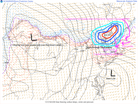
We are now on a wild roller coaster ride when it comes to the weather in the North East. A low pressure system is moving out of the Great Lakes and will be transferring its energy to a secondary low off the NJ coast.

noreaster 12


Graphic overview of storms.

As you can see, there are many factors playing into the forecast. The coastal front, the new low, cold air damming. Cold air damming is when  the heavy cold air stops the advance of Warm air. Where exactly the cold air dam sets up will play a big part in the type of precipitation. The coastal front will play an equally important part on determining precipitation types. As shown, the east winds off the warm water will bring in warmer air. This will turn snow/sleet/freezing rain into all rain. Expect this to move inland Monday-tuesday.

After the coastal front moves inland, Wednesday will already be here as will another storm. This new storm will be MUCH stronger.

noreaster 13


This graphic depicts the setup Monday-Wednesday. The coastal front from tonight will move way inland turning everyone except the ski resorts over to plain rain. The wednesday low will move swiftly through the Gulf of Maine and into the Canadian Maritimes. On the backside of this system the cold air will make a comeback turning everyone back over to snow Wednesday evening-night. Accumulations should be light.

After we get the Monday and Wednesday storms out of the way, there will be yet another low Friday. This is a little too far out to accurately forecast so I will detail that in a later Post coming Wednesday-Thursday.

-Jack

Advisory #2 on new Nor’easter

The next storm the east coast will be facing will be a very bad storm for Sandy ravaged areas. This storm will likely bottom out at 990mb slightly weaker then estimates from this morning and a day ago. These estimates suggested pressures of near 980mb. Regardless of pressures, this will be a very bad storm for all ravaged by Sandy. Winds of 35-50mph will ravage areas hit hard by Sandy. Models are trending east with this storm which means that there will be cool air in place in Maine allowing for some snow possibly accumulating to a few inches in mountainous areas. areas closer to the coast may see up to 1″. Accumulations will be tricky to forecast here due to the fact that the ground is warm and it will be a while for the ground to cool off enough to allow for snow to accumulate. 1-2″ of rain will be common from northern NJ to Cape Cod and possibly Seacoast NH.

-Jack

Watching the models closely…

This is a special post to tell everyone that many of the models seem to like the idea of a powerful nor’easter heading up the coast next week.

Stay Tuned for updates!

-Jack

New Models Show Less Impacts in Maine While Mid-Atlantic Sates Get Hit Hard

New models out this morning show Sandy/Frankenstorm making landfall in Centeral NJ Monday evening. This would deliver quite a surge to theNYC area. Surge heights would be on the order of 6-10′. Irene, for example, delivered a 4-5′ surge and missed flooding the subways by mere inches. With 5 extra feet of water and waves already on the order of 8′ in New York Harbor, subway flooding is a real possibility.

Station 44065 NDBC
Location: 40.369N 73.703W
Date:Sun, 28 Oct 2012 10:50:00 UTC

Winds: NNE (30°) at 21.4 kt gusting to 25.3 kt
Significant Wave Height: 8.5 ft
Dominant Wave Period: 12 sec
Mean Wave Direction: SSE (153°)
Atmospheric Pressure: 29.82 in and falling
Air Temperature: 58.3 F
Dew Point: 53.1 F
Water Temperature: 61.9 F
Bouy data from the entrance of New York Harbor.

For those of us who this means nothing to, there are only a few things that are important, 1) Significant Wave Height. This is simple and self-explanitory. How high the waves are above the average water level (excluding tides. Ex: 12 foot waves with a 2 foot surge would be reported as a Sig. Wave Height of 12 not 14). 2) Dominant Wave Period. This shows how powerful the blast of energy creating the wave is. The higher the number in seconds, the more powerful the wave (Ex: a wind blown chop has a 2 second period while a tsunami wave has a 5-8 minute period). 3) The obvious wind and pressure to show the weather in general.

Station 41002 NDBC
Location: 31.862N 74.835W
Date:Sun, 28 Oct 2012 10:50:00 UTC

Winds: NNW (330°) at 36.9 kt gusting to 46.6 kt
Significant Wave Height: 20.0 ft
Dominant Wave Period: 10 sec
Mean Wave Direction: NE (36°)
Atmospheric Pressure: 28.73 in and rising rapidly
Air Temperature: 75.6 F
Water Temperature: 77.7 F

Bouy data from 225 Miles SE of Cape Hatteras.

As you can see by the green Barometric pressure line, the storm center has already pass by though impacts are still severe.

Impacts will be lessened here in Maine due to the storm’s eastern band falling apart. This means that there is not heavy storm on the right hand side of the system. Dont let your gaurd down though…  The storm could easily at any moment decide to build a formidible eastern side or just as easily decide not to. Stay tuned!

Morning Satellite shot of Frankenstorm. As you can see the eastern half is fairly bleak sparing much of Northern New England

Winds will be in the 30-60ph range peaking Monday. This is for Maine and New Hampshire. 40-65mph for Massachussets. 50-70mph for Rhode Island. 60-80mph for New Jersey where the center of the storm moves in. 70 mph for NYC and Long Island. 50-70mph for much of MD with 45-60mph in far western regions. 35-55mph for Eastern VA with 25-45mph for Western regoins.

Tides will be running 2-4′ above normal due to surge in Maine and 1-3′ above normal due to the full moon. This will cause low-lying areas in Portland to flood. These areas will be along low-lying commercial street and areas adjecent to Back Bay as well as anywhere else that is less than 5-6′ above sea level.

Sandy is currently a Category 1 storm with top winds of 75mph. Below is the full NHC advisory.

…SANDY EXPECTED TO BRING LIFE-THREATENING STORM SURGE FLOODING TO THE MID-ATLANTIC COAST…INCLUDING LONG ISLAND SOUND AND NEW YORK HARBOR… …WINDS EXPECTED TO BE NEAR HURRICANE FORCE AT LANDFALL…


8:00 AM EDT Sun Oct 28
Location: 32.1°N 73.1°W
Moving: NE at 10 mph
Min pressure: 951 mb
Max sustained: 75 mph

This is the data and here is the full write-up. For more info including graphics, go to the nhc home page which can be found at the right of my page.

000
WTNT33 KNHC 281159
TCPAT3

BULLETIN
HURRICANE SANDY INTERMEDIATE ADVISORY NUMBER  24A
NWS NATIONAL HURRICANE CENTER MIAMI FL       AL182012
800 AM EDT SUN OCT 28 2012

…SANDY EXPECTED TO BRING LIFE-THREATENING STORM SURGE FLOODING TO
THE MID-ATLANTIC COAST…INCLUDING LONG ISLAND SOUND AND NEW YORK
HARBOR…
…WINDS EXPECTED TO BE NEAR HURRICANE FORCE AT LANDFALL…

SUMMARY OF 800 AM EDT…1200 UTC…INFORMATION
———————————————-
LOCATION…32.1N 73.1W
ABOUT 260 MI…420 KM SE OF CAPE HATTERAS NORTH CAROLINA
ABOUT 395 MI…635 KM E OF NEW YORK CITY NEW YORK
MAXIMUM SUSTAINED WINDS…75 MPH…120 KM/H
PRESENT MOVEMENT…NE OR 40 DEGREES AT 10 MPH…17 KM/H
MINIMUM CENTRAL PRESSURE…951 MB…28.08 INCHES

WATCHES AND WARNINGS
——————–
CHANGES WITH THIS ADVISORY…

NONE.

SUMMARY OF WATCHES AND WARNINGS IN EFFECT…

A TROPICAL STORM WARNING IS IN EFFECT FOR…
* CAPE FEAR TO DUCK NORTH CAROLINA
* PAMLICO AND ALBEMARLE SOUNDS
* BERMUDA

HIGH WIND WATCHES AND WARNINGS FOR HURRICANE-FORCE WINDS ARE IN
EFFECT FOR PORTIONS OF THE MID-ATLANTIC STATES.  OTHER WATCHES AND
WARNINGS ARE IN EFFECT FOR MUCH OF NEW ENGLAND. SEE STATEMENTS FROM
LOCAL NATIONAL WEATHER SERVICE FORECAST OFFICES.

FOR STORM INFORMATION SPECIFIC TO YOUR AREA IN THE UNITED STATES…
INCLUDING POSSIBLE INLAND WATCHES AND WARNINGS…PLEASE MONITOR
PRODUCTS ISSUED BY YOUR LOCAL NATIONAL WEATHER SERVICE FORECAST
OFFICE. FOR STORM INFORMATION SPECIFIC TO YOUR AREA OUTSIDE THE
UNITED STATES…PLEASE MONITOR PRODUCTS ISSUED BY YOUR NATIONAL
METEOROLOGICAL SERVICE.

DISCUSSION AND 48-HOUR OUTLOOK
——————————
AT 800 AM EDT…1200 UTC…THE CENTER OF HURRICANE SANDY WAS LOCATED
NEAR LATITUDE 32.1 NORTH…LONGITUDE 73.1 WEST. SANDY IS MOVING
TOWARD THE NORTHEAST NEAR 10 MPH…17 KM/H…AND THIS GENERAL
MOTION IS FORECAST TO CONTINUE THROUGH TODAY.  A TURN TOWARD THE
NORTH AND THEN NORTHWEST IS FORECAST ON MONDAY.  ON THE FORECAST
TRACK…THE CENTER OF SANDY WILL MOVE PARALLEL TO THE SOUTHEAST
COAST OF THE UNITED STATES TODAY AND TONIGHT…AND APPROACH THE
COAST OF THE MID-ATLANTIC STATES BY MONDAY NIGHT.

MAXIMUM SUSTAINED WINDS ARE NEAR 75 MPH…120 KM/H…WITH HIGHER
GUSTS.  LITTLE CHANGE IN STRENGTH IS FORECAST DURING THE NEXT
COUPLE OF DAYS…AND SANDY IS EXPECTED TO BRING HURRICANE-FORCE
WINDS TO PORTIONS OF THE MID-ATLANTIC STATES.

HURRICANE-FORCE WINDS EXTEND OUTWARD UP TO 175 MILES…280 KM…FROM
THE CENTER…AND TROPICAL-STORM-FORCE WINDS EXTEND OUTWARD UP TO
520 MILES…835 KM. A SHIP LOCTAED ABOUT 100 MILES SOUTH OF
MOREHEAD CITY NORTH CAROLINA RECENTLY REPORTED SUSTAINED WINDS NEAR
HURRICANE FORCE. ALSO…NOAA BUOY 41036…LOCATED IN ONSLOW BAY
NEAR THE NORTH CAROLINA COAST…RECENTLY REPORTED SUSTAINED WINDS
OF 47 MPH…76 KM/H…AND A WIND GUST OF 59 MPH…94 KM/H.

THE MINIMUM CENTRAL PRESSURE RECENTLY REPORTED BY NOAA AND AIR FORCE
RESERVE HURRICANE HUNTER AIRCRAFT WAS 951 MB…28.08 INCHES.

HAZARDS AFFECTING LAND
———————-
WIND…TROPICAL STORM CONDITIONS ARE SPREADING ACROSS THE COAST OF
NORTH CAROLINA IN THE TROPICAL STORM WARNING AREA…AND THESE
SHOULD CONTINUE THROUGH TODAY.  GALE FORCE WINDS ARE EXPECTED TO
ARRIVE ALONG PORTIONS OF THE MID-ATLANTIC COAST LATER TODAY…AND
REACH LONG ISLAND AND SOUTHERN NEW ENGLAND BY MONDAY MORNING. WINDS
AT OR NEAR HURRICANE FORCE COULD REACH THE MID-ATLANTIC STATES…
INCLUDING LONG ISLAND…BY LATE MONDAY.

STORM SURGE…THE COMBINATION OF AN EXTREMELY DANGEROUS STORM SURGE
AND THE TIDE WILL CAUSE NORMALLY DRY AREAS NEAR THE COAST TO BE
FLOODED BY RISING WATERS. THE WATER COULD REACH THE FOLLOWING
DEPTHS ABOVE GROUND IF THE PEAK SURGE OCCURS AT THE TIME OF HIGH
TIDE…

NC SOUTH OF SURF CITY…1 TO 3 FT
NC NORTH OF SURF CITY INCLUDING PAMLICO/ALBEMARLE SNDS…4 TO 6 FT
SE VA AND DELMARVA INCLUDING LOWER CHESAPEAKE BAY…2 TO 4 FT
UPPER AND MIDDLE CHESAPEAKE BAY…1 TO 2 FT
LONG ISLAND SOUND AND RARITAN BAY INCLUDING NEW YORK HARBOR…6 TO
11 FT
ELSEWHERE FROM OCEAN CITY MD TO THE CT/RI BORDER…4 TO 8 FT
CT/RI BORDER TO THE SOUTH SHORE OF CAPE COD INCLUDING BUZZARDS
BAY…3 TO 5 FT

SURGE-RELATED FLOODING DEPENDS ON THE RELATIVE TIMING OF THE SURGE
AND THE TIDAL CYCLE…AND CAN VARY GREATLY OVER SHORT DISTANCES.
GIVEN THE LARGE WIND FIELD ASSOCIATED WITH SANDY…ELEVATED WATER
LEVELS COULD SPAN MULTIPLE TIDE CYCLES RESULTING IN REPEATED AND
EXTENDED PERIODS OF COASTAL AND BAYSIDE FLOODING.  IN ADDITION…
ELEVATED WATERS COULD OCCUR FAR REMOVED FROM THE CENTER OF SANDY.
FURTHERMORE…THESE CONDITIONS WILL OCCUR REGARDLESS OF WHETHER
SANDY IS A TROPICAL OR POST-TROPICAL CYCLONE.  FOR INFORMATION
SPECIFIC TO YOUR AREA…PLEASE SEE PRODUCTS ISSUED BY YOUR LOCAL
NATIONAL WEATHER SERVICE OFFICE.

RAINFALL…RAINFALL TOTALS OF 3 TO 6 INCHES ARE EXPECTED OVER FAR
NORTHEASTERN NORTH CAROLINA WITH ISOLATED MAXIMUM TOTALS OF 8 INCHES
POSSIBLE.  RAINFALL AMOUNTS OF 4 TO 8 INCHES ARE EXPECTED OVER
PORTIONS OF THE MID-ATLANTIC STATES…INCLUDING THE DELMARVA
PENINSULA…WITH ISOLATED MAXIMUM AMOUNTS OF 12 INCHES POSSIBLE.
RAINFALL AMOUNTS OF 1 TO 3 INCHES WITH ISOLATED MAXIMUM AMOUNTS OF
5 INCHES ARE POSSIBLE FROM THE SOUTHERN TIER OF NEW YORK STATE
NORTHEASTWARD THROUGH NEW ENGLAND.

SURF…DANGEROUS SURF CONDITIONS WILL CONTINUE FROM FLORIDA THROUGH
THE MID-ATLANTIC STATES FOR THE NEXT COUPLE OF DAYS AND SPREAD INTO
THE NORTHEASTERN STATES LATER TODAY.

NEXT ADVISORY
————-
NEXT COMPLETE ADVISORY…1100 AM EDT.

$$
FORECASTER STEWART


Finish preparations for an extended period of time without electricity.

-Jack

New day, New Forecasts

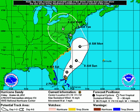
Today, we are looking at only slight adjustments to the forecast. I now think it will make a direct landfall on NYC. There are a couple reasons that I differ from the NHC track taking it into Southern NJ.


NHC track with landfall in southern NJ.

1) Most of the models have my back. All but the GFDL, and the operational Euro make landfall in NYC.

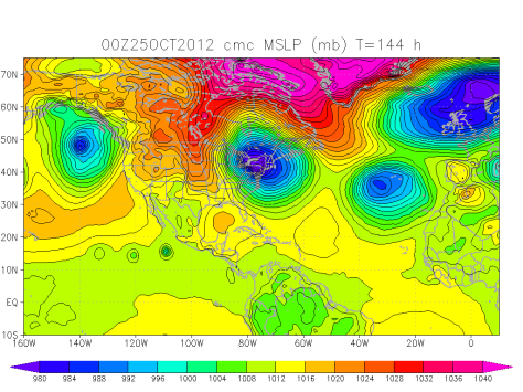
The CMC, just one of the many many models taking Frankenstorm into NYC.

2) Upper air steering. The steering setup would favor a NYC track due to the position and intensity of the trough. The position of the trough and the ridge from the Canadian Maratimes suggests a landfall from North NJ to Mid-Long Island.

This mornings satellite image showing an active Atlantic basin.

Sandy is clearly seen as the storm off the SE coast. There is a normal extratropical mid latatude low SE of Newfoundland. The area in question is that blob in between the two systems. Will nthis blob continue up the coast with Sandy? Or will it join the extratropical low? This is the big question in my mind because if that band makes it up the coast New England could see major impacts. If not, then it would be up to Sandy and her megastorm to create an east side to her. She has planty of time to do that as she moves up the coast first intensifying as a warm-core system over the Gulf Stream then becoming cold-core over the waters south of NYC and feeding of the trough energy. Either way there would be major impacts.

I think 3-5″ of rain would be likely in New England with amouts possibly reaching 12-15″ over parts of NJ and Southern NY.

Winds will likely peak around 60mph along coastal sections of ME with higher gusts possibly reaching hurricane force. This along with our tropical downpours will be cause for insane power outages. Prepare for anywhere from 2-14 days depending on your priority level (hospitals, cities are high priority, island communities, communities high in the mountains and low priority. Anywhere in between like suburbs or the mid sized town would be mid priority). Winds in NYC will likely be hurricane force with NJ also seeing hurricane force winds. DE, PA, New England, MD, and VA, NC will see tropical storm force winds.

Also, changes this morning, timing. Effects will begin Monday and linger possibly into the end of the workweek. This is because of the effects that I think the mountainous regions of NY will have on slowing the Frankenstorm down. Earlier, it was thought to move over less mountainous terrain and be moved along very quickly by the trough.

-Jack


2 PM Update for “Frankenstorm”

The Sandy/Nor’ easter hybrid superstorm set to impact the Eastern Seaboard this weekend into early next week has officially been dubbed “Frankenstorm”. I would assume it as a halloween joke but this storm is not joking around. Power outages could top 10 million customers if the underground power plants for NYC are flooded. Even though this sounds far fetched, it is really not. The NHC (National Hurricane Center) has Sandy Moving onshore in Delaware.


The 2PM track from the hurricane center has Sandy moving onshore in DE as a hurricane.

This would push a 7-11 foot storm tide into NYC. The city has 5 foot flood walls that would easily be overtopped and flooding lower Manhattan and the financial district. The water would rush into the subway system shorting out the electric 3rd rails. Also this surge would rush through the intricate tunnel system making for a huge mess. The power plants are located in these tunnel systems and would be shut down on purpose in anticipation for the storm or, they would get knocked out of service by the surge flooding.

This is supported by few models however and is only there for the European model (ECMWF) which predicts a DC landfall. This is the number one performer among models. There are several less reliable models that like this scenario as well. The second best performer has Sandy making a direct hit on NYC Sunday evening.

The black and purple swath is the Frankenstorm Nor’easter hitting NYC as shown by the American GFS model.

This is a very reasonable scenario for a few reasons. 1) There is a low pressure system located in the Central Atlantic Ocean now and this will act to pull Sandy towards the sea. 2) There is a trough of low pressure moving in from the west as well.


Radar Imagery from 2:50 PM today of the colds front and trough moving in from the west.

This trough will act to pull in Sandy from the SE hitting the NYC area. The max surge would be 15 feet. The trough will also give Sandy a boost of energy which will allow the storm to “bomb out” or undergo cyclogenisis (the rapid deepening or strengthening  of a low). The trough will then pull Sandy to the north through western MA and VT.

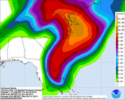
The cold front and trough will act to create the heaviest October rains ever recorded by taking moisture saturated air and slamming it into cold Canadian air which will mass condense it. The result? Up to 15″of rain for some areas.


The HPC (Hydrometerological Prediction Center) forecast for rainfall. This is in connection with the NHC track so these 15″+ amounts might stretch farther north into NJ and NY. Also, this is only to Wednesday, it will be raining all the way through Thursday for parts of Northern New England.

Speaking of cold air… there will be a snowy side to this system. The storm is very lopsided due to shear, and that will cause the storm to spin energy way to the NW of the center where the cold pocket aloft is. This cold pocket will help to create snow for Pennsylvania and any mountains north of NYC.

As you can see, there is no hurricane like anything in this inferred satellite image.

Instead is a mass of clouds that stretch all the way from the Caribbean Sea to the Del-Marva Peninsula. The east side has the most activity so even if the storm hits NYC, New England will feel harsh impacts. Although the east side is larger, the storm will grow substantially by the time of landfall and will be able to push activity well to the NW of the center.

-Jack


Large Storm to Impact Eastern Seaboard

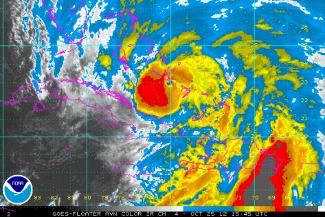
There is a complex weather situation at play now as Hurricane Sandy moves up the Eastern Seaboard. The latest advisory puts Sandy as a 105mph Hurricane with a lowest pressure is 964mb. Sandy has just moved off the northern coast of Cuba.

Sattellite imagery of Sandy moving off of Cuba.

Now Sandy will continue moving north and then the second factor comes into play. This second factor is a trough of low pressure moving in from the west. This trough will pull in sandy towards the US. Sandy will then “bomb out” off of the NJ coast. Pressures will fall like a rock bottoming out near 949 mb. This is the general consensus of the numerical models. (These are super computers located around the world that take in weather data from around the world. Then this data is fed through a prisim of equations that produce graphs that we weather geeks/ meteorologists then interpert and make forecasts from).

Sandy will then be a Nor’Easter on steroids. This super-noreaster will then move into the coast south or on top of New York City. Surge flooding will be of great concern. There is a 5 foot seawall protecting the financial district from New York Harbor. This storm will be over 2500 miles wide and close to 3500 miles long. This huge storm will generate a 9-12 foot surge on top of the astronomical high tide caused by the full moon on Monday. This would most likely cause flooding in lower Manhattan.

There will be a snowy side to this storm as well. This will be the tropical moisture from Sandy moving up the coast meeting the arctic airmass behind the trough. Pennsylvania and Western New York State as well as the mountains from the Allegheny Mountains in Pennsylvania to the mountains near Mt. Katahdin, Maine could see snow.

CMC Numerical model plot for Mega Noreaster Sandy.

Snow amounts will be on the order of 4-8″ for lowland Pennsylvania to over 28-36″ on the higher peaks.

Rainfall will also be greatly enhanced by the warm moist air hitting the cold air from Canada causing the heaviest October rains in history. Rainfall amounts could reach over 20″. 12″ is expected over most regions.

Winds will be on the order of potentially 80mph in NYC where the worst of the storm will be. 55-70mph will be widespread with higher gusts. The coast of ME, MA, RI, CT, NY, NJ, and DE will see highest winds peaking around 50-65mph in many places. Exposed areas could get even higher gusts.

Timing will be Saturday-Monday for areas south of VA beach area, Sunday-Tuesday for CT to VA beach area, and Monday-Wednesday for New England.

Cool start to the week warmer temps by thursday

A cold front swept through last night leaving up to 5″ in the heavy snow bands. This will allow for high pressure and colder temperatures to dominate Monday and Tuesday. Wednesday the high will shift offshore bringing a warm flow with rebounding temps. 50s Wednesday and 60 thursday.

Stay tuned!

-JAck