
Hello everyone!
I hope all you worshipers of warmth enjoyed your brief break, because winter’s comeback is beginning. Rain and snow will arrive tomorrow evening becoming mostly snow during the overnight hours. Snow will last through the mid morning hours before tapering off to flurries/drizzle by Wednesday afternoon. After that, an active pattern looks to kick into gear with a possibly significant precipitation event by the end of the week.

The setup for this event involves almost everything you can see on the map here. Cold air is moving SE into the area as a backdoor cold front moves through tonight. Our storm is located all the way back in Kansas and will weaken as it moves NE. The moisture pipeline will be in business from the Gulf of Mexico but it will be weakening along with the storm. The bottom line: with all the elements weakening as they approach us and the pattern across the Northern Hemisphere generally being flat/zonal, this won’t be an event that features heavy precip. Let’s look at some of the dynamics associated with the system to test that hypothesis.

The pattern aloft can give many clues as to how storms will behave at the surface and this time is no different. For big storms, we want our upper level energy to be strong, negatively tilted, and consolidated. This situation will feature the exact opposite of that as our energy is weak, strung out, and positively tilted. Even though a coastal low will develop, it will move east then south-east rather than north-east up the coast. You can thank the positive tilt for that. The two disturbances are separate and the lack of strength can be attributed to this.

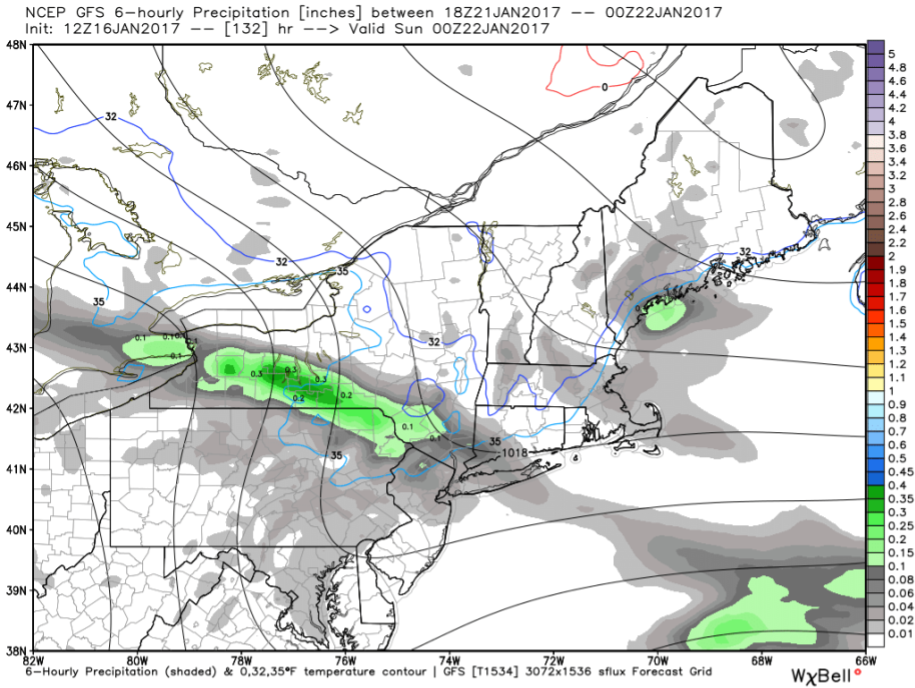
Sure enough, our hypothesis of weak lift/precip holds up in the upward motion department as the 12Z NAM shows. Notice how we enjoy the yellows/oranges rather than the reds/pinks that usually show up on maps like this during big storms. As a result of the weakening surface storm, the disorganized upper level dynamics, and the weak lift, precip will be light to moderate at best and heavy bands are not expected.
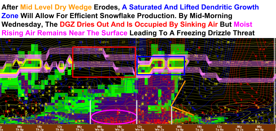
Here’s the NAM’s take on the event shown through a vertical cross-section of the atmosphere above Portland through time. While the NAM certainly has its flaws, it gives a good look at the various dynamics involved through the event. Notice how the moisture near the surface remains even well after the snow may stop. Given the colder air moving S behind the departing low and the presence of this moisture, look for freezing drizzle to be an issue through the day on Wednesday. This will result in slick roads even after the snow moves out.

Precip will arrive tomorrow evening in the form of snow inland and a rain/snow mix along the immediate coast. Everyone except the extreme SE midcoast (Rockland) and coastal York County will quickly go over to snow which will be the dominant precip type throughout the event. As coastal low pressure develops off Long Island, expect precip to become focused in the southern half of the area by Wednesday morning before tapering off to flurries and freezing drizzle by Wednesday afternoon. A weak inverted trough will act to keep the moisture around for that freezing drizzle even well after the snow departs.

Here’s what I think everyone will end up with when all is said and done on Wednesday afternoon. The coast sees the least due to mixing and totals drop off to the NE as less precip will fall there. The Jackpot will be in NH and far W ME where 6-8″ are possible in the foothills and mountains. This will be a great refresh for the ski areas especially those in the whites and places in Maine like Sunday River, Shawnee Peak, and Mt Abram. Farther NE, Sugarloaf will definitely get some flakes but won’t have the lift to squeeze out more than 2 or 3″. I’ll see if I have time to update this tomorrow before the flakes fly.

More flakes will be in the air on Thursday as a cold front/weak storm drifts by to our north. The mountains and far north will see the most out of this one with a whopping 1″ possible. Some upslope areas might see 2″ but that’s about it. Farther south, flurries can be expected across the foothills and coastal plain while the shorelines and southern NH may not see anything at all. The timeframe for this is during the day on Thursday.
Our pattern of many weak little events will continue Saturday with the arrival of cooler air accompanied by rain and snow showers. At the moment, accumulations look to be less than an inch away from the coast but the cold air is important because it will set the stage for the next event which will arrive sometime this coming weekend or early next week. Whatever that event may be, it will likely bust up our ‘halftime’ pattern, ushering in colder and stormier weather to finish January and begin February.
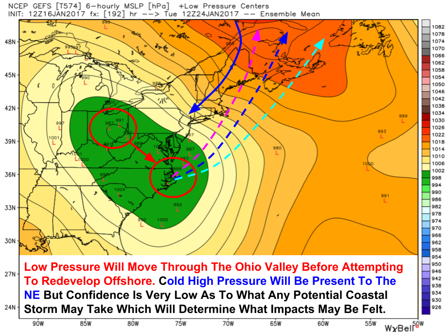
Here is a quick look at the potential storm system early next week (about 7-8 days from now). As with any potential system that far out, the details are up in the air but ensemble guidance is supported by the large-scale pattern in suggesting some sort of system could be brewing around then. I’ll have more as we get closer if it continues to look like an impactful storm is a possibility.

Now I’ll take a minute to look forward at the pattern for the next couple weeks. Winter is coming back and the change is beginning at the very top of the atmosphere right now. Temperatures in the stratosphere over the North Atlantic have warmed dozens of degrees Celsius in just a few days and this will be a killer blow to the stratospheric polar vortex (the real one, not the fake one the TV stations make up for ratings/clicks/likes/shares etc). By the time we get to the middle of next week, the vortex (light blue) will be considerably weaker than it is now as multiple Sudden Stratospheric Warming events occur (red circles).
The weaker polar vortex will allow cold air to spill southward resulting in a return to winter for Maine and New Hampshire. These changes to the pattern are beginning now and will likely begin to influence our pattern by the time that storm early next week arrives in one form or another. In short, the comeback is coming.
More this week if I have time between school work, track, and sleep.
-Jack
