Tag Archives: snow

Christmas forecast and a look at the week ahead…

Christmas is finally almost here (3 days away!) and many of us are wondering if it will be a white christmas.

Today and Tomorrow will be cold and windy but no major problems across the northeast. The lake effect machine will be cranking today across typical areas. A few light flurries are possible across the north east today but any will be very light and will not cause any disruptions.

As we head into christmas eve, there could be some light rain/rain showers in the ohio valley but nothing major. When Santa arrives Monday night, he can expect light snow across southern New England.

There looks to be the potential for snow on Christmas day. However, activity will be light and will be focused across southern New England.

storm 3c

Snowfall map.

The disturbance creating this christmas snow will be weak by any standards and will skirt south of ME/NH. MA/RI/CT will see the most snow. Accumulations should be light and travel impacts will be low to none.

As we head into the middle of next week, there looks to be a stronger noreaster Wednesday night inot Thursday. Totals should be much higer with that storm yet it is too early to tell specific amounts.

storm 3d

Tracks of next week storms.

Cold air shoulf remain in control Thursday so it should be a predominantly snow event.


Stay tuned for more about the upcoming storms!

-Jack

Large Storm to Impact Eastern Seaboard

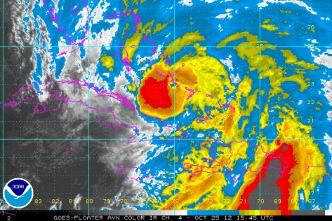
There is a complex weather situation at play now as Hurricane Sandy moves up the Eastern Seaboard. The latest advisory puts Sandy as a 105mph Hurricane with a lowest pressure is 964mb. Sandy has just moved off the northern coast of Cuba.

Sattellite imagery of Sandy moving off of Cuba.

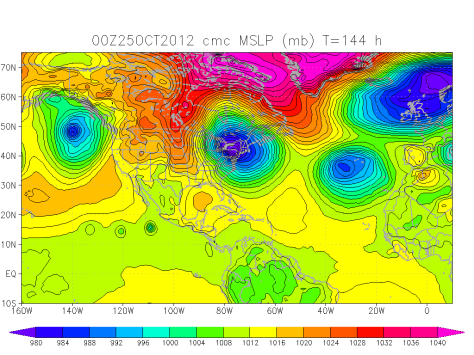
Now Sandy will continue moving north and then the second factor comes into play. This second factor is a trough of low pressure moving in from the west. This trough will pull in sandy towards the US. Sandy will then “bomb out” off of the NJ coast. Pressures will fall like a rock bottoming out near 949 mb. This is the general consensus of the numerical models. (These are super computers located around the world that take in weather data from around the world. Then this data is fed through a prisim of equations that produce graphs that we weather geeks/ meteorologists then interpert and make forecasts from).

Sandy will then be a Nor’Easter on steroids. This super-noreaster will then move into the coast south or on top of New York City. Surge flooding will be of great concern. There is a 5 foot seawall protecting the financial district from New York Harbor. This storm will be over 2500 miles wide and close to 3500 miles long. This huge storm will generate a 9-12 foot surge on top of the astronomical high tide caused by the full moon on Monday. This would most likely cause flooding in lower Manhattan.

There will be a snowy side to this storm as well. This will be the tropical moisture from Sandy moving up the coast meeting the arctic airmass behind the trough. Pennsylvania and Western New York State as well as the mountains from the Allegheny Mountains in Pennsylvania to the mountains near Mt. Katahdin, Maine could see snow.

CMC Numerical model plot for Mega Noreaster Sandy.

Snow amounts will be on the order of 4-8″ for lowland Pennsylvania to over 28-36″ on the higher peaks.

Rainfall will also be greatly enhanced by the warm moist air hitting the cold air from Canada causing the heaviest October rains in history. Rainfall amounts could reach over 20″. 12″ is expected over most regions.

Winds will be on the order of potentially 80mph in NYC where the worst of the storm will be. 55-70mph will be widespread with higher gusts. The coast of ME, MA, RI, CT, NY, NJ, and DE will see highest winds peaking around 50-65mph in many places. Exposed areas could get even higher gusts.

Timing will be Saturday-Monday for areas south of VA beach area, Sunday-Tuesday for CT to VA beach area, and Monday-Wednesday for New England.

Mid-Storm update

Heavy snows spreading across the area now in bands bringing good accumulations piling up very efficiently. On that note I will need to update the snow totals for SW ME to 10-16″ due to a more northerly trend in the latest model run. Also need to say that winds have been picking up and will be peaking shortly. Winds will average 20 mph gusts around 30 out of the NE. Peak winds will be found at the coast.

Stay tuned!

-JAck

Snow storm Thursday

A powerful winter storm is preparing to slam the region with heavy snow as well as some wind though the snow will really grab headlines. 8-12″ are expected in Cumberland and York Counties in ME and most of SW NH as well. 3-6″ in northern NH and in ME North to Augusta. 1-3″ in northern ME.

A powerful low will extend a warm front ahead of its move SE under a powerful high. This will bring a good steady snow and efficient accumulation. see other post for more in-depth analysis.

Stay tuned!

-JAck

Thursday snow

Wednesday – Wednesday night – Thursday – Thursday night will show us some winter here where last Fridays storm left us out. The farther south in ME you go the more snow you will get. 1′ is expected south of Auburn with 6″ towards Augusta and 1-3″ anywhere north of that.

A warm front will move north starting precip Wednesday. This front will stall and still produce precip while a upper trough (still binging precip) that will stall as well (still bringing precip) will trigger a secondary low that will partially stall (still bringing precip though this precip will be heavy) and rapidly develop bringing heavy precip. Next, adding to the cauldron of meteorological developments piling up almost as fast as the snow; another upper trough ( still bringing heavy snow) will nudge the existing upper trough, the warm front, and the coastal low into motion. A third upper level trough and a cold front will continue the snow into early Friday morning.

Stay tuned!

-JAck

Thursday snow storm

Thursday will likely be our last chance at a very significant snowfall. A low will be moving out of the Great Lakes and will be nudged south by a fairly strong high in southern Quebec. This is a very cold high spilling cold air over the region so precipitation type will not be an issue with the exception of maybe Kittery where the warm air will be located. Confidence is still low so stay tuned for more updates.

-JAck

Quick update

Snow has arrived and will remain entrenched through the night. Cyclogenisis has begun and 2-4″ per hour snowfall rates will be common inland ( 15 miles inland from the coast.) and 3″ per hour rates at the coast though inefficient accumulation will lead to lesser totals. Thunder will be likely at the peak intensification time ( 10pm-2am)

Snow amounts stay the same.

-JAck


Update #3

4:15pm EST Friday 2-24-12

New radar updates filtering in now and the situation is clear. Definite spin with the original low and secondary low forming as well. The low has stalled and so precip will hold off until after dark. Second low will intensify as it moves NE and bring more stable accumulations with dropping temps. Snow will end near dawn Saturday in most areas excluding the mountains where upslope snow showers will continue to crank Saturday

Snow amounts
Coast south of Portland- Coating to 1″
Coast north of Portland – Bath excluding Yarmouth, Freeport and Falmouth 1-3″
5 Miles inland to 20 Miles inland including interior Casco Bay- 3-6″
20 miles inland to mountain zones 4-8″
Mountains- 10-14″

Strong coastal low developing rapidly with cyclogenisis occurring near 40N 70W as the low moves NE.

Updates will continue to flow in as the weather continues to progress.

Jack

Update #2

7:45 pm EST Thursday 2-23-12:
New forecasts coming in now and still trending cooler. This means that the secondary low will develop more quickly and reach a greater intensity before being driven off by approaching high pressure that will be building in for Saturday.

Low will approach the area tonight and snow will start at around 5:30am. Little accumulation before dawn but this thin layer will set the stage for more efficient accumulations with heavy snows later. Heavy snow will come with the 2nd low forming roughly 50 miles NE of Boston. This new low will start out fairly strong and will continue to deepen though cyclogenisis is not expected at this point. The new low will start to pull in sufficient cold air starting around 11:00. Warm air advection (which is warm air interacting with cold air usually overtaking it and produces precipitation) will be halted or significantly slowed by this point due to cool air being wrapped in by this point by the secondary low.

East winds brought on by the secondary low passing south of us will draw in warmer air along the coast and we will see a change to sleet possibly mixing with rain.

Snow amounts: Southern York County: 1-3″
Coast north of Portland to 20 miles inland: 3-5″
Inland and foothills: 4-6″
Mountains: 6-10″

Stay tuned!

-Jack

Update #1

3:45 pm EST Thursday 2/23/12: Snow will overspread the region Friday Morning and continue throughout the day peaking at around noon. Temps will hover near freezing or a little bit above throughout the day. Temps will sharply rise in the 500 hour when a warm front comes through. This will cause a change to rain up until maybe 5 miles from the immediate coast. This changeover will persist for an hour or 2 and then cooling takes place after dark returning snow for all. Snow will taper off and end at around 2-3am north to south. Clear skies return with blustery conditions saturday.