Tag Archives: spring

Another Inland Cutter This Week

Hello everyone!

The forecast for Wednesday into Thursday remains on track this evening. As it is drawing nearer, I’ll elaborate a little on the expected impacts which include snow, sleet, freezing rain/ice, heavy rain, and wind. I’ll do a quick rundown of each threat. All in all, this will be a fairly typical inland runner and nothing out of the ordinary is expected for Maine. One wave of precip will arrive during the day Wednesday into Wednesday night while the second will arrive Thursday morning and continue through Thursday afternoon. A third wave is likely following that which will last into early Friday morning.
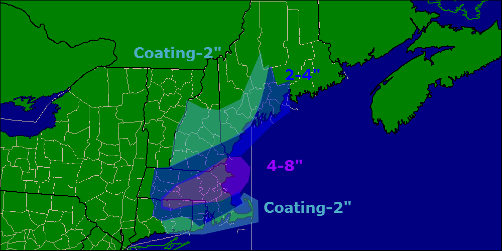
Wave One: Snow

12Z GFS Showing The Setup For Snow Wednesday Morning. Image Credit: Accuweather

Ahead of the storm, we have fairly cold air (step outside if you don’t believe me). As per usual, cold air leaves when it pleases and as warm air begins to move north, the first phase of the fight will feature snow Wednesday morning. A general 1-3″ is expected before warm air aloft moves in to turn things over to sleet and freezing rain. A bit more is expected in the mountains where I could see 2-4″. I also wouldn’t be surprised if coastal areas only saw a coating. This will fall overnight tomorrow into the early morning hours Wednesday. As dawn breaks Wednesday, warm air aloft will be gradually changing things over to sleet and freezing rain from south to north.

Wave One: Mix

12Z GFS Showing The Cold Air Damming Setup At The Surface Wednesday Night. Image Credit: Accuweather

While warm air will stream in unopposed aloft, the cold will put up a good fight at the surface. High pressure will be slowly sliding east across the Canadian Maritimes and I expect low level cold to hang on for a good long time. The map at left shows winds at the surface Wednesday evening. Notice NE winds still locking in cold air at the surface Wednesday night. The development of weak low pressure offshore will aid in this process. This wind will continue to cause problems even into the beginning of wave two which arrives Thursday morning just as this is beginning to erode. Several tenths of an inch of ice are possible and could lead to power outages especially if it doesn’t get a change to melt before the high winds associated with the cold front arrives.
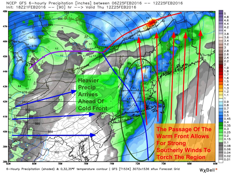
Wave Two: Rain

12Z GFS Showing Heavy Rain Moving In Thursday. Image Credit: Weatherbell

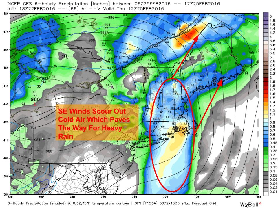
Eventually, the cold air will be swept out of the way as SE winds pick up. A cold front will be approaching and ahead of it will be a line of heavy showers with some embedded thunder possible. A general inch to two inches of rain is likely which could lead to minor drainage/urban flooding. Despite that, no major issues are expected as we hardly have any snowpack to melt away.

Wave Two: Wind

12Z GFS Showing High Winds Once Again Lurking Above The Surface. Image Credit: Accuweather

As is usually the case with these storms, a band of strong winds will cross the area around the time of the heavy rain. The heavy rain will help mix some of those winds to the surface which could lead to scattered power outages. Notice the lack of bright pinks and purples in this map where we had them covering the entire region last week. Winds this week will be slightly weaker with 40-50 mph gusts most likely (last week we had 50-60 mph winds).

Wave Three: Light Mountain Rain/Snow

12Z GFS Showing Light Rain And Snow Moving Back In Friday Morning As Cold Air Pours Back In. Image Credit: Weatherbell

As cold air pours back into the area Thursday evening, an upper disturbance will pass overhead which will cause another batch of precip to move through. This will be most widespread in the mountains but everyone has a shot at a quick coating-2″ of snow as westerly winds bring the cold back in. This should move in late in the evening Thursday and should be out of here by dawn Friday.

More updates in the coming days.

-Jack

Rain Expected This Week As Another Strong Storm Lifts West

Hello everyone!

Yet another storm has decided to cut west this week as our pattern continues to disappoint for skiers and other winter enthusiasts. This storm will be a lot like our last storm and will, as with most inland runners, feature front end frozen precip, heavy rain, and high winds. Precip moves in Wednesday afternoon and moves out Thursday evening.

12Z GFS Showing The Setup With The First Wave Wednesday Evening. Image Credit: Weatherbell

The storm will, as these storms usually do, take place in two stages. The first stage will be Wednesday afternoon into Wednesday evening with light snow changing to ice and rain. During this time, the warm front will be lifting north and cold high pressure will still rule with some weak Cold Air Damming in the mix as well. Accumulations will be on the light side, probably remaining under 3″ of snow though exact amounts are still yet to be determined.

12Z GFS Showing The Setup For The Second Phase Of The Event Thursday Afternoon/Evening
12Z GFS Showing The Setup For The Second Wave Thursday Afternoon/Evening. Image Credit: Weatherbell

A lull will occur Thursday morning as the warm front passes north. Winds will become strong out of the S/SE which will blast out any of the last cold pockets. Heavy rain associated with the cold front will approach and move into the area Thursday afternoon/evening and will bring with it the standard high wind/heavy rain threats with localized flooding and power outages possible. Exact winds are still to be determined but will likely be just a click below those of our last event which would indicate gusts to or around 50 mph along the coast with lighter winds inland.

Colder air moves in for next weekend along with another shot of snow currently centered around Saturday.

-Jack

Next Week Looks Stormy, Details Remain Uncertain

Hello everyone!

Our storm this upcoming week is still on track but just because we’re getting closer to the event doesn’t mean we’re all that much closer to deciphering what will happen. The trend in guidance over the past 24 hours has been towards a warmer solution with brief snow quickly going over to rain. While this remains very much a viable solution, I’m not ready to bite just yet. I want to wait for a few more rounds of guidance with better sampling of the disturbances that will eventually form the storm before I pull the trigger on a rainy solution. Due to that, my thoughts haven’t changed much. A cold front will move through tomorrow night and colder air will follow for Monday. Low pressure will then move NE from the Gulf of Mexico. Its exact track will determine what falls from the sky. We should have a better idea Monday afternoon as the disturbances that will form the storm begin to join together over Texas.

12Z GEFS Showing Uncertainty In The Forecast For Next Week. Image Credit; Weatherbell

Here are the GFS ensembles for the storm. While there is still a large spread in ideas as to where the storm will track, guidance is converging on an inland track. Notice the lack of a large high to the NE to feed cold air into the region. Our cold high from Monday has already been swept off to the Azores which leaves warm air free to flood northward. While I’m still not completely convinced, this is the solution I’m leaning towards based on the pattern and what I’m seeing in terms of guidance.

Following this storm, colder air moves in for the weekend and we have another shot at snow around that time as well.

-Jack

A Messy Saturday As We Once Again Track The Rain/Snow Line

Hello everyone!

Quick update this evening to bring you up to date on the latest info regarding our next storm system arriving tonight and hanging out through tomorrow afternoon. For the most part it will be a fast-mover with precip ending in the early afternoon but while it’s here, the mountains could pick up some decent snowfall for this time of year.

Click around on the map to view precip types and approximate changeover times for your local area.

Rain moves into the region in the wee hours of the morning tomorrow and will start as all rain but will quickly change to snow in the higher elevations before dawn. Snow levels will drop as the low intensifies in the Gulf Of Maine and pulls in cold air on the NW side. Expect everyone to see flakes in NH and ME by early afternoon with western MA likely seeing a few flurries as well. It will be a race against time as the cold air rushes SE to try to get to the coast before the precip departs and just who wins is still a bit up in the air.

In every storm there is bust potential and while forecast confidence is pretty high, the exact extent of the rain/snow line as the precip leaves is still an unknown. As of now, it looks like the Maine coast with the exception of a few of the peninsulas will see at least a few flakes with most of coastal MA and all of RI missing out on the white but don’t be surprised if the snow comes in a little earlier than expected and totals are a little higher. Models have tended to place lows to the NW of their actual positions so if this low ends up a little farther SE and a little colder, I wouldn’t be too surprised. With this in mind, while coastal areas don’t look to see any accumulations, a quick coating is possible should a colder solution occur.

A rumble of thunder is also likely across MA RI and CT and some small hail is possible in some of the stronger cells.

Winds will kick up tomorrow as the storm moves out and gusts over 35 mph are widespread so watch for some isolated power outages especially in areas where snow has accumulated on branches and power lines.

I’ll have another update in the morning as the rain/snow line sets up.

-Jack

Another Toasty Day Before Winter Returns This Weekend

Hello everyone!

Today will feature toasty temps (we’re starting off in the 30’s for most areas this morning) which will climb into the upper 30’s to low 40’s in the mountains and all the way to 50 degrees at the coast. NW winds will help to br driving the warm temps as downsloping occurs to the east/south of the mountains. A mix of sun and clouds is expected with some dense fog this morning over southern areas. A Dense Fog Advisory is out for York County due to that threat this morning.

Cooler temps arrive once another cold front moves through tonight and some accumulating snow looks likely for the weekend.

-Jack

Downsloping Brings Toasty Temps Today

Hello everyone!

Temps will soar especially along the coast today as winds turn to the NW and begin to downslope. Downsloping in turn causes sunny skies and warm temps so temps will be rising into the high 30’s/low 40’s region wide, including the mountains under increasingly sunny skies. A secondary cold front moves through this evening so this warm spell looks to be short-lived but more warm temps look to come back next week as the pattern begins to change.

-Jack


Snow Moves Out This Morning, Mountain Clouds/Coastal Sun Remains

Hello everyone!

Light snow is moving out this morning as our storm pulls away and we will be left with plentiful clouds for most of the morning hours. Expect snow showers to continue in the mountains through the afternoon where several inches of upslope snow can be expected in the favored areas. Temps in the mountains will be in the upper 20’s. Along the coast, morning clouds will give way to afternoon sun as temps rise into the mid-upper 30’s. Happy spring!

More snow/mixed precipitation should arrive late in the day tomorrow.

-Jack

Snow Moving In This Evening And Out Early Tomorrow Morning

Hello everyone!

Quick update this evening on our light snow event that is beginning across the region currently and will continue through early tomorrow morning.  Light snow is beginning across southern and western areas right now and will continue to spread east this evening. Since the atmosphere is quite dry at the moment, expect some of the radar returns shown below to not be making it all the way to the ground.

radar 3-1

Expect snow to continue through the night tonight before ending early tomorrow morning. Clearing skies can be expected tomorrow along with NW winds and cooler temps. Details on tomorrow’s forecast will come in tomorrow morning’s forecast update.

snow map 3-1


Just a few minor changes to the snow map this evening, highest snow totals look to be south and east with this one yet again. Another storm heads our way midweek with a warmup too.

-Jack

More Clouds This Morning, Light Snow Begins This Afternoon

Hello everyone!

Happy meteorological spring!!* Today will feature increasing clouds in the morning followed by clouds and increasing snow in the afternoon/evening hours. Expect all areas to see clouds by around 9 this morning while snow should wait until after 3 this afternoon.

Temps this morning are anywhere from the 10s below zero to single digits above zero warmest where light breezes still blow. Check out yesterday’s post for an explanation on why that is. Temps will rebound quite well today into the lower 20’s north and higher 20’s south.

precip incoming
NAM Model Showing Precip Moving Into The Area At 5 This Evening

Total snow accumulation thoughts have not changed much since last night and it still looks like the Boston area will pick up the most snow. Last night’s snow accumulation map still represents what I think will pan out in terms of total snowfall.

snow map 2-28

Another batch of precip arrives Wednesday, more details later.

-Jack

*Rules and restrictions apply, see Florida for details 🙂


Dry and warm today

Hello everyone!

Today will feature increasing clouds as a front approaches. Any precip will hold off until after dark. There is currently a band of clouds over Maine which is evident on the Infrared Satellite image which will move out over the ocean this morning leaving sunny skies.

It will be chilly to start this morning with current temps running in the 20’s. Don’t worry though because we will more than double them under mostly sunny skies by this afternoon.

IR map 4-10

Note the clouds back to our west. These clouds are associated with a cold front which will bring some rain tonight and tomorrow.

Thursday morning forecast map 4-10

Here is a look at today’s weather. Big temp difference at the immediate coast vs inland. An onshore wind will keep temps down at the coast.

The weekend looks nice but watch for increasing clouds Sunday ahead of a slow moving, moisture laden cold front for early next week. Heavy rainfall is expected.

-Jack

-Jack