
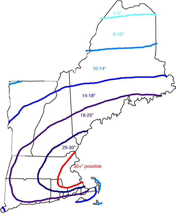
Not much changing now so just the snowfall map. Note: Southern Coastal ME is under a blizzard warning with a winter storm warning elsewhere inland.
-Jack
Tag Archives: Weather
The cold air is arriving…
After a January thaw of sorts, the cold air will return; with vengeance. A cold front will sweep across the area today lowering temps to seasonable levels. Wednesday there is a possibility for some light snow in the south but nothing much. Thursday, an arctic cold front sweeps south bringing below average temps. A warm front moves north Saturday followed by a strong cold front sunday.
as for any snow chances, there could be snow squalls associated with any of the cold fronts most likely not todays. The PNA will move + which is bringing in cool air however models are split down the middle on the AO/NAO but it does not look like any major snow events are in the forecast.
-Jack
New day, New Forecasts
Today, we are looking at only slight adjustments to the forecast. I now think it will make a direct landfall on NYC. There are a couple reasons that I differ from the NHC track taking it into Southern NJ.
NHC track with landfall in southern NJ.
1) Most of the models have my back. All but the GFDL, and the operational Euro make landfall in NYC.

The CMC, just one of the many many models taking Frankenstorm into NYC.
2) Upper air steering. The steering setup would favor a NYC track due to the position and intensity of the trough. The position of the trough and the ridge from the Canadian Maratimes suggests a landfall from North NJ to Mid-Long Island.

This mornings satellite image showing an active Atlantic basin.
Sandy is clearly seen as the storm off the SE coast. There is a normal extratropical mid latatude low SE of Newfoundland. The area in question is that blob in between the two systems. Will nthis blob continue up the coast with Sandy? Or will it join the extratropical low? This is the big question in my mind because if that band makes it up the coast New England could see major impacts. If not, then it would be up to Sandy and her megastorm to create an east side to her. She has planty of time to do that as she moves up the coast first intensifying as a warm-core system over the Gulf Stream then becoming cold-core over the waters south of NYC and feeding of the trough energy. Either way there would be major impacts.
I think 3-5″ of rain would be likely in New England with amouts possibly reaching 12-15″ over parts of NJ and Southern NY.
Winds will likely peak around 60mph along coastal sections of ME with higher gusts possibly reaching hurricane force. This along with our tropical downpours will be cause for insane power outages. Prepare for anywhere from 2-14 days depending on your priority level (hospitals, cities are high priority, island communities, communities high in the mountains and low priority. Anywhere in between like suburbs or the mid sized town would be mid priority). Winds in NYC will likely be hurricane force with NJ also seeing hurricane force winds. DE, PA, New England, MD, and VA, NC will see tropical storm force winds.
Also, changes this morning, timing. Effects will begin Monday and linger possibly into the end of the workweek. This is because of the effects that I think the mountainous regions of NY will have on slowing the Frankenstorm down. Earlier, it was thought to move over less mountainous terrain and be moved along very quickly by the trough.
-Jack
Severe Weather Outbreak for NY and W New England Tomorrow
Tomorrow, a powerful cold front will be passing through the eastern 1/3 of the country tomorrow into sunday depending on your location. Severe storms as well as welcome relief from this summers hot temps can be expected. Severe weather will be very promimant especially in NY even the city. Damaging wind and hail can be expected. Tornado threat is moderate for this event. Derechos are likely with this event in PA and NY. Rainfall totals will be in the 1-3″ range.
Stay tuned!
-JAck
Isaac shaping up to be a deadly and dangerous storm.
TS Isaac is organizing over the FL Keys today and is currently moving WNW or NW with wobbles all over the place. Radar shows a large eye with a CDO (Central Dense Overcast) feature moving over Miami and points south. New models will be running at 12 and at 2 so a full update can be expected then but for now, Models are clustered tightly around New Orleans and have been consistant for around a day now. THERE IS HUGE UNCERTAINTY THOUGH and Isaac could make landfall anywhere from Panama city FL to Port Arthur TX. Isaac will likely hit as a CAT 3 storm with 120 mph winds. a weaker system can be expected if the track is East towards FL and much stronger if a TX track pans out.
Stay tuned, full update by 3:30PM EDT!
Suspicious Models…
In my roundup of morning model checks, I saw a something that interested me. It was that 2 models predict that a storm, TD9, will impact us. They think that This storm will hit GA then traverse NC and VA then move back out over water and re strengthen before hitting Long Island and moving into the Gulf of ME. This would prove to be a cataclysmic scenario for most of the East coast. Fortunately this is not anticipated but something to watch…
STAY TUNED!!
-JAck
Climate forecast
Winter 2012-2013:
There will be a weak El Nino and a likely negative PDO. In more simple terms, an area of moderately warm waters off the coast off Peru (El Nino) and Cooler waters off the SW coast of Alaska(Negative PDO). So what does this mean for the US? It means that the eastern seaboard will see cooler temperatures so it will be a cooler than normal winter for the eastern third of the country. Also this set of conditions favors a pattern known as the Greenland block. This is when a ridge of high pressure sits over Greenland and causes the jet stream (which is a “storm highway” and the divide between warm and cold) to dive south into the Eastern US. This ridging will vary from week to week this winter and will not be as strong as 2010-2011. The East will see Above-average precipitation (likely in the form of snow due to below average temperatures. In the Center of the country there will be the other counterpart to the Eastern trough, the high where the jet stream rises warm air and dry air into the nations heartland causing lower than average snow levels and worsening drought. In the Western US it should be a fairly average winter other than the fact that the Pacific storms will be more powerful and more frequent.
Stay tuned!
-Jack
Warm up late week
After a record setting week in March, April cooled off but still some pleasant weather to come. Temps will hover near the 50 mark Tuesday and wednesday with mid 50s Thursday and friday. The weekend will feature temps near the 60 mark. There is a slight chance of precip Wednesday but otherwise partly cloudy.
Stay tuned!
-JAck
Wild temps while little precip
WILD March temperatures with readings peaking over 80 on sunday and a still mild start to the week.Temps Thursday will peak well into the 80s in some inland spots with low 80s at the coast. 70s Tuesday and Wednesday with sun all the way through the week. Friday will feature temps in the 70s.
Stay Tuned!
-JAck
Wild temperatures
30s to start the week then 60s and 50s! The craziest part is that this is March! Heres how the next week stacks out in temperatures- Fri-47 Sat-37 Sun-52 Mon-61 Tues-63 Wen-47 Thurs-48 Precipitation will occur Tuesday in the form of rain and there is a chance of minor coastal snow Friday night. Accumulations if any should be light.
Stay tuned!
-JAck
