Today will feature continued quiet weather as high pressure slowly slides offshore. As the high moves east, we’ll get some southerly/southwesterly breezes to develop, which will bring slightly warmer air into the region. As the warm air tries to move in, expect increased cloud cover across the area, though due to a lack of moisture no precipitation is expected. Expect high temps ranging from 25 in the north to 35 along the coast.
Today will feature clear skies and cool temps as Canadian high pressure moves into the region from the northwest. Any morning cloud cover in the mountains left over from yesterday’s upslope flow should clear out in the next few hours. Similarly, any leftover NW breezes should settle down by midday. Temps will be on the chillier side as we sit under the heart of the Arctic airmass that arrived yesterday. Look for highs to range from the low 10’s in the north to the mid/upper 20’s along the coast.
Today we’ll enjoy the arrival of an Arctic airmass behind yesterday’s cold front. This means we can expect both very cold temperatures and gusty winds across the area. Winds will generally be gusting between 25 and 35 mph though some higher numbers are likely along the typically-windy ridges. Temperatures won’t change much through the day as the warming influence of the weak late-December sun is offset almost entirely by the cooling influence of the NW winds. Expect temps to hover around or a little above zero in the mountains, and around 15 along the coast.
Cloud cover will follow the typical NW flow pattern, with overcast skies in the mountains and mostly sunny skies along the coastal plain.
Today will feature the passage of a strong Arctic cold front as an area of low pressure moves east through Canada. The front will arrive in western NH around 4-5 PM before moving into Maine between 6 and 7. Along the boundary itself, expect brief but intense snow squalls which will bring visibility down to around 1/4 of a mile and could drop a quick coating-2″ of snow. Not everyone will see a snow squall, but snow showers (lighter but similarly transient bursts of snow) will drift across just about the entire region at some point this evening. Squalls are most likely in the mountains and along the midcoast where a weak and short-lived Norlun Trough will set up this evening. Similar to Lake Effect snow, this trough will feature a very narrow but very intense band of snow that could drop 2-4″ even though it will only stick around for perhaps an hour or two. This band is expected to develop between Camden and Belfast later this evening (after 8 PM) before it moves east.
Temps today will be fairly seasonable, ranging from 25 in the north to 35 in the south. Much colder air will arrive behind the front tomorrow along with blustery NW winds.
Today will feature light snow as a weak storm system moves to our south. Snow won’t be very heavy, but it will fall somewhat intermittently for most of the day and by the time the storm moves out tonight, most areas should end up with a few inches. Radar imagery indicates that snow has moved into NH and SW parts of ME this morning, but surface observations from 6 AM only show snow making it to the ground in SW NH. The rest of the area will have to wait another few hours for the snow to work its way through a layer of very dry air near the surface.
Here’s an illustration of how the snow evolves throughout the day. Note that there will be brief bursts of moderate/heavier snow, but they won’t tend to linger over any given place, and there will be plenty of time that snow falls very lightly, or perhaps even stops entirely. It also should be noted that a brief period of mixed precipitation is possible along the NH/MA border this evening.
As far as snow accumulations go, this is the latest NWS forecast and I don’t see any major issues with it based on my analysis this morning. Highest totals around 4-5″ will be found in Maine’s Cumberland and York counties as well as southern parts of NH. As you head farther north, you start to run out of both moisture and forcing for ascent (upward motion in the atmosphere) which will keep totals to around 2″ in the mountains.
Another round of snow arrives tomorrow in the form of squalls along a strong Arctic front.
Today will feature cool temperatures and generally quiet conditions as high pressure builds into the region from the west. Gusty WNW winds will continue during the morning as that high moves through NY, but by the time we get to the afternoon, we should see winds begin to go calm from west to east. Even this morning, winds won’t be as gusty as yesterday, ranging generally from 20-30 mph. Temps will be on the cooler side as a seasonably chilly airmass settles into the region, ranging from 20 in the north to 35 in the south. Skies will feature a mix of sun and clouds as the next storm system begins to take shape off to the southwest this afternoon. You’ll generally find more sunshine if you head NE and more cloud cover if you head SW.
Today will feature the return of seasonably cool air as yesterday’s outrageously warm airmass departs into eastern Canada. The cool air will be brought to us by WNW winds that are likely to be quite gusty. Expect winds in the 35-45 mph range for most areas except the typically windy ridgetops and typically calm valleys in the mountains. These winds are just about at the right intensity to bring the threat for some power outages, though widespread disruptions are not expected.
Temps will generally be on a downward trend today, starting off in the upper 30’s north and mid 40’s south before ending up around 20 in the north and 30 in the south this evening. Skies will be partly to mostly cloudy today, with the best chance for sunshine along the coastal plain.
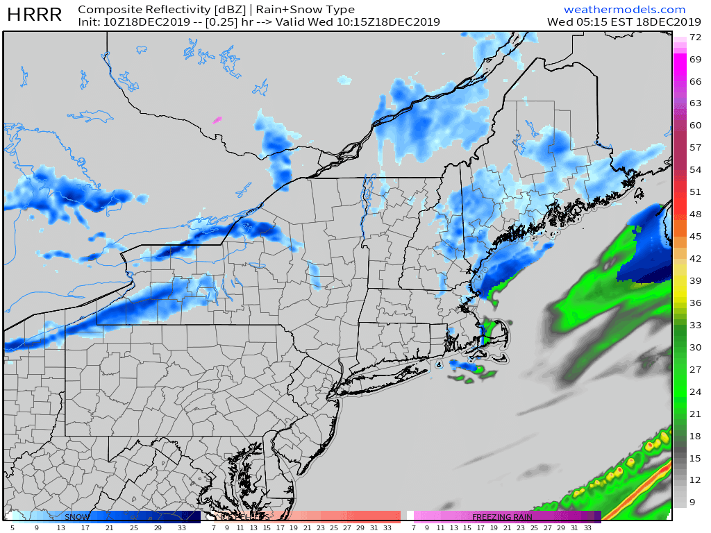
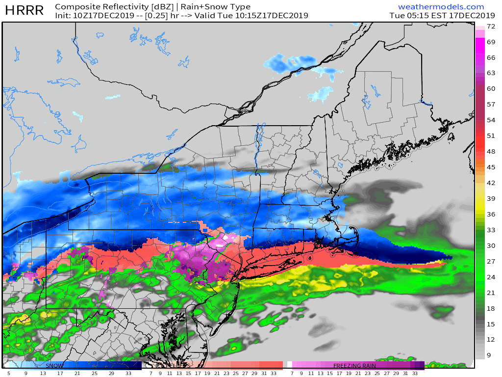
Heavy rain is falling across the region this morning as low pressure develops over the Mid Atlantic. As expected, the entire region has warmed above freezing and no additional icing issues are forecast. The batch of rain moving through currently will be the steadiest and heaviest of the day, so watch out for localized street flooding/ponding on roads during the morning commute.
During the mid-morning hours, drier air will work into the region about 5,000 feet off the ground. This will shut off the steadier/heavier precipitation, and most of the area will remain dry (possibly with some drizzle) through the mid afternoon hours. Another round of moderate/heavy rain, this time in the form of convective showers, will arrive from the south this evening, likely around 6 PM in southern NH, 7 PM near Portland, and 8 PM for the mountains. The process of returning this warm airmass to its rightful place in the tropics will begin tomorrow with gusty NW winds.
High temps today will range from 40 in the mountains to 55 along the coast.
Today will feature the beginning of a warming trend that will continue as our next storm rolls through the area tonight and tomorrow. The storm will be tracking to the west of the region, which means that aside from some light snow/sleet/freezing rain associated with the leading edge of the precipitation, this one will be all rain.
That leading-edge icy precipitation will arrive later this afternoon, but it will be very light and is only expected to last for a couple hours at most. If you’re headed out and about after 7 PM, especially away from the coastline, watch out for isolated slick spots but otherwise you’ll barely notice the couple flakes or ice pellets. Steadier and heavier precipitation arrives later tonight, and will almost exclusively fall as rain except perhaps for the coldest mountain/foothill valleys where light icing will continue until tomorrow morning.
High temps today will range from 30 in the mountains to 45 along the NH Seacoast.
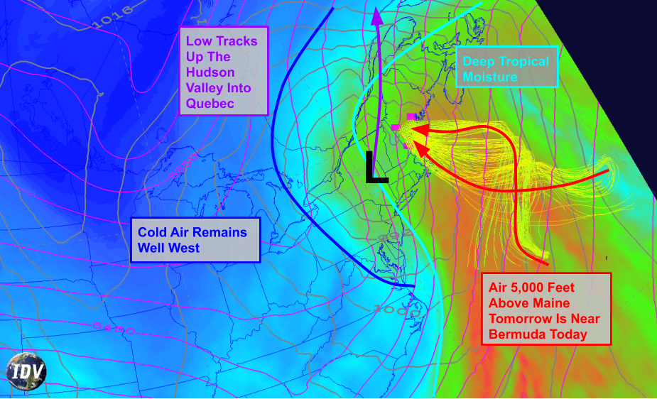
Curious why the storm tonight/tomorrow is expected to be mostly/all rain? Here’s a snapshot of one of the tools I use to figure out if it’s going to rain or snow. The shading depicts moisture content, with blue indicating dry air and green/red indicating moist air. Maine is firmly on the “moist” (east) side of the storm system, the center of which is tracking through the Hudson Valley. The moist side of the storm is also the warm side of the storm, and the airmass forecast to be over Maine tomorrow can be traced back to the Atlantic Ocean near Bermuda today.
With the storm passing to our west and air moving in from Bermuda, we can have high confidence that this one will end up mostly rain, even in the mountains.
Fellow snow lovers can take solace in the fact that this storm appears to be jolting our weather pattern back towards a more favorable configuration for cold air and snow, and there’s a pretty good chance most of the area ends up with a White Christmas (defined as >1″ of snow depth on Christmas morning or measurable snow accumulation >.1″ during Christmas Day).
Today will feature mostly clear skies and cool temps as a cold airmass continues to move into the region from Canada. This airmass is dry enough that even the upslope clouds along/northwest of the mountains will be relatively sparse. NW winds will continue gusting up to 30 mph today, which isn’t enough to be worried about power outages but will certainly make walking outside unpleasant if you’re not prepared. Later in the day, some high clouds will arrive from the WSW ahead of our next storm system which will bring rain to the region this weekend.
High temps will range from a little below 20 in the north to a little above 30 in the south.