Today will feature the arrival of colder air from Canada as northwesterly winds develop behind yesterday’s storm. These winds could gust over 30 mph at times, especially up in the mountains. As per usual with NW flow, expect more clouds than sun in the higher terrain along with some flurries while the coastal plain enjoys clearer skies. High temps will follow a similar pattern ranging from around 20 in the north to around 35 in SE NH.
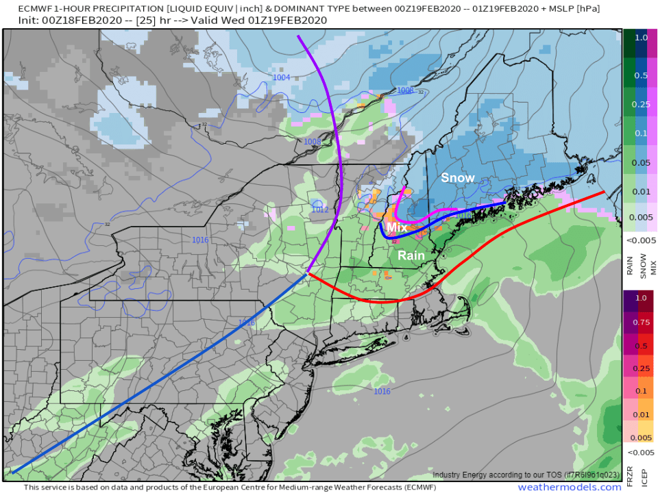
The winter of light snow events continues today as low pressure tracks through Ontario. Snow should begin falling in western parts of the area a little before noon and in eastern parts of the area a little after noon. Snow will initially be on the light/moderate side before becoming a bit heavier later in the afternoon/early in the evening.
Because the system is moving off to our west, and there’s no high pressure system over New Brunswick to lock in the cold, a changeover to rain is expected at least in southern parts of the area. Southern NH and coastal York County ME likely end up with rain by around 4 PM before the above-freezing surface air advances to a roughly Lake Winnipeasaukee – Sebago Lake – Midcoast Route 1 line around 7-8 PM. I don’t think the surface warmth will make it much farther north than that, but some warm air aloft will support a mix of freezing rain and sleet after 6 PM or so in the foothills. The mountains should stay all snow.
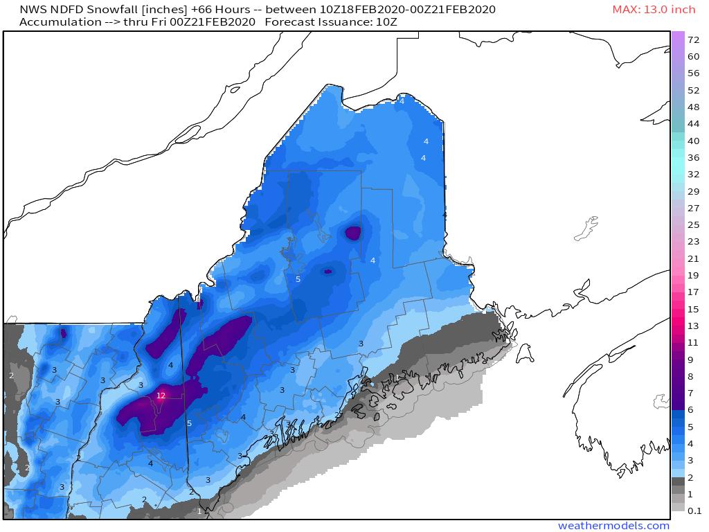
Here’s a look at how much snow our friends up at the NWS office in Gray (and, for northeastern Maine, Caribou) are expecting across the area today. As per usual, I might draw some of the contours slightly differently but those tweaks wouldn’t be significant. If you’re looking for >6″ of snow from this event, head up to the mountains. Most of the area will fall in the 3-6″ range while lower amounts are expected in southern NH and along the coastline (east of 95 south of Portland, south of Route 1 east of Brunswick) due to the expected changeover to rain.
Rain and snow will depart later tonight. High temps today will range from 25 up in the mountains to around 40 near Portsmouth NH.
Today will feature continued dry weather as our generally quiet pattern continues. A weak cold front moved offshore late last night, and light northwesterly flow has become established over the area in its wake. With that in mind, it’s no surprise that satellite imagery shows clear skies over the coastal plain while the mountains/foothills sit under a low cloud deck. Our traditional upslope/downslope pattern will persist into the mid afternoon hours before we run out of moisture and sunshine expands into the mountains.
High temps today will range from 25 in the north to 35 in the south. Clouds will return tomorrow ahead of our next storm system which is scheduled to arrive tomorrow night.
Today will feature a return to milder temperatures as the Arctic airmass we enjoyed yesterday departs to the east. Expect a few snow flurries this morning as the warm air begins to filter in, with the best chance for a dusting up in the mountains and along the Midcoast. High temps today will range from 30 in the north to 40 in the south. Mostly cloudy skies are expected across the area for the duration of the day as warm air continues to arrive aloft.
Today will feature cold and quiet weather as an area of Arctic high pressure quickly drifts offshore. Expect clear skies throughout the area today with the exception of some late afternoon cirrus in western parts of the area. High temps will rebound significantly from their current subzero readings, into the low 10’s (above) north and mid 20’s south. Today’s an awesome day to take advantage of the deep snowpack and enjoy your favorite winter recreational activities , just bundle up especially this morning.
For what I believe is the first (or maybe second) time this season, a true Arctic airmass is pushing into the region from the northwest this morning. As that cold air arrives today, expect breezy NW winds and a classic upslope/downslope pattern in terms of clouds and winds. The one exception this morning appears to be Portland and surrounding parts of York County where convergence from Mount Washington is producing a persistent layer of low clouds. If you’re curious why those clouds form, I’ve included a longer explanation below.
Temps today will be falling steadily as the colder air moves in. While temps currently range from around 5 in the north to around 25 in southern NH, by this evening northern areas will be in the 10’s below zero and the coast will dip into the mid/upper 10’s above zero. Bundle up!
If you look closely at the image above, you’ll see a swath of grey shading that’s just a bit brighter than its surroundings. That’s the band of low clouds forming in the shadow of the Presidentials. How does it form? As air approaches Mt Washington, it can either go around the mountain or over it. If you’ve ever hiked to the summit, you’ll know that going over the mountain is a hassle (though lots of fun!). Air parcels agree with the less exercise inclined among us: better to stick to lower elevations.
About half the air parcels decide to hang a left and go up through Gorham/Route 2 while the other half decide to hang a right and head down through Crawford Notch/Route 302. On the other side of the mountain, an area of low pressure exists just downwind of the summit. Remember (almost) all the air went around the mountain either through Gorham or Conway and there’s not much left for Pinkham Notch. This area of low pressure draws the two airstreams back together. This is known as convergence. When two airstreams converge in the low levels of the atmosphere, some air must rise because too much air is attempting to fit into too small a space near the ground.
This rising motion downwind of Mt Washington happens any time there’s wind in New England. What’s unique about today is that there’s just enough moisture present to allow for the weak upward motion produced by that convergence zone to produce clouds. Unfortunately for those in Portland, those clouds happen to be right overhead this morning. By later today, we should see drier air arrive in the area so those clouds should dissipate.
We seem to be nickel and diming our way back to respectable season snowfall totals as several light snow events have occurred across the region during the past week or so. Another of these light events will impact the region today. Radar imagery shows the first round of light/moderate precip departing the coast as of 5:45 AM with a break in precip over NH/VT and another round of snow back in NY. The area of low pressure responsible for producing these bands of snow is weak, elongated, and drifting east over Pennsylvania.
As a result, I suspect most spots only have another inch or maybe two to pick up during the rest of the morning. Seeing as temps along the coastal plain range from around 30 to around 34, I wouldn’t expect any issues on road surfaces that have gotten a bit of salt. Perhaps the back roads could be slick though. Leftover snow from this system departs to the east this afternoon.
This evening, all eyes will turn to the approach of a strong Arctic front. Snow showers and squalls will develop along the leading edge of the colder air and could drop another quick coating-1″ after sunset. Behind the front, NW winds will pick up and temps will quickly drop as a brief shot of true Arctic air arrives.
After our very light snow/rain event yesterday, we’re headed for more authentically “quiet” weather today as high pressure slides through the Mid Atlantic. Northwesterly flow ahead of that high will set up a familiar pattern for longtime readers and watchers of ME/NH weather. Expect mostly cloudy skies in upslope flow across the mountains while the coastal plain enjoys abundant sunshine. A few snow showers from the mountains have escaped into interior parts of York and Cumberland counties this morning, but no accumulations are expected outside of 1-3″ in the higher terrain.
High temps will once again fall on the milder side of climatological normals, ranging from 30 in the north to 40 in the south.
Another weak area of low pressure will race by to our south today as a weak upper level disturbance zips northeast. This system won’t get its act together until it’s way out in the North Atlantic, so we can safely rule out any heavy precip. That said, there should be just enough moisture and lift to produce some scattered showers and possibly a brief period of light steady precipitation across parts of western ME and NH today. Precip is most likely between 11 AM and 5 PM in southern parts of the area. Temps will be hovering in the mid/upper 30’s over this area this afternoon, so precip will fall as a mix of rain/snow. As a result, any accumulations should be limited to <1″ on colder surfaces.
High temps will range from 30 in the north to 40 in SE NH.
The light snow event that has been ongoing over the past few hours will depart off to the east in the next few hours. Warm air has moved onshore in the typical spots (Midcoast peninsulas and east of 295/95 south of Brunswick) but otherwise most of the area (except southern NH) is experiencing light snow. We have about 5-6 hours of on and off snow left before drier air works in from the west. I haven’t seen a lot of reports at this hour of the morning, but there’s no reason to believe we’ll pick up any more than 2-4″ when this system is over. In the grand scheme of things, it’s a pretty weak disturbance.
High temps today will range from 32 in the northern mountains to 40 in southern NH and SW ME. A couple breaks of sun are possible in western regions this evening but otherwise today will be overcast for all.