Hello everyone!
A “cold front” is struggling to push east across the region this morning as a storm moving through Quebec tries to push drier air in our direction while tropical moisture begins streaming north ahead of Isaias. Dew points currently in the upper 60s to low 70s should fall off into the lower 60s or even upper 50s in western parts of the region by this afternoon. The humidity will linger a bit more along the coastline. Winds behind the boundary this afternoon will be from the west-southwest which is favorable for warm temps, especially along the coastline. With that in mind, expect highs ranging from the mid 70s up north to the low 90s along the coastal plain.
Skies will feature a mix of sun and clouds today as various disturbances drift overhead and leftover low-level moisture clears out. The best chance for cloud-cover will be up in the mountains while the coastal plain will see more sunshine. No precipitation is expected until late tonight in advance of Isaias.
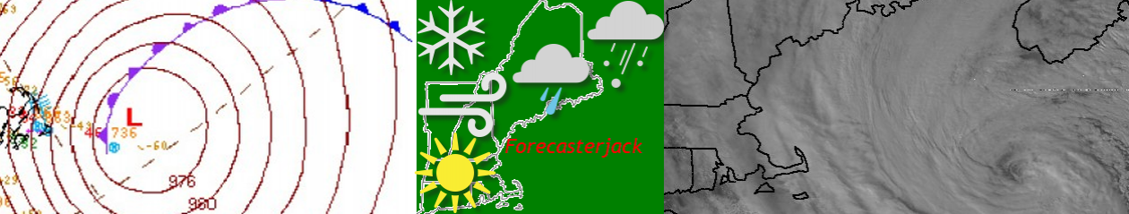
Speaking of Isaias, the system is still expected to impact our area as a tropical storm tomorrow. The track has shifted a bit to the west since yesterday’s update which means that more of us will be on the windy side of the storm rather than the rainy side.

Flash flooding will still be possible in the mountains where the heaviest rain (2-5″ localized 6-8″) will fall. Most of us though will end up with a brief round of showers and storms that could drop an inch or two of rain. That will be welcome news for parched lawns and gardens, but generally isn’t much of a flooding concern (except for the usual poor drainage spots that flood every time we get a thunderstorm).

The bigger story for most of us will be the strong winds. As the storm passes to the west, we’ll see southeasterly winds pick up during the day tomorrow. Currently, most coastal spots should expect gusts to 45-55 mph with a few 60 mph readings not impossible in embedded stronger thunderstorm cells. Inland, winds should top out around 35-45 mph. This is enough to knock down trees and powerlines, especially given that these gusts will be from the southeast. As we learned in October 2017, our area is particularly vulnerable to tree damage from southeasterly winds because they don’t happen very often (but when they do, they’re usually quite strong). So be prepared for a bit of time without power tomorrow night and Wednesday. Unless the storm really pulls itself together today, I’m not expecting widespread major issues. This is about as strong as one of the stronger non-tropical storms we might get in late fall.
One last note is that the environment will be favorable for tornadoes as Isaias passes just west of the region probably tomorrow night (this storm has been really frustrating to figure out timing). By virtue of tornadoes being spatially confined phenomena, the odds of one striking your house is extraordinarily small. That said, you should have a way to get warning information from our friends up at NWS Gray if they issue a tornado warning for your area. Remember that the best place to be during a tornado is in your basement or an interior room on the first floor with no windows. We very rarely have to worry about tornadoes up here, but tropical cyclones are one good way to produce them. The last time we had a tropical cyclone pass to our west (Fay earlier in July), we also had a tornado (EF0 near Sebago Lake).
Here’s a timelapse I took of that storm looking WSW from Hackers Hill in Casco.
I’ll have another update on Isaias tomorrow morning at the usual time, or perhaps this evening if there are significant changes to report.
-Jack

What a waste of all this humidity we’ve had to put up with. Some models deliver less than an inch of rain to most of Maine.